Showing 1383 items matching "divided"
-
 Robin Boyd Foundation
Document - Lecture, Robin Boyd, (Modern Architecture), 1962
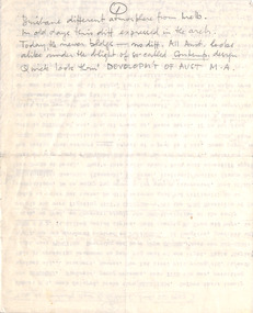
Rough, heavily annotated notes for lecture to be given to a Brisbane audience. Boyd divides modernist architects into a Romantic camp (citing Yamasaki, I.M. Pei, Paul Rudolph, Ed Stone) and a Realist camp (citing Kenzo Tange and the New Brutalists), then proposes a third category of 'Creative Realism' and defines some criteria for this type of architecture.Speech given to students at the University of Queensland 24.6.1962Typewritten, major pencil edits and additions, foolscap, 1 folded pagesExtensive handwritten edits, notes and revisionsminoru yamasaki, i.m. pei, paul rudolph, edward stone, kenzo tange, robin boyd, manuscript -
 4th/19th Prince of Wales's Light Horse Regiment Unit History Room
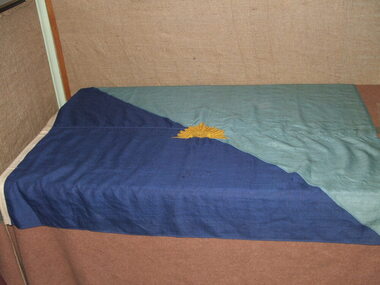
Regimental Flag, 4th Light Horse Regiment, 1918 (estimated)
High Significance. A Unit flag proclaiming to anyone approaching RHQ's location that this is the 4th Light Horse. Anyone who was famliar with the Colour Patch system of the Australian Imperial Force, would know from observing the flag that this unit is the 4th Light Horse Regt.4th Light Horse Regiment , "Two Blues" Flag, diagonally divided from upper left to lower right corner, light blue top, dark blue lower. 200 x 90 mm gold rising sun badge in centre. Rising Sun is likely to have been hand embroidered.. A wooden securing toggle is attached to the flag. Not anyflag, 4th light horse -
 Flagstaff Hill Maritime Museum and Village
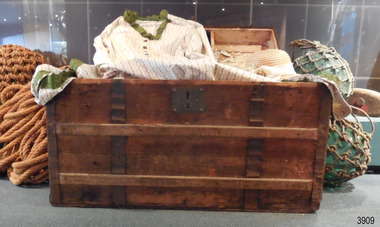
Functional object - Trunk, late-19th to mid-20th century
Trunk is made strong for long journeys and rough use. Tray compartments would have been fitted inside the lid for storage of smaller items such as hats, umbrellas and underclothing. The illustration pasted inside the lid is similar to those shown in women's fashion journals of the 1880s and 1890s. A similar trunk was found in the catalogue of Anthony Hordern & Sons, a large and famous late 19th to mid 20th century retailer in Sydney,.This trunk is an example of the typical travel luggage of people migrating to the Colony of Australia in the late 19th century.Wooden cabin trunk, rectangular, brown in colour. Lid has arched top, front has a strong padlock, sides have leather strap handles. Corners and edges are reinforced with iron, iron bands and extra wooden slats. Lid is divided into tray compartments. A print of a female in 19th century costume is attached to the inside the lid in one compartment. flagstaff hil, warrnambool, flagstaff hill maritime museum, maritime museum, shipwreck coast, flagstaff hill maritime village, great ocean road, trunk, cabin trunk, travel trunk, cargo, storage, women's fashion, late 19th century fashion, travel luggage, travel goods -
 Whitehorse Historical Society Inc.
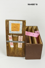
Container - Ticket box
This dispenser was used by personnel working in the Nunawading City Council Historical Cottage, now known as Schwerkolt Cottage. The public gained entrance by purchasing adult / child tickets until about 1992When the council was renamed Whitehorse City Council. since that time entrance has been free.Wooden Ticket Dispenser, the top is manufactured with handmade painted base. Tickets for Child and Adult Admission held in place on top by a metal bar. Handwritten 'Instructions showing pricing and number of children admitted for free'. Instructions that cash box and float are correct. Inside of box divided into three sections, two of which contain what are fed into corresponding openings in the lid.commerce, dispensers, containers, commercial, documents, tickets -
 Ballarat Tramway Museum
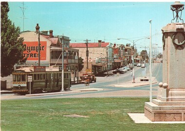
Postcard, Nu-color-vue or Nucolorvue Productions, "Eagle Hawk Victoria" "Eaglehawk, Victoria", mid 1960's?
Postcard - colour photograph of High St Eaglehawk, with No.3 at the Eaglehawk tram terminus. Has The Cenotaph on the right hand side. Nu-colour-vue postcard, EH1. Divided back, printed in Australia. Has the various stamp values required for postage in Australia, New Zealand, UK and the USA in the stamp section. Has a kangaroo logo in the centre bottom or the rear. trams, tramways, bendigo, postcards, eaglehawk, high st -
 Ballarat Tramway Museum
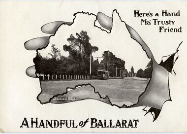
Postcard, H&B, ESCo No. 18 in Wendouree Parade, c1910
Printed black and white postcard of ESCo No. 18 in Wendouree Parade within a map of Australia, being held by hand. Features photograph in Reg. Item No. 471. Titled "A Handful of Ballarat", with words "Her's a hand Ma' Trusty Friend". On rear, the post card has been divided into two with a the words "post card" and artistic symbol with the initials "H&B". trams, tramways, wendouree parade, esco, postcards -
 Ballarat Tramway Museum
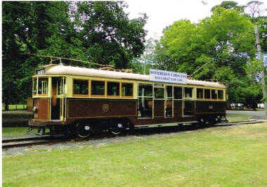
Postcard, Ballarat Tramway Museum (BTM), Postcard of BTM tram No. 661, 2014
Postcard of BTM tram No. 661 on the access track with the Sovereign Caravans Ad. Photo taken during 2014. Printed in Ballarat by???. On the rear has the words "Ballarat Tramway Museum / No. 661 W3 class c1932 / Limited Edition 1/50, c BTM 2014" Has a divided back with a 8mm thick black line on the right hand side.trams, tramways, w3 class, btm, access track -
 Ballarat Tramway Museum
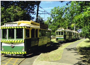
Postcard, Ballarat Tramway Museum (BTM), BTM Trams on access track, 2014
Postcard of BTM trams on the access track taken during 2014. No. 14 parked by footpath at the east end of the access track, then No. 40 and 38. Printed in Ballarat by???. On the rear has the words "Ballarat Tramway Museum / Limited Edition 1/50, c BTM 2014" Has a divided back with a 8mm thick black line on the right hand side.trams, tramways, btm, access track, wendouree parade, tram 14 -
 City of Greater Bendigo - Civic Collection
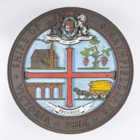
Sign - Shire of Strathfieldsaye Coat of Arms
The district of Strathfieldsaye was proclaimed in 1861 and named a Shire on the 17th September in 1866. It remained a shire until amalgamation in 1994 when it became part of the City of Greater Bendigo. The shire was located 8 km to the south- east of Bendigo and covered an area of 601 square kilometres and extended from the Calder Highway to the Coliban and Campaspe Rivers. The shire's administration centre was in Strathfieldsaye until 1972 when new offices were opened in Kennington. This coat of arms was commissioned for the front of the shire hall building.Brass painted coat of arms or emblem within a circle of the Shire of Strathfieldsaye. Outer rim contains text: SHIRE OF STRATHFIELDSAYE VICTORIA 1866 with the shield of the monarch of the United Kingdom centre top. The shield is divided into four parts with images reflecting the leading industries of the time; wine growing, mining, farming and tanning. The motto PROGRESS is depicted lower centre of shield. SHIRE OF STRATHFIELDSAYE / VICTORIA / 1866 / PROGRESSshire of strathfieldsaye, city of greater bendigo amalgamation, city of greater bendigo signs -
 Melbourne Tram Museum
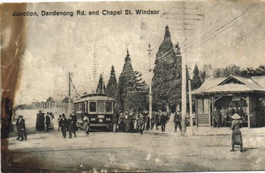
Postcard, "Junction, Dandenong Rd and Chapel St Windsor", c1910
Postcard photo of PMTT tram 14 at the junction of Dandenong Road and Chapel St Windsor with many people either leaving or joining the tram. On the right hand side is a PMTT shelter with a number of people standing in it. Divided back with spaces for Correspondence, address and stamp. Stamp area has "Printed in county of Saxony" and number 3949 in bottom right hand corner.trams, tramways, pmtt, dandenong rd, chapel st, shelters, tram 14 -
 Melbourne Tram Museum
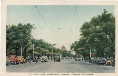
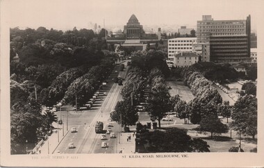
Postcard, Nu-color-Vue, "St Kilda Road, Melbourne looking towards the shrine", c mid 1950s
Postcard - colour titled "St Kilda Road, Melbourne looking towards the shrine". Has wide bodied tram in the distance and a number of vehicles, mostly parked, pedestrians and a shelter. On the rear - has a divided back, with details noting that the road has the capacity of 10 car lanes and twin tram lines. Produced by Nucolorview, using a genuine Kodachrome photographOn the rear has the stamp of Graeme S Breydon - see image i2.trams, tramways, melbourne, st kilda rd, shrine of remembrance, shelters -
 Melbourne Tram Museum
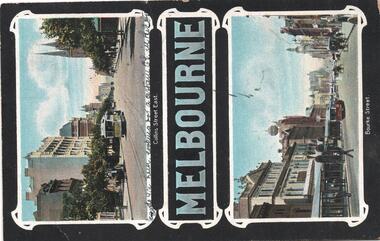
Postcard, "Melbourne - Collins St and Bourke St", mid 1900's?
Divided back printed in colour postcard featuring two photos, one of Collins St and Bourke St, both looking west with cable trams in the view, titled "Melbourne - Collins St and Bourke St" Rear has space for stamp, address, message. Has been used for a message to Miss A Hall of Blackwood, with a 1d stamp, cancelled in Melbourne.trams, tramways, cable trams, collins st, bourke st, melbourne -
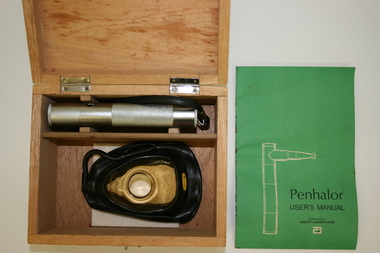 Geoffrey Kaye Museum of Anaesthetic History
Equipment - Inhaler, Analgesia, Penthrane
Originally distributed by Abbott Laboratories. This device is used for the self-administration of Penthane, an analgesic. Designed for use in emergency rooms, obstetrics, orthopaedics and surgical outpatients.Wooden box with metal clasp and hinges and two sections inside, divided by balsa wood. One side contains an amber plastic and black rubber facial mask, along with a inhaler tube and felt square. The other side contains a cylindrical metal device with a black plastic handle secured to one end and a portal for attaching the facial mask at the other.penthrane, analgesia, self-administration -
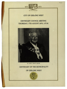 Federation University Historical Collection
Booklet, City of Geelong West: Centenary Council Meeting and Dinner, 1975
The Geelong West Coat of Arms is divided into four sections representing Transport, Industry, Shipping and Agriculture. For Transport (top left) a steam train typified the Geelong-Melbourne railway. Top right showed a factory, bottom left was a sailing clipper and bottom right had bales of wool. The modern adaptation of the official Coat of Arms is used in the booklet.1 Booklet pages are edged with gold with banner at top. Yellow ribbon at spine. Photographs of councillors and Governor of Victoria .2 Thick paper with red writinggeelong west, coat of arms, transport, industry, agriculture, louis keavy, mayor, centenary, governor of victoria, sir henry winneke, government gazette -
 City of Kingston
Photograph - Black and white, 3 March 1954
Cheltenham and Moorabbin are suburbs within the City of Kingston that were originally established as rural market gardening communities The area is bordered by Highett and Mentone. The market gardens, farms and paddocks have gradually been sub-divided into housing and industrial estates. Highett is developed with residential homes but was also the site of major facilities such as the Highett Gas Works. This aerial image covers a diverse section of the City of Kingston, taking in the suburbs of Moorabbin, Cheltenham, Highett and Mentone Residential housing development is prominent along the Frankston Railway line and the area still retains extensive market gardens and paddocks yet to be converted to a large industrial and commercial zone.Aerial photograph of Mentone, Cheltenham and Moorabbin within the City of Kingston. The area depicted in this 1954 aerial view includes Warrigal Road and Centre Dandenong Road intersection (top left); Charman Road, Patty Street, Bourke Street, Collins Street Mentone (top right); Keys Road Moorabbin (bottom left); Bay Road, Cheltenham (bottom right), Friendship Square, Cheltenham Park, Victoria Golf Club and Jack Barker Oval are visible. Nepean Highway and the Frankston railway line run centrally through the image. Highett Gasworks is also evident.White handwriting and type [indecipherable]. White image of clockface White image of compass White type 42956 Black handwriting 3/3/54 Williams [indecipherable] Black pencil: S [arrow] Black ink: 3/3/1954cheltenham, moorabbin, mentone, highett, market gardens -
 Warrnambool and District Historical Society Inc.
Audio - Audio tapes, Shire Centenary meeting 1963, Circa 1963
The Warrnambool Shire commenced in 1863 and was 613 square miles in area and had a population of about 8000. It was divided into three ridings each with three councillors. Its industries were dairying, general farming, cheese and butter making, wool growing, sheep and cattle raising. There are more than 20 parishes and more than 29 small townships in the area The industries, agriculture, and people of the Warrnambool Shire provided substantial support to the city of Warrnambool over a long period of time. Three audio reel to reel tapes two in green and white boxesShire Centenary meeting 1963 tape1, 2, 3. depth. Two tapes stored in grey and white cardboard box, Irish recording tape, a product of AMPEXwarrnambool, warrnambool shire council, warrnambool shire centenary -
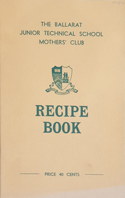 Federation University Historical Collection
Booklet, Ballarat Junior Technical School Mothers' Club, Recipe Book
The Ballarat Junior Technical School was a division of the Ballarat School of Mines. The Recipe Book was produced by the Mothers' Club. Recipes were divided into sections: Soups, Savouries, Meat dishes, Desserts, Tea Cakes and Loaves, Biscuits and Slices, Cakes, Jams, Pickles and Sauces, Miscellaneous. There were Catering Hints and Handy Tips included. Booklet cost 40 cents.Yellow soft covered recipe book. The name of the person who provided each recipe is printed beside the recipe.ballarat junior technical school, recipes, ballarat junior technical school mothers' club, cooking, kitchen, hospitality -
Frankston RSL Sub Branch
Cream, Face Paint
Small container of AUSTCAM camouflague face paint supplied by the Australian Department of Defence during the Vietnam conflict. The plastic container is Army jungle green and in the form of a small rectangular resealable container with a tight fitting lid. The container has a mirror on the inside of the lid and is divided into three sections. The face paint is coloured dark green, light olive green and brown and all are unused. The container has the following printed in black ink "WARNING KEEP OUT OF EYES", "AUSTCAM", PAINT FACE CAMOUFLAGUE", "NSN 6850-66-130-0172", "MILITARY SUNSCREEN" -
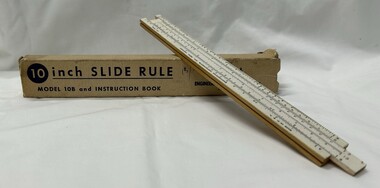 Greensborough Historical Society
Functional object - Ruler, Engineering Instruments, Inc, 10 inch slide rule model 10B and instruction booklet, 1947-1967
George Lee Lawrence (1901–1976) established a firm in Chicago to make slide rules for photography. In 1935 he moved to Wabash, Ind., renamed the company Lawrence Engineering Service, and began to manufacture general purpose slide rules. In 1938 he relocated once more to Peru, Ind., and in 1947 it was changed to Engineering Instruments, Inc., and the company remained in business until its building burned down in 1967. The model 10-B sold for 25 cents during this period. There is no record that Lawrence ever received a patent for any aspect of his design or manufacturing process.Used up to the 1960s prior to the invention of the electronic calculator.10 inch one-sided wooden slide rule painted white on the front face, which consists of two divided scales, one fixed and on movable, and a sliding window called a cursor. A, D, and K scales are on the base, and B, CI, and C scales the inside of the slide. The underside of the rule is marked with: tables for equivalents and conversions. Housed in cardboard box with instruction booklet.The top of the base is marked: MADE IN U.S.A. It is also marked ENGINEERING INSTRUMENTS, INC., PERU, INDIANA and PAT. PEND. Underside: This Famous Slide Rule... at a popular price. Solves Problems in Multiplication, Division, Proportion, Squares Roots, Cubes and Cube Roots, Reciprocals, etc., Instantly. Accurately Calibrated White Face on Well Seasoned Hardwood. Both ends of box: MODEL 10B-BK Price of 15 shillings handwritten on box.slide rule, mathematics -
 4th/19th Prince of Wales's Light Horse Regiment Unit History Room
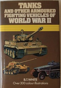
Book, Peerage Books, B T White: Tanks and Other Armoured Fighting Vehicles of World War II, 1972 (exact)
This book covers the period 1939-45, which was the most momentous period in the history of the tank. Includes 160 pages of coloured drawings with descriptive text. The book is divided into two sections - Book 1 dealing with 'Blitzkrieg Era' of 1939-41, and Book II covering the years 1942-5, in which some of the greatest tank battles of all time took place. ISBN 0 907408 35 4world war 2, military history, tanks, armour, armoured fighting vehicles, b t white, world war 2, military history, tanks, armour, armoured fighting vehicles, b t white -
 Warrnambool and District Historical Society Inc.
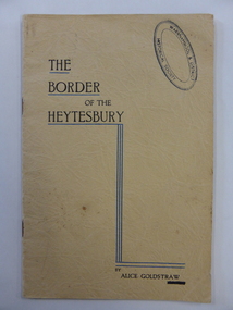
Book, The border of the Heytesbury, 1937
This book has been written by Alice Goldstraw in 1937. It is a fine history of life in the Naringal/Cudgee/Heytesbury Forest area at the end of the 19th century. There are accounts of the bushland, the school and the people in the area. Alice Goldstraw (d. 1967) was the daughter of George and Robina Goldstraw who were pioneer farmers in the Cudgee area. The Goldstraw families were prominent in the early history of Warrnambool and district, especially as timber millers and sawyers. This book is of considerable importance as it is a rare copy of ‘The Border of the Heytesbury’ written by Alice Goldstraw. It provides a wealth of material for researchers. An index to the book has been compiled by the Warrnambool and District Historical Society. This is a soft cover booklet of 34 pages. It has a buff-coloured cover with black printing and blue lines on the front cover. There is also a Warrnambool & District Historical Society stamp on the front cover. There are eleven chapters on ‘The Border of the Heytesbury’ and one chapter on ‘Some People in the Heytesbury’. The printed pages are divided into two columns. The pages have been stapled but the staples have been removed.history of cudgee/naringal/heytesbury forest area, history of warrnambool, alice goldstraw -
 Bendigo Historical Society Inc.
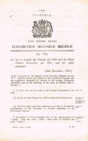
Document - BENDIGO SALEYARDS COLLECTION: POUNDS (AMENDMENT) ACT 1968
a. An Act to amend the Pounds Act 1958 and the Sheep Owners Protection Act 1961. Dated 18/12/1968. No 7756. Paper with a crest at the top of a lion wearing a crown on the left and a unicorn on the right of a shield with a crown at the top. Shield divided into four. Details various amendments to the Act. b. An Act to amend the Pounds Act 1958, dated 17 December 1958, No. 8643.bendigo, council, cattle markets, bendigo saleyards collection - pounds (amendment) act 1968, a c brooks -
 Bendigo Historical Society Inc.
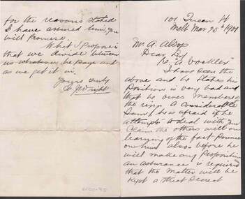
Document - KELLY AND ALLSOP COLLECTION: LETTER TO MR A. ALLSOP, 15/03/1901
Handwritten letter to Mr. A. Alsop from? J. Wright re. A. Bockler who owes money. Bockler's circumstances are very bad and he's afraid if word gets out he is paying some people, others will jump on him for money and he would like to keep it a secret. Wright proposes that he and Alsop divide whatever he pays between them as they get it.business, stockbroker, kelly & allsop, kelly and allsop collection - letter to mr. a alsop, a bockler -
 Wangaratta RSL Sub Branch
Coin, Royal Mint, circa 1711
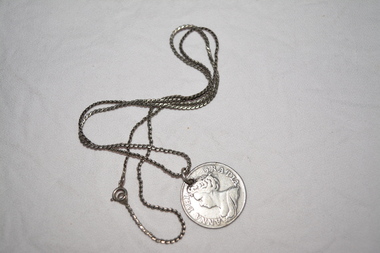
Circa 1711 Queen Anne silver shilling coin Round silver coin with bust of woman - ANNA DEI GRATIA - silver chain attached Reverse side - Crowned shields - with arms of England and Scotland impaled at top and bottom, Ireland at left and France at right, forming a cross shape with the badge of the Star of the Garter at the centre; around, MAG BRI FR ET HIB REG 1711, the date being divided by a crown.coin, queen anne -
 Bendigo Historical Society Inc.
Administrative record - Land Register
Title on the front says - Bendigo Sec 12, Register. Large land register book. Board cover and back - covered by material of blue silk and leather. Paper on the inside - 101 pages - handwritten. Each page is divided into application numbers, full names, dates of application, parish of address, and details regarding the land and what is being done with it. Dates approx. ~ 1895 - 1949Written on spine - 5 12 1 7 1. Front cover large capital B on the side of the cover and in the middle is Bendigo Sec 12 Register. land register, financial, bendigo -
 Bendigo Historical Society Inc.
Slide - DIGGERS & MINING. THE GOLD LICENCE, c1853
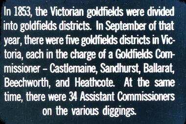
Diggers & Mining. The gold licence. The Government Camp. In 1853, the Victorian goldfields were divided into goldfields districts. In September of that year, there were five goldfields districts in Victoria, each in the charge of a Goldfields Commissioner - Castlemaine, Sandhurst, Ballarat, Beechworth, and Heathcote. At the same time, there were 34 Assistant Commissioners on the various diggings. Markings: 30 994.LIF. 4. Used as a teaching aid.hanimounteducation, tertiary, goldfields -
 Melbourne Tram Museum
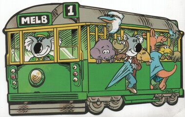
Postcard, Nu-color-Vue, novelty style, cut out around a Melbourne W class cartoon image, c1980
Postcard - novelty style, cut out around a Melbourne W class cartoon image of a tram being driven by a Koala with Australian animals as passengers. Destination of "MELB", route 1. Produced by Nu-color-Vue Divided back has the production company details on rear and stamp position with the numbers 11 ML318 and NCV 6064 inside it. Produced during the 1980's.trams, tramways, w class, cartoons, novelty postcards, melbourne, route 1 -
 Melbourne Tram Museum
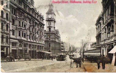
Postcard, Marlborough Series, "Burke St Melbourne Looking East", c1910
Postcard photo of Bourke St looking east from about half way between Elizabeth and Queen St with the Melbourne GPO, Post Office in the middle of the photograph, along with a number of horse drawn vehicles and cable trams. mid 1900's (c1905). Divided back with spaces for Correspondence, address and stamp. On right hand side in red "Marlborough Series" (Printed in Australia)trams, tramways, cable trams, bourke st, horse drawn vehicle -
 Melbourne Tram Museum
Postcard, Rose Stereograph Co, "St Kilda Road, Melbourne Vic", c late 1950s
Postcard - Black and White - Rose Series P4311, titled "St Kilda Road, Melbourne Vic" - looking south with the Shrine of Remembrance and Prince Henry Hospital in the background. Has a number of trams in the view. Possibly taken from the clock tower at Flinders St station. On the rear - has a divided back, and "A Real Photograph" " & Produced in Australia" and the Rose logo and address details.On the rear has the stamp of Graeme S Breydon - see image i2.trams, tramways, melbourne, st kilda rd, shrine of remembrance -
 Melbourne Tram Museum
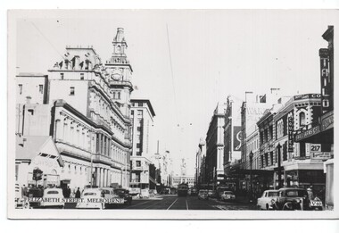
Postcard, Valentine's, "Elizabeth St, Melbourne", 1950's
Postcard - Black and White - Valentines Elizabeth St Melbourne" number V40 - looking south with the Flinders St station in the background. Photo taken at Little Bourke St, with the Post Office, Alan Taylor Tin shed on the left, Couties Boots, Small Arms Co building and Tailo Hardware. On the rear - has a divided back, and "A Real Photograph" " & Produced in Australia" and the Valentine's logo.On the rear has the stamp of Graeme S Breydon - see image i2.trams, tramways, elizabeth st, gpo, post office