Showing 8847 items matching "greensborough historical society"
-
 Eltham District Historical Society Inc
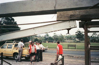
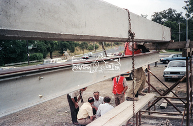
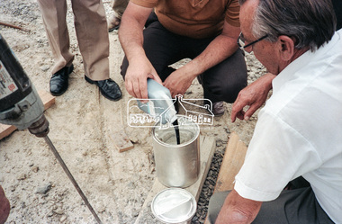
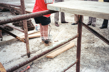
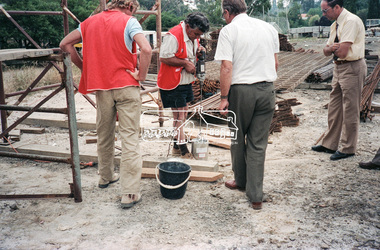
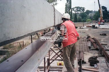
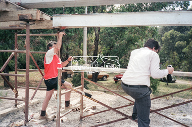
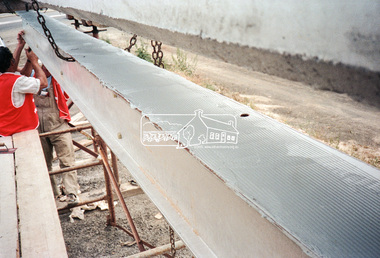
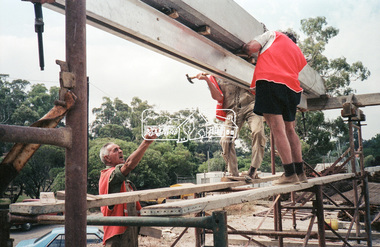
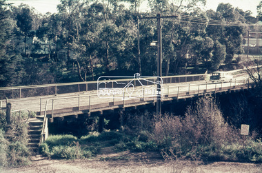
Negative - Photograph, Construction work, Main Street Bridge, Greensborough, c.Dec. 1983
The original bridge over the Plenty River was replaced by a single lane bridge each way fed by two lanes each way on either side. As traffic grew a second bridge was added to complete the divided road across the riverFilm - Kodak CM 400 5079 7 strips, 26 framesinfrastructure, roads, bridge construction, greensborough, main street bridge, road construction -
 Eltham District Historical Society Inc
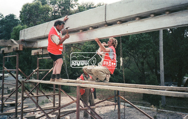
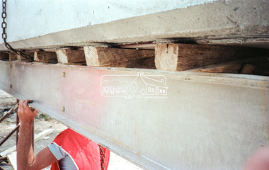
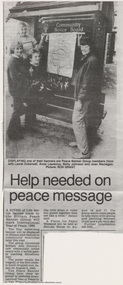
Document - Newspaper article, Diamond Valley News, Help needed on peace message, Aug 1986
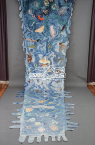
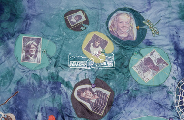
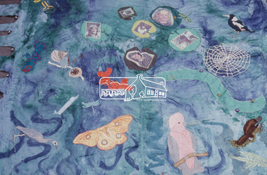
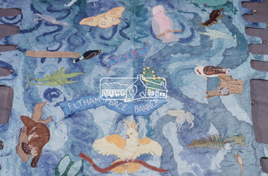
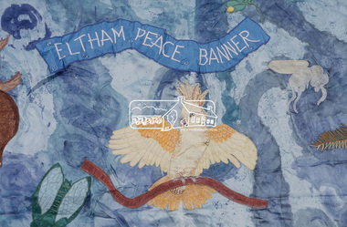
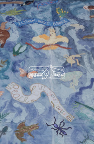
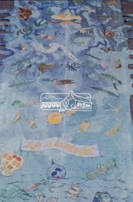
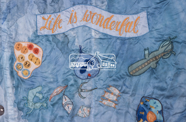
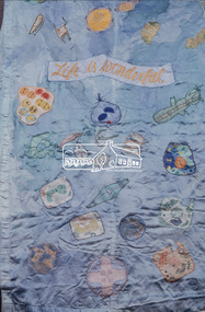
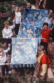
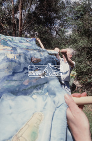
A River of Life: Eltham Peace Banner 1986 The Hiroshima Day Banner was conceived by Shire of Eltham Artist in Residence, Jacky Talbot and a number of other Eltham women as part of the “As We Are” community banner project. The women wanted to do something for Hiroshima Day and suggested that a workshop be set aside to make a banner. The group promoted it at the new Community Notice Board (Arthur Street and Main Road) on Hiroshima Day (August 6) and were photographed by the local newspaper publicising the group and drawing wider community attention to the remembrance of the day. Jacky Talbot, led the team who produced the banner, approximately 4.5 metres by 1.5 metres, of sewn and painted Australian flora and fauna. Workshops were held at the Eltham Community Arts Centre at Meruka House. Peace Banner Group members included Laurel Eckersall, Anne Laurence, Betty Johnson, Margaret Johnson and Joan Maclagan. One of the creators, Joan Maclagan, further gave expression in verse – Banner for Peace The 'River of Life' with about 30 other banners went on display in the “As We Are” exhibition held at the Eltham Community Centre on 9 October 1986, previewed by the Member for Greensborough, Ms Pauline Toner, and Eltham Shire President, Mr Bob Manuell. The full display continued in Woolworths (now Coles) Arcade. The banner was also carried by the group in the 1986 Eltham Festival Grand Parade on November 8, along with other group banner projects including that of the Eltham District Historical Society, after which they were displayed in the Shire of Eltham’s tent in Alistair Knox Park.anne laurence, betty johnson, display panel, eltham peace banner, hiroshima day banner, joan maclagan, laurel eckersall, "as we are" community banner project, banner project, river of life banner, community notice board, jacky talbot -
 Eltham District Historical Society Inc
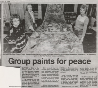
Document - Newspaper article, Diamond Valley News, Group paints for peace, 30 Sep 1986
A River of Life: Eltham Peace Banner 1986 The Hiroshima Day Banner was conceived by Shire of Eltham Artist in Residence, Jacky Talbot and a number of other Eltham women as part of the “As We Are” community banner project. The women wanted to do something for Hiroshima Day and suggested that a workshop be set aside to make a banner. The group promoted it at the new Community Notice Board (Arthur Street and Main Road) on Hiroshima Day (August 6) and were photographed by the local newspaper publicising the group and drawing wider community attention to the remembrance of the day. Jacky Talbot, led the team who produced the banner, approximately 4.5 metres by 1.5 metres, of sewn and painted Australian flora and fauna. Workshops were held at the Eltham Community Arts Centre at Meruka House. Peace Banner Group members included Laurel Eckersall, Anne Laurence, Betty Johnson, Margaret Johnson and Joan Maclagan. One of the creators, Joan Maclagan, further gave expression in verse – Banner for Peace The 'River of Life' with about 30 other banners went on display in the “As We Are” exhibition held at the Eltham Community Centre on 9 October 1986, previewed by the Member for Greensborough, Ms Pauline Toner, and Eltham Shire President, Mr Bob Manuell. The full display continued in Woolworths (now Coles) Arcade. The banner was also carried by the group in the 1986 Eltham Festival Grand Parade on November 8, along with other group banner projects including that of the Eltham District Historical Society, after which they were displayed in the Shire of Eltham’s tent in Alistair Knox Park.betty johnson, eltham peace banner, hiroshima day banner, laurel eckersall, "as we are" community banner project, banner project, river of life banner, community notice board, margaret johnson, meruka house, community arts centre, jacky talbot -
 Eltham District Historical Society Inc
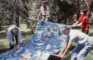
Slide - Photograph, Jacky Talbot, River of Life: Eltham Peace Banner, Sep 1986
A River of Life: Eltham Peace Banner 1986 The Hiroshima Day Banner was conceived by Shire of Eltham Artist in Residence, Jacky Talbot and a number of other Eltham women as part of the “As We Are” community banner project. The women wanted to do something for Hiroshima Day and suggested that a workshop be set aside to make a banner. The group promoted it at the new Community Notice Board (Arthur Street and Main Road) on Hiroshima Day (August 6) and were photographed by the local newspaper publicising the group and drawing wider community attention to the remembrance of the day. Jacky Talbot, led the team who produced the banner, approximately 4.5 metres by 1.5 metres, of sewn and painted Australian flora and fauna. Workshops were held at the Eltham Community Arts Centre at Meruka House. Peace Banner Group members included Laurel Eckersall, Anne Laurence, Betty Johnson, Margaret Johnson and Joan Maclagan. One of the creators, Joan Maclagan, further gave expression in verse – Banner for Peace The 'River of Life' with about 30 other banners went on display in the “As We Are” exhibition held at the Eltham Community Centre on 9 October 1986, previewed by the Member for Greensborough, Ms Pauline Toner, and Eltham Shire President, Mr Bob Manuell. The full display continued in Woolworths (now Coles) Arcade. The banner was also carried by the group in the 1986 Eltham Festival Grand Parade on November 8, along with other group banner projects including that of the Eltham District Historical Society, after which they were displayed in the Shire of Eltham’s tent in Alistair Knox Park.betty johnson, eltham peace banner, hiroshima day banner, laurel eckersall, "as we are" community banner project, banner project, river of life banner, margaret johnson, meruka house, community arts centre, jacky talbot, eltham shire council artist in residence -
 Eltham District Historical Society Inc
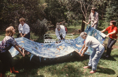
Slide - Photograph, Jacky Talbot, River of Life: Eltham Peace Banner, Sep 1986
A River of Life: Eltham Peace Banner 1986 The Hiroshima Day Banner was conceived by Shire of Eltham Artist in Residence, Jacky Talbot and a number of other Eltham women as part of the “As We Are” community banner project. The women wanted to do something for Hiroshima Day and suggested that a workshop be set aside to make a banner. The group promoted it at the new Community Notice Board (Arthur Street and Main Road) on Hiroshima Day (August 6) and were photographed by the local newspaper publicising the group and drawing wider community attention to the remembrance of the day. Jacky Talbot, led the team who produced the banner, approximately 4.5 metres by 1.5 metres, of sewn and painted Australian flora and fauna. Workshops were held at the Eltham Community Arts Centre at Meruka House. Peace Banner Group members included Laurel Eckersall, Anne Laurence, Betty Johnson, Margaret Johnson and Joan Maclagan. One of the creators, Joan Maclagan, further gave expression in verse – Banner for Peace The 'River of Life' with about 30 other banners went on display in the “As We Are” exhibition held at the Eltham Community Centre on 9 October 1986, previewed by the Member for Greensborough, Ms Pauline Toner, and Eltham Shire President, Mr Bob Manuell. The full display continued in Woolworths (now Coles) Arcade. The banner was also carried by the group in the 1986 Eltham Festival Grand Parade on November 8, along with other group banner projects including that of the Eltham District Historical Society, after which they were displayed in the Shire of Eltham’s tent in Alistair Knox Park.betty johnson, eltham peace banner, hiroshima day banner, laurel eckersall, "as we are" community banner project, banner project, river of life banner, margaret johnson, meruka house, community arts centre, jacky talbot, eltham shire council artist in residence -
 Eltham District Historical Society Inc
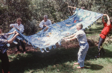
Slide - Photograph, Jacky Talbot, River of Life: Eltham Peace Banner, Sep 1986
A River of Life: Eltham Peace Banner 1986 The Hiroshima Day Banner was conceived by Shire of Eltham Artist in Residence, Jacky Talbot and a number of other Eltham women as part of the “As We Are” community banner project. The women wanted to do something for Hiroshima Day and suggested that a workshop be set aside to make a banner. The group promoted it at the new Community Notice Board (Arthur Street and Main Road) on Hiroshima Day (August 6) and were photographed by the local newspaper publicising the group and drawing wider community attention to the remembrance of the day. Jacky Talbot, led the team who produced the banner, approximately 4.5 metres by 1.5 metres, of sewn and painted Australian flora and fauna. Workshops were held at the Eltham Community Arts Centre at Meruka House. Peace Banner Group members included Laurel Eckersall, Anne Laurence, Betty Johnson, Margaret Johnson and Joan Maclagan. One of the creators, Joan Maclagan, further gave expression in verse – Banner for Peace The 'River of Life' with about 30 other banners went on display in the “As We Are” exhibition held at the Eltham Community Centre on 9 October 1986, previewed by the Member for Greensborough, Ms Pauline Toner, and Eltham Shire President, Mr Bob Manuell. The full display continued in Woolworths (now Coles) Arcade. The banner was also carried by the group in the 1986 Eltham Festival Grand Parade on November 8, along with other group banner projects including that of the Eltham District Historical Society, after which they were displayed in the Shire of Eltham’s tent in Alistair Knox Park.betty johnson, eltham peace banner, hiroshima day banner, laurel eckersall, "as we are" community banner project, banner project, river of life banner, margaret johnson, meruka house, community arts centre, jacky talbot, eltham shire council artist in residence -
 Eltham District Historical Society Inc
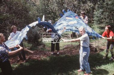
Slide - Photograph, Jacky Talbot, River of Life: Eltham Peace Banner, Sep 1986
A River of Life: Eltham Peace Banner 1986 The Hiroshima Day Banner was conceived by Shire of Eltham Artist in Residence, Jacky Talbot and a number of other Eltham women as part of the “As We Are” community banner project. The women wanted to do something for Hiroshima Day and suggested that a workshop be set aside to make a banner. The group promoted it at the new Community Notice Board (Arthur Street and Main Road) on Hiroshima Day (August 6) and were photographed by the local newspaper publicising the group and drawing wider community attention to the remembrance of the day. Jacky Talbot, led the team who produced the banner, approximately 4.5 metres by 1.5 metres, of sewn and painted Australian flora and fauna. Workshops were held at the Eltham Community Arts Centre at Meruka House. Peace Banner Group members included Laurel Eckersall, Anne Laurence, Betty Johnson, Margaret Johnson and Joan Maclagan. One of the creators, Joan Maclagan, further gave expression in verse – Banner for Peace The 'River of Life' with about 30 other banners went on display in the “As We Are” exhibition held at the Eltham Community Centre on 9 October 1986, previewed by the Member for Greensborough, Ms Pauline Toner, and Eltham Shire President, Mr Bob Manuell. The full display continued in Woolworths (now Coles) Arcade. The banner was also carried by the group in the 1986 Eltham Festival Grand Parade on November 8, along with other group banner projects including that of the Eltham District Historical Society, after which they were displayed in the Shire of Eltham’s tent in Alistair Knox Park.betty johnson, eltham peace banner, hiroshima day banner, laurel eckersall, "as we are" community banner project, banner project, river of life banner, margaret johnson, meruka house, community arts centre, jacky talbot, eltham shire council artist in residence -
 Eltham District Historical Society Inc
Slide - Photograph, Russell Yeoman, Para Road / Carter Street Bridge over the Plenty River, Briar Hill, c.Jul 1969
Bridge over the Plenty River at Briar Hill before widening and alterations. The Plenty River at Briar Hill represented the boundary between the Shire of Eltham and the Shire of Diamond Valley. The bridge was known as the Carter Street Bridge as prior to 1969 Para Road, Briar Hill became Carter Street, Greensborough across the river. It was at this time that the name Para Road was continued and replaced Carter Street.35mm colour positive transparency blue Agfacolour Service plastic mount1969-07, briar hill, carter street bridge, para road, para road bridge, shire of diamond valley, shire of eltham, bridge, plenty river, shire of eltham pioneers photograph collection