Showing 6747 items
matching gullies
-
 Stawell Historical Society Inc
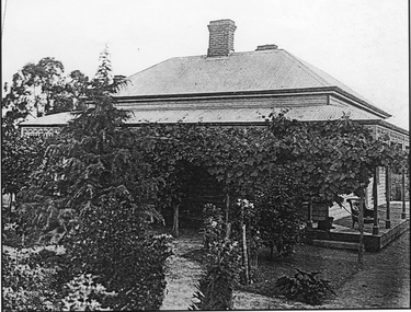
Photograph, Pierlots House Great Western 1920's
Charles Pierlot's house at Great Western. Build about 1900Garden Gully Rd, past Race Course, second house on left. Champagne maker for Hans Irvine. Photo possibly by Louis Grellet.winemaking -
 Whitehorse Historical Society Inc.
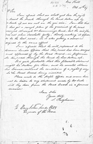
Letter - Correspondence, Roads, 10/10/1867
Letter from S. Padgham to Road Board Engineer dated 10 October 1867 re representations by Mr Cook about location of road relating to Mr Cumming's land and Marshall's Gully.marshall's gully, roads and streets, cook, william, cummings, (mr), padgham, silas -
 Mt Dandenong & District Historical Society Inc.
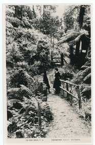
Photograph, Sassafras Gully, Victoria, c1920
The tourist track running alongside the creek from Sassafras Mechanics’ Hall to Emerald. In the early 1900s the track started at Rostrevor Guest House.Black and white copy of Rose Series Post card P. 74 showing two young women standing on a footbridge at Sassafras Gully. A set of steep steps can be seen above them.rose series, track, footbridge, bridge, sassafras -
 Southern Sherbrooke Historical Society Inc.
Tourism information booklet, "Visit The Dandenongs", 1939
photocopy of tourism booklet and typed letter from N.K.Gill, editor of Fern Tree Gully News, dated 8th June 1939, to Mr. A.R. Thomas, Selby, inviting interest in the publication of the booklet.tourism, dandenongs, tourist facilities -
 Falls Creek Historical Society
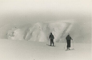
Photograph - Bogong Trip 1951- Cairn Gully and West Peak
MEYER COLLECTION - FALLS CREEK PHOTOS In 1947 a determined group of like-minded State Electricity Commission (SEC) staff including Ray Meyer, the chief surveyor of the Kiewa Hydro-Electric Scheme, had a common interest that revolved around the skiing potential of the snow-covered high plains which included what is now the resort of Falls Creek. The six SEC employees, Toni St Elmo, Ray Meyer, Jack Minogue, Lloyd Dunn, Adrian Ruffenacht and Dave Gibson (together with their families) banded together to secretly build a 'hut' that was the first ski lodge at Falls Creek. Using a road built in 1930s to gain access to Falls Creek, their hut project was carried out in secret as efforts by other skiers were blocked by H.H.C. Williams – the engineer in charge of the Hydro Scheme. In 1946 Ray Meyer made a trip to the Lands Office in Melbourne. He came away with a 99-year lease on three acres that was ideally suited for a hut designed by Lloyd Dunn. Adrian Ruffenacht (Design Engineer for the KHS) had suggested where the group should build because of easy access to a spring for water. Much of the building material required was scavenged from derelict huts on the high plains. Due to the need for secrecy, the determined group worked on the hut in the evenings and weekends to avoid detection. During the building period the group had met at Echidna Rock (now known as Eagle Rock) where Skippy St Elmo announced, "This is my favourite ‘Skyline’.” And so the first lodge in the area at Falls Creek Ski Resort came into existence. With the development of the International Poma in the 1970s, the Skyline Lodge, which was sited between the ski-lift’s pole one and pole two, was demolished. However, the legacy of Ray Meyer, Toni St Elmo, Jack Minogue, Lloyd Dunn, Adrian Ruffenacht and Dave Gibson and Skyline lives on in the vibrant atmosphere of Falls Creek Resort. The MEYER COLLECTION documents developments on the Kiewa Hydro Scheme and their life at Falls Creek from the mid 1930s to 1960s.This image is significant because it depicts aspects of the life of a pioneering family of Falls Creek and the founders of "Skyline", the first lodge at Falls Creek.Two black and white images taken on a trip to Mt. Bogong in 1951. 1. West Peak from Eskdale Saddle - Ray Meyer and Wal Johnson 2. Cairn Gully and West Peakfalls creek, bogong high plains, staircase spur memorial, ray meyer, wal johnson -
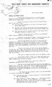 Falls Creek Historical Society
Document - Circular To Licence Holders & Others Interested In Committee Plans, 05.09.1963
Bob (Herman) Hymans (a former member of the Royal Netherlands Navy) was born in Bloemendaal, Holland on 30th September 1922. During World War II he fought against the Japanese in the Dutch East Indies (now Indonesia) and was imprisoned in Changi and on the Burma Railway. After gaining qualifications as a Ski Instructor, Bob arrived in Falls Creek in July 1950. Working as an Instructor and Supervisor at Bogong Lodge, Bob decided his future was in accommodation. He was successful in negotiating an indenture for land from the State Electricity Commission (SEC). It took Bob two years to build his Grand Coeur Chalet but, tragically, it was burned down in August 1961. Bob also built the first Chairlift in Australia. This was a single chairlift and the structure was built from wooden electricity poles. He was constantly full of new ideas and proposals for the village. Bob Hymans die on 7th July 2007. This Collection of documents and letters tells the story of Bob's endeavours to develop Falls Creek into the ski village it is today.This letter is significant because it documents developments made or endorsed by the Falls Creek Tourist Area Management Committee.A circular from the Management Committee outlining their plans for the development of the Falls Creek Tourist Area. This included completion of the Gully Chairlift, earmarking sites for cafes and restaurants and improvement in public facilities and medical services.falls creek tourist area management committee, falls creek administration -
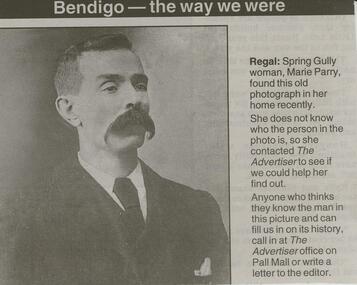 Bendigo Historical Society Inc.
Newspaper - JENNY FOLEY COLLECTION: REGAL
BHS CollectionBendigo Advertiser ''the way we were'' from Tuesday, December 30, 2003. Regal: Spring Gully woman, Marie Parry, found this old photograph in her home recently. The clip is in a folder.newspaper, bendigo advertiser, the way we were -
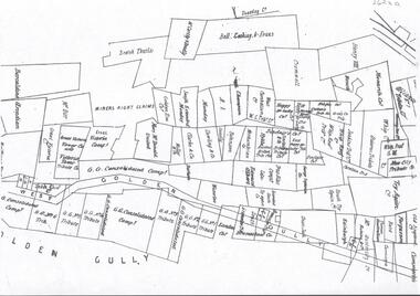 Bendigo Historical Society Inc.
Plan - GOLDEN GULLY CLAIMHOLDERS
BHS CollectionPlan showing names of claimholders in Golden Gully ( part section only). Mines include Glasgow Golconda Consolidated Company, GG Tribute, Victoria Console, Try Again, Bell, Cocking and Evans.bendigo, mining, golden gully -
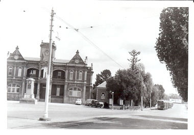 Bendigo Historical Society Inc.
Photograph - BASIL MILLER COLLECTION: TRAMS - EAGLEHAWK
Black and white photo showing trams on Sailors Gully Road, Eaglehawk. Eaglehawk Town Hall and War Memorial on left, and 3 Bogie trams on right. Number 'C922' stamped on the back of photo.basil miller, bendigo trams -
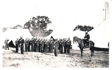 Hume City Civic Collection
Photograph
Military encampments took place in Canon Gully during the 1860s and the 1870s on property which was owned by the Clarke family. The Volunteer Militia was part of Victoria's defence capabilities until it was disbanded in 1883.A black and white photograph of 21 soldiers dressed in Nineteenth Century military uniforms standing in front of pitched tents with another soldier on the RHS sitting astride a horse.canon gully, george evans collection -
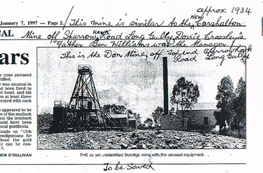 Bendigo Historical Society Inc.
Newspaper - LONG GULLY HISTORY GROUP COLLECTION: THE DON MINE
Copy of a newspaper article dated 7/1/1997. Photo shows a photo of a mine. Printed under the photo is: The as yet unidentified Bendigo mine with the unusual equipment. In the photo is the poppet head, chimney, buildings and some gum trees. Written at the top of article is: This mine is similar to the New Carshalton Mine Approx 1934 off Sparrow Hawk Road Long Gully. Dorrie Crossley's Father Ben Williams was the Manager. This is the Don Mine, off Top end Sparrowhawk Road Long Gully.bendigo, history, long gully history group, the long gully history group - the don mine, carshalton mine, dorrie crossley, ben williams, matthew o'sullivan -
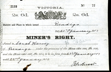 Bendigo Historical Society Inc.
Legal record - WES HARRY COLLECTION: THREE MINER'S RIGHT / RESIDENCY PERMITS
The Miner’s Right has a long history in Australia. Still in use today, it was first established in Victoria in 1855, as a replacement for the Gold License (which had been introduced in Victoria in 1851). The Miner’s Right was subsequently adopted by other Australian colonies. Unlike the Gold License, the early Miner’s Right, in addition to the right to prospect for gold, also carried with it certain other advantages, such as property rights and voting rights. The Miner’s Right came about as a recommendation of a government-appointed commission, which had been appointed on 1854 to look into the troubles on the Victorian goldfields, especially regarding the Eureka Rebellion.Three Miner's Rights / Residency Permits for leases on the corner of Holdsworth Road and Wood Street, Long Gully, Bendigo (Area known as American Gully - downstream of the American Mine): a and b No 72 Sarah Harvey, dated 23/01/1913 c and d No 23148 Evalina Gifford Vivian Harvey, dated 14/09/1926 e and f No 23149 Thomas George Harvey, dated 14/09/1926 Issued by the Victorian Government at a cost of two shillings and six penceVictorian State Governmentwes harry collection, miner's right, bendigo, history, long gully bendigo -
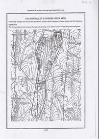 Bendigo Historical Society Inc.
Document - DIAMOND HILL, GOLDEN GULLY COSERVATION AREA
Map of Golden Gully conservation area comprising Glasgow and Golconda Consolidated, Glasgow Reef Company (Golden Gully) and New Napoleon. The area is significant because it contains the 'best evidence for hydraulic sluicing on the field as well as several early reef mining sites' On top of page 'Eaglehawk & Bendigo Heritage Study, Significant areas' Mines marked on page: Goldfields Extended shaft South Concord shaft Concord shaft Morning Light shaft Hansel and Mundy shaftbendigo, mining, golden gully -
 Bendigo Historical Society Inc.
Document - ''THE CHINESE'': HISTORY TUTORIAL PAPER BY WENDY ALLAN
''The Chinese'' - typed 8 paged History tutorial paper by Wendy Allan (no date or other information). Covers - early (pre discovery of gold) use of Chinese ('coolie) labour for farming purposes; gold- era Chinese and 'agents'; overland from Robe; attitudes to Chinese; Chinese camps in Bendigo ( Ironbark; White Hills; Back Creek; Charcole Gully; Kangaroo Flat; Long Gully; Peg Leg); crime; resentment; post-alluvial;developments union exclusion of Chinese. Bibliography.Wendy Allanbendigo, chinese, history, labor shortage. chinese labor. asiatic coolie-labour. captain king. governer gipps. ironbark. white hills. back creek. charcoal gully. kangaroo flat. long gully. peg leg. -
 Bendigo Historical Society Inc.
Photograph - LONG GULLY HISTORY GROUP COLLECTION: UNVEILING MINING MONUMENT
Page with three black and white photos, Two of them have four men and a lady and the third one is the same people standing behind and to the side of a little bench. The names of the people are, from left, John Bolitho, Cr Darrel McClure, George Ellis and Carol Rasmussen at the unveiling of the Long Gully Mining Monument. (Names from same photo in Newsletter June 2003 - 11010.214). Fixed to the paper is a nashuatec MF2HD disc with Miners Monument Long Gully 1 & 2.bendigo, history, long gully history group, the long gully history group - unveiling mining monument, nashuatec mf2hd disc, miners monument long gully -
 Bendigo Historical Society Inc.
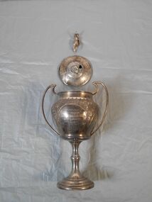
Award - Cricket Trophy
Long Gully History Group Collection: Interchurch Athletics League Cricket Trophy A metal cricket trophy in the form of a cup with two handles. The cup has a fitted lid topped with an ornament that has been broken off and damaged. The ornament is in the form of a classical figure. The figure is missing its feet and one hand. Inscription on the front reads 'Interchurch Athletic League, Long Gully Methodist Cricket Club, Outright Winners, Seasons 1923-24, 24-25, 25-26,26-27.bendigo cricket, cricket trophy, long gully methodist cricket club -
Bendigo Historical Society Inc.
Document - MINING REPORTS - MAP OF PART OF THE BENDIGO GOLDFIELD INCLUDING WHITE HILLS AND EAGLEHAWK
BHS CollectionMap of part of the Bendigo Goldfield including White Hills and Eaglehawk. Map shows reef lines, gullies, railway line, tram route, type of rock, name of mine, Calls and Dividends. Also Deepest Mine Victoria Quartz 4614 ft. Names of Mines are Garden Gully United, Great Ext'd Hustlers, Johnson's Reef, South New Moon, New Moon, Catherine Reef, Virginia, Central Red White & Blue, Ironbark, Kock's Pioneer, Carlisle and the Hercules & Energetic.document, gold, mining reports, mining reports, map of part of the bendigo goldfield including white hills and eaglehawk, pabst bendigo goldfield, garden gully united, great ext'd hustlers, johnson's reef, south new moon, new moon, catherine reef, virginia, central red white & blue, ironbark, kock's pioneer, carlisle, hercules & energetic. victoria quartz -
 Bendigo Historical Society Inc.
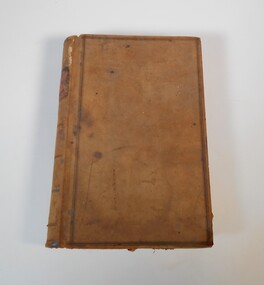
Administrative record - Truscott collection: grocer's day book
Anthony Truscott (1856 -1913) was born in Cornwall. He established a grocery store in Havilah St., Long gully and shortly before his death he handed the business to his so Anthony.Grocer's daybook. The book has a red cover and brown spine. It has 514 pages, used by the storekeeper to record the purchases made by customers. The book covers the years from 1906 to 1912."Ledger" on the spinegrocer, ledger, truscott -
Bendigo Historical Society Inc.
Document - Johnny Greenfield Gill, abt 1900-2010
John Greenfield Gill (1875 - 29/6/1927) married Alberta Jennings Marshall in 1898. He was the mining manager of the Unity Mine in Long Gully and was President of the Mine Manager Association in 1918.Diary of a New Chum, Johnny Greenfield Gill. Contains eight photocopies (B and W) describing his journey to Australia from Wales, Aged 19 years in 1892; also a copy of his ticket on the "Orient" steam ship.history, bendigo, johnny greenfield gill, orient line -
 Bendigo Historical Society Inc.
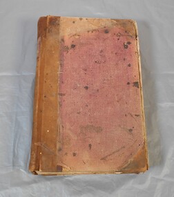
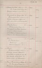
Financial record - Share register of the Spring Gully Freehold mine
The register records the purchases and sales of shares in the Spring Gully Freehold mine company. Individual names are listed and the date of purchase and sale are recorded against the names. The dates covered are fom 1900 to 1914Large share register book. Brown hardcover with the words ''share register'' printed on the spine. The book has 251 double pages, only the first 73 are used. share register, mining, spring gully freehold -
 Bendigo Historical Society Inc.
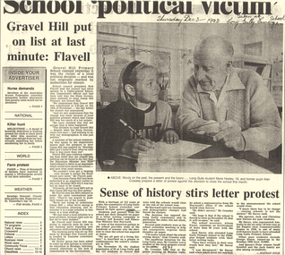
Newspaper - LONG GULLY HISTORY GROUP COLLECTION: GRAVEL HILL PRIMARY SCHOOL
Copy of an article from the Bendigo Advertiser Dec 3 - 1992 mentioning the closure of the Gravel Hill and Long Gully Primary Schools. The column about the Gravel Hill Primary School mentions that the Camp Hill School was the one that was going to close and then it was changed to close the Gravel Hill Primary School. The other article titled Sense of history stirs letter protest mentions the Long Gully Primary School fight to stay open. A photo accompanying the article shows a Long Gully student Marie Hooley writing a letter of protest. She is being assisted by former pupil Alan Crossley. Also mentioned is the school secretary, Aileen Ewart and former students Jack Davey, Jack and Christina (nee Sutton) Davey, George Ennor, Geoff Grenfell and the Jack Family. Article written by Nathan Dole.bendigo, history, long gully history group, the long gully history group - gravel hill primary school, rob flavell, education department, camp hill primary, don hayward, bendigo city council, chris stoltz, marie hooley, alan crossley, jeff kennett, aileen ewart, jack davey, jack and christina (nee sutton) davey, george ennor, geoff grenfell, jack family, nathan dole -
Bendigo Historical Society Inc.
Document - LYDIA CHANCELLOR COLLECTION: BENDIGO METHODIST CHURCHES PLAN 1905 AND CHURCH OFFICIALS, 1905
LYDIA CHANCELLOR COLLECTION: Bendigo Methodist Churches Plan 1905 and church officials Quarterly Pastoral Visitation of Classes Circuit plan for Forest St, Golden square, Eaglehawk West, Eaglehawk East, California Hill, California Gully, Long Gully, McKenzie St, Galvin St, Rowan St, Arnold St, Iron Bark, Buckly St, Specimen Hill, Quarry Hill, Bridge St, Retreat Road, Kangaroo Flat, Lockwood, East Shelbourne, White Hills, Epsom, Huntly, Bagshot, fosterville, Strathfieldsaye, Axe Creek, sheepwash, Nerring, Leichardt, Leichardt East, Marong, Golden Fleece, Golden Gully, Dowling St Mission, Benevolent Asylum, Hospital Income and Expenditure List of stewards Notices Pastorates Evangelistic Bandsbendigo, history, schooling -
 Bendigo Historical Society Inc.
Administrative record - Garden Gully and Moon Extended Gold Mines N.L. share transactions book, 1919 - 1920
Dark green soft cover book, maroon binding on spine. Book contains entries, on seven pages, detailing share transactions in the Garden Gully and Moon Extended Gold Mine. Entries date from October 1933 to October 1935. Inserted within the pages are following documents: 1. 2 documents from J.R. Ingram, 322 Collins Street, Melbourne, 21.1.35 relating to sale of shares of the Garden Gully and Moon Extended Gold Mines N.L. 2. 7 documents recording share sales by A.J. Taylor, member of the Bendigo Stock Exchange, on behalf ot the Garden Gully and Moon Extended Gold Mines N.L All documents address to McColl, Rankin and Stanistreet, View Point, Bendigo. Share register forms part of the Margaret Roberts Collection of Mining records.bendigo, margaret roberts, mine manager, paddy's gully shaft, , alfred bennett, north new moon company n.l., goldmining -
 Bendigo Historical Society Inc.
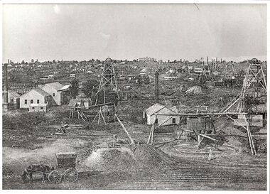
Photograph - BASIL MILLER COLLECTION: MINING LANDSCAPE - NEW CHUM GULLY, BENDIGO, 1860-70's
Black and white copy of landscape showing many poppet heads, mining activity in New Chum Gully, Bendigo. Fortuna Villa visible on ridge line, rear of photo. Horse and covered cart in foreground.unknownperson, individual, basil miller -
 Bendigo Historical Society Inc.
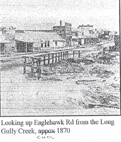
Photograph - LONG GULLY HISTORY GROUP COLLECTION: EAGLEHAWK ROAD FROM THE LONG GULLY CREEK
Photocopy of a photo with printing at the bottom: Looking up Eaglehawk Rd from the Long Gully Creek, circa 1870. The photo has buildings along the left of the road and in the foreground is a timber railing at the edge of a creek.bendigo, history, long gully history group, the long gully history group - eaglehawk road from the long gully creek circa 1870 -
 Bendigo Historical Society Inc.
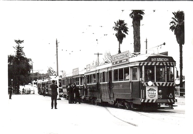
Photograph - BASIL MILLER COLLECTION: 4 TRAMS, EAGLEHAWK
Black and white photo of 4 trams, 3 bogie cars and 1 burnie safety car, stopped on Sailors Gully Road near Canterbury Park. No 18 Tram in lead, destined for Railway Station.person, individual, basil miller -
 Bendigo Historical Society Inc.
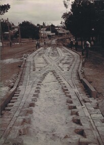
Photograph - UNKNOWN FAMILY COLLECTION: PHOTOGRAPH
Photograph - black and white. Tram tracks being laid. Also bluestone blocks are used. On back on photo is the word 'Long Gully ?'. Park on left of photo then a building in middle of photo says 'A.Cornwell, Baker'.W.H. Robinson, Mundy Street, Bendigo.place, transport, tram, tram tracks. long gully. -
 Bendigo Historical Society Inc.
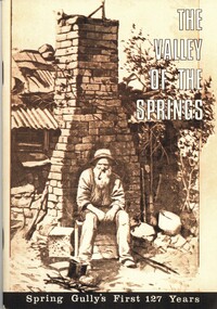
Book - THE VALLEY OF THE SPRINGS, 1970
The Valley of the Springs. Spring Gully's first 127 years. 40 pages with photographs and illustrations. Orange soft cover with centred drawing of a miner sitting in front of a chimney. Index compiled by Estelle Hewston. With Indexspring gully, celebration, 125th. anniversary -
Bendigo Historical Society Inc.
Document - BENDIGO & SANDHURST GOLD MINING COMPANIES FROM 1871, 1871-1950
Typed copy of the Bendigo & Sandhurst Gold Mining Companies From 1871. Vol 1 Victorian Government Gazettes. Eight pages. Includes Mine name, Reef/Gully, Place/Suburb, Mine Manager -
 Bendigo Historical Society Inc.
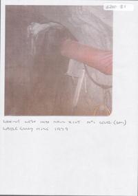
Photograph - KEN BICE COLLECTION: WATTLE GULLY GOLD MINE
Colour photograph, faded and laminated. Image shows underground tunnel with air line on RH side. On bottom of image:' looking west into main xcut No. 1 level (60m) Wattle Gully Mine 1979.'mining, underground equipment, wattle gully gold mine