Showing 831 items matching "land office"
-
 Ballarat Heritage Services
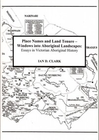
Book, Place Names and Land Tenure: Windows into Aboriginal Landscapes: Essays in Victorian Aboriginal History
Place Names and Land Tenure was published by BHS Publishing and written by Ian D. Clark. -
 Ballarat Heritage Services
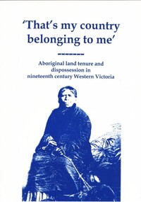
Book, Ian Clark, 'That's My Country Belonging to me': Aboriginal land tenure and dispossession in nineteenth century Western Victoria
'That's my Country Belonging to me' was published by BHS Publishing and written by Ian D. Clark.aboriginal history -
 Ballarat Heritage Services
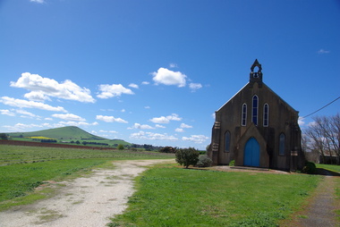
Photograph - Photograph - Colour, Smeaton Presbyterian Church, 2015, 18/12/2015
The Smeaton Presbyterian Church was built in 1859 of locally made brick, and opened in 1860. The building committee was . Messrs. John Hepburn, W. McAlpine, W. Anderson, S. Moore, W. H. Clarke and W. Miller. It cost an estimated 1,200 pounds, and was assisted by Captain John Hepburn who donated 5 acres of land and 150 pounds for the church. The rest was contributed by the settlers and their employees. Around 1890, the outside brickwork was given a coat of cement, which has improved with age. In 1938 the grey stained exterior was described as “not altogether displeasing”. Colour photographs of Smeaton Presbyterian Church.smeaton, smeaton presbyterian church, churches, kooroocheang -
 Ballarat Heritage Services
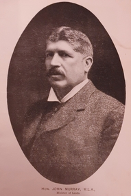
Photograph - Image - Black and White, Hon. John Murray, M.L.A, C1905
... Office goldfields land acts politician john murray land act Image ...Image of John Murray, Victorian Minister of Agriculture.land acts, politician, john murray, land act -
 Ballarat Heritage Services
Photograph - Image - Black and White, A Wine Cellar, C1905
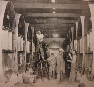
Image of a wine cellar in Victoria.politician, john murray, land acts, politician, land acts, john murray, wine -
 Ballarat Heritage Services
Image - Black and White, A Mallee Railway Station, C1905
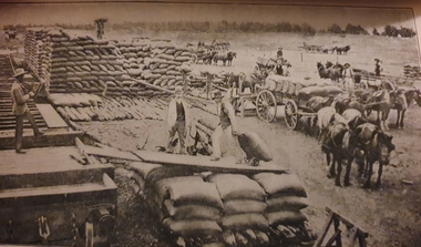
... Office goldfields politician land acts john murray wine mallee ...Image of a Mallee Railway station.politician, land acts, john murray, wine, mallee -
 Ballarat Heritage Services
Photograph - Image, Guildford, Victoria, 1867
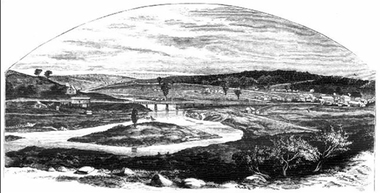
Black and white image of Guildford, near Castlemaine, VictoriaGUILDFORD Is a small township situated at the junction of Campbell's Creek and the Loddon. It is about seven miles from Castlemaine, on the road from that town to Ballaarat and Daylesford. The land near the Loddon is very rich, and as a large number both of theoretical and practical miners believe that a rich goldfield underlies the surface basalt, there is every probability of Guildford being ere an important goldfield. A large area of land in the neighbourhood has been already worked, principaIy by Chinamen, who until very recently mustered in great force in the locality. (Illustrated Adelaide Post, 23 March 1867)guildford, loddon river -
 Ballarat Heritage Services
Photograph, Clare Gervasoni, Apollo Bay, Victoria, 24/01/2022
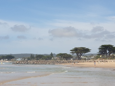
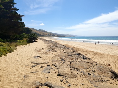
In 2021, the Department of Environment, Land, Water and Planning (DELWP) constructed two new groynes and a section of rock seawall at Apollo Bay to help manage the impacts of coastal erosion. The new 70-meter-long rock groynes run perpendicular to the shoreline and be located just south of the Milford St revetment and to the south of Milford Creek. Sections of rock seawall will be constructed between the two Groynes with an aim to protect the dune, walking path, cypress trees and road from erosion. Colour photograph of a coastal scene at Apollo Bay, featuring new rock groynes to protect the Great Ocean Road from erosion. apollo bay, beach, coast, groyne, rockwall -
 Ballarat Heritage Services
Photograph, Clare Gervasoni, Apollo Bay, Victoria, 24/01/2022
In 2021, the Department of Environment, Land, Water and Planning (DELWP) constructed two new groynes and a section of rock seawall at Apollo Bay to help manage the impacts of coastal erosion. The new 70-meter-long rock groynes run perpendicular to the shoreline and be located just south of the Milford St revetment and to the south of Milford Creek. Sections of rock seawall will be constructed between the two Groynes with an aim to protect the dune, walking path, cypress trees and road from erosion. Colour photograph of a coastal scene at Apollo Bay, featuring new rock wall and groynes to protect the Great Ocean Road from erosion. apollo bay, beach, coast, groyne, rockwall -
 Ballarat Heritage Services
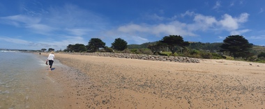
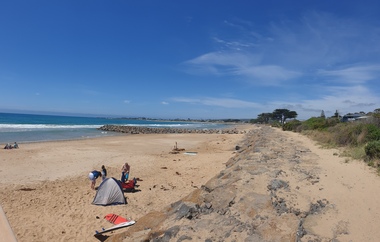
Photograph, Clare Gervasoni, Sea Wall at Apollo Bay, Victoria, 24/01/2022
In 2021, the Department of Environment, Land, Water and Planning (DELWP) constructed two new groynes and a section of rock seawall at Apollo Bay to help manage the impacts of coastal erosion. The new 70-meter-long rock groynes run perpendicular to the shoreline and be located just south of the Milford St revetment and to the south of Milford Creek. Sections of rock seawall will be constructed between the two Groynes with an aim to protect the dune, walking path, cypress trees and road from erosion. Colour photograph of a coastal scene at Apollo Bay, featuring new rock wall and groynes to protect the Great Ocean Road from erosion. apollo bay, beach, coast, groyne, rockwall, sea wall -
 Ballarat Heritage Services
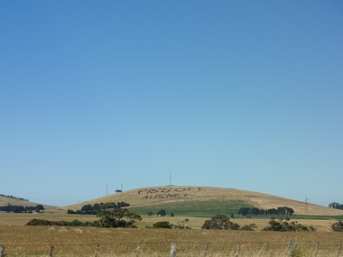
Plaque, Piss Off Ausnet, Mt Prospect
Angry farmers protest Angry farmers protest against huge power transmission land which will destroy pristine views and make some agricultural land unusable. A rural landscape at Mt Prospect on which has been plouhed the words 'Piss Off Ausnet"piss off ausnet, newlyn, mt prospect -
 Ballarat Heritage Services
Book, Hepburn Shire Council Biodiversity strategy, 2018, 2018
48 Page report on biodiversity in the Victorian Shire of Hepburn. non-fictionbiodiversity, shire of hepburn, ricky nelson, dja dja wurrung, public land management, climate change, habitat corridors, biolink zones, weed management -
Ballarat Heritage Services
Book, Dja Dja Wurrung Dhelkunya Dja Country Plan, 2014-2034
non-fictiondja dja wurrung, dhelkunya, cultural heritage, bushtucker, medicine, rivers, waterways, self-determination, joint management, crown land, trent nelson, graham atkinson, native title, traditional owners -
Ballarat Heritage Services
Book, Dhelkunya Dja Joint Management Plan for the Dja Dja Wurrung Parks: Strategy, 2018
non-fictiondja dja wurrung, dhelkunya, cultural heritage, bushtucker, medicine, rivers, waterways, self-determination, joint management, crown land, native title, traditional owners, language -
Ballarat Heritage Services
Document, Helen Doyle & Context Pty Ltd, Moyne Heritage Study Stage 2 Vol 2, 2006
141 page heritage studymoyne, minhamite, port fairy, mt shadwell, mt rouse, mt napier, mt eccles, tower hill, dhauwurdwurrung, djabwurrung, giraiwurrung, caramut, james atkinson, special survey, william rutledge, yangery, land selection act, closer settlement, soldier settlement, framlingham, lime burning, atkinson’s belfast survey, belfast, killarney, crossley, aboriginal protectorate, lake condah, hexham, hexham common school, koroit convent, hurling, mile posts, kirkstall, ballyhurst, dundonnell, curdievale, ballangeich, hawkesdale, irish, scottish, aborigines, tower hill cemetery, st brigid’s catholic church -
 Ballarat Heritage Services
Photograph - Photograph - Colour, Clare Gervasoni, St Francis Xavier Chapel, Eganstown, 2021, 29/1/2021
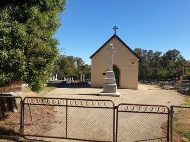
The St Francis Xavier Chapel and Catholic Cemetery was established on land donated by squatter John Egan.St Francis Xavier Chapel, the chapel in the Eganstown Catholic Cemetery. The grave stone at the front of the church is for John Egan. st francis xavier chapel, eganstown, 1999, eganstown catholic cemetery, eganstown, church, chapel, cemetery, john egan -
 Ballarat Heritage Services
Photograph - Map, A Sketch from Dalyrmples Map of 1767, 1767
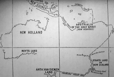
Copy of a map showing the coast that was known during the voyge of the Endeavour, and the first map that marks Torres track.map, new holland, hollandia nova, isaac de graaff, new guinea, australia of the holy spirit, papua, new hebrides, new zealand, nuyts land, van dieman's land, tasman's track, torres -
 Ballarat Heritage Services
Photograph, L.J. Gervasoni, Cattle Race at the Ballarat Saleyards, 2008, 27/06/2008
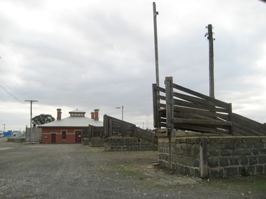
The last sale at the Delacombe Saleyards took place in December 2018. The closure comes after around 130 years after the parcel of land that is home to the Ballarat saleyards was permanently reserved from sale by then Colony of Victoria Governor, Sir Henry Brougham Loch, with advice of the Executive Council.Colour photographs of the Ballarat Sale yards, LaTrobe Street, Delacombe. ballarat saleyards, saleyards, cattle yards, cattlerace, agriculture -
 Ballarat Heritage Services
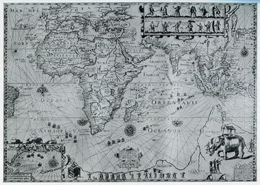
Map, Plancius's Map (Amsterdam), 1594, 1594
Copy of a Dutch map published in Amsterdam. showing a large stretch of outhern land called Terra sustralis Copy of a map from 'A Short HIstory of Australia' by Ernest Scott.map, plascius, placius's map, terra australis, dutch map -
 Ballarat Heritage Services
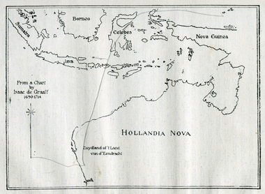
Photograph - Map, Map of New Holland from a chart by Isaac de Graaf (1690-1714), c1714
Copy of a map from 'A Short HIstory of Australia' by Ernest Scott.map, new holland, hollandia nova, isaac de graaff, new guinea, australia of the holy spirit, papua, new hebrides, new zealand, nuyts land, van dieman's land, tasman's track -
 Ballarat Heritage Services
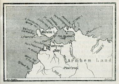
Map, Melville Island
Copy of a map from 'A Short History of Australia' by Ernest Scott.map, explorers, exploration, melville island, tiwi islands, arnhem land, palmerston, daly, croker island, bathurst island, pine creek, daly river -
 Ballarat Heritage Services
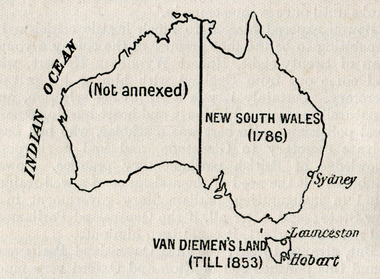
Map, Australian Colonies (States), c1918
Copy of a map from 'A Short History of Australia' by Ernest Scott published in 1918. map, australia, indian ocean, van dieman's land, tasmania, new south wales, sydney, western australia, perth, albany, launceston, hobart, south australia, melbourne, townsville, rockhampton, brisbane, northern territory, queensland -
 Ballarat Heritage Services
Photograph, Clare Gervasoni, Entrance to Merino Downs Henty, 2015, 22/12/2015
Merino Downs was the property of early squatters the Henty brothers. Pentonvillian Axile George Ind worked for the Henty's at Merino Downs after his arrival at Portland in 1845. The Henty Girls were witnesses to his marriage. Colour photograph of land around Merino Downs, Hentyhenty, merino downs, henty brothers, george ind -
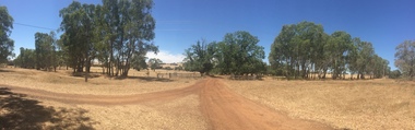 Ballarat Heritage Services
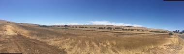
Photograph, Clare Gervasoni, Entrance to Merino Downs, Henty, 2015, 22/12/2015
Merino Downs was the property of early squatters the Henty brothers. Pentonvillian Exile George Ind worked for the Henty's at Merino Downs after his arrival at Portland in 1845. The Henty daughters were witnesses to his marriage. Colour panoramic photograph of land around Merino Downs, Henty, Victoriahenty, merino downs, henty brothers, george ind, henty daughters, panorama -
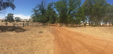 Ballarat Heritage Services
Photograph, Clare Gervasoni, Entrance to Merino Downs Henty, 2015, 22/12/2015
Merino Downs was the property of early squatters the Henty brothers. Pentonvillian Axile George Ind worked for the Henty's at Merino Downs after his arrival at Portland in 1845. The Henty Girls were witnesses to his marriage. Colour photograph of land around Merino Downs, Hentyhenty, merino downs, henty brothers, george ind -
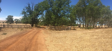 Ballarat Heritage Services
Photograph, Clare Gervasoni, Entrance to Merino Downs Henty, 2015, 22/12/2015
Merino Downs was the property of early squatters the Henty brothers. Pentonvillian Axile George Ind worked for the Henty's at Merino Downs after his arrival at Portland in 1845. The Henty Girls were witnesses to his marriage. Colour photograph of land around Merino Downs, Hentyhenty, merino downs, henty brothers, george ind -
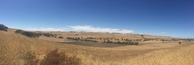 Ballarat Heritage Services
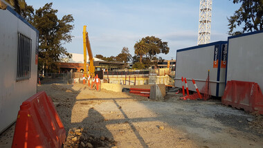
Digital photograph, Lisa Gervasoni, Derby Street Redevelopment, 2017, 2017
Colour photograph of a block of land being redeveloped in Kew, Victoriabuilding, derby street, kew, residential, apratment, construction, redevelopment, overdevelopment