Showing 44512 items
matching land-conservation-east-gippsland
-
 Orbost & District Historical Society
black and white photograph, first half 20th century
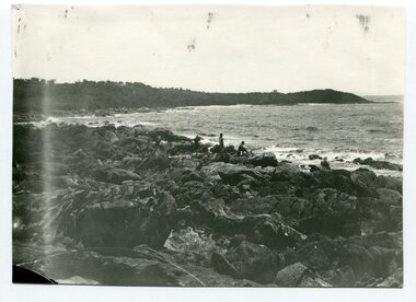
This photograph is of Cape Conran in Far East Gippsland.Cape Conran has always been a popular fishing destination for Orbost people. This photograph is a pictorial record of that recreational activity in the early20thy century.A black / white photograph of two men fishing from rocks with the ocean in the background. There are other people standing and sitting on the rocks.on back - "Cape Conran"cape-conran-fishing -
 Greensborough Historical Society
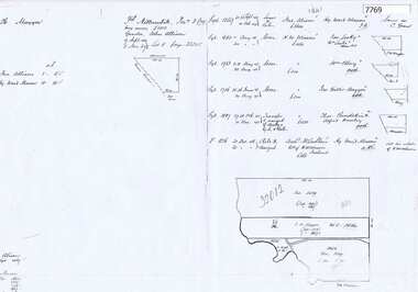
Document - Certificate of Title, Alison land, 1840o
Land originally granted to John Alison 09/09/1840. Shows chain of ownership from Alison to Lecky, Mayger (Magyar) and Blay; Lecky to Charles Buck; Mayger to Whatmough.Shows part of the chain of ownership of this parcel of land in Greensborough.4 pages. Copies of land titles and associated documentsSome annotations by Noel Withersland titles - greensborough, mayger family, whatmough family -
 Ballarat Heritage Services
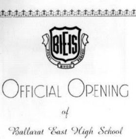
Program, Ballarat East High School, Official Opening Program, 1961, 1961
Ballarat East High School Official Opening Programballarat east high school, opening, education -
 Ballarat Heritage Services
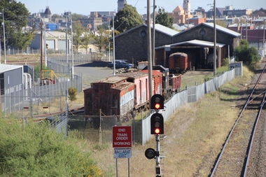
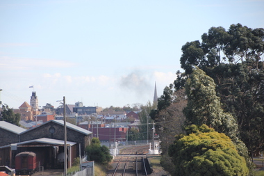
Photograph - Photograph - Colour, L.J. Gervasoni, Ballarat from Ballarat East Rail Overpass, 2016, 15/05/2016
Colour photographs showing the train turntable at Ballarat East.ballarat east railway, ballarat, railway -
 Ballarat Heritage Services
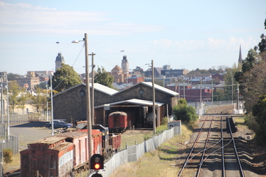
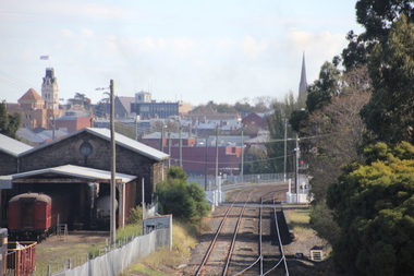
Photograph - Colour, L.J. Gervasoni, Ballarat East Station, 2016, 15/05/2016
Colour photographs showing Ballarat East Railway station.ballarat east railway, ballarat -
 Ballarat Heritage Services
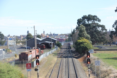
Photograph - Colour, L.J. Gervasoni, Ballarat East Station, 2016, 15/05/2016
Colour photographs showing Ballarat East Railway station.ballarat east railway, ballarat, ballarat east work sheds -
 Ballarat Heritage Services
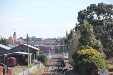
Photograph - Colour, L.J. Gervasoni, Ballarat East Station, 2016, 15/05/2016
Colour photographs showing Ballarat East Railway station.ballarat east railway, ballarat -
 Ballarat Heritage Services
Photograph - Colour, L.J. Gervasoni, Ballarat East Station, 2016, 15/05/2016
Colour photographs showing Ballarat East Railway station.ballarat east railway, ballarat -
 Ballarat Heritage Services
Photograph - Colour, L.J. Gervasoni, Ballarat East Station, 2016, 15/05/2016
Colour photographs showing Ballarat East Railway station.ballarat east railway, ballarat -
 Ballarat Heritage Services
Photograph - Colour, L.J. Gervasoni, Ballarat East Station, 2016, 15/05/2016
Colour photographs showing Ballarat East Railway station.ballarat east railway, ballarat -
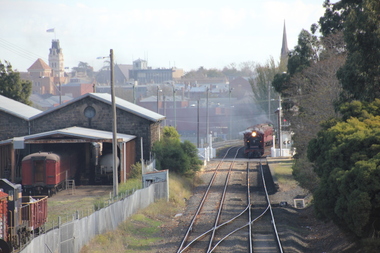
 Ballarat Heritage Services
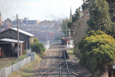
Photograph - Photograph - Colour, L.J. Gervasoni, Ballarat East Station with Steam Train on the Track, 2016, 15/05/2016
Colour photographs showing Ballarat East Railway station.ballarat east railway, ballarat, steam train -
 Ballarat Heritage Services
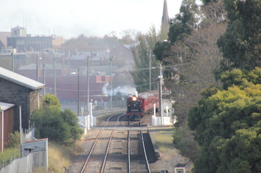
Photograph - Colour, L.J. Gervasoni, Ballarat East Station with Steam Train on the Track, 2016, 15/05/2016
Colour photographs showing Ballarat East Railway station.ballarat east railway, ballarat -
 Ballarat Heritage Services
Photograph - Colour, L.J. Gervasoni, Ballarat East Station with Steam Train on the Track, 2016, 15/05/2016
Colour photographs showing Ballarat East Railway station.ballarat east railway, ballarat -
 Ballarat Heritage Services
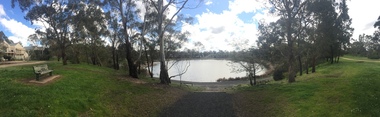
Photograph - Colour, Lake Esmond, Ballarat East, 2016, 17/09/2016
Colour panoramic views of Lake Esmond in Ballarat East lake esmond, james esmond, ballarat east, pre-olympic swimming pool -
 Ballarat Heritage Services
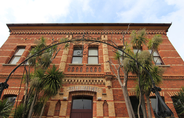
Photograph - Colour, Former Ballarat East Library, 2015, 07/04/2015
Brick building in Ballarat East built as the municipal library.former ballarat east library, ballarat east -
 Ballarat Heritage Services
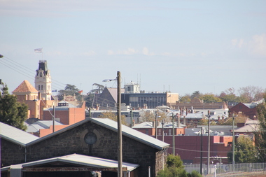
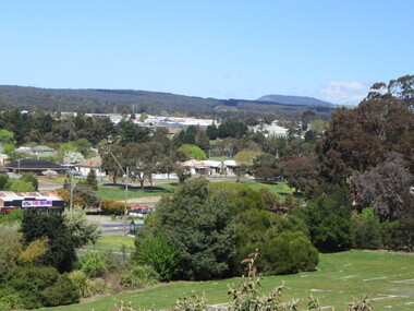
Photograph - Colour, Clare Gervasoni, Ballarat East from the Gold Museum, 2017, 11/2017
Colour photograph of Ballarat East from the Gold Museum.ballara east -
 Federation University Historical Collection
Photograph - Photograph - Black and White, Paul Lambeth, Ballarat Fire Brigade (East), 1992
black and white photograph of a woman standing in the shadow of the Ballarat Fire Brigade, Ballarat East.in pencil on verso "Ballarat Fire Brigade (East)"ballarat, fire brigade, woman, ballarat fire brigade, ballarat east fire brigade, east ballarat heritage project, paul lambeth -
 Kew Historical Society Inc
Work on paper - Sepia Wash & Ink, G B Richardson, Creek and Old Watering Stage, on the Yarra, East Collingwood, 1854, 1854
Blind Creek was located between the Abbotsford Convent and what is now the Collins Bridge in Studley Park. In an 1858 map of East Collingwood by Clement Hodgkinson, in the State Library of Victoria, one can see how the creek was originally a significant landmark in Collingwood; remaining vacant land until a barrel drain enclosed it. The area was later filled in, surveyed and developed. The position where Blind Creek entered the Yarra was in the immediate vicinity of Hodgson’s Punt, which had linked Kew to the other side of the Yarra from 1839. The Punt was purchased by the Colonial Government in 1852 and was in use until the opening of the Studley Park Road (Johnston Street) Bridge in 1858 made its continued use redundantThe point of view selected by the artist for the watercolour is from the banks of Blind Creek in East Collingwood, looking across the Yarra to the Kew side of the river.Inscribed verso 'Creek and Old Watering stage, on the Yarra East Collingwood 1854 / Trees, stage, &c have long since disappeared / [Artist Signature] / FT 110 / Creek itself now being filled in 1903.gb richardson, blind creek - abbotsford, yarra river - abbotsford (vic) - kew (vic), colonial artists, australian art - 19th century, george bouchier richardson -
 Ringwood and District Historical Society
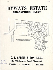
Flyer, Land Sale Brochure, Byways Estate Ringwood East - 1965 Release
Refer also to Reg. No. 5113 for Byways Estate 1967 release, and Reg. No. 5114 for Byways Estate 1970 release.Double-sided real estate notice showing subdivision location with layout of streets and propertiesSubdivision plan includes Alexandra Road, Isabel Avenue, Byways Drive and Buronga Avenue. (Agent) C.E. Carter & Son R.E.S.I. 126 Whitehorse Road, Ringwood (Telephone) 876024, 876830, 8702519. -
 Ringwood and District Historical Society
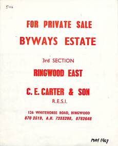
Flyer, Land Sale Brochure, Byways Estate Ringwood East - 3rd Section released 1967
Refer also to Reg. No. 5110 for Byways Estate 1965 release, and Reg. No. 5114 for Byways Estate 1970 release.Double-sided real estate notice showing subdivision location with street and property layout, with separate A4 typewritten price listSubdivision plan includes Byways Drive, Buronga Avenue, Hender Street, Lester Avenue and Jess Court. (Agent) C.E. Carter & Son R.E.S.I. 126 Whitehorse Road, Ringwood (Telephone) 870 2519, A.H. 723 3298, 878 2648 -
 Ringwood and District Historical Society
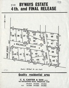
Flyer, Land Sale Brochure, Byways Estate Ringwood East - 4th and Final Release - 1970
Refer also to Reg. No. 5110 for Byways Estate 1965 release, and Reg. No. 5113 for Byways Estate 1967 release.Single page advertisement showing layout of the last stage of the Byways Estate subdivisionSubdivision plan includes Hume Street, Walhalla Drive and Hender Street. (Agent) C.E. Carter & Son R.E.S.I. 126 Whitehorse Road, Ringwood, 3134 (Telephone) 870 2519, 870 6830, 870 6024, A.H. 723 3298, 870 4604, 870 6454 -
 Ringwood and District Historical Society
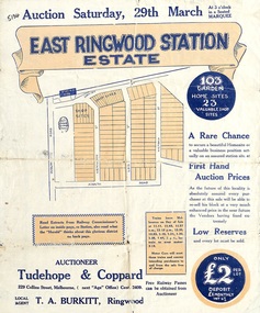
Flyer, Land Sale Auction Brochure, East Ringwood Station Estate - 1924
Bi-folded double sided sheet with yellow and blue print advertising auction of retail and residential allotments on Saturday, 29 March (1924), including details of subdivision features and local facilities. Subdivision includes Station Street, Wenwood Street, Lois Street, Victoria Street. Auctioneer - Tudehope & Coppard, 229 Collins Street, Melbourne, Tel. Central 2409, in conjunction with local agent, T.A. Burkeitt, Ringwood, Tel. Ringwood 157. -
 Ringwood and District Historical Society
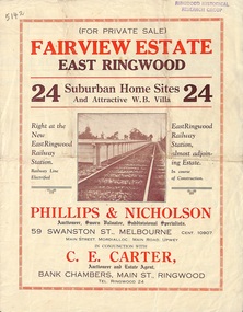
Flyer, Land Sale Brochure, Fairview Estate, East Ringwood, Vic. - circa 1925
Bi-folded single sheet advertisement for private sale of residential allotments, including subdivision features and local facilitiesSudivision includes Eastfield Road, Margaret Street and Patterson Street. Local Agent - C.E. Carter, Bank Chambers, Main St., Ringwood. Tel. Ringwood 24. -
 Ringwood and District Historical Society
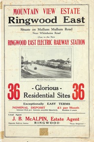
Flyer, Land Sale Brochure, Mountain View Estate, Ringwood East, Vic. - 1923
Bi-fold advertisement for sale of residential allotments, including photographs, map, and summary of subdivision features and local facilities. Undated handwritten notation reads "streets don't exist today".Subdivision layout includes Mullum Mullum Road, Rangeview Avenue, Press Avenue, and Mountview Avenue. Local Agent - J.B. McAlpin, Opposite Railway Station, Ringwood, Phone Ringwood 7. Vendor - T.J. Press, Builder, "Monterey", Second Avenue, Kew, Telephone Haw. 3428. -
 Ringwood and District Historical Society
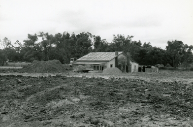
Photograph, East side of Wantirna road between Taurus Restaurant and Dandenong Creek. The land has been raised level with fill, 1989
Digital photographA week after the photo was taken, the house was gone. In the 1950s, the council employed a man with horse and cart to chip and clean the prefabricated gutters. He lived in this house. -
 Ringwood and District Historical Society
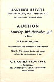
Flyer, Land Sale Auction Brochure, Salter's Estate, East Ringwood, Vic. - 1956
Folded single page advertising auction of allotments on Saturday, 10th November (1956), including layout of subdivision and terms of sale.Subdivision includes Railway Avenue, Nicholson Street, Althol Grove (later Morcom Avenue), Illoura Avenue, Tweed Street, Merry Street, and Dublin Road. (Agent) C.E. Carter & Son R.E.S.I., Auctioneer, 126 Whitehorse Road, Ringwood, Phone WU6024. -
 Ringwood and District Historical Society
Flyer, Land Sale Advertisement - Sunbeam Estate, East Ringwood, Victoria - circa 1930
Folded double-sided page advertising private sale of 48 residential allotments, with location map, terms of sale, and details of local features and services. Locality plan includes Holland Road, Everard Road, Sunbeam Avenue, Mount Dandenong Road, and Lilydale Road (later Old Lilydale Road). (Agents) Phillips & Nicholson, 59 Swanston Street, Melbourne, (Phone) Central 10907, in conjunction with C.E. Carter, Bank Chambers, Main Street, Ringwood, Telephone Ringwood 24. -
 Ringwood and District Historical Society
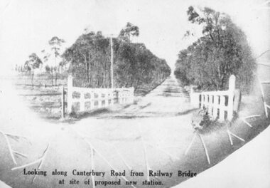
Photograph, Image used for land sale promotion of Coleman's Heathmont Estate, looking east along Canterbury Road, Heathmont, towards Bedford Road. Sale 15/12/1923 by Public Auction
Written on back of photograph, "Coleman's Heathmont Estate, looking towards Bedford Rd. Sale 15/12/1923 by Public Auction". -
 Ringwood and District Historical Society
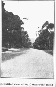
Photograph, Image used for land sale promotion of Coleman's Heathmont Estate, looking east along Canterbury Road, Heathmont. Sale 15/12/1923 by Public Auction
Catalogue card reads, "Coleman's Heathmont Estate - 1923. Sale 15/12/1923." -
 Brimbank City Council
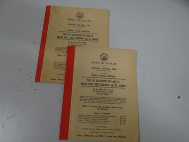
Land Sale Booklet x 2 (2 copies of the same booklet), Sale of allotments of land at Keilor East, West Essendon and St Albans 1954
land sale