Showing 3152 items matching "miles"
-
 Ringwood and District Historical Society
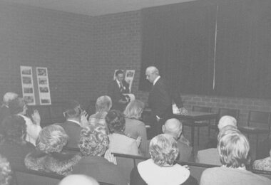
Photograph, 1979 Ringwood Historical Research Group 20th Annual General Meeting
Catalogue card reads, '1979 - Ringwood Historical Research Group 20th Annual General Meeting, Sept. 1979. Paddy Miles at centre C & D'. -
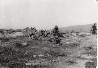 8th/13th Victorian Mounted Rifles Regimental Collection
Photograph - 8th LH outpost, 1918 circa
The 8th Light Horse Regiment was engaged in the battle to capture Turkish defences at Tel El Khuweifle 16 Kilometres north of Beersheba from 1 to 6 November 1917. Other units were drawn from Imperial Camel Corps, British Yeomanry Division, New Zealand Mounted Rifles and 53 Welsh Division. The 8th Light Horse Regiment AIF was raised at Broadmeadows Victoria in September 1914 under the command of Lieutenant Colonel Alexander White and formed part of the 3rd Light Horse Brigade. The regiment served at Gallipoli where in a courageous but ill-fated charge at the Nek on 7 August 1915 it suffered horrendous casualties including Lieutenant Colonel White. Rebuilt in Egypt under the command of Lieutenant Colonel Leslie Maygar VC the regiment went on the serve throughout the Middle East Campaign. Colonel Maygar died of wounds at Beersheba when the regiment was attacked by enemy aircraft while waiting to follow up the successful charge of the 4th LH Brigade on 30 October 1917. The 8th Light Horse AIF was disbanded in 1919, but soon after re-raised as the 8th (Indi) Light Horse in the Citizen Military Forces, superseding 16th (Indi) Light Horse.Part of a rare collection of photographs of 8th Light Horse Regiment AIF during WWI (1914-1918).Black and white photograph of two soldiers of the 8th Light Horse Regiment AIF wearing slouch hats and armed with rifles. They are near three figures wearing helmets lying on the ground, possibly men of the Imperial Camel Corps or British infantry. Below photograph "Stony desert landscape known as Khuweilfe ( Thirsty Ridge ), 8 miles north of Beersheba. Only had a little water hence the name",tel el khuweifle, 8th, light horse, world war one, wwi -
 Uniting Church Archives - Synod of Victoria
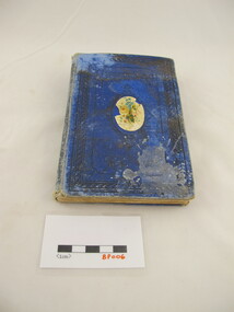
Book - Book prize, T. Nelson and Sons, The Olive-branch and other stories, 1879
Blue hard covered book with a paper floral decal at the centre of the front cover. The book has black text on the cover. 120 p.fictionwesleyan sabbath school wesley hill, f. shakesley, elizabeth miles -
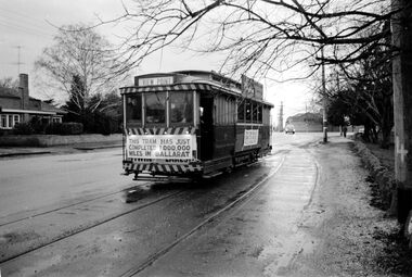 Ballarat Tramway Museum
Photograph - Digital image, Mal Rowe, 29/06/1968 12:00:00 AM
Yields information about the purported achievement of tram 27 reaching 1,000,000 miles and the TMSV Tour and the Lake View loop, showing its relationship with the Ballarat A power station and the removed set of points that were used to construct 0 road at the SEC depot in 1956.Digital image of a Black and white photograph of Tram 27 at the Lake View Loop in Wendouree Parade during the celebrations of the tram completing its "millionth" mile in Ballarat on Saturday 29 June 1968. Note that the south end points of the loop have been removed. The Ballarat A Power station fence is in the background. Tram showing "Special", has banner "This tram has just completed 1,000,000 (million) miles in Ballarat" on the front of the tram during the TMSV Celebratory tour. See also Reg Items 1878 and 7990 to 7995 for other photos of the day by Mal Rowe. Note: A review of the tram car mileages by Dave Macartney, showed that it was actually 900,000, due to a carryover error.trams, tramways, tmsv, million miles, lake view, wendouree parade, crossing loop, ballarat a power station, tram 27 -
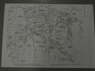 Kiewa Valley Historical Society
Maps - Squatting Runs of the Murray District 1848 x2, July 26,1848
The Port Phillip Gazette was the second newspaper published in Melbourne, in the then Port Phillip district, now Victoria. In 1948 it was published bi-weekly.The map shows the original names of squatters along the Kiewa River. The names of the district are mostly current today although some are spelt differently.2 copies - 1 laminated & 1 paper of the map of "Squatting Runs of the Murray District 1848." The area is recorded (eg. Tawanga, Dederang, Gundowring, Kergunia, Merrimarenbung all along the Kiewa River) under which the names of the squatter is recorded, the number of acres and the licence number. Scale is 8 miles to the inch.squatting runs; kiewa valley; port phillip district; -
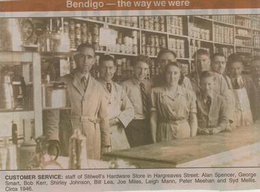 Bendigo Historical Society Inc.
Newspaper - JENNY FOLEY COLLECTION: CUSTOMER SERVICE
Bendigo Advertiser ''The way we were'' from 2001. Customer service: staff of Stilwell's Hardware store in Hargreaves Street: Alan Spencer, George Smart, Bob Kerr, Shirley Johnson, Bill Lea, Joe Miles, Leigh Mann, Peter Meehan and Syd Mellis. Circa 1946. The clip is in a folder.newspaper, bendigo advertiser, the way we were -
 Bendigo Historical Society Inc.
Map - STATE RIVERS AND WATER COMMISSION : COLIBAN DISTRICT IRRIGATION AND TOWN SUPPLY CHANNELS, 30/11/1956
State Rivers and Water Supply Commission. Foolscap-size map. Title : Coliban district Plan showing Irrigation and Town Supply Channels. The map covers the area from Raywood to Guildford. Scale : 1 inch to 4 miles. Dated 30/11/56, number 5,491 in bottom right corner.state infrastructure, water supply, coliban system, state rivers and water supply commission. coliban system. -
 Bendigo Historical Society Inc.
Map - CAMPBELL COLLECTION: BENDIGO AND DISTRICT MAPS, 8-6 29
Map. Kimbolton, Parishes of Kimbolton and Lyell, scale 20 chains to 1 inch. Area by Plamimeter 6258 acres. Coliban River, Knowsley, Strathfieldsaye 10 1/2 miles. Prepared in W.P.B. from Parish and Assessor's Plans. G.W.Latimer 8-6-29. (number 393 in map cupboard 1)G.W.Latimermap, bendigo, allotments -
Bendigo Historical Society Inc.
Map - CAMPBELL COLLECTION: BENDIGO AND DISTRICT MAPS, 16-4-29
Map. Kennington, Parishes of Sandhurst, Mandurang and Strathfieldsaye. Scale 20 chains to 1 inch. Total area 2918 acres. Bendigo 2 1/2 miles. Prepared in W.B. from A.and C. L. Plans by W.J. Galbraith, 16-4-29. (number 364 in map cupboard 1)W.J.Galbraithmap, bendigo, allotments -
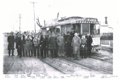 Ballarat Tramway Museum
Photograph - Black & White Photograph/s, Dave Macartney, 29/06/1968 12:00:00 AM
Has a strong association with a number of well known tram enthusiasts, some of whom were involved in tram preservation and the event to celebrate No. 27's million miles in Ballarat (not that it was correct at the time).Photocopy of a black and white photograph of Ballarat 27 at the Grey St loop with a large number of tramway enthusiasts standing in front of the tram. The tram is carrying its "Million mile banner" - 29-6-1968. Photograph on the day of the TMSV tour to celebrate the event. Written on the bottom of the sheet are the names and position on the photograph.See Key associations for hand written names and position. trams, tramways, tours, grey st loop, sebastopol, special trams, tram 27 -
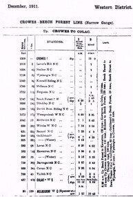 Otway Districts Historical Society
Timetable, Victorian Railways, Crowes-Beech Forest line: December 1911, December 1911
B/W. Photocopy. Crowes-Beech Forest-Colac narrow gauge line, December 1911, showing for each station the height above sea level in feet, the miles from Crowes to Colac (and Melbourne), the Station, a mixed train on Tuesdays, Thursdays and Saturdays, a mixed train on other days, and loading factors.. colac; beech forest; crowes; melbourne; railway; -
 Beechworth Honey Archive
Hand-Drawn Map Centred on Buckland Gap Road by Frank Lebbell Frost July 1916
This is one of the maps drawn by Frank L. Frost while he was beekeeping in North-East Victoria. This particular map may be reference in the "Wooden" Diary on page 8.Hand-drawn map centred on Buckland Gap road (near Murmungee). Details the quantity and quality of flowering timber in the nearby State Forest. Scale is 1/2 mile to 1 inch. Map was drawn on the 16th July, 1916. Drawn with black pen and grey lead on paper. Features are marked in red.hand drawn, hand-drawn, map, buckland gap, frost, beekeeper, beechworth honey -
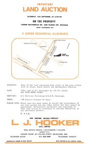 Ringwood and District Historical Society
Flyer, Residential Land Auction - Heatherdale Road, Ringwood - 1973
Single-page advertisement for auction on Saturday 15th September (1973) - 9 residential allotments on Heatherdale Road, Ringwood. Includes summary of local services and facilities, and map of area showing Verdale State School, Manhattan Hotel-Motel, and directional arrow 3/4 mile to railway station (Heatherdale) to the north.Agent - L.J. Hooker Vic. Limited, Hooker House, 327 Collins Street, Melbourne 3000, Telephone 62 0181, A.H. 232 3481, Telegrams HOOKCO. -
 Bendigo Historical Society Inc.
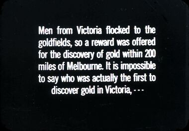
Slide - DIGGERS & MINING. THE GOLD ERA, c1850s
BHS CollectionDiggers & Mining. The Gold Era. Men from Victoria flocked to the goldfields, so a reward was offered tor the discovery of gold within 200 miles of Melbourne. It is impossible to say who was actually the first to discover gold in Victoria, - - - Markings 1 994.031GO4:5. Used as a teaching aid. Used as a teaching aid.hanimounteducation, tertiary, goldfields -
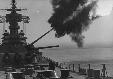 National Vietnam Veterans Museum (NVVM)
Photograph, Gibbons, Denis, USS New Jersey 2
Denis Gibbons (1937 – 2011) Trained with the Australian Army, before travelling to Vietnam in January 1966, Denis stayed with the 1st Australian Task Force in Nui Dat working as a photographer. For almost five years Gibbons toured with nine Australian infantry battalions, posting compelling war images from within many combat zones before being flown out in late November 1970 after sustaining injuries. The images held within the National Vietnam Veterans Museum make up the Gibbons Collection.A black and white photograph of the American 7th Fleet Battleship, the USS New Jersey operating on the "Gunline", Tonkin Gulf, North Vietnam. During 'Operation Sea Dragon' they open fire on land targets thirty miles inside North Vietnam. The one (1) ton shells had a special 'rocket assist'.photograph, us 7th fleet, uss new jersey, tonkin gulf, gunline, operation sea dragon, gibbons collection catalogue, photographer, vietnam war, denis gibbons, north vietnam -
 Melbourne Tram Museum
Document - Report, Tramway Board, "Northern Area - Lengths of track where traffic is abnormally frequent", 30/04/1919 12:00:00 AM
Report - single sheet, typed, titled, "Northern Area - Lengths of track where traffic is abnormally frequent", listing: 1 - Routes where 2 or more services run - giving the length in miles. 2 - route where only one service runs. Gives an analysis of the results. Two copies held.trams, tramways, cable trams, track, services -
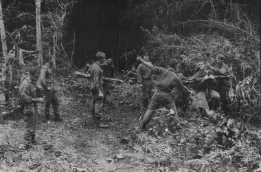 National Vietnam Veterans Museum (NVVM)
Photograph, Gibbons, Denis, Winch Extraction Preparation
Denis Gibbons (1937 – 2011) Trained with the Australian Army, before travelling to Vietnam in January 1966, Denis stayed with the 1st Australian Task Force in Nui Dat working as a photographer. For almost five years Gibbons toured with nine Australian infantry battalions, posting compelling war images from within many combat zones before being flown out in late November 1970 after sustaining injuries. The images held within the National Vietnam Veterans Museum make up the Gibbons Collection. A black and white photograph of Diggers from 1 Platoon, A Company, 8 RAR on Operation Atherton, 11 miles North West of the Australain Task Force Base, Nui Dat, prepare a wounded mate for winching out of thick jungle to be casevaced to hospital, casualities were 1 dead and 14 wounded.photograph, 1 atf, operation atherton, 1 platoon, a coy, 8 rar, dustoff, gibbons collection catalogue, australian task force, nui dat, diggers, wounded serviceman, killed in action, denis gibbons -
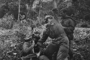 National Vietnam Veterans Museum (NVVM)
Photograph, Gibbons, Denis, Winch Extraction
Denis Gibbons (1937 – 2011) Trained with the Australian Army, before travelling to Vietnam in January 1966, Denis stayed with the 1st Australian Task Force in Nui Dat working as a photographer. For almost five years Gibbons toured with nine Australian infantry battalions, posting compelling war images from within many combat zones before being flown out in late November 1970 after sustaining injuries. The images held within the National Vietnam Veterans Museum make up the Gibbons Collection. A black and white photograph of Diggers from 1 Platoon, A Company, 8 RAR on Operation Atherton, 11 miles North West of the Australian Task Force Base, Nui Dat, signal the Dustoff crew to operate the winch for a wounded mate casevaced to hospital. Casualities were 1 dead and 14 wounded.photograph, 1 atf, operation atherton, a coy, 8 rar, dustoff, gibbons collection catalogue, digger, australian task force, nui dat, wounded serviceman, killed in action, denis gibbons -
 The Beechworth Burke Museum
Geological specimen - Gold-Sulphide Ore
This particular specimen was recovered from two hundred feet down in the Golden Mile in Kalgoorlie, Western Australia. The Golden Mile, named after the estimated sixty million ounces of gold worth around one hundred billion dollars, was the birthplace of the largest gold rush in Australia almost one hundred and thirty years ago when William Brookman and Samuel Pearce leased the Great Boulder mine. The Golden Mile is also the home of the Super Pit, Australia's most well-known mine.The majority of gold deposits will form as a native metal, however, on occasion, it can form a compound with another element, in this case, sulphur. Therefore, this specimen is a rare example of gold naturally forming into a compound mineral with sulphur. This specimen is part of a larger collection of geological and mineral specimens collected from around Australia (and some parts of the world) and donated to the Burke Museum between 1868-1880. A large percentage of these specimens were collected in Victoria as part of the Geological Survey of Victoria that begun in 1852 (in response to the Gold Rush) to study and map the geology of Victoria. Collecting geological specimens was an important part of mapping and understanding the scientific makeup of the earth. Many of these specimens were sent to research and collecting organisations across Australia, including the Burke Museum, to educate and encourage further study.A small gold-sulphide ore mineral specimen in shades of silver and grey with flecks of gold. Precious metals are often found in Sulphide Ores, as sulphides usually bind to these metals. They are also extremely symmetrical in crystaline form. Gold-Sulphide Ore occurs when gold forms a natural compound with other elements. In this form, gold can be present in one of two ways. It can be fully immersed in the sulphide, or a portion may be partially free. This specimen has minimal gold visible, with only a few flecks being partially visible.burke museum, beechworth, indigo shire, beechworth museum, geological, geological specimen, mineralogy, gold-sulphide ore -
Mission to Seafarers Victoria
Letter - Correspondence, 25/01/1952
Allan writes of the sinking of the SS Flying Enterprise. Having been damaged in a storm it was towed about 300 miles with only the captain Kurt Carlsen and the Mate from the salvage tug on board. The ship sank when hit by a second storm 40 miles off Falmouth.Quinn CollectionA pale blue self-folding letter (0893.a1) headed 37 Elsham Road, London W 14 and dated 25/01/52. Letter is typed using a very small font. It is addressed to Mrs K Hayes, 14 Fitzroy Street, St Kilda, Victoria, Australia and postmarked London W1. The return address is Allan Quinn, 37 Elsham Road, London W14. letters-from-abroad, allan quinn, alette andersen, london-uk, ss flying enterprise, captain (henrik) kurt carlsen -
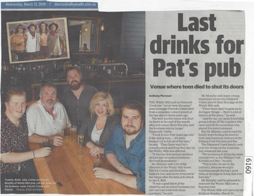 Greensborough Historical Society
Newspaper Clipping, Diamond Valley Leader, Last drinks for Pat's pub, 13/03/2019
The Windy Mile pub in Diamond Creek has 'never been the same" since teenager Patrick Cronin died from a senseless coward punch at the bar almost three years ago.The Windy Mile will serve its last drink on Sunday, March 31 2019.News article 1 page, black text.windy mile, diamond creek, patrick cronin, cronin family -
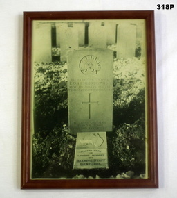 Bendigo Military Museum
Photograph - PHOTOGRAPH, FRAMED, Post 1918
Robert Oswald HENDERSON had previous service in the Militia dating from 1899 with the 67th Battalion. He enlisted in the AIF with the rank of Major as 2IC in the 38th Bn on 1.5.1916 at the age of 41 years. Embarked for England 20.6.1916, embark for France 22.11.1916, promoted to Lt Col to command the 39th Bn 15.2.1917, hospital 17.9.1917 with Defective vision, appears to a have rejoined his unit same day, WIA 29.3.1918 GSW to left thumb, rejoin unit 13.6.1918, KIA 29.9.1918 near Bony on the Hindenburg Line. Buried by the Rev W.A.Moore on 1.10.1918. He was awarded the DSO 18.1.1918 and Mentioned in Despatches 25.5.1918. The Beehive Store was a major Department Store in Pall Mall Bendigo.Photo of the Australian War Grave in France of Lt Col. R O HENDERSON DSO 39Bn. KIA. Headstone reads "Placed here in Loving Memory by/ BEEHIVE STAFF Bendigo". Message written on back of photo states he was buried at St Emilie, a town about 6 miles N E of Perrone.On back of Frame "Photo Mrs J H Henderson" photos, graves, framed, ww1 -
4th/19th Prince of Wales's Light Horse Regiment Unit History Room
Station Radio C13
Used by all Royal Australian Armoured Corps vehicles. Mid 1950's to mid 1970'sEquipment used by the RegimentA HF voice and CW sender-receiver for use in vehicles or as ground station. Consists three main units - the sender/receiver, the power supply unit, and aerial tuning unit. Power supply was either 12 or 24 volt. Frequency range 1.5 - 12.0 Mc/s. Operating range up to 25 miles.Radio - No 0549, Supply unit vibratory - No 1545, Aerial Tuning Unit No 1397radio, c13 -
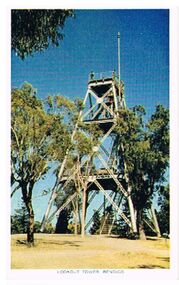 Bendigo Historical Society Inc.
Postcard - LOOKOUT TOWER ROSALIND PARK BENDIGO
Postcard: poppet head lookout tower, Rosalind Park, Bendigo. Image shows poppet head, eucalypt trees surrounding it. On bottom ' Lookout Tower, Bendigo' On back 'situated 92 miles north of Melbourne, Bendigo is the gateway to Northern Victoria. It is an attractive City with many modern facilities, fine Gardens and Cultural centres.Nucolorvue Productions, No. 12, Copyright.bendigo, buildings, lookout tower, rosalind park, bendigo, lookout tower, poppethead, rosalind park -
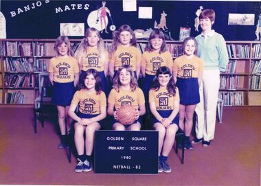 Bendigo Historical Society Inc.
Photograph - GOLDEN SQUARE PRIMARY SCHOOL COLLECTION: NETBALL TEAM 1980
Colour photograph: Grade 5 team : back row : Rachel Haythorne, Brenda Miles, Leanne Atherton, Anita McLean, Leanne Strauss, Mrs. B. O'Shea coach) Front row: Elizabeth Sheen, Natasha Lister, Linda Thompson. Sign in front: Golden Square Primary School 1980 netball C3.bendigo, education, golden square primary school -
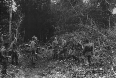 National Vietnam Veterans Museum (NVVM)
Photograph, Gibbons, Denis, Winched Out
Denis Gibbons (1937 – 2011) Trained with the Australian Army, before travelling to Vietnam in January 1966, Denis stayed with the 1st Australian Task Force in Nui Dat working as a photographer. For almost five years Gibbons toured with nine Australian infantry battalions, posting compelling war images from within many combat zones before being flown out in late November 1970 after sustaining injuries. The images held within the National Vietnam Veterans Museum make up the Gibbons Collection. A black and white photograph of diggers from 1 Platoon, A Company, 8 RAR on Operation Atherton 11 miles North West of the Australian Task Force Base at Nui Dat, watch one of their wounded mates winched out of the thick jungle to be casavaced to hospital. Casualities were 1 dead and 14 wounded.photograph, 1 platoon, a coy, 8 rar, operation atherton, gibbons collection catalogue, wounded serviceman, australian task force, nui dat, diggers, killed in action, denis gibbons -
 Bendigo Historical Society Inc.
Map - FRED COWIE COLLECTION: AERIAL MAPS OF HEATHCOTE/EPPALOCK, 28-9-60
Map, Heathcote C4, Aerial Survey of Victoria,Photo-map prepared by Department of Crown Lands and Survey from photographs taken in 1960. Copied photographically at the Central Plan Office.Date 28-9-60,C.P.O.Neg.No.21590.Scale 4 inches to 1 mile. Fred Cowie,46 McIvor Rd,Bgo..Central Plan Office.map, heathcote, fred cowie -
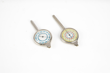 Department of Energy, Environment and Climate Action
map measuring wheels
The map wheel is a simple, fast and accurate way to measure distances on maps, whether in straight lines or along curves. Hold the device from the tip and trace with the small wheel at the bottom along the line to be measured Measures distances in miles, kilometres or nautical miles depending on the scale on the side.Two metal map measuring wheel sMap scales on each side of wheelforests commission victoria (fcv), surveying, mapping -
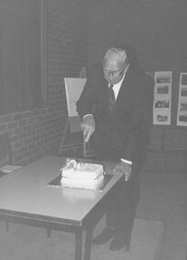 Ringwood and District Historical Society
Photograph, 1979 Ringwood Historical Research Group 20th Annual General Meeting
Catalogue card reads, '1979 - Ringwood Historical Research Group, 20th Annual General Meeting, Sept. 1979. [Picture shows] Paddy Miles cutting cake'. -
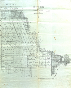 Federation University Historical Collection
Map, Doroq County of Grenville L4935, 1911, 28 June 1911
This plan is associated with former Ballarat School of Mines Student Richard Squire (1875-1876). Gift of the Squire FamilyParish Plan of Doroq in black ink printed on cream paper. It includes the township of Inverleigh and Barwon Rover. Some of the names on the plan are William McRobie, William MacRobie, Thomas Russell, W.C. Smith, John Bell, J. Moffatt, Thomas Moffatt, John Anderson, George Synnot, Charles Lloyd, William MacRobie, J. Flack, Alexander Campell, T. Maher, William Berthon. Thomas Jewell, James Carstairs, D. MCInnerney, F.H. Holland, Robert Morrison17 7/9 18 9 miles handwritten in pencil Photo lithographed at the Department of Lands and Survey Melbourne by T. E. McGauran 28.6.11 Price 1/-carrunge-murnong, murdeduke, carrah, shelford, inverleigh, barwon river, hesse, wingeel, george russell, george russell's pre-emptive section, john moffatt, w. c. smith, macrobie, john bell, thomas russell, t.f. mcgauran