Showing 1093 items matching "mini-computer"
-
 Bacchus Marsh & District Historical Society
Map, Plan showing relative positions of the Gisborne road formation and Mr. Cosgrove's land in Darley. 1907
No background information about the roadworks referred to in this plan has been found. The portion of land referred to as 'Cosgroves' in this plan is located close to the present day Darley Park Recreation Park in Darley, near Bacchus Marsh. The land indicated appears to be close to the corner of Grey Street and Gisborne Road. James Cosgrove who died in 1923 aged 65 owned a farm of 52 acres in this area of Darley.Single page map showing a proposed deviation of the Gisborne road in Darley and its position relative to land owned by Mr. Cosgrove. The land owned by Cosgrove is shaded in pink. No scale indicated. Part of a set of maps which are pasted into a bound volume containing 76 maps or plans in total. High resolution digital image stored on BMDHS computer network. Signature (illegible), Eng, Bac Marsh Shire, 30/9/07bacchus marsh roads and streets, darley victoria maps -
 Bacchus Marsh & District Historical Society
Map, Village allotments, Parish of Myrniong, County of Bourke
Myrniong is a village 9 kilometers west of Bacchus Marsh. Prior to 1863 the area was known as Blow's Flat. This map which was produced in 1903 and according to the catalogue record of this map held at the State Library of Victoria was based on an earlier map created in 1861. The early layout of streets for the village of Myrniong can be seen on this map. The streets shown are, Main Street, Hardy Street, Blow Street, Myrniong Street, Shuter Street, and Blackwood Street. An area marked as a reserve for a school can be seen between Hardy Street and Main Street.A single page paper map. A cadastral parish map of Myrniong in Victoria, showing numbered land allotments. Photo-lithographed at the Department of Lands & Survey, Melbourne, in 1903. Based on an original map created in 1861. The map is pasted into a bound volume containing 76 maps or plans in total. High resolution digital image stored on BMDHS computer network. Surveyed by John Hardy, Surveyor ; photo-lithographed at the Department of Lands & Survey, Melbourne by T.F. McGauran, 24.12.03myrniong parish plan, myrniong parish maps -
 Bacchus Marsh & District Historical Society
Map, Lerderderg Gorge Road Goodmans Creek to Gisborne Road
The date of this map and its purpose has not been established. It was possibly produced to indicate landholders who were impacted by works along the Lerderderg Gorge Road. A single page paper map showing various blocks of land along the route of the Lerderderg Gorge Road near Bacchus Marsh from Goodmans Creek to the point where the road joins with Gisborne Road. The map is pasted into a bound volume containing 76 maps or plans in total. High resolution digital image stored on BMDHS computer network. bacchus marsh victoria maps, lerderderg gorge road bacchus marsh maps -
 Whitehorse Historical Society Inc.
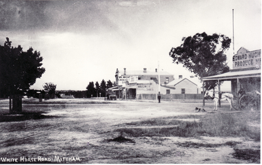
Photograph, North Corner of Whitehorse & Mitcham Road, Mitcham, c1920's
Black and white photo of the northern cnr Whitehorse and Mitcham Roads, Mitcham, showing Hughs Produce Store, with his white horse and delivery waggon outside. This was later the site of Mirama Court, later to be refurbished as shops and offices.|The vacant land on the far corner became a grocers shop and later the Westpac Bank. It is currently (2005) a computer sales shop.hughes produce store, mitcham road, mitcham, whitehorse road mitcham, mirama court mitcham, westpac bank -
 Victorian Aboriginal Corporation for Languages
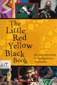
Book, Bruce Pascoe, The little red yellow black book : an introduction to Indigenous Australia, 2008
The Little Red Yellow Black Book is an accessible and highly illustrated pocket-sized guide. It's an invaluable introduction to Australia's rich Aboriginal and Torres Strait Islander histories and culture. It takes a non-chronological approach and is written from an Indigenous viewpoint. The themes that emerge are the importance of identity, and adaptation and continuity. If you want to read stories the media don't tell you, mini-essays on famous as well as everyday individuals and organisations will provide insights into a range of Australian Indigenous experiences.maps, b&w photographs, colour photographsindigenous history, culture, art, sport, health, education, employment, reconciliation, resistance, governance -
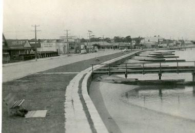 Lakes Entrance Historical Society
Postcard - Lakes Entrance, Bulmer H D, 1940c
From a wallet of minitiature postcards published by Bulmer for sale to tourists. Also enlarged black and white copy 18.5 x 25 cm,Black and white mini postcard of Esplanade, showing timber groynes for sand control at edge of lake at walking path of concrete slabs. Across the highway from left to right is Kia-Ora House, Heyfield House, Coate Bros Garage, Robin Hood Inn, Vizes Cafe, Vic Carstairs, Miss Brown's (subagent for Statebank), Methodist Church, Bellevue Guest House, Police Station, Maranui Guest House, Glenara Guest House. Lakes Entrance Victoriatownship, waterfront, accommodation -
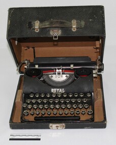 Wodonga & District Historical Society Inc
Functional object - Royal Typewriter associated with the J. Mann & Sons General Store
The typewriter was owned by John Stephens, a grocer at the J. Mann & Sons General Store in Wodonga from 1971. John purchased the typewriter in the 1940s. He died in 1990. The maker of the machine, Royal Typewriter Company Inc. was founded in New York City in 1904 by Edward B. Hess and Lewis C. Myers. The company was purchased by Italian typewriter and computer manufacturer Olivetti in 1986. John Stephens typewriter forms part of a collection of objects from the J. Mann & Sons General Store held by the Wodonga Historical Society, and reflects the social history of the city. Black metal typewriter in black leather caseMaker logo "ROYAL" embossed on the face of the typewriter above the keys in silver, and on the back of the machine under paper tray. Serial number engraved on the back left inner corner of the typewriter reads J37338typewriter, social history, wodonga, commerce, mann, j. mann & sons -
 Bialik College
Work on paper (Item) - Bnei Mitzvah 2023 bunting
2023 Year 7 Students created family emblems and/or crests in relation to their Bnei Mitzvah. Some pictures are hand drawn and copied in colour, others are computer generated. Some are original images which others are a composite of online open access material. Four portions are missing, one removed due to mildew Please contact [email protected] to request access to this record. bnei mitzvah, hebrew, jewish school, art, display, exhibition -
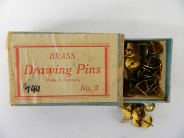 Kiewa Valley Historical Society
Pin Drawing, Brass tacks, mid to late 1900's
This particular box of brass drawing pins would have been used before the introduction of cheaper polished chrome drawing pins manufactured in Asia. The box construction and label would suggest that supply of this boxes contents could have been in the early 1950's. Drawing pins or push pins were first invented in 1900 by Mr Edwin Moore. The need for a secure fastener to accommodate temporary signs and notes for domestic and commercial environments sprang up from the need to cope with an increasing faster method of presenting information on removable surfaces such as temporary notice boards. In the 1950's and later the increase in the pace of "living" brought about many time saving written communication notices. This temporary method of providing fast temporary notices is being surpassed by the computer age and mobile telephone "applications". The information spectrum of the computer age has made many "hands on" (drawing pin) applications go to the "dodo" level. This box of drawing pins is very significant to the Kiewa Valley and its region because it demonstrates that the pace in rural regions especially those that were once semi remote regions has moved at the same pace as the bigger towns and cities. Differences are still noticeable, such as the requirement of drawing pins for temporary signs and mail box commercially important "sales" notifications. The pressures that produce the "rat" syndrome, that is pressure by increased population levels infringing upon the individual's day-to-day existence is still not present in rural areas such as the Kiewa Valley. Drawing pins are still a requirement for leased accommodation (which are usually short term accommodation) for the personalisation of "home" wall decorations and shopper's "notice and information boards"This small box, similar to a "match box" (thumb activated slide, top open, cardboard container), holds brass drawing pins. These brass pins are also known as brass tacks, thumbtacks or push pins. The top of the brass tack has a "domed head" with the manufacturer's logo stamped on it. The number "2" on the bottom right of the label is the "weight" of the drawing pin. On the front and within a red border and red letters "BRASS" and below this in script form "Drawing Pins" and below this in smaller letters "Made In Germany" Below this and on the bottom left side "100" and also on the bottom but to the right "No. 2"notice and information boards, quick temporary fasteners., pins, tacts, brass tacts, domestic, decorations -
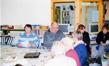 Stawell Historical Society Inc
Photograph, Various BIARRI photographs
7152: 8 PEOPLE, 7 PEOPLE SITTING AROUND A TABLE, 1 SITTING AT ANOTHER TABLE. 7152 -1: 4 PEOPLE SITTING AROUND A TABLE, OLD COMPUTER TO THE RIGHT. 7152-2 A GROUP OF PEOPLE SITTING AROUND A TABLE COVERED IN PAGES AND BOOKS. 7152-: 5 WOMEN STANDING HOLDING CERTIFICATES, ONE MALE SEATED IN FRONT HOLDING CERTIFICATE TO LEFT.biarri -
 Bacchus Marsh & District Historical Society
Map, Coimadai Parish Map, County of Bourke. Circa 1890s-1900s
The cadastral Parish of Coimadai, a subdivision of the County of Bourke, lies directly north of the township of Bacchus Marsh. The date of this map is uncertain. T.F. McGauran the person who made a photo-lithographic copy of the map was in charge of photo-lithography at the Victorian Department of Lands and Survey in the late 19th century until about 1910.A single page paper map showing the map for the Parish of Coimadai in the County of Bourke. A cadastral map showing parish boundaries and land ownership. A rectangle shaped area is missing from the centre of the map due to a tear or deliberate excision. The map is pasted into a bound volume containing 76 maps or plans in total. High resolution digital image stored on BMDHS computer network. Photo-lithographed at the Department of Lands and Survey, Melbourne by T.F. McGauran 26.8.[??] NOTE. Photo litho from L.P showing temporary surveys and occupation of land prepared for departmental use onlybacchus marsh region parish plans, coimadai parish maps, coimadai parish plan -
 Melbourne Tram Museum
Pamphlet, Yarra Trams, "Free TramTracker", Apr. 2013
Pamphlet, DL, printed on gloss card, titled "TramTracker" - Yarra Trams real time tram arrival information. Has the TramTRACKER logo (dog) foldout at the top of the card when folded into half. Provides instructions how to use it on the iPhone, Android and other smartphones. and computer systems. Advises passengers where to find the TramTRACKER ID for each stop. .1 - Hangingtrams, tramways, yarra trams, tramtracker, tram stops, operations, computer systems -
 Melbourne Tram Museum
Photograph - Digital Image, Kevin O'Reilly, Kew Barkers Rd, c1930
Image from CD (Compact Diskette for use in computers) - see Reg Item 135. Image titled "Kew Barkers Rd" on CD, looking west from over Kew Junction towards Victoria Bridge over the Yarra River. Has a W class tram, eastbound in Victoria St, about to cross the bridge. c1930 (Cable conversion late 1929)trams, tramways, kew, barkers rd, victoria st -
 Bacchus Marsh & District Historical Society
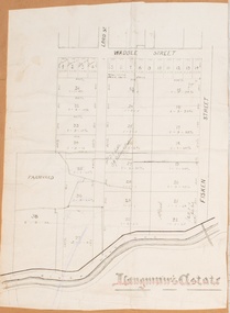
Map, Langmann's Estate Bacchus Marsh
The date of this map has not been determined. It bears the signature of D.A. Little upon of a portion of the map. Little was Bacchus Marsh Shire Secretary and Engineer between 1886 and 1914 which dates the map to some time between 1886 and 1914.A single page paper map showing a portions of land in part of Bacchus Marsh.The area shown is described as Langmann's Estate. The area is bounded by the Werribee River, Fisken Street, Waddle Street(sic.) (Waddell) and Lord Street. The map is pasted into a bound volume containing 76 maps or plans in total. High resolution digital image stored on BMDHS computer network. bacchus marsh victoria maps -
 Bendigo Historical Society Inc.
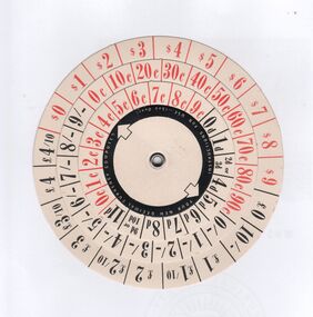
Ephemera - Decimal currency computer, Win Jennings Collection, 1966
Conversion of Australian currency from pounds/shilling/pence to dollars/cents. on 14 February 1966.Circular paper computer used by hand to convert pounds/shilling/pence to dollars/cents, or the reverse calculation. Printed in 1965/64 for the conversion of Australian currency which was affected on 14 February 1966. Printed in red and black on four circular plains. Printed by Earles Printing Pty Ltd for Ultra Publicity Pty Ltd, 104 Wellington parade, East Melbournebendigo, decimal converter -
 Bendigo Military Museum
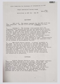
Administrative record - Joint Committee for the exchange of Information on ADP within the RASvy Corps, Activities Jun- Dec 1985, Army Survey Regiment, December 1985
Automated Computer Processing (ADP) was instrumental to the successful operation of the Royal Australian Survey Corps Mapping capability and production. This paper describes elements of the ADP with a comprehensive description of each. They Include, PDP 11/70 Memory, Map Stock Control System, Digital Terrain Elevation Data, Digital Terrain Model Package, ASMAPS, ASTIS, Reflectance Hill Shading, Aerial Triangulation and Terrain Analysis.Two page paper report about Automated Data Processing, unstapledHand annotated "Folio 74" in top right hand cornerroyal australian survey corps, rasvy, fortuna, army survey regiment, army svy regt, asr -
Bialik College
Photograph (Item) - School photographs, c1980s, various activities
School photographs taken at various school events throughout the 1980s. Some specific photographs are labelled from 1984, showing students working on a computer, in the junior school, playing sport, musical instruments, art, woodworking room, library Includes Bnei Mitzvah photographs. Images from 1988, look to be at a school photography exhibition. No names included. For inquiries or access contact [email protected] school, bialik college, photographs., school -
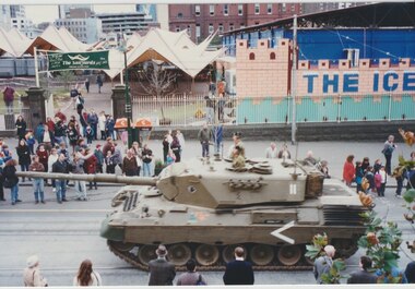 Melbourne Legacy
Photograph - Photo, Tanks on Swanston Street
Photos of two tanks driving along Swanston Street taken from the windows of Legacy House. The occasion is not known. The tanks appear to be Leopard 1. One has elaborate equipment on the front. The date is approximately the late 1990s as the Queen Victoria Hospital has been demolished and the QV building has not been started. On the site opposite Legacy House is an open air market called The Sailyards, and what appears to be an ice rink or mini golf, called The Icehouse. Also on the site was the YMCA run skate park called Sail Yards, it was closed in 2001.A record that military equipment was of interest to the Legatees.Colour photos x 4 of two tanks driving North up Swanston Streettanks, streetscape -
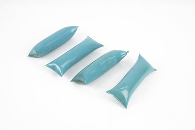 Department of Energy, Environment and Climate Action
Blivet incendiaries
Blivets were developed in the 1960s and 70s. The small package contained jellied petrol which had a small electric match or detonator wrapped around it. They were mainly used as high intensity slash burns and could be wired-up days or weeks before they were required. The blivets were arranged in concentric circuits to develop a large convection column. But the circuits were prone to damage by wildlife if left out too long. DAIDs were also taped to blivets as mini “Molotov Cocktails” and thrown into patches of dense or hard-to-access slash. Small plastic container filled with jellied petrol.forests commission victoria (fcv), planned burning -
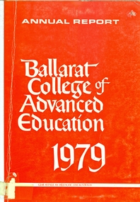 Federation University Historical Collection
Book, Ballarat College of Advanced Education Annual Report, 1979, 1979
In 1980 the President was M.B. John. In 1980 the administration staff moved out of the lower level of the library and the space was converted for teaching use. Extensive alterations were made to the lower level of the mechanical/Civil Engineering wing for the housing of Applied Geology and Environmental Science. Car parking facilities were extended at Mt Helen.Orange soft covered book of 35 pages. Contents include: Courses, student numbers, Victorian School of Forestry, financial statement, Education Building (T Building) completed, Gillies Street Campus, Art building under construction, Great Hall (1870s Founders Hall) completion date expected to be mid 1980, Centenary Appeal, E.J. Barker Library, Computer Centre, bookshop . ballarat college of advanced education, bcae, mt helen, mount helen, library computer -
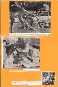 Bendigo Historical Society Inc.
Newspaper - GOLDEN SQUARE P.S. LAUREL ST. 1189 COLLECTION: NEWSPAPER CUTTINGS
Yellow, laminated card with three newspaper cuttings. The first is a photo of Tracey Saunders in the 11 years high jump at the sports. The second is a photo are three girls learning to use a computer. They are Megan Baxter, Johanna White and Candice Reid. The third is a photo of Jaclyn Curnow and John Rainbow who received rewards recognising attitudes to school and fellow students, community - - (cut off) and sporting achievement.education, primary, golden square laurel st p.s., golden square primary school 1189 collection - newspaper cuttings, tracey saunders, megan baxter, johanna white, candice reid, jaclyn curnow, john rainbow -
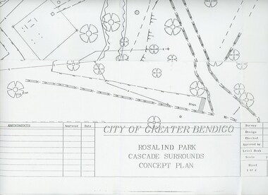 Bendigo Historical Society Inc.
Plan - MERLE HALL COLLECTION: ROSALIND PARK CREATIVE VILLAGE BENDIGO PROJECT CONCEPT PLAN, 1993
MERLE HALL COLLECTION: ROSALIND PARK CREATIVE VILLAGE BENDIGO PROJECT Concept Plan City of Greater Bendigo Rosalind Park Cascade Surrounds Concept Plan number GB095 Sheet 1 of 2 Level Book 365, Backup No Tape 01, Computer File No. ROS QEO. Large Sheet which shows the location of utilities, vegetation, drains, embankments etc. June 1993 -
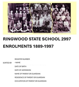 Ringwood and District Historical Society
Book, Ringwood State School 2997 - Enrolments 1889-1997
Blue A4 size 2-ring binder containing 129-page computer printout of transcribed Ringwood State School no.2997 rolls sorted alphabetically by pupil name, with details of register number, date of birth, date of admission, name of parent or guardian, and residential address and occupation of parent or guardian. List transcribed from original enrolment registers by Ringwood and District Historical Society, 2022. -
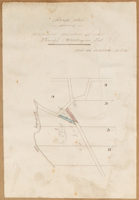
![Map, [Plan for road to give J. Allan access to permanent water at Coimadai] circa 1870s](/media/collectors/5e461d8021ea67224c82f2a1/items/67735190d671e67dd573a84c/item-media/6773533dd671e67dd573cd90/item-fit-380x285.jpg) Bacchus Marsh & District Historical Society
Bacchus Marsh & District Historical SocietyMap, [Plan for road to give J. Allan access to permanent water at Coimadai] circa 1870s
The date of this map or plan is uncertain but it appears to be from the early to mid 1870s. One of the landholders identified on the plan, James Allan of Coimadai died suddenly on the 9th July, 1874 (see Bacchus Marsh Express, 11 July, 1874, page. 3). There are mentions of an Allans Road at Coimadai in the Bacchus Marsh Express between 1887 and 1942.Single page map showing an excision of land belonging to Charles Ross which was selected to construct a road to give another landholder, J. Allan access to permanent water. Scale 1 chain to 1 inch. Part of a set of maps which are pasted into a bound volume containing 76 maps or plans in total. High resolution digital image stored on BMDHS computer network. Plan showing Excisions from Ross's selection and 1 chain road thro' the said selection in Coimadai to give J. Allan access to permanent water. Alistair ?? Shire Eng? 6?/5/7?coimadai victoria maps, coimadai roads and streets -
 Bacchus Marsh & District Historical Society
Map, Rough plan showing proposed deviation of road through McKenzie's Flat
The date of this map or plan is uncertain. McKenzie's Flat is a bushland picnic area on the Lerderderg River in the Lerderderg State Park close to Bacchus Marsh. Single page map showing a proposed deviation of the road near the McKenzie's Flat area close to Bacchus Marsh. The proposed deviation is shaded in pink, The existing road section to be replaced is shaded in blue. No scale is indicated. Part of a set of maps which are pasted into a bound volume containing 76 maps or plans in total. High resolution digital image stored on BMDHS computer network. mckenzies flat bacchus marsh, bacchus marsh roads and streets -
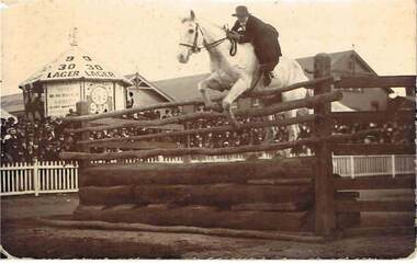 Bendigo Historical Society Inc.
Postcard - COHN BROTHERS COLLECTION: WOMEN SHOW JUMPING, Date unknown
Photograph of a woman in an equestrian event, she is riding a light coloured horse and jumping a high hurdle, there is a white picket fence surrounding the arena and a large number of spectators. On the left of the picture is a mini clock tower with a white roof and '9.30 Lager' written on it in large black letters, on the right there is a clock face with 'non - intoxicating' written above this. There is also a sign reading ' Farmers Notice , we are buyers of Barley in any Quantity. On the back hand written is ' Australian Champion High Jump Record, Bendigo Show,postcard, bendigo show, cohn brothers , 9.30 lager -
 Uniting Church Archives - Synod of Victoria
Photograph, 1979
David Norman Loader had been principal of an independent school in Orange NSW, and was appointed Principal of Methodist Ladies' College in 1979. Following his term at MLC, he was appointed Principal of Wesley College Melbourne 1997-2002. He was the driving force behind the establishment of the Clunes campus of Wesley and the introduction of notebook computers to the secondary years throughout Wesley. He retired to take on private consultancy work from 2002.B & W Gloss Head and Shoulders photograph of Mr David Loader, taken at the commencement of his Principalship of Methodist Ladies' College for "Church and Nation" in 1979.david norman loader; principal methodist ladies' college; principal wesley college melbourne -
Vision Australia
Audio (item) - Sound recording, Royal Victorian Institute for the Blind, Around the Institute: January 15, 2002
Around the Institute was a weekly program designed to keep clients and staff informed of events, activities and thoughts relating to low vision and blindness. It consisted of interviews undertaken by Jo Matthews-Lamb, Susan Thompson, Janet Cronin and Corey Nassau, with sound engineer Ed Gamble, designed to inform, educate and explore on a variety of topics. January 15: Computer training courses – Dale Moore, Hume region update – Julie Johnson.royal victorian institute for the blind, radio shows -
Vision Australia
Audio (item) - Sound recording, Royal Victorian Institute for the Blind, Around the Institute: September 4, 2001
Around the Institute was a weekly program designed to keep clients and staff informed of events, activities and thoughts relating to low vision and blindness. It consisted of interviews undertaken by Jo Matthews, with sound engineer Ed Gamble, designed to inform, educate and explore on a variety of topics. September 4: Recreation update – Chris Headland, Book review – Marcus Stacey, M40 program – Janet Cronin, Website and computer tips – Glen Morrow. royal victorian institute for the blind, radio shows -
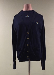 Kew Historical Society Inc
Clothing - Blue Wool Twin Set with Embroidered Logo, Vivienne Westwood, 1980s
This Item is part of an outfit owned, worn and donated by Annie McIntyre. Worn in 1986 it was part of a major collection designed by Vivienne Westwood. The V&A includes information about the minicrini collection that Westwood launched in Spring/Summer 1985 which "...marked what Westwood described as a "cardinal change" – a shift towards tailoring and "things that fitted" – and a more deliberate focus on reworking ideas taken from historical dress. The stand-out garment of Mini-Crini was Westwood's short, bell-shaped skirt – another cheekily sexual garment that combined the outline of a child's party frock with an abbreviated version of the Victorian crinoline."The McIntyre Collection of clothing and clothing accessories forms one of the largest single donations to our Fashion & Design collection. It includes clothing and clothing accessories worn by four women in the Cohen and McIntyre families across three generations. The items worn by Melbourne architect, and Kew resident, Dione McIntyre date from the 1960s and 1970s, and include evening wear, day wear, hats and shoes. As Dione McIntyre often accompanied her husband, fellow architect Peter McIntyre, to formal events, there are a number of pieces of evening wear among the items. The McIntyre Collection also includes items worn by women of an earlier generation: by Lilian Cohen, Dione McIntyre's mother, and by her mother-in-law, the wife of the architect Robert McIntyre. At the other end of the chronological spectrum are a number of outfits belonging to, worn and donated by Annie McIntyre. These include outfits created by notable late 20th century Australian and/or international fashion designers. The McIntyre Collection is significant historically and artistically as it includes examples of design that demonstrate changing tastes in fashion over an 80-year period. The collection is also significant in that it includes the work of a large number of Melbourne designers from the 1960s to the 1990s. Navy blue woollen twin set designed by Vivienne Westwood. The twin set was worn with a wool minicrini by the same designer.A note written by Dione McIntyre accompanying the item describes its relevance and use: "Vivienne Westwood 3-piece ensemble purchased in London in the 1980s - consisting of navy 'twin set' and balloon skirt - worn with long white socks and dark flat shoes. Donated by Annie McIntyre."mcintyre collection, womens clothing, international fashion - london - 1980s, annie mcintyre, vivienne westwood, minicrini