Showing 25576 items matching "plenty-township-estate"
-
 Eltham District Historical Society Inc
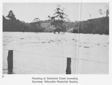
Work on paper (Sub-Item) - Photograph, Flooding at Diamond Creek Township
Black and white photograph of the Diamond Creek in flood at Diamond Creek township in 1934. In 1934 extensive flooding of the Yarra River and Diamond Creek set new records for flood plain level (Eltham Chronology EDHS) Nillumbik Historical Society collectionflood, diamond creek, flooding, nillumbik historical society -
 Eltham District Historical Society Inc
Document - Property Binder, Plenty River Bridge, Main Road, Lower Plenty
Extracts Heidelberg Council Minutes re Plenty Bridge, 3 September1862, 10 May 1865, 22 May 1865, 5 June 1865 , 10 October1866, 14 November1866, 13 February 1867.main road, property, houses, shops, businesses, plenty bridge -
 City of Kingston
Pamphlet - Colour, H. R. Hill & Co, Walker's Estate, Cheltenham for sale by public auction, c. 1923
Sales plan for land in the suburb of Cheltenham, encompassing both sides of Walker Grove, a section of Centre Dandenong Rd and Axelton St. The developing urban area of Cheltenham within the City of Kingston. This land sale pamphlet illustrates the subdivision of land within the municipality and the changing demographic of the district as new houses are constructed.Black and white pamphlet advertising for private sale the Station Entrance Estate, Highett. Incorporates a map of the estate bordered by Wickham Road, Railway Parade, Highett Road and Point Nepean Road.Handwritten in black pen on subdivision map: 'x' written on subdivisions 2, 3, 8-11, 15-17, 19. Potentially indicating that these properties did not sell at auction. Handwritten in black pen on subdivision map: assumed sale price on subdivisions 1, 4-7, 12-14, 18, 20-31. land sales, cheltenham, estate -
 Ringwood and District Historical Society
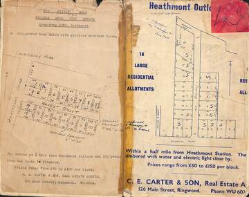
Card - Subdivision Maps, Millers Beau View Estate and Heathmont Outlook Estate Subdivisions, Heathmont, Victoria - (Undated - circa 1950s)
Two maps of seperate parts of Heathmont - Light cardboard backing with handwritten real estate sales notations - 18 home sites on Harriet Street and Armstrong Road and 18 residential allotments on The Outlook and Dickasons Road. -
 Surrey Hills Historical Society Collection
Book, Medlow and the Bismark Estate by Prof. Miles Lewis, 1990
The Medlow Estate is a remarkable testimony to the unfulfilled expectations of the land boom of the 1880s to early 1890s. The areas of the former lot 14 or the lines of Varzin Avenue and Friedrichsruh Street where they pass through the present grounds will be conserved as may seem appropriate to exhibit the development of the garden in the Cairncross and Bull periods.The Medlow Estate is a remarkable testimony to the unfulfilled expectations of the land boom of the 1880s to early 1890s. The areas of the former lot 14 or the lines of Varzin Avenue and Friedrichsruh Street where they pass through the present grounds will be conserved as may seem appropriate to exhibit the development of the garden in the Cairncross and Bull periods.bismark estate, rosalie estate, conservation of natural resources, (mr) rex swanson, landform australia, cairncross family, medlow, varzin avenue, warrigal road, surrey hills, friedrichsruh street, (mr) (dr) r j bull, (miss) mary jane cairncross, g n taylor -
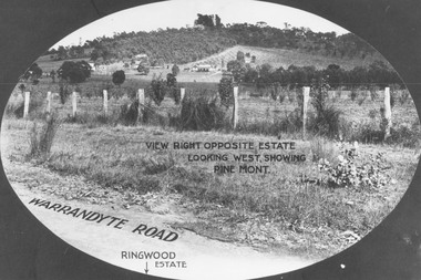 Ringwood and District Historical Society
Photograph, View from Warrandyte Road opposite Ringwood Estate looking west, showing Pine Mont. (no date)
Printed onto photograph, "View right opposite estate looking west, showing Pine Mont". Roadway identified as "Warrandyte Road" and "Ringwood Estate" printed at bottom of picture. -
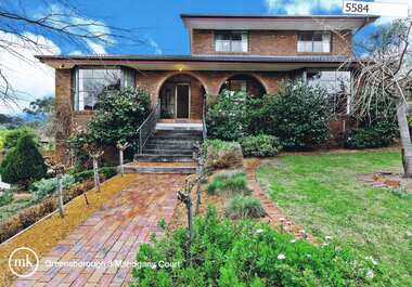
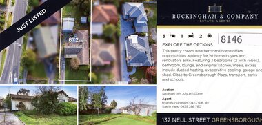 Greensborough Historical Society
Flyer - Advertising Leaflet, Buckingham and Company Estate Agents, 132 Nell Street Greensborough, 2023
132 Nell Street Greensborough. 3 bedroom home, sold July 2023 for $865,000. Real Estate advertising leaflet, 1 sheet, printed in colour both sidesnell street greensborough -
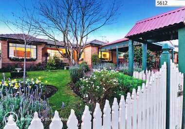 Greensborough Historical Society
Advertising Leaflet, 53 Airlie Road Montmorency, 25/11/2012
53 Airlie Road Montmorency. 4 bedroom home, sold December 2012 for $645,000. Previous sales: February 1999 for $235,000 and March 1997 for $124,000.Real estate advertising leaflet, 1 sheet, printed in colour both sidesairlie road montmorency -
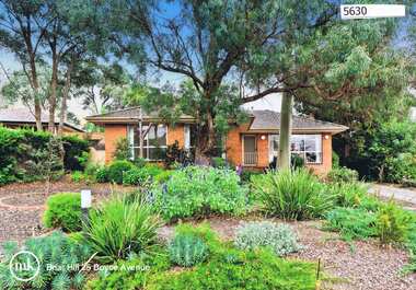 Greensborough Historical Society
Advertising Leaflet, 25 Boyce Avenue Briar Hill, 16/04/2011
25 Boyce Avenue Briar Hill. 3 bedroom home, auctioned 16 April 2011, sold for $572,000Real estate advertising leaflet, 1 sheet, printed in colour both sidesboyce avenue briar hill -
 Greensborough Historical Society
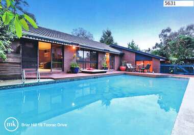
Advertising leaflet, 19 Toorac Drive Briar Hill, 16/03/2012
19 Toorac Drive Briar Hill. 3 bedroom home, private sale, sold 16/03/2012 for $520,000Real estate advertising leaflet, 1 sheet, printed in colour both sidestoorac drive briar hill -
 Greensborough Historical Society
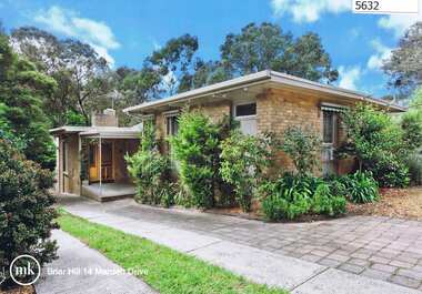
Advertising Leaflet, 14 Marden Drive Briar Hill, 31/10/2012
14 Marden Drive Briar Hill. 3 bedroom home, private sale, sold 31 October 2012 for $537,800Real estate advertising leaflet, 1 sheet, printed in colour both sidesmarden drive briar hill -
 Greensborough Historical Society
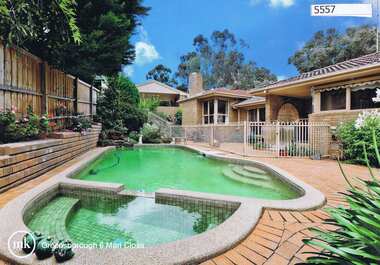
Advertising Leaflet, Morrison Kleeman Real Estate, 6 Mari Close Greensborough, 24/01/2012
4 bedroom house, auctioned February 2012 for $555,000 (sold again in October 2016 for $838,000)Real estate advertising leaflet, 1 sheet, printed in colour both sidesmari close greensborough -
 Greensborough Historical Society
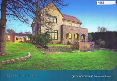
Advertising Leaflet, Jellis Craig Real Estate, 43 Grimshaw Street Greensborough, 11/08/2012
The 6 bedroom house on 1836 sq m.was sold 11 August 2012 for $1.3 million. Known as "Ashmead" this property was previously the home of the Cordner family.Real Estate advertising leaflet, 4 p., printed in colour on both sidesgrimshaw street greensborough, ashmead, cordner family -
 Greensborough Historical Society
Advertising Leaflet, 7 Meron Court Greensborough, 23/02/2013
7 Meron Court Greensborough: Auction 23 February 2013, sold $442,000Real Estate advertising leaflet, 1 sheet, printed in colour both sidesmeron court greensborough -
 Greensborough Historical Society
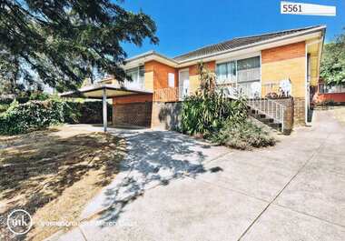
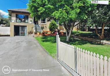
Advertising Leaflet, 37 Alexander Street Greensborough, 14/11/2012
37 Alexander Street Greensborough: Three bedroom home, private sale, sold 14 November 2012 for $505,000Real estate advertising leaflet, 1 sheet, printed in colour both sidesalexandra street greensborough -
 Greensborough Historical Society
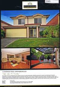
Advertising Leaflet, 12 Warwick Road Greensborough, 08/07/2016
12 Warwick Road Greensborough: 3 bedroom home, private sale, sold November 2012 for $590,000, and 08/07/2016 for $691,000Real estate advertising leaflet, 1 sheet, printed in colour both sideswarwick road greensborough -
 Greensborough Historical Society
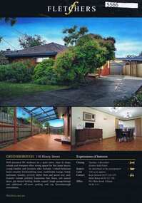
Advertising leaflet, 110 Henry Street Greensborough, 04/11/2012
110 Henry Street Greensborough: 3 bedroom home, private sale, sold 4 November 2012 for $405,000Real Estate advertising leaflet, 1 sheet, printed in colour both sideshenry street greensborough -
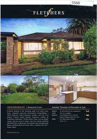 Greensborough Historical Society
Advertising leaflet, 1 Desmond Court Greensborough, 20/12/2012
1 Desmond Court Greensborough: 3 bedroom brick veneer home, auctioned 20 December 2012, sold for $212,000Real estate advertising leaflet, 1 sheet, printed in colour both sidesdesmond court greensborough -
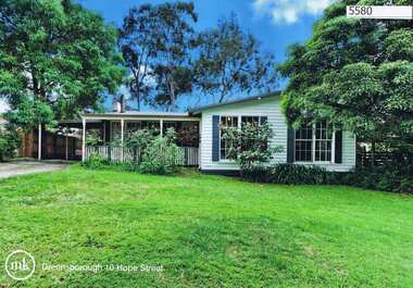 Greensborough Historical Society
Advertising Leaflet, 10 Hope Street Greensborough, 10/11/2012
10 Hope Street Greensborough, 4 bedroom home, auctioned 10 November 2012, sold March 2013 for $540,000, resold 18 October 2014 for $662,000 after minor renovationsReal estate advertising leaflet, 1 sheet, printed in colour both sideshope street greensborough -
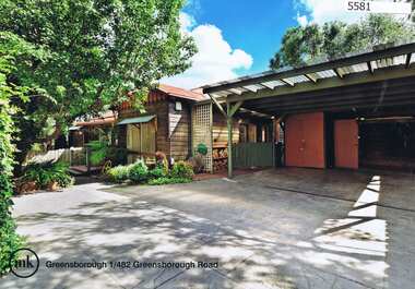 Greensborough Historical Society
Advertising Leaflet, 1/482 Greensborough Road Greensborough, 11/04/2015
1/482 Greensborough Road Greensborough, 3 bedroom home, auctioned 11 April 2015, sold for $459,000Real estate advertising leaflet, 1 sheet, printed in colour both sidesgreensborough road greensborough -
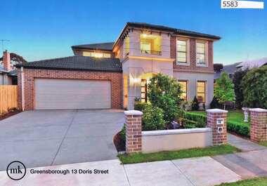 Greensborough Historical Society
Advertising Leaflet, 13 Doris Street Greensborough, 28/11/2015
13 Doris Street Greensborough, 4 bedroom home, auctioned on 28 November 2015, sold for $980,000Real estate advertising leaflet, 1 sheet, printed in colour both sidesdoris street greensborough -
 Greensborough Historical Society
Advertising leaflet, 3 Mahogany Court Greensborough, 15/08/2012
3 Mahogany Court Greensborough, 3 bedroom 2 storey home, sold 15/08/2012 for $630,000Real estate advertising leaflet, 1 sheet, printed in colour both sidesmahogany court greensborough -
 Greensborough Historical Society
Advertising Leaflet, 2/21 Ellen Court Greenhills, 2012_04
2/21 Ellen Court Greenhills, 3 bedroom home, sold April 2012 for $450,000Real estate advertising leaflet, 1 sheet, printed in colour both sidesellen court greensborough -
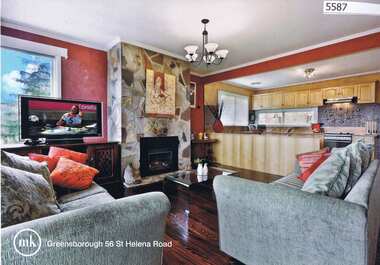 Greensborough Historical Society
Advertising Leaflet, 56 St Helena Road Greensborough, 04/09/2012
56 St Helena Road Greensborough, 3 bedroom home, sold September 2012 for $480,000; sold in August 2013 by Ray White Greensborough for $485,000Real Estate advertising leaflet, 1 sheet, printed both sides in colourst helena road greensborough -
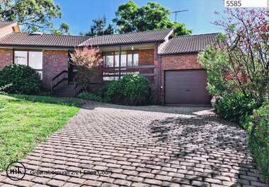
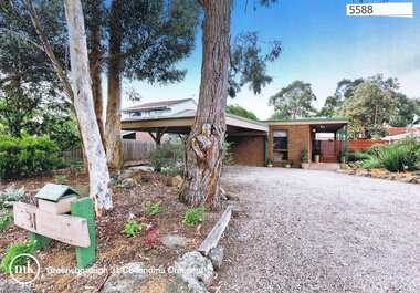 Greensborough Historical Society
Advertising Leaflet, 31 Collendina Crescent Greensborough, 21/12/2012
31 Collendina Crescent Greensborough, 3 bedroom home, sold 21 January 2012 for $490,000Real Estate advertising leaflet,1 sheet, printed in colour both sidescollendina crescent greensborough -
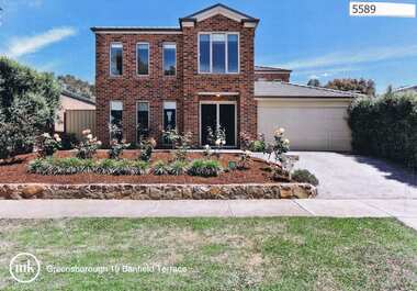 Greensborough Historical Society
Advertising Leaflet, Morrison Kleeman Real Estate, 19 Banfield Terrace Greensborough, 29/02/2012
19 Banfield Terrace Greensborough, 4 bedroom, 2 storey home, sold 29 February 2012 for $790,000Real Estate advertising leaflet, 1 sheet, printed in colour both sidesbanfield terrace greensborough -
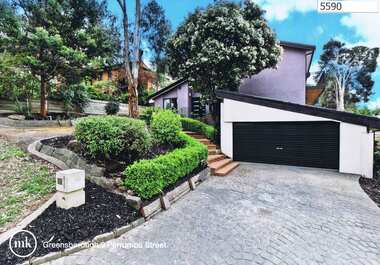 Greensborough Historical Society
Advertising Leaflet, 3 Perrumba Street Greensborough, 04/01/2013
3 Perrumba Street Greensborough, 5 bedroom home, sold 04/01/2013 for $690,000Real estate advertising leaflet, 1 sheet, printed in colour both sidesperrumba street greensborough -
 Greensborough Historical Society
Advertising Leaflet, 147 Karingal Drive Greensborough, 14/12/2012
147 Karingal Drive Greensborough, 3 bedroom home, sold 14/12/2012 for $470,000Real estate advertising leaflet, 1 sheet, printed in colour both sideskaringal drive greensborough -
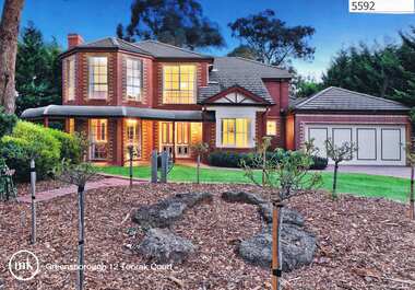 Greensborough Historical Society
Advertising Leaflet, 12 Toorak Court Greensborough, 06/10/2012
12 Toorak Court Greensborough, 2 storey, 4 bedroom home, sold at auction 6 October 2013 for $720,000Real estate advertising leaflet, 1 sheet, printed in colour both sidestoorak court greensborough -
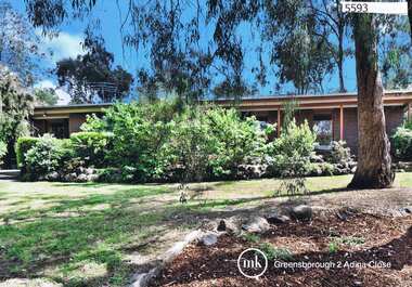 Greensborough Historical Society
Advertising Leaflet, 2 Adina Close Greensborough, 12/12/2012
2 Adina Close Greensborough, 4 bedroom home, sold November 2012 for $510,000Real estate advertising leaflet, 1 sheet, printed in colour both sidesadina close greensborough