Showing 716 items matching "public library -- melbourne"
-
 St Kilda Historical Society
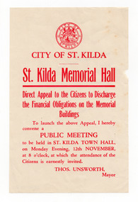
Ephemera - Flyer, St Kilda Memorial Hall Direct Appeal to the Citizens to Discharge the Financial Obligation on the Memorial Buildings, 1928
... St Kilda Historical Society St Kilda Branch Library 150 Carlisle Street St Kilda melbourne Notice of a public meeting at St Kilda Town Hall on 12 November1928 about the financing of the Memorial Buildings. ...Notice of a public meeting at St Kilda Town Hall on 12 November1928 about the financing of the Memorial Buildings. The year is not specified in the notice but it would have been 13 February 1929 because the Mayor is identified as Thos Unsworth, who served as Mayor in 1928-29. The Memorial Hall commemorates those who served in World War I, was officially opened on Armistice Day, 1924, and operated as a dance and social hall. In January 1927 the Health Department gave permission for it to operate as the Memorial Cinema. It continued as a cinema until 1957.White paper, discoloured with age, printed in redmemo, st kilda memorial hall -
 St Kilda Historical Society
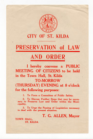
Ephemera - Flyer, Preservation of Law and Order
... St Kilda Historical Society St Kilda Branch Library 150 Carlisle Street St Kilda melbourne Notice of a public meeting on the preservation of law and order, called by the Mayor of St Kilda, TG Allen, to be held in St Kilda Town Hall. ...Notice of a public meeting on the preservation of law and order, called by the Mayor of St Kilda, TG Allen, to be held in St Kilda Town Hall. The notice is undated but TG Allen served two terms as Mayor: 1919-1920, and 1923-24.White paper, discoloured with age, printed in redcity of st kilda -
 St Kilda Historical Society
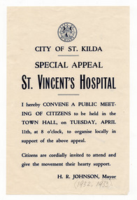
Ephemera - Flyer, Special Appeal St Vincent's Hospital, 1933
... St Kilda Historical Society St Kilda Branch Library 150 Carlisle Street St Kilda melbourne Notice of a public meeting convened by the St Kilda Mayor to organise support for a special appeal to raise funds for St Vincent's Hospital. ...Notice of a public meeting convened by the St Kilda Mayor to organise support for a special appeal to raise funds for St Vincent's Hospital. The full date is not given but is likely to have been 11 April 1933.White paper, discoloured with age, printed in bluehospital fundraising, st vincent's hospital, city of st kilda -
 St Kilda Historical Society
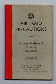
Booklet - Manual, Air Raid Precautions: Manual of General Training, 1939
... Library 150 Carlisle Street St Kilda melbourne Issued by the Victorian State Emergency Council for Civil Defence upon the outbreak of World War II. WWII World War II Air raid precautions From introduction: 'a condensed summary of the contents of numerous handbooks which have been issued in relation to the protection of the general public and the precautions which should be taken against the effects of an air raid. ...From introduction: 'a condensed summary of the contents of numerous handbooks which have been issued in relation to the protection of the general public and the precautions which should be taken against the effects of an air raid. It has been prepared so that, for reference purposes, trainees may have the main points of all the various phases of this complex subject embraced in one small volume.' Contains chapters on types of bombs, poison war gases and other poisonous substances, protective clothing, preparation of a refuge room, first aid, nursing of gassed patients, decontamination.Grey paperboard cover, 64pp, bound with staples and red bookbinding tape.non-fictionFrom introduction: 'a condensed summary of the contents of numerous handbooks which have been issued in relation to the protection of the general public and the precautions which should be taken against the effects of an air raid. It has been prepared so that, for reference purposes, trainees may have the main points of all the various phases of this complex subject embraced in one small volume.' Contains chapters on types of bombs, poison war gases and other poisonous substances, protective clothing, preparation of a refuge room, first aid, nursing of gassed patients, decontamination.wwii, world war ii, air raid precautions -
 St Kilda Historical Society
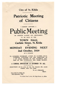
Ephemera - Flyer, Patriotic Meeting of Citizens, 1939
... St Kilda Historical Society St Kilda Branch Library 150 Carlisle Street St Kilda melbourne Notice of a public meeting about local patriotic activities and the formation of a St Kilda Branch of the Red Cross. ...Notice of a public meeting about local patriotic activities and the formation of a St Kilda Branch of the Red Cross. The meeting was convened by the City of St Kilda and held in the St Kilda Town Hall on 2 October 1939, shortly after the outbreak of World War II.Cream coloured paper printed in black on one sidewwii fund-raising, city of st kilda, st kilda red cross, arnold colman -
 St Kilda Historical Society
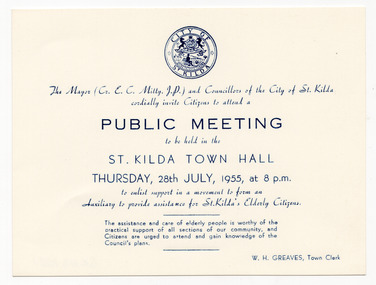
Ephemera - Invitation, Public Meeting, 1955
... St Kilda Historical Society St Kilda Branch Library 150 Carlisle Street St Kilda melbourne Invitation to citizens of St Kilda to attend a meeting about forming an Auxiliary to assist the elderly, to be held at St Kilda Town Hall at 8pm on 28 July 1955. Aged care City of St Kilda White card printed on blue on one side. Includes City of St Kilda logo. Public ...Invitation to citizens of St Kilda to attend a meeting about forming an Auxiliary to assist the elderly, to be held at St Kilda Town Hall at 8pm on 28 July 1955.White card printed on blue on one side. Includes City of St Kilda logo.aged care, city of st kilda -
 St Kilda Historical Society
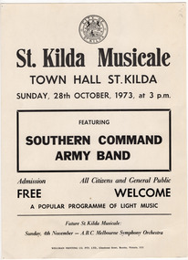
Ephemera - Poster, St Kilda Musicale featuring Southern Command Army Band, 1973
... St Kilda Historical Society St Kilda Branch Library 150 Carlisle Street St Kilda melbourne Poster for St Kilda Musicale at St Kilda Town Hall on 28 October 1973, featuring the Southern Command Army Band. Part of a program of light music presented by the City of St Kilda to the public for free. ...Poster for St Kilda Musicale at St Kilda Town Hall on 28 October 1973, featuring the Southern Command Army Band. Part of a program of light music presented by the City of St Kilda to the public for free.Buff coloured card printed in black on one sidest kilda musicales, city of st kilda, southern command army band -
 St Kilda Historical Society
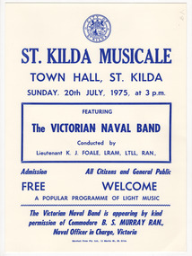
Ephemera - Poster, St Kilda Musicale featuring the Victorian Naval Band, 1975
... St Kilda Historical Society St Kilda Branch Library 150 Carlisle Street St Kilda melbourne Poster for St Kilda Musicale at St Kilda Town Hall on 20 July 1975, featuring the Victorian Naval Band. Part of a program of light music presented by the City of St Kilda to the public for free. ...Poster for St Kilda Musicale at St Kilda Town Hall on 20 July 1975, featuring the Victorian Naval Band. Part of a program of light music presented by the City of St Kilda to the public for free.Buff coloured card printed in blue on one sidest kilda musicales, city of st kilda, victorian naval band -
 St Kilda Historical Society
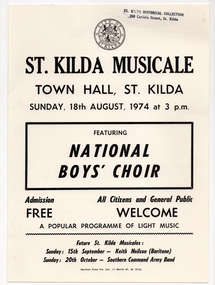
Ephemera - Poster, St Kilda Musicale featuring National Boys' Choir, 1974
... St Kilda Historical Society St Kilda Branch Library 150 Carlisle Street St Kilda melbourne Poster for St Kilda Musicale at St Kilda Town Hall on 18 August 1974, featuring the National Boys' Choir. Part of a program of light music presented by the City of St Kilda to the public for free. ...Poster for St Kilda Musicale at St Kilda Town Hall on 18 August 1974, featuring the National Boys' Choir. Part of a program of light music presented by the City of St Kilda to the public for free.Buff coloured card printed in black on one sidest kilda musicales, city of st kilda, national boys' choir -
 St Kilda Historical Society
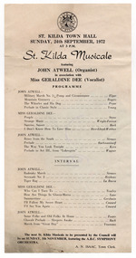
Ephemera - Concert program, St Kilda Musicale featuring John Atwell (Organist) in association with Miss Geraldine Dee (Vocalist), 1972
... St Kilda Historical Society St Kilda Branch Library 150 Carlisle Street St Kilda melbourne Program for St Kilda Musicale at St Kilda Town Hall on 24 September 1972, featuring organist John Atwell and vocalist Geraldine Dee. Part of a program of light music presented by the City of St Kilda to the public ...Program for St Kilda Musicale at St Kilda Town Hall on 24 September 1972, featuring organist John Atwell and vocalist Geraldine Dee. Part of a program of light music presented by the City of St Kilda to the public for free.White paper, discoloured with age, printed in black on one sidest kilda musicales, city of st kilda, john atwell, geraldine dee -
 St Kilda Historical Society
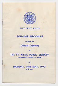
Souvenir - Brochure, Souvenir Brochure to mark the Official Opening of the St. Kilda Public Library, 1973
... St Kilda Historical Society St Kilda Branch Library 150 Carlisle Street St Kilda melbourne Souvenir brochure to mark the official opening of St Kilda Public Library on 14 May 1973 by Sir Rohan Delacombe, State Governor. ...Souvenir brochure to mark the official opening of St Kilda Public Library on 14 May 1973 by Sir Rohan Delacombe, State Governor. Includes information about the the establishment of the library, its holdings and services; details about the construction and fitout of the building; a floor plan; and members of the Council, Library Sub-Committee and library staff.Eight-page brochure with a white card cover, discoloured with age, printed in blue.st kilda public library -
 St Kilda Historical Society
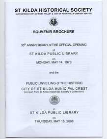
Souvenir - Brochure, 35th anniversary of the official opening of St Kilda Public Library on Monday, May 14, 1973, 2008
... St Kilda Historical Society St Kilda Branch Library 150 Carlisle Street St Kilda melbourne Souvenir brochure published by the St Kilda Historical Society to mark the 35th anniversary of the official opening of the St Kilda library and the public unveiling of the City of St Kilda municipal crest (mounted on an internal library wall) on 15 May 2008. ...Souvenir brochure published by the St Kilda Historical Society to mark the 35th anniversary of the official opening of the St Kilda library and the public unveiling of the City of St Kilda municipal crest (mounted on an internal library wall) on 15 May 2008. The brochure contains information about the establishment of a library in St Kilda, the library building itself, members of the City of St Kilda Council at the time that the library was opened, current members of the Port Phillip City Council, and the City of St Kilda Crest.20 page brochure of white paper printed in black and stapledst kilda library, st kilda crest -
 St Kilda Historical Society
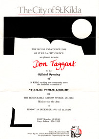
Ephemera - Invitation, Official Opening of extension to St Kilda Public Library, 1993
... St Kilda Historical Society St Kilda Branch Library 150 Carlisle Street St Kilda melbourne Invitation to the official opening of an extension to the St Kilda Public Library by the Victorian Minister for the Arts, the Hon Haddon Storey QC MLC, on 19 December 1993. ...Invitation to the official opening of an extension to the St Kilda Public Library by the Victorian Minister for the Arts, the Hon Haddon Storey QC MLC, on 19 December 1993. The floor area of the library was enlarged to include a new entry, ramp, and a pedestrian thoroughfare extending between Carlisle and Duke streets. The original entry was was blocked and a bluestone screen wall, evoking the form of an open book, was introduced to the west of new entry. Single sheet of white paper printed in grey, black and red, with St Kilda logoDon Taggart (invitee) st kilda town hall, st kilda town hall fire -
 St Kilda Historical Society
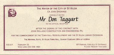
Ephemera - Invitation, Reception for the commencement of the town hall development and the St Kilda Public Library extension, 1992
... St Kilda Historical Society St Kilda Branch Library 150 Carlisle Street St Kilda melbourne Invitation from St Kilda Mayor John Spierings to Don Taggart, the President of the SKHS Historical Society, to a reception on 28 February 1992 after the signing of a contract for works on the St Kilda Town Hall and Public Library. ...Invitation from St Kilda Mayor John Spierings to Don Taggart, the President of the SKHS Historical Society, to a reception on 28 February 1992 after the signing of a contract for works on the St Kilda Town Hall and Public Library. The extension to the St Kilda Public Library was officially opened on 19 December 1993. The redevelopment of St Kilda Town Hall was officially opened on 26 June 1994.Cream coloured card printed in brown, with St Kilda logoMr Don Taggart (invitee) st kilda town hall, st kilda library, st kilda mayor john spierings -
 St Kilda Historical Society
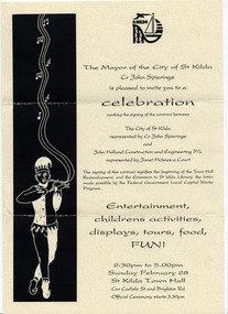
Ephemera - Flyer, Celebration marking the signing of a contract between the City of St Kilda and John Holland Construction, 1992
... St Kilda Historical Society St Kilda Branch Library 150 Carlisle Street St Kilda melbourne Invitation from St Kilda Mayor John Spierings to a celebration on 28 February 1992, including entertainment, children's activities, displays, tours and food, to mark the signing of a contract for works on the St Kilda Town Hall and Public Library. ...Invitation from St Kilda Mayor John Spierings to a celebration on 28 February 1992, including entertainment, children's activities, displays, tours and food, to mark the signing of a contract for works on the St Kilda Town Hall and Public Library. The extension to the St Kilda Public Library was officially opened on 19 December 1993. The redevelopment of St Kilda Town Hall was officially opened on 26 June 1994.Single sheet of cream coloured paper printed in black, with St Kilda logo. Illustration of a jester.st kilda town hall, st kilda library, st kilda mayor john spierings -
 St Kilda Historical Society
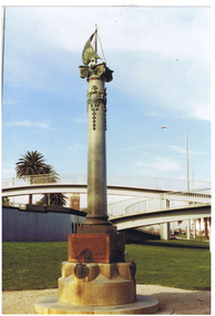
Photograph, Sali Cleve drinking fountain St Kilda - images collection, c. 1991
... Library 150 Carlisle Street St Kilda melbourne The drinking fountain is located in Catani Gardens, St Kilda. It was a gift to the City of St Kilda by Sali Cleve, a prominent local resident. It has aesthetic significance as a rare example of the Beaux-Arts style and is the only known public ...The drinking fountain is located in Catani Gardens, St Kilda. It was a gift to the City of St Kilda by Sali Cleve, a prominent local resident. It has aesthetic significance as a rare example of the Beaux-Arts style and is the only known public piece in bronze by noted architectural designer and artist Charles Adam Irwin. colour photograph, unmounted, good conditionThis Drinking Fountain is a Gift to the Public From Sali.Cleve.Esq. April, 1911st kilda, catani gardens, sali cleve, sali cleave drinking fountain, ca irwin, charles adam irwin, plaques -
 St Kilda Historical Society
Photograph, Carlo Catani Memorial Clock Tower unveiling, c1930, c. 1930-1931
... St Kilda Historical Society St Kilda Branch Library 150 Carlisle Street St Kilda melbourne Upper Esplanade, St Kilda Unveiling the memorial clock tower erected on the site formerly occupied by the bandstand, Upper Esplanade. Erected in memory of Carlo Catani, former Chief Engineer of the Public ...Upper Esplanade, St Kildablack and white photograph, original, mounted, good conditionUnveiling the memorial clock tower erected on the site formerly occupied by the bandstand, Upper Esplanade. Erected in memory of Carlo Catani, former Chief Engineer of the Public Works Department. Taken late 1930 or early 1931. Original photo held by St.K.C.C' c.74 -
 Koorie Heritage Trust
Booklet, Public Record Office Victoria, Walata tyamateetji - a guide to government records about Aboriginal people in Victoria, 2014
... melbourne Aboriginal Australians -- Victoria -- History -- Sources -- Bibliography. | Public records -- Victoria -- Bibliography. | Aboriginal Australians -- Victoria -- Archives. | Archives -- Victoria -- Catalogs. | Aboriginal Australians -- Victoria -- Government relations -- History. | Archives and archiving - Manuscripts and records. | Libraries - Reference materials - Bibliographies Australian This guide is designed to help researchers find records about Aboriginal people in Victoria in both the Public Reccords and Nationl Archives. ...This guide is designed to help researchers find records about Aboriginal people in Victoria in both the Public Reccords and Nationl Archives. It focuses on records that are specifically about Aboriginal people and issues, and inclues records created by the various government agencises overseeing the administration of Aboriginal affairs in Victoria. Public Record Office Victoria and the National Archives of Australia hold many government records about Aboriginal people in Victoria. This guide is designed to help Victorian Aboriginal people find records about their family and country. It will also assist anyone researching the history and administration of Aboriginal affairs in Victoria to find relevant records.87 pages : illustrations (some colour), maps, facsimiles ; 30 cm.This guide is designed to help researchers find records about Aboriginal people in Victoria in both the Public Reccords and Nationl Archives. It focuses on records that are specifically about Aboriginal people and issues, and inclues records created by the various government agencises overseeing the administration of Aboriginal affairs in Victoria. Public Record Office Victoria and the National Archives of Australia hold many government records about Aboriginal people in Victoria. This guide is designed to help Victorian Aboriginal people find records about their family and country. It will also assist anyone researching the history and administration of Aboriginal affairs in Victoria to find relevant records.aboriginal australians -- victoria -- history -- sources -- bibliography. | public records -- victoria -- bibliography. | aboriginal australians -- victoria -- archives. | archives -- victoria -- catalogs. | aboriginal australians -- victoria -- government relations -- history. | archives and archiving - manuscripts and records. | libraries - reference materials - bibliographies australian -
Koorie Heritage Trust
Book, Billot, C. P. (Cecil Philip), John Batman : the story of John Batman and the founding of Melbourne, 1979
... Founder of Melbourne no biography since 1867, the manner of his death may be the reason. Documentary works from a variety of primary sources in State libraries and Public Records have assisted in this work. xiii, 330 p., 8 p. of plates : ill., maps, ports. ; 24 cm. ...Founder of Melbourne no biography since 1867, the manner of his death may be the reason. Documentary works from a variety of primary sources in State libraries and Public Records have assisted in this work.xiii, 330 p., 8 p. of plates : ill., maps, ports. ; 24 cm.Founder of Melbourne no biography since 1867, the manner of his death may be the reason. Documentary works from a variety of primary sources in State libraries and Public Records have assisted in this work.batman, john, 1801-1839. | victoria. port phillip bay region. settlement. batman, john, 1801-1939. biographies. | land settlement -- victoria -- port phillip bay district. | port phillip bay region (vic.) -- history. -
Koorie Heritage Trust
Book, Boys, Robert Douglass, First years at Port Phillip : preceded by a summary of historical events from 1768, 1935
... Melbourne. In order to provide the necessary historical perspective, the Chronology has been preceded by a Summary of Historical Events.Many matters are here noted for the first time, and, through the courtesy of the Trustees of the Public Library of Victoria, the compiler was allowed to publish in full the diary kept by Sir Richard Bourke during his visit to Port Phillip in March, 1837.In addition to the authorities quoted in the text, recourse has been had to the large collection of official documents in the Public Library of Victoria (including the collection of La Trobe papers), the Historical Records of Australia, and the books and pamphlets dealing with the first decade of this State. 159 p., [4] leaves of plates : ill. ; index; 22 cm. ...Foreword: This Chronology extends from the first permanent settlement of "Port Phillip" or "Australia Felix," at Portland Bay, by Edward Henty, until the beginning of the proceedings of the first Town Council of Melbourne. In order to provide the necessary historical perspective, the Chronology has been preceded by a Summary of Historical Events. Many matters are here noted for the first time, and, through the courtesy of the Trustees of the Public Library of Victoria, the compiler was allowed to publish in full the diary kept by Sir Richard Bourke during his visit to Port Phillip in March, 1837. In addition to the authorities quoted in the text, recourse has been had to the large collection of official documents in the Public Library of Victoria (including the collection of La Trobe papers), the Historical Records of Australia, and the books and pamphlets dealing with the first decade of this State.159 p., [4] leaves of plates : ill. ; index; 22 cm.Foreword: This Chronology extends from the first permanent settlement of "Port Phillip" or "Australia Felix," at Portland Bay, by Edward Henty, until the beginning of the proceedings of the first Town Council of Melbourne. In order to provide the necessary historical perspective, the Chronology has been preceded by a Summary of Historical Events. Many matters are here noted for the first time, and, through the courtesy of the Trustees of the Public Library of Victoria, the compiler was allowed to publish in full the diary kept by Sir Richard Bourke during his visit to Port Phillip in March, 1837. In addition to the authorities quoted in the text, recourse has been had to the large collection of official documents in the Public Library of Victoria (including the collection of La Trobe papers), the Historical Records of Australia, and the books and pamphlets dealing with the first decade of this State.victoria -- history -- 1834-1851. | victoria -- history -- to 1834. -
 Nillumbik Shire Council
Drawing (Pastel): Nicholas Nedelkopoulos (b.1955 Melb, AUS), Nicholas Nedelkopoulos, The Sneeze, 1995
... Public and Private Collections. His work has been included in major historic exhibitions: the National Gallery of Australia's Federation touring exhibition, The Australian Bicentennial Folio and Victoria's 150th Anniversary exhibition curated at The State Library of Victoria and National Gallery of Victoria. He has a Diploma of Fine Arts from Victorian College of the Arts, a Master of Fine Art from the University of Melbourne...Nillumbik Shire Council melbourne Nicholas Nedelkopoulos is an established artist, his work is represented in the Metropolitan Museum of Art, New York, the National Gallery of Australia and in numerous International and Australian Public and Private Collections. His work has been included in major historic exhibitions: the National Gallery of Australia's Federation touring exhibition, The Australian Bicentennial Folio and Victoria's 150th Anniversary exhibition curated at The State Library of Victoria and National Gallery of Victoria. ...Nicholas Nedelkopoulos is an established artist, his work is represented in the Metropolitan Museum of Art, New York, the National Gallery of Australia and in numerous International and Australian Public and Private Collections. His work has been included in major historic exhibitions: the National Gallery of Australia's Federation touring exhibition, The Australian Bicentennial Folio and Victoria's 150th Anniversary exhibition curated at The State Library of Victoria and National Gallery of Victoria. He has a Diploma of Fine Arts from Victorian College of the Arts, a Master of Fine Art from the University of Melbourne (Victorian College of the Arts) and has a Doctorate from Monash University. Nedelkopoulos' work is based strongly in graphic tradition which can be seen throughout all of his media.'The Sneeze' alludes to a feverish response, an irritation, a period of temporary discomfort, or a sign of sickness. On a visit to Eltham in 1995 Nedelkopoulos became aware of the disquiet felt by many residents because local government was not in the hands of elected representatives. 'The Sneeze' is an allegorical work, which serves as a reminder of this period in our municipal history. Nedelkopoulos has constructed an environment similar to a theatre set in which every element is a symbol to be deciphered. Whether you read the red-nosed figure as democracy being challenged by the political circumstance, as representing the unelected commissioners surrounded by the criticism of the community, or as another player in the story, to unravel the meaning of individual elements will provide direction and add weight to your interpretation. Without knowledge of the artist's intention the work can convey quite straightforward messages and responses. For example, the misery of hayfever in Spring, or how germs spread from a single sneeze. Such ideas are relevant and provide the metaphoric basis for a more in-depth analysis.Pastel drawing on paper. Image depicts a small black figure with a small monkey on a lead. The figure has a red nose to which he is holding a tissue. He is walking through what appears to be a flowering forest.nedelkopoulos, the sneeze -
 Nillumbik Shire Council
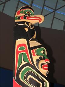
Public Art: Wayne ALFRED (b.1958 Alert Bay, British Columbia), Wayne Alfred C/- High Commision of Canada, Commonwealth Games Totem Pole, Location: Eltham Library Foyer, Panther Place, Eltham, 2006
... public art kwakwaka'wakw namgis alfred north pacific coast british columbia canada totem pole carved commonwealth games melbourne festival cedar No inscriptions. Bold cuts used to outline the characters and symbols as well as decorative and stylised features all over the pole. Carved in cedar wood, this totem pole incorporates bold cuts and colours (such as red and green) offset by strong black. A relative degree of realism is used to depict the alligator located on the bottom of the pole, a man and a 'thunderbird'/eagle located on the top. With protuding element. Commonwealth Games Totem Pole, Location: Eltham Library ...Wayne Alfred is a member of the Namgis Tribe of the Kwakwaka'wakw people. As a master carver he has an extremely high level of carving skill and knowledge about his peoples cultural objects, customs, tribal stories and legends. The Totem Poles of the North Pacific Coast in British Columbia and Alaska are traditionally carved out of red or yellow cedar, which has a spiritual and practical purpose. The wood was known for its durability, its resistance to rotting and the inner bark was utilised in ropemaking, clothing, hats, baskets and so forth. The Kwakitul People consider the cedar tree to be among the most sacred of all things provided by the Creator. They believed the Cedar tree to be the axis of the world and a pathway to the upper world. The wood is shaped using implements such as adzes, axes, chisels, carving knives, and chainsaws. Misinterpreted as Gods and idols to be worshipped, totems usually serve six purposes, such as a house pillar for support, a memorial or mortuary pole to commemorate (and house) the deceased, a potlatch pole (used for important traditional indigenous celebrations), a ridicule pole used to shame and a heraldic or family crest pole. Characters and symbols on these totem poles usually display family crests, history, wealth, social rank, inheritance, and privilege, as well as animalistic imagery derived from native animals and mythological creatures. Their sequence are indicative of past family events, ancestors, myths, and heraldic crests, with the bottom figure usually being the most prominent. In this work the 'thunderbird' is symbolic of power, strength and of ancestory. The Commonwealth Games Totem Pole was presented to the people of Nillumbik on behalf of the Canadian Government in recognition of Melbourne as the hosts of the Melbourne Commonwealth Games Team in 2006. Carved in cedar wood, this totem pole incorporates bold cuts and colours (such as red and green) offset by strong black. A relative degree of realism is used to depict the alligator located on the bottom of the pole, a man and a 'thunderbird'/eagle located on the top. With protuding element. No inscriptions. Bold cuts used to outline the characters and symbols as well as decorative and stylised features all over the pole. public art, kwakwaka'wakw, namgis, alfred, north pacific coast, british columbia, canada, totem pole, carved, commonwealth games, melbourne festival, cedar -
 Nillumbik Shire Council
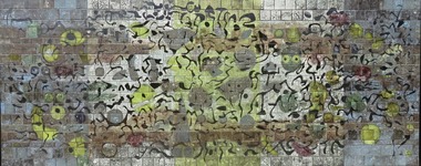
Public Art: Tom SANDERS (b.1925-d.2008 Vic, Aus), Tom Sanders, Wall of the Moon (Homage to Miro) - (Location: Eltham Town Square, Arthur Street, Eltham), 1968
... After returning from his travels in Europe to Australia in 1964, he began to work solely on creating ceramic murals, some of which were commissioned for Southland Shopping Centre in Cheltenham, Melbourne, 1968 (now demolished), the National Mutual Centre, Melbourne,1964-5 (now demolished), Dee Why Library, Sydney 1966, Woden Valley High School, ACT, 1967, Tullamarine Airport Melbourne, 1969-70 (now demolished), Perth Concert Hall, 1971 and The University of Melbourne,1975 (with John Olsen). This mural is one of only three remaining in the public ...Sanders was a well-known local potter who worked for a time with David Boyd at the Martin Boyd Pottery, before returning to Melbourne where he had some association with Arthur Boyd, at the pottery in Murrumbeena. Sanders set up a studio in Eltham in the early 1950s and made the first of a series of architectural ceramic murals with painter and print maker Lawrence Daws in 1956. In 1957 he left for Europe and while there was inspired by the Spanish artist Joan Miro’s unconventional painting style and large scale murals, in particular Wall of the Moon (1957). After returning from his travels in Europe to Australia in 1964, he began to work solely on creating ceramic murals, some of which were commissioned for Southland Shopping Centre in Cheltenham, Melbourne, 1968 (now demolished), the National Mutual Centre, Melbourne,1964-5 (now demolished), Dee Why Library, Sydney 1966, Woden Valley High School, ACT, 1967, Tullamarine Airport Melbourne, 1969-70 (now demolished), Perth Concert Hall, 1971 and The University of Melbourne,1975 (with John Olsen). This mural is one of only three remaining in the public realm by Tom Sanders (the others are at the Perth Concert Hall (1971) and at the University of Melbourne (1975). Ceramic mural (earthenware tiles) consisting of a playful/organic abstract design similar in style to the Spanish artist Joan Miro. Shades of blue, yellow and black glazes are layered onto matte black and shiny bronze tiles. N/Amural, public art, earthernware, pottery, ceramics, glaze, eltham, ekphrasis2017, eltham town square, joan miro -
Whitehorse Historical Society Inc.
Article, Margaret Chadwick, 2/02/1993 12:00:00 AM
... Whitehorse Historical Society Inc. 2-10 Deep Creek Road Mitcham melbourne Awarded Public Service Medal for her service to the adult literacy program at Blackburn Library. ...Article from Nunawading Gazette about Margaret Chadwick.Article from Nunawading Gazette about Margaret Chadwick, awarded Public Service Medal for her service to the adult literacy program at Blackburn Library.Article from Nunawading Gazette about Margaret Chadwick.chadwick, margaret, adult literacy program, blackburn branch library -
![Vital Connections: Melbourne and its Board of Works 1891-1991 / [by] A.E. Dingle](/media/collectors/550653872162f11fb04854aa/items/5ece65f9f36c2704c4f2b67b/item-media/5ece66eef36c2704c4f2b783/item-fit-380x285.jpg?cb=6) Kew Historical Society Inc
Kew Historical Society IncBook, A.E. Dingle, Vital Connections: Melbourne and its Board of Works 1891-1991, 1991
... Kew Historical Society Inc Kew Court House 188 High Street Kew melbourne History of urban planning by the MMBW in Victoria which provided public services in sewerage and water reticulation The history will add value to the important original series of MMBW plans in the KHS collection melbourne and metropolitan board of works -- history. melbourne (vic.) -- public works -- history. cartography Ex Library copy Ringwood, Vic. : McPhee Gribble, 1991 432 p. : ill. ...Ringwood, Vic. : McPhee Gribble, 1991 432 p. : ill. (some col.), maps, ports. ; 25 cm. non-fictionmelbourne and metropolitan board of works -- history., melbourne (vic.) -- public works -- history., cartography -
![Colonial Consorts: The wives of Victoria's Governors 1839-1900 / [by] Marguerite Hancock](/media/collectors/550653872162f11fb04854aa/items/5ed05c0fdcf9cd08346c4ced/item-media/5ed05cbddcf9cd08346c5235/item-fit-380x285.jpg?cb=6) Kew Historical Society Inc
Kew Historical Society IncBook, Colonial Consorts: The wives of Victoria's Governors 1839-1900 / [by] Marguerite Hancock, 2001
... public service for women in colonial Australia. Victoria had ten British governors during the nineteenth century, and all were married men. (One of them, Sir Henry Barkly, was married twice.) Their wives accompanied them to Melbourne as a matter of course, forced to leave behind their homes, their extended families and sometimes their school-age children. While researching Colonial Consorts, Marguerite Hancock made extensive use of letters, diaries, and family papers in libraries...melbourne Carrying out the duties of a governor’s wife was the pinnacle of public service for women in colonial Australia. Victoria had ten British governors during the nineteenth century, and all were married men. (One of them, Sir Henry Barkly, was married twice.) Their wives accompanied them to Melbourne as a matter of course, forced to leave behind their homes, their extended families and sometimes their school-age children. While researching Colonial Consorts, Marguerite Hancock made extensive use of letters, diaries, and family papers in libraries ...xxii, 324 p., [10] p. of plates : ill. (some col.), ports., photos. ; 25 cm.non-fictiongovernors' spouses -- victoria -- history -- 19th century., victoria -- politics and government -- 1834-1900. -
 Kew Historical Society Inc
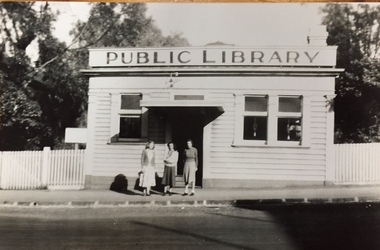
Photograph - Print Copy, Public Library, Walpole Street, Kew
... melbourne In a letter accompanying the donation, the donor writes "I am enclosing a photograph ... I have now established that Emma Murray has a daughter Alma who was also a librarian and probably took the photo." A rare image of the Kew Library in Walpole Street after it had been renovated. The Library was situated beside the Town Hall. municipal libraries - kew kew municipal library - walpole street *(kew) On reverse of original: "5/4/49, MIRI DICKINSON, MARIE DICKENS, BERYL OAKES AT KEW LIBRARY Black and white print made from an original in the possession of the donor Public Library, Walpole Street, Kew Photograph Print Copy ...In a letter accompanying the donation, the donor writes "I am enclosing a photograph ... I have now established that Emma Murray has a daughter Alma who was also a librarian and probably took the photo."A rare image of the Kew Library in Walpole Street after it had been renovated. The Library was situated beside the Town Hall.Black and white print made from an original in the possession of the donorOn reverse of original: "5/4/49, MIRI DICKINSON, MARIE DICKENS, BERYL OAKES AT KEW LIBRARYmunicipal libraries - kew, kew municipal library - walpole street *(kew) -
Kew Historical Society Inc
Book, Australian Council of National Trusts, Historic Houses, 1982
... melbourne Kew Historical Society, founded in 1958, has an extensive reference library, of which this book is a part. Volumes in the library are used by members for research into aspects of local history and/or to support the Society's collections of pictures, maps, fashion and artefacts. Reference books have entered the collection through donation, presentation, collection and purchase. Houses of historical importance --Australia Historic buildings -- Australia. Originally published in 2 separate v.: Historic public ...Originally published in 2 separate v.: Historic public buildings of Australia; and, Historic houses of Australia. North Melbourne : Cassell Australia, 1971 and 1974.Canberra City : Australian Council of National Trusts, 1982, c1974 604 p. : ill. (some col.), plans ; 32 cm. non-fictionOriginally published in 2 separate v.: Historic public buildings of Australia; and, Historic houses of Australia. North Melbourne : Cassell Australia, 1971 and 1974.houses of historical importance --australia, historic buildings -- australia. -
Kew Historical Society Inc
Book, Prof E W Russell, A Matter of Record: A history of Public Record Office Victoria, 2003
... melbourne Kew Historical Society, founded in 1958, has an extensive reference library, of which this book is a part. Volumes in the library are used by members for research into aspects of local history and/or to support the Society's collections of pictures, maps, fashion and artefacts. Reference books have entered the collection through donation, presentation, collection and purchase. Victoria - Public ...xi, 227 p. : ill., ports. ; 25 cm.non-fictionvictoria - public record office - history, public records - victoria - history, archives - victoria - history -
 Whitehorse Historical Society Inc.
Memorabilia - Periodical, Library News, 1/03/2017 12:00:00 AM
... Whitehorse Historical Society Inc. 2-10 Deep Creek Road Mitcham melbourne whitehorse manningham regional library corporation libraries public libraries marion edwina Whitehorse Manningham Libraries Periodical Issue 1, 2017 Whitehorse Manningham Libraries Periodical Issue 1, 2017 containing an article on 8 local remarkable women of the late nineteenth and early twentieth centuries. ...Whitehorse Manningham Libraries Periodical Issue 1, 2017Whitehorse Manningham Libraries Periodical Issue 1, 2017 containing an article on 8 local remarkable women of the late nineteenth and early twentieth centuries.Whitehorse Manningham Libraries Periodical Issue 1, 2017whitehorse manningham regional library corporation, libraries, public libraries, marion, edwina