Showing 4273 items
matching street plan
-
 Greensborough Historical Society
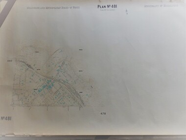
Map, Municipality of Heidelberg Plan No. 481, 23/9/1949
Central area of Greensborough, South boundary Grimshaw Street, showing river and buildings in green and gradients in red. Adjoins Map No. 480 to West.Black & white map with features in red and green. Scale: 160 feet to 1 inch.greensborough, grimshaw street greensborough -
 Greensborough Historical Society
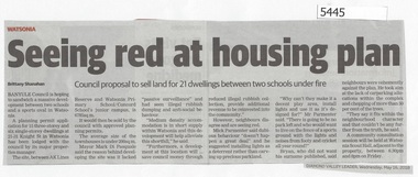
Newspaper Clipping, Diamond Valley Leader, Seeing Red at Housing Plan, 16/05/2018
Banyule Council is hoping to sandwich a massive development between two schools and a sports oval in Watsonia.News article 1 page, black text.watsonia, knight street watsonia, concord school, watsonia primary school, residential development, banyule city council -
 Greensborough Historical Society
Newspaper Clipping, Diamond Valley Leader, Safety concerns, 18/07/2018
A planning application for a double storey childcare and medical centre to be built at the intersection of Grimshaw Street and Macorna Street has left the community seeing red.News article 1 page, black text.childcare centre, watsonia north, grimshaw street watsonia, macorna street watsonia -
 Greensborough Historical Society
Newspaper Clipping, Diamond Valley Leader, Proposal rejected, 25/07/2018
Banyule Council has refused a planning permit application that would have seen a double-storey childcare and medical centre built at a bustling intersection in Grimshaw Street Watsonia.News article 1 page, black text.watsonia, childcare centre, grimshaw street watsonia, macorna street watsonia, banyule city council -
 Glenelg Shire Council Cultural Collection
Administrative record - Plans, n.d
Black and white photocopy of old plan of subdivision, same as 8398, 8399, smaller scale, numerous notations, added by Vanda Savill. -
 Glenelg Shire Council Cultural Collection
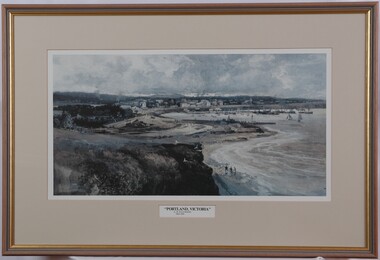
Print, Albert Henry Fullwood, Portland Victoria, c. 1886
Scene of Portland Harbour. View includes people walking on beaches, jetties, morred boats (some with sails, some without). Upper centre of image shows a town, with a church to the right. To the left centre is a planned garden with people promenading. In foreground is empty land with a few seagulls. A train track enters the image on bottom centre. Print is predominantly in shades of blue, grey and brown. Framed, no glass.Front: A. H. Fullwood Back: (no insciptions)print, portland harbour -
 Greensborough Historical Society
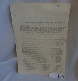
Manuscript, Late Thoughts! by June Roberts, 1958-1978
This was prepared by June Roberts with assistance from Grace Cavill. Written in 1978 it includes details of Greensborough's Main Street from circa 1958-1978.Describes the locations of the Main Street traders in the 1950s. Also mentions the efforts needed to replace the Plenty River footbridge after it was washed away in a flood.A 3 page typed manuscript and a hand drawn plan of Greensborough shopping area based on the document.Sept 78 in blue biro on front page.main street shops, tom vickers, hume street, griffiths haberdashery, popes, flintoff street, plenty river bridge, stubleys hardware, stan ashleys menswear, hume street residences, rob willett, ashril theatre -
 Greensborough Historical Society
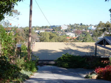
Photograph - Digital image, View of Greensborough from Delfin Crescent, 02/05/2013
This photograph of Greensborough was taken from Delfin Crescent in 2013 to show changes over 40 years, based on Ron Reynold’s sketches in the 1973 publication “Greensborough and Greenhills” published by Cypress Books. Delphin Crescent [previously known as Medhurst Street] was created about 1970 in association with the Delfin Building Company. It was at this time also, that major works on Diamond Creek Road raised the level of the road facilitating the connection of Delfin Crescent with Diamond Creek Road. [Note: 'Medhurst Street was only listed on planning maps pre 1950 when the 'street' had no residents or development.]Digital copy of colour photograph.greensborough and greenhills -
 Greensborough Historical Society
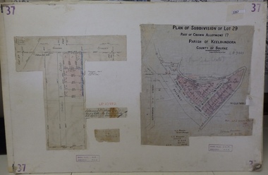
Planning Document, Subdivision Plan # 37. Poulter Avenue and Bicton Street; and, Adeline Street and Grimshaw Street Greensborough, 1971_
... Street. An example of hard copy subdivision plans from ...Plan of subdivision Lot 29, Part of Crown Allotment, Parish of Keelbundoora, County of Bourke. Poulter Avenue and Bicton Street; and, Adeline Street and Grimshaw Street.An example of hard copy subdivision plans from the Greensborough area. Mainly from the Shire of Diamond Valley era (1964-1994).Plan (2 sheets) mounted on heavy card. subdivision plans, grimshaw street, poulter avenue, adeline street -
 Greensborough Historical Society
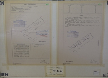
Planning Document, Subdivision Plan #1034. 50 Hume Street, 03/02/1982
... Subdivision Plan #1034. 50 Hume Street. ... Street. Planning Document N A Webster and Associates ...Plan of Strata Subdivision at 50 Hume Street Greensborough for 7 units.An example of hard copy subdivision plans from the Greensborough area. Mainly from the Shire of Diamond Valley era (1964-1994).Plan (2 sheets) mounted on heavy card.Stamped and handwritten Council permissions, dates and other details.subdivision plan -
 Greensborough Historical Society
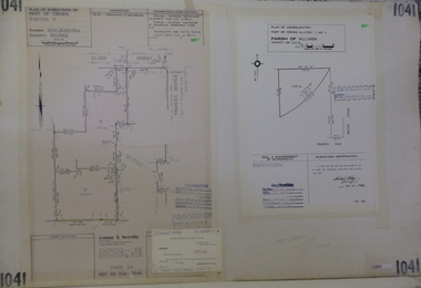
Planning Document, Subdivision Plan #1041. Elder Street Greensborough, 20/04/1983
... Subdivision Plan #1041. Elder Street Greensborough . ... Street. An example of hard copy subdivision plans from ...Plan of Consolidation of Allotments 3 and 4 Brixton Avenue and Plan of Subdivision for Elder Street. An example of hard copy subdivision plans from the Greensborough area. Mainly from the Shire of Diamond Valley era (1964-1994).Plan (2 sheets) mounted on heavy card.Stamped and handwritten Council permissions, dates and other details.subdivision plans, elder street, brixton avenue -
 Greensborough Historical Society
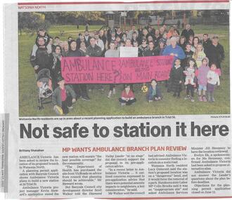
Newspaper clipping, Not safe to station it here, 17/06/2015
Ambulance Victoria's plans to build a new station at Trist Street Watsonia North are to be reviewed, following residents' objections.News clipping, black text, colour image.ambulance victoria, trist street watsonia north -
 Greensborough Historical Society
Newspaper clipping, Building height set to be reduced by developers, 17/06/2015
... Flintoff Street is to have its plans amended to reduce the height ...A proposed development at 4-6 Flintoff Street is to have its plans amended to reduce the height of the building.News clipping, black text.flintoff street greensborough, town planning, banyule city council -
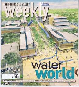 Greensborough Historical Society
Newspaper, Fairfax Media, Heidelberg and Valley Weekly. August 29 2006, 29/08/2006
This issue of the Heidelberg and Valley Weekly, (August 29 2006) includes a double page feature on the planned redevelopment of the Greensborough Town Centre.55 pages, colour images and black text. greensborough town centre, main street greensborough -
 Greensborough Historical Society
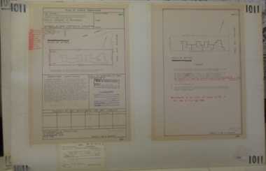
Planning document, Subdivision Plan #1011. Corner Mountainview Road and Hume Streets, 1981_
... ). subdivision plans mountainview road hume street Stamped ...Plan of Strata Subdivision for units at corner of Mountainview Road and Hume Street Briar Hill.An example of hard copy subdivision plans from the Greensborough area. Mainly from the Shire of Diamond Valley era (1964-1994).Plan (2 sheets) mounted on heavy card.Stamped and handwritten Council permissions, dates and other details.subdivision plans, mountainview road, hume street -
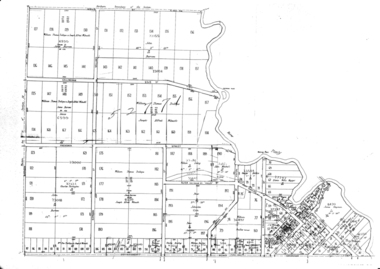
 Greensborough Historical Society
Map, City of Heidelberg, Subdivision plan of Greensborough, 1965c
Subdivision plan of Greensborough including Briar Hill and Greenhills. Supplied by Bill Cecil whose parents owned the Greensborough Post Office and it is assumed that these maps were used by Bill (who delivered the post on horseback) to keep up to date with the growing number of new streets and housing in Greensborough.Copies of subdivision plan for Greensboroughgreensborough, briar hill, greenhills -
![Document, Town Planning Appeals Tribunal, Town Planning Appeals Tribunal report 1978 [Loyola College], 06/11/1978](/media/collectors/4f729f5697f83e03086015b8/items/58bbb237d0cdef1bcc864955/item-media/58bbb35fd0cdef1bcc8683be/item-fit-380x285.jpg) Greensborough Historical Society
Greensborough Historical SocietyDocument, Town Planning Appeals Tribunal, Town Planning Appeals Tribunal report 1978 [Loyola College], 06/11/1978
Report on an appeal against two conditions on the development of land in Grimshaw Street Watsonia for a secondary school [Loyola College].This document demonstrates some of the problems associated with setting up a school in a residential area.3 pages, torn and yellowed.loyola college -
 Greensborough Historical Society
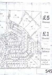
Advertisement, Greenhills Estate, 1923c
The advertisement was used to sell land in the Greenhills area.The plan included details the original street lay out and names applied to them. It also has dimensions of all the blocks of land available and locations and dimensions of easements.A 2 page A3 photoccopy of a real estate advertisement. Nilgreehills, subdivision plan, greensborough -
![Planning Document, Plan of proposed subdivision of land in Greensborough [Map shows Scotland house], 01/04/1971](/media/collectors/4f729f5697f83e03086015b8/items/5982a68921ea6b1420e4e560/item-media/59916fb521ea681094908d7a/item-fit-380x285.jpg) Greensborough Historical Society
Greensborough Historical SocietyPlanning Document, Plan of proposed subdivision of land in Greensborough [Map shows Scotland house], 01/04/1971
... bounded by Hailes, William, Lorimer, and Jessop Streets. john ...This subdivision of Greensborough shows the home of John Scotland (died 1888) and surrounding area bounded by Hailes, William, Lorimer, and Jessop Streets.Photocopy of plan, 2 pages.Part of plan (68G) of proposed subdivision of Greensborough, part of Crown Portion 18, Parish pf Keelbundora. Scale: 132 ft. to an inchjohn scotland, hailes street greensborough, william street greensborough, lorimer street greensborough, jessop street greensborough -
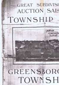 Greensborough Historical Society
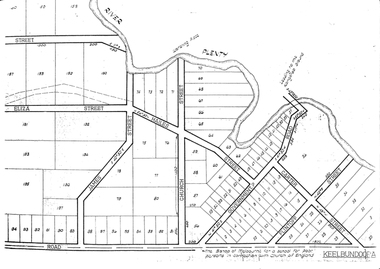
Plan, Greensborough Township Estate, 01/09/1923
Sub-division into 129 lots of land belonging to the Scotland Family, bounded by William Street, Eliza Street, James (Jessop) Street and south of Lorimer Street. Auction 1 September 1923Photocopy, double-sidedsubdivision plans, greensborough township estate, scotland family -
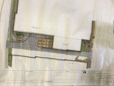 Greensborough Historical Society
Plan, TTM Consulting, Valley Central Shopping Centre, Myer Loading Area, 1993_11
... Plenty Lower Plenty melbourne Plan for the pavement finishes ...Plan for the pavement finishes at the Myer loading area at Valley Central Shopping Centre (now Greensborough Plaza) between The Circuit and Church Street.Plan of loading dock showing pavement finishes. Colour and black ink on white paper.greensborough plaza, the circuit greensborough, church street greensborough -
 Greensborough Historical Society
Map, Green's subdivision of Greensborough, 1860c
This map shows the original subdivision of Greensborough by Edward Bernard Green. Some street names are different to today. This map shows the plan on which the town of Greensborough was based.Copy of early map showing subdivision of Greensborough. Black ink on white paper.edward bernard green, greensborough -
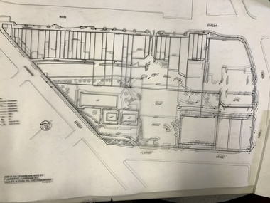 Greensborough Historical Society
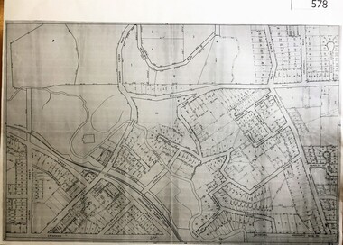
Planning Document, Banyule City Council, Site plan of Greensborough 1997, 28/07/1997
Site plans for the area bounded by Flintoff Street; Grimshaw Street; Main Street and Para Road Greensborough. these plans show the area before the development of Watermarc.This plan shows central Greensborough before the Watermarc developmentSet of 8 site plansgreensborough, greensborough swimming pool -
 Greensborough Historical Society
Map, Melbourne & Metropolitan Board of Works, MMBW Plan No.481, 23/09/1949
MMBW plan of part of central Greensborough, Main Street and surrounds, from sports ovals in North to Grimshaw Street in South.Map shows buildings and topography for the area.MMBW plan, black and colour ink on beige parchment, 2 copies."Scale:160 feet to 1 inch"melbourne and metropolitan board of works, mmbw, greensborough -
 Greensborough Historical Society
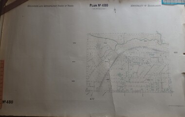
Map, Melbourne & Metropolitan Board of Works, MMBW Plan No.480, 17/10/1949
MMBW plan of part of central Greensborough, from Plenty River in North to Grimshaw Street in South, Sellars Street in West to Kerr Street in East.Map shows buildings and topography for the area.MMBW plan, black and colour ink on beige parchment, 4 copies."Scale:160 feet to 1 inch"melbourne and metropolitan board of works, mmbw, greensborough -
 Greensborough Historical Society
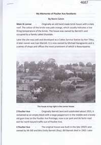
Article, Norm Colvin, My memories of Poulter Ave residents, by Norm Colvin, 28/07/2016
Details of the development and occupation of sites in Poulter Avenue and Bicton Street Greensborough, compiled by resident Norm Colvin.12 pages, text, black and white photographs and colour subdivision plan.poulter avenue greensborough, bicton street greensborough -
 Greensborough Historical Society
Maps, Greensborough. Parish Plan 1860, 1860c
... , and surrounding streets. Enlargements of Parish plan circa 1860 ...This plan show Green's subdivision of Greensborough, north of Grimshaw Street.Enlargements of Parish plan circa 1860?One copy possibly from 1860, containing lot numbers for a government road, now Main Street, and surrounding streets.greensborough, grimshaw street greensborough, edward bernard green -
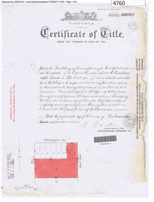 Greensborough Historical Society
Certificate of Title, Certificate of Title Vol. 3182 Fol. 302, 15/02/1907
Title in the name of Joseph Laidlay of Greensborough, fruitgrower, 14 acres being Lots 7, 8 and 22 on Plan of subdivision 4759, part of Crown portion 17, Parish of Keelbundora County of Bourke, dated 15th February 1907. Northern boundary Greensborough (now Grimshaw) Road, Eastern boundary Henry Street.1 p. colour copy of Titlegreensborough, grimshaw street greensborough, henry street greensborough, joseph laidlay -
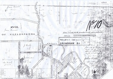 Greensborough Historical Society
Plan, Parish Plan Map of Land North of Grimshaw Street, 11/12/1879
... Plan Map of Land North of Grimshaw Street Plan ...Part of Parish plan of land north of Grimshaw Street bounded by the Plenty River. Includes annotation signed by John Scotland and J. W. Britnell, dated Dec. 11th 1879.Photocopy of part of Parish plan of land north of Grimshaw Street bounded by the Plenty River. Includes annotation signed by John Scotland and J. W. Britnell, dated Dec. 11th 1879greensborough, grimshaw street greensborough, jonah britnell, john scotland -
Glenelg Shire Council Cultural Collection
Plan - Plan - early Portland, n.d
Early plan drawing of PortlandHand-drawn plan on paper, glued on linen backing. Plan shows layout of properties and a lagoon. Hand-tinted in colour. Names of property owners written on lots.plan, map, town, portland