Showing 2417 items
matching townships
-
 Sunbury Family History and Heritage Society Inc.
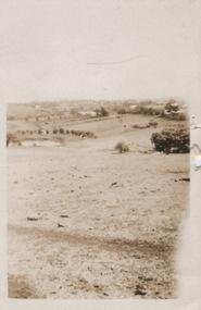
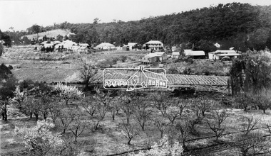
Photograph
A portrait view overlooking Sunbury township taken from a hill above the Goonawarra vineyard at the eastern end of the settlement. A sepia photograph with a cream frame of a portrait view of a rural landscape.sunbury township., goonawarra winery -
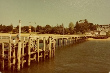 Phillip Island and District Historical Society Inc.
Photograph, Cowes jetty and Matthew Brady ferry, About 1980
Coloured photograph of the Cowes jetty, taken from the water, showing several men standing on the jetty and others fishing. Cowes township in the background. Coloured photograph of the passenger ferry, Matthew Brady at the Cowes jetty. A large number of passengers inside and on the top deck.cowes jetty, photographs, cowes, ferries, ferry matthew brady -
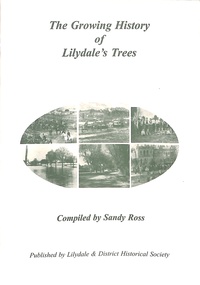 Ringwood and District Historical Society
Book, The Growing History of Lilydale's Trees, Circa 2010
Soft cover book by Sandy Ross - Lilydale & District Historical Society. Year by year summary of tree planting activities and ceremonies in Lilydale (Victoria) from 1897 to 1920. Includes several black and white photographs of township's streetscapes and Arbor Day celebrations. -
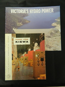 Kiewa Valley Historical Society
Booklets - Kiewa Hydro Electric Scheme, 1. "Power From Kiewa" and 2. "Victoria's Hydro Power", 1. Made in July 1968 and 2. Made in Aug. 1985
1. The State Electricity Commission of Victoria built the Kiewa Hydro Electric Scheme from the 1930's to the 1960's. This booklet was to inform visitors and to promote tourism. 2. The State Electricity Commission built several hydro power stations from 1928 - 1981. This booklet names each with a summary and explanation.The State Electricity Commission of Victoria built the Kiewa Hydro Electric Scheme establishing infrastructure such as the Bogong and Mt Beauty townships and the opportunity for tourism in the area.1. Colored soft cover with photo of McKay Creek Power Station on the front and Mt Beauty township on the back. Published by the SECV 2. Colored soft cover with Rocky Valley Dam on the front and inserted photo of a stream and snow on the back. Published by the SEC.state electricity commission of victoria; kiewa hydro electric scheme; victoria's hydro electric power; kiewa; mckay creek power station; clover power station; west kiewa power station -
 Bendigo Historical Society Inc.
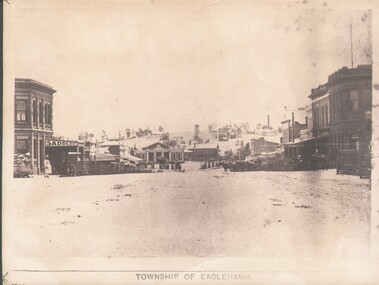
Photograph - WES HARRY COLLECTION: TOWNSHIP OF EAGLEHAWK, C. 1860's
Sepia photograph of the Township of Eaglehawk, looking down the hill from about Victoria St. Visible are the Victoria Hotel and the Exchange Hotel on the left hand side of the photo. At the bottom of the hill there is the old Town Hall and in the distance on the hill is one of the Virginia Reef mines.place, eaglehawk, streetscape, eaglehawk, victoria hotel, exchange hotel, virginia reef -
 Bendigo Historical Society Inc.
Map - REDESDALE, See above
Map: two maps on either side of backing, (1) Township of Redesdale, Parish of Redesdale. (2) Surban lands, Parish of Spring Plains, County of Dalhousie. Date are 26th May 1873 and 12/07/1909 ( number 157 in Map Cupboard 1)map, dalhousie, township, redesdale, parish of spring plains, county of dalhousie -
Tatura Irrigation & Wartime Camps Museum
Book, Girgarre Living History, Girgarre. Girgarre Living History, 2016
Girgarre - an extraordinary history, closer settlement, soldier settlement and family stories.Tells of the history of Girgarre, with information obtained from a collection of stories and extensive research into the Closer and Soldier Settlement of the districtRectangular shaped book ,aerial photo of the township and environs of Girgarre, on Market Day, September 2013. Photo extends over front & back covers, highly colourful cover. 251 pages. B/W photos and maps of local families and local scenes.girgarre, family histories, soldier settlement -
Tatura Irrigation & Wartime Camps Museum
Book, Girgarre Living History, Girgarre. Girgarre Living History, 2016
Girgarre - an extraordinary history, closer settlement, soldier settlement and family stories.Tells of the history of Girgarre, with information obtained from a collection of stories and extensive research into the Closer and Soldier Settlement of the districtRectangular shaped book ,aerial photo of the township and environs of Girgarre,on Market Day, September 2013. Photo extends over front & back covers, highly colourful cover. 251 pages ,B/W photos and maps of local families and local scenes.girgarre, family histories -
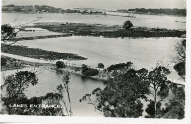
 Lakes Entrance Regional Historical Society (operating as Lakes Entrance History Centre & Museum)
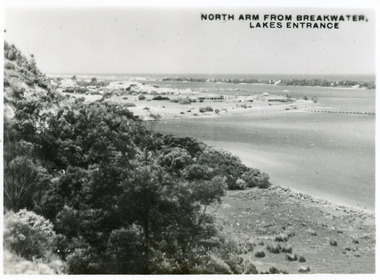
Postcard, 1945c
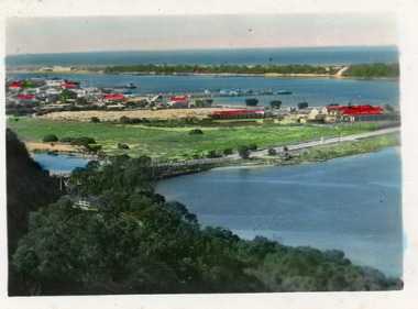
One other copy same sizeBlack and white small format postcard of the entry to the North Arm, taken from Jemmys Point. It shows a steep cliffside above the calm waters, township of Lakes Entrance and Cunninghame Arm, and sand hummocks of southern shore in distance. Lakes Entrance VictoriaNorth Arm from Breakwater - Lakes Entrancetownship, waterways, topography -
 Lakes Entrance Regional Historical Society (operating as Lakes Entrance History Centre & Museum)
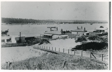
Photograph, 1900c
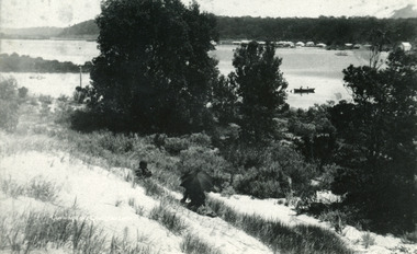
Also four other black and white copies, one size 12 x 18 cm, two size 9 x 14 cm, and one size 10 x 15 cm, one of which was purchased from Helen ClothierBlack and white photograph showing buildings on dunes, and township of Lakes Entrance across lake, Cunninghame Arm. Buildings from left are school, harbour masters house, harbour engineer's house. Boardwalk in foreground. Kalimna Hill in background. Lakes Entrance Victoriawaterways, vegetation, topography, township -
 Lakes Entrance Regional Historical Society (operating as Lakes Entrance History Centre & Museum)
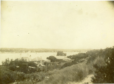
Photograph, Phillips, Miss L, 1900c
Also other black and white copy 9 x 14 cm, donated by Russell Goff with inscription The TownSepia photograph showing view from the dunes across lake, and Cunninghame Arm, to township. Foreground shows dense vegetation on dunes behind two houses, harbour engineer's house on left and contractor John Carpenter's house on right. Lakes Entrance Victoriawaterways, township, boats and boating, topography -
 Bendigo Historical Society Inc.
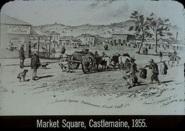
Slide - DIGGERS & MINING. GOLD, c1855
Diggers & Mining. Gold. Market Square Castlemaine, Forest Creek. James J Bundell & Co, Melbourne 1855. Shows the small township, people wagons, dogs. Market Square Castlemaine, 1855. Markings: 26 994.GOL. Used as a teaching aid.hanimounteducation, tertiary, goldfields -
 Bendigo Historical Society Inc.
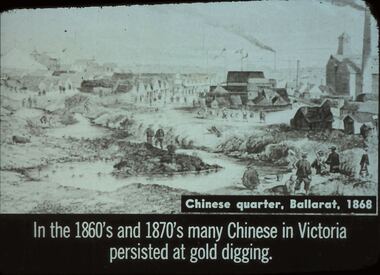
Slide - DIGGERS & MINING. THE CHINESE ON THE GOLD FIELDS, c1868
Diggers & Mining. The Chinese on the Gold Fields. Slide: Chinese quarter, Ballarat, 1868. In the 1860s and 1870s many Chinese in Victoria persisted at gold digging. Slide shows township and Chinese along the creek looking for gold. Markings: 13. Used as a teaching aid.hanimounteducation, tertiary, goldfields -
 Lakes Entrance Regional Historical Society (operating as Lakes Entrance History Centre & Museum)
Postcard - Township, 1998c
Tinted small format postcard showing the township situated on the isthmus between two stretches of water the Cunninghame Arm and the North Arm. Work in progress widening the North Arm Bridge as seen by workmen's huts beside the southern approach. Lakes Entrance Victoriajetties, waterways, topography, township -
 Lakes Entrance Regional Historical Society (operating as Lakes Entrance History Centre & Museum)
Photograph - Township, 1910c
One other copyBlack and white photograph of the township, taken from the hummocks. It shows a person sitting under a black umbrella on a sand hill in the foreground, Cunninghame Arm, two persons in rowboat on water, buildings along Esplanade, Kalimna Heights in background. Lakes Entrance Victoriatopography, waterways -
 Lakes Entrance Regional Historical Society (operating as Lakes Entrance History Centre & Museum)
Postcard - Bullock Island, 1920c
1 x Faded miniature postcard 6.5 x 8.5|1 x Black and white 9.5 x 12 copied from album in private hands|1 x Sepia toned 10 x 15|1 x Black and white 12 x 17.5Black and white small format postcard of Bullock Island. It shows the approaches to the concrete North Arm Bridge over North Arm, the footbridge to Bullock Island, the entrance to the Gippsland Lakes from Bass Strait and part of the township on the hummocks. Lakes Entrance VictoriaLakes Entrancewaterways, topography, islands, bridges -
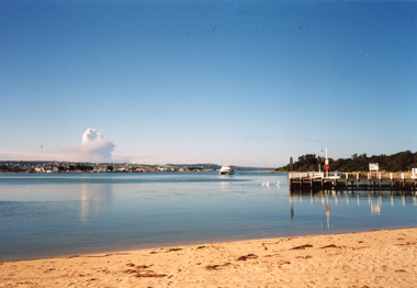 Lakes Entrance Regional Historical Society (operating as Lakes Entrance History Centre & Museum)
Photograph - Thunderbird, Holding M, 2000c
Colour photograph of the township viewed from the southern shore of Cunninghame Arm at the New Works. New Works Jetty in mid foreground, tourist launch Thunderbird on lake. Smoke from a bushfire in distance. Reflections in calm waters of lake. Lakes Entrance Victoria tourism, waterways, township, boats and boating -
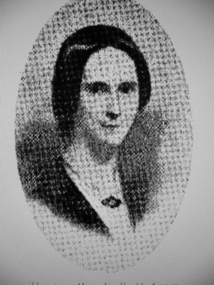 Greensborough Historical Society
Photograph - Digital image, Mrs Edward Green, 1850c
Portrait of Mrs Edward Green. In the 1840s, Edward B. Green ran the mail service between Melbourne and Sydney and owned a parcel of land on the Plenty River. He engaged a surveyor to draw up plans and lay out a township on the slopes overlooking the river, and to mark out small farm holdings on the flats. This small township named after him is now Greensborough.Digital copy of portraitedward bernard green -
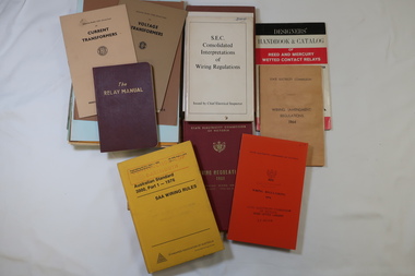 Kiewa Valley Historical Society
Books - SECV Text Books x19, Voltage Transformers and Wiring Regulations
The SECV constructed the Kiewa Hydro Electric Scheme including the township of Mt Beauty. Text books were available for the workers.The books were used by the workers on the Kiewa Hydro Electric Scheme.Variety of text books some published by the SECV on the topics - 'Voltage Transformers' and 'Wiring Regulations'secv, voltage transformers, wiring regulations -
 Eltham District Historical Society Inc
Photograph, View at Hurstbridge, 1924
View of Hurstbridge township overlooking fruit trees in flower in the foregaround and ploughed paddocks ready for crop planting in the middle of the photo.This photo forms part of a collection of photographs gathered by the Shire of Eltham for their centenary project book, "Pioneers and Painters: 100 years of the Shire of Eltham" by Alan Marshall (1971). The collection of over 500 images is held in partnership between Eltham District Historical Society and Yarra Plenty Regional Library (Eltham Library) and is now formally known as The Shire of Eltham Pioneers Photograph Collection.' It is significant in being the first community sourced collection representing the places and people of the Shire's first one hundred years.Digital imagesepp, shire of eltham pioneers photograph collection, hurstbridge, orchard, fruit trees -
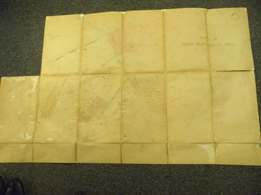 Yarra Glen & District Historical Society
Map, Plan of Yarra Glen Water Area
The map has been used by water supply officers to map the supply of water to properties in the township area of Yarra Glen.The item is significant because it records changes to the supply of water to Yarra Glen over a period of approximately 100 years. It also records property owners and subdivisions.Flat map which folds into 12 pages with a dark red cloth cover. One page in top left corner is missing. Scale of the map is 300 feet to an inch. Cream coloured packing tape has been placed along the back of the folds and is now peeling off.Round stamp in top right corner "Shire of Eltham". Pencil note on top left existing page "Note - includes record of 8 LP's subdivisions. HC". Information has been added to the map over an extended period of time in red ink, black pencil, blue pencil and blue biro.yarra glen/water supply/ -
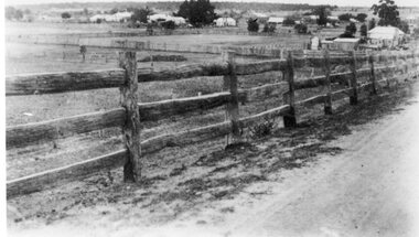
 Stawell Historical Society Inc
Photograph, Stawell Township looking towards Sister Rocks which includes Stawell East School 1880 -- later becoming Stawell High School
Stawell Township - includes Stawell East School 1880. Later Stawell High School. Looking towards Sister Rocks.stawell -
 Clunes Museum
photograph, KODAK PRINT
VIEW OF GRAVEL ROAD FROM CLUNES TOWNSHIP TO STATION FLAT. LOWER PART OF PORT PHILLIP MINE ON LEFT OF PHOTO.VIEW OF ROAD LEADING TO STATION FLAT CLUNES. ANGLICAN CHURCH ON HILL IN BACKGROUND.local history, photography, photographs, clunes landscape. -
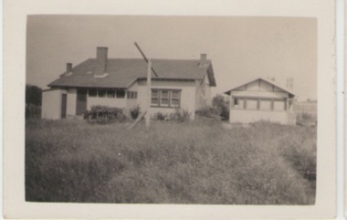 Sunbury Family History and Heritage Society Inc.
Photograph, c1920s - 1930s
In the 1920s a few Californian style homes were built in the township of Sunbury and some of them can still be seen in the town.A black and white photograph of the rear view of a weatherboard Californian style bungalow built in an open paddock. The house also has a smaller building on the RHS and an outdoor toilet as well as a double clothes line are in the yard. sunbury township. -
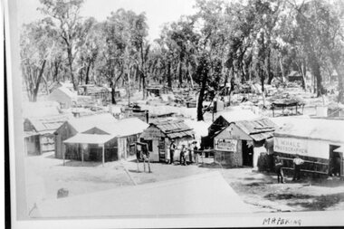 Stawell Historical Society Inc
Photograph, Mafeking Goldfield at Mt William with Photographer, Hairdresser and other buildings c1900
Mafeking Goldfield Mt William Mining Scene c1900. Businesses in township. W Hale Photographer. Hairdresser and other buildings. stawell -
 Stawell Historical Society Inc
Photograph, Great Western Township looking North from Paxton Street c1890's
Great Western Township c1890's looking North from Paxton Street. Original Hotel. Store. Salinger's and Cottages.stawell -
Glenelg Shire Council Cultural Collection
Souvenir - Souvenir Envelope, 1984
Two Australia Post souvenir envelopes - Victoria's 150th anniversary (Portland. First settlement). Cream coloured, envelope, full colour design on front of envelope shows Edward Henty, view of township, thistle, pier and council logos. Reverse has shows 150th.australia post, souvenir, victoria 150th -
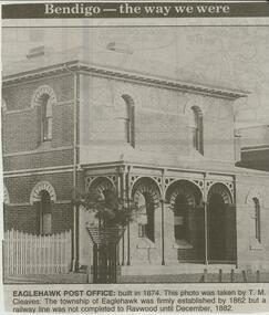 Bendigo Historical Society Inc.
Newspaper - JENNY FOLEY COLLECTION: EAGLEHAWK POST OFFICE
Bendigo Advertiser ''The way we were'' from 2000. Eaglehawk post office: built in 1874. This photo was taken by T. M. Cleaves. The township of Eaglehawk was firmly established by 1862 but a railway line was not completed was not completed to Raywood until December, 1882. The clip is in a folder.newspaper, bendigo advertiser, the way we were -
 Bendigo Historical Society Inc.
Slide - DIGGERS & MINING. DIGGERS AND MINERS, 1850s
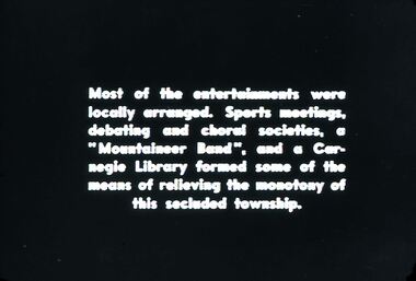
Diggers & Mining. Diggers and Miners. Most of the entertainments were locally arranged. Sports meetings, debating and choral societies, a 'Mountaineer Band', and a Carneigie library formed some of the means of relieving the monotony of this secluded township. Markings: 50 994.5 WAL. Used as a teaching aid.hanimounteducation, tertiary, goldfields -
Bendigo Historical Society Inc.
Map - HUNTLY : COUNTY OF BENDIGO, August 1954
Map. Huntly, County of Bendigo. Whirrakee, Bagshot, Wellsford, Nerring, Neilborough, Township of Huntly. Drawn and reproduced at the Department of Lands and Survey, Melbourne, Victoria. August 1954. Price 2/-. By authority W.M. Houston, Government Printer. (number 42 in map cupboard 1)W.M. Houston, Govt. Printer.map, bendigo, huntly