Showing 9356 items matching "warrandyte"
-
 Warrandyte Diary
Newspaper - Periodicals, Monthly, Cliff Green, Warrandyte Diary, 1/06/2013
News and features relevant to the community of WarrandyteCommunity Newspaper printed on newsprint in black and white (with some colour pages)non-fictionNews and features relevant to the community of Warrandyte -
Warrandyte Diary
Newspaper - Periodicals, Monthly, Cliff Green, Warrandyte Diary, 1/07/2013
News and features relevant to the community of WarrandyteCommunity Newspaper printed on newsprint in black and white (with some colour pages)non-fictionNews and features relevant to the community of Warrandyte -
Warrandyte Diary
Newspaper - Periodicals, Monthly, Cliff Green, Warrandyte Diary, 1/08/2013
News and features relevant to the community of WarrandyteCommunity Newspaper printed on newsprint in black and white (with some colour pages)non-fictionNews and features relevant to the community of Warrandyte -
Warrandyte Diary
Newspaper - Periodicals, Monthly, Cliff Green, Warrandyte Diary, 1/09/2013
News and features relevant to the community of WarrandyteCommunity Newspaper printed on newsprint in black and white (with some colour pages)non-fictionNews and features relevant to the community of Warrandyte -
Warrandyte Diary
Newspaper - Periodicals, Monthly, Scott Podmore, Warrandyte Diary, 1/10/2013
News and features relevant to the community of WarrandyteCommunity Newspaper printed on newsprint in black and white (with some colour pages)non-fictionNews and features relevant to the community of Warrandyte -
Warrandyte Diary
Newspaper - Periodicals, Monthly, Scott Podmore, Warrandyte Diary, 1/11/2013
News and features relevant to the community of WarrandyteCommunity Newspaper printed on newsprint in black and white (with some colour pages)non-fictionNews and features relevant to the community of Warrandyte -
Warrandyte Diary
Newspaper - Periodicals, Monthly, Scott Podmore, Warrandyte Diary, 1/12/2013
News and features relevant to the community of WarrandyteCommunity Newspaper printed on newsprint in black and white (with some colour pages)non-fictionNews and features relevant to the community of Warrandyte -
 Ringwood and District Historical Society
Booklet - Newsletter, Warrandyte Historical Society Inc. - Louis John Michel, Discoverer of the First Payable Gold Field in Victoria, 1979
Letter and article entitled "MICHEL" by Mrs. Evelyn J. Cooke - Article written by his great granddaughter, addressed to Mrs Jo Laurence of the Warrandyte Historical Society. -
 Ringwood and District Historical Society
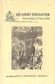
Book, Quarry Disaster - Warrandyte, 27 June 1934 - Written by Bruce Bence (January 1993)
Typewritten pages outlining events around the collapse of the gravel quarry on Bill Hussey's property in Hussey's Lane, South Warrandyte at 8:45am on 27 June, 1934.Includes copy of a photo collation courtesy of LaTrobe Collection, State Library of Victoria, showing Walter Black and William Shea who died in the quarry accident, and Len Carrick who survived the fall. -
 Eltham District Historical Society Inc
Photograph, Fay Bridge, Eastern boundary of former Warrandyte Aboriginal Reserve, North Warrandyte, 7 November 2016
Two bronze commemorative plaques on rocks, unveiled by Wurundjeri Tribe Council Elders, mark two eastern boundaries of the former Warrandyte Aboriginal Reserve on the north and south sides of the Yarra. This project was initiated by Nillumbik Reconciliation Group in close association with Reconciliation Manningham and the Wurundjeri Tribe Council, as a means of commemorating the last great corroboree of the Kulin Nation which was held at Pound Bend in March 1852. This plaque is on the Nillumbuk side of the Yarra, accessed via The Boulevard, North Warrandyte. The plaque is set on a rock approximately 50 metres before the turning circle at the end of The Boulevard. Plaque : Warrandyte Aboriginal Reserve This commemorative rock marks an eastern boundary of the former Warrandyte Aboriginal Reserve established in 1852. Centred on Pound Bend, it covered 1,908 acres on both sides of the Yarra River (Birrarung). That same year saw the last great gathering of the Kulin nation here in Wurundjeri country which was celebrated over two weeks with traditional performance and games. For a few years longer the reserve intermittently served as a ration station.With gold having been discovered at Warrandyte, the Wurundjeri were moved on again but ultimately secured a permanent home at Coranderrk, Healesville. A second commemorative plaque and rock is located on the opposite bank of the Yarra and its confluence with Stony Creek. Melway ref : 23 C 9 Unveiled by Wurundjeri Elder, Uncle Bill Nicholson on 23rd March 2013 Funded by the Robert Bridgford Indigenous Trust (Nillumbik Community Fund) with assistance from Manningham City Council Small Grants Program Ref: Monument Autralia https://monumentaustralia.org.au/themes/culture/indigenous/display/99680-warrandyte-aboriginal-reserve-fay bridge collection, 2016-11-07, aboriginal reserve, north warrandyte, plaques, warrandyte aboriginal reserve -
 Ringwood and District Historical Society
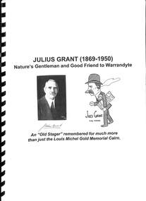
Book, Julius Grant (1869-1950) Nature's Gentleman and Good Friend to Warrandyte
Bound compilation of notes about Julius Grant, Park Orchards orchardist, and his involvement with the Warrandyte community, Shire of Doncaster and Templestowe as Councillor, and participant in a Cairn Committee for erection of memorial at Anderson's Creek in Warrandyte marking Louis J. Michel and party rewarded by Government as discoverers of first goldfield in Victoria. Also includes substantial coverage of Grant's theatrical involvement, Australian films, and Adam Lindsay Gordon Memorial Committee. "An Old Stager remembered for much more than just the Louis Michel Gold Memorial Cairn." -
 Ringwood and District Historical Society
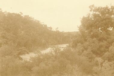
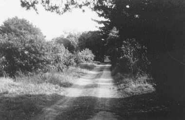
Photograph/Postcard, Yarra at Warrandyte. (undated)
Written on back of Postcard photograph, "Yarra at Warrandyte". undated -
 Ringwood and District Historical Society
Photograph, Warrandyte Rd. bridge, Ringwood. Sept. 1987
Written on back of photograph, "13.9.87. Warrandyte Rd. bridge". -
 Ringwood and District Historical Society
Photograph, Warrandyte Rd. bridge, Ringwood. April 1987
Written on back of photograph, "8.4.87. Warrandyte Rd. bridge". -
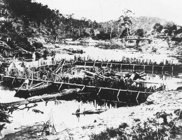 Ringwood and District Historical Society
Photograph, Warrandyte flooded coffer dam(undated)
Catalogue card reads, "Warrandyte flooded coffer dam" -
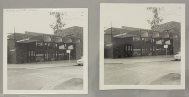
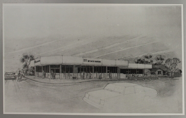 Ringwood and District Historical Society
Photograph, State Bank Artist's Impression, Warrandyte Road, Ringwood North
Artist's Impression of the new Ringwood North State Bank premises, circa 1980At the corner of Dickson's Crescent and Warrandyte Road, Ringwood North -
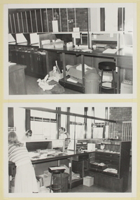 Ringwood and District Historical Society
Photograph, Interior view of Ringwood North State Bank , north-east corner of Dickson's Crescent and Warrandyte Road
Interior view of the new Ringwood North State Bank premises on the north-east corner of Dickson's Crescent. Exterior view. Unknown date. Opened 25 October 1971At the corner of Dickson's Crescent and Warrandyte Road, Ringwood North. -
 Ringwood and District Historical Society
Photograph, Ringwood North State Bank , north-east corner of Dickson's Crescent and Warrandyte Road
The new Ringwood North State Bank premises on the north-east corner of Dickson's Crescent. Exterior view. Unknown date.At the corner of Dickson's Cresent and Warrandyte Road, Ringwood North. -
 Ringwood and District Historical Society
Map, Plan of the Parish of Warrandyte County of Evelyn - 1841
Blueprint copy of Survey Map W27 detailing original Selectors' names and property locations between Yarra Yarra River (Warrandyte) and Mullum Mullum Creek (Ringwood). List of Parish map references including property bearings, distances in Links, and markings on trees. Pound Bend area of Warrandyte marked as Reserve For Aborigines. Descriptive remarks include areas marked "scrubby, flat, sandy soil". Several other references faded and illegible.(Map) by T.H. Nutt Feb 3 1841. -
 Eltham District Historical Society Inc
Photograph, Fay Bridge, Ruins of the old Warrandyte Battery, 7 November 2016
Remains of the timber foundation of the State Battery, built here in 1897 can be seen on the banks of the Yarra River just east of the Warrandyte Bridge on the Warrandyte side of the river. The Battery was driven by waterwheel and was used to crush ore from the Warrandyte Goldfields.fay bridge collection, 2016-11-07, warrandyte battery, ruins -
 Eltham District Historical Society Inc
Photograph, Yarra River at Warrandyte, 1990, 1990
Originally contained in a 'magnetic' photo album believed to have been donated by Mr Eric Stephenson, Jingalong, 110 Ryans Road, Eltham, Vic. 3095; relocated to archival safe storage.Two colour photographswarrandyte, yarra river -
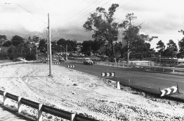
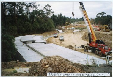 Ringwood and District Historical Society
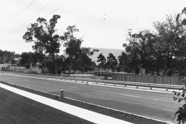
photograph, Eastlink Ringwood Bypass Construction-Bypass from Warrandyte Rd 17/5/95
Colour photographWritten on back of photo: "Ringwood Bypass-From Warrandyte Rd -
 Ringwood and District Historical Society
Photograph, Entrance to Godbehear's orchard, Warrandyte Rd, Ringwood. (Undated)
Written next to photograph, "Entrance to Godbehear's orchard, Warrandyte Rd. -
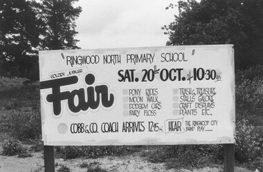 Ringwood and District Historical Society
Photograph, Ringwood North Primary School Fair - Sign at corner Oban and Warrandyte Roads, North Ringwood. (undated, but possibly 1984)
Golden Jubilee Fair sign. Sat 20th Oct. No year, but most likely year with this date is 1984, when a number of photos in this area were taken by RDHS.Written on back of photograph, "Sign at corner Oban and Warrandyte Roads". -
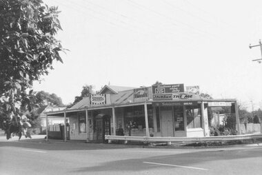 Ringwood and District Historical Society
Photograph, Store, corner Warrandyte and Loughnan Roads (undated)
Typed below photograph, "Store, corner Warrandyte and Loughnan Roads". -
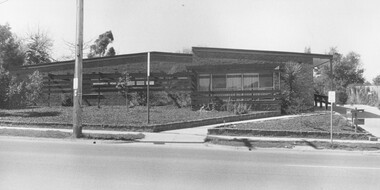 Ringwood and District Historical Society
Photograph, 44 Warrandyte Rd. Clinic, 1973
Written on backing sheet, "44 Warrandyte Rd. Clinic, 1973". -
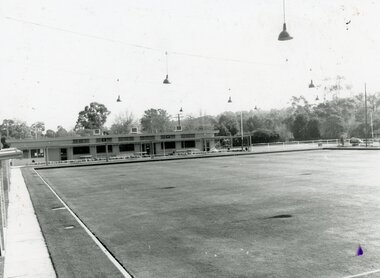 Ringwood and District Historical Society
Photograph, Ringwood Bowls Club - Warrandyte Road, 1991
Black and white photograph"On front of photograph" Ringwood Bowling Club Warrandyte Road, 1991 -
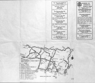 Melbourne Tram Museum
Ephemera - Timetable, Melbourne & Metropolitan Tramways Board (MMTB), Warrandyte - Templestowe - East Doncaster - Box Hill - Melbourne services, Mar. 1962
Bus Timetable - 8 sections - folded sheet with map of bus services, timetables, sections, fares, route numbers for Warrandyte - Templestowe - East Doncaster - Box Hill - Melbourne services. 2 copies held.trams, tramways, timetables, tickets, fares, mmtb, buses -
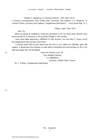 Eltham District Historical Society Inc
Folder, Warrandyte Bridge, 1999
Printouts marked "M Houghton" (Murray Houghton was a local historian from Warrandyte Historical Society) headed "literature search - second Warrandyte bridge" with transcriptions from outward correspondence letter book files from Eltham Shire Secretary and Engineer C.S. Wingrove to various parties 1874 - 1879 which relate to the bridge at Warrandyte. 11 pagesHG Booklet 21batt, batt's hotel, brock, c.s. wingrove, christmas hills, eltham shire council, harry gilham collection, kilpatrick, road construction, victoria hall, war memorial, warrandyte bridge, wingrove, yarra flats, yarra glen -
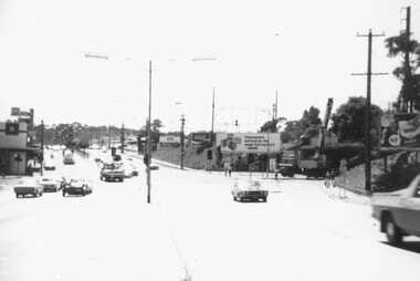 Ringwood and District Historical Society
Photograph, Widening of railway bridge on Warrandyte Rd, Ringwood 1977
Catalogue card reads, "Widening of railway bridge on Warrandyte Rd.". 1977