Showing 13708 items
matching wye-river-bridge
-
 Ballarat Heritage Services
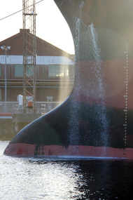
Digital photographs, L.J. Gervasoni, Yarra River Melbourne Docklands ship releases ballast, 2015
Digital Imagesyarra river melbourne docklands, yarra river, dock, docklands, shipping, port, channel, water, ship, ballast -
 Ballarat Heritage Services
Digital photographs, L.J. Gervasoni, Yarra River Melbourne Docklands willamstown yacht club, 2015
Digital Imagesyarra river melbourne docklands, yarra river, dock, docklands, shipping, port, channel, water, ship, yachts, williamstown -
 Ballarat Heritage Services
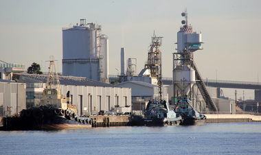
Digital photographs, L.J. Gervasoni, Yarra River Melbourne Docklands tug boats, 2015
Digital Imagesyarra river melbourne docklands, yarra river, dock, docklands, shipping, port, channel, water, ship, tug boats, tugs -
 Ballarat Heritage Services
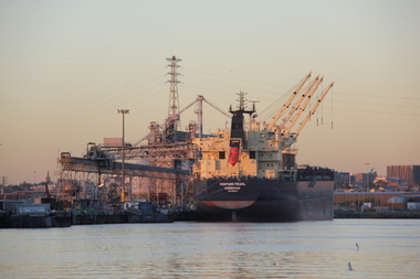
digital photographs, L.J. Gervasoni, Yarra River Melbourne Docklands Venture Pearl, 2015
Digital Imagesyarra river melbourne docklands, yarra river, dock, docklands, shipping, port, channel, water, ship, venture pearl -
 Ballarat Heritage Services
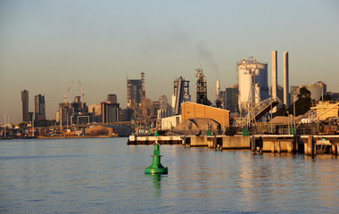
digital photographs, L.J. Gervasoni, Yarra River Melbourne Docklands wharves and markers, 2015
Digital Imagesyarra river melbourne docklands, yarra river, dock, docklands, shipping, port, channel, water, ship, wharf, channel marker -
 Ballarat Heritage Services
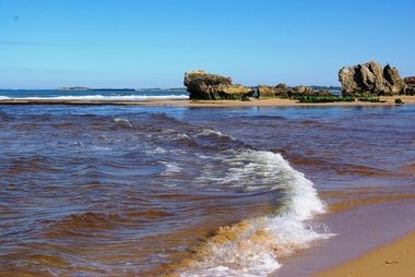
Digital photographs, L.J. Gervasoni, Hopkins River Mouth blocked, c2010 - 2017
hopkins river, mouth, point ritchie, bluehole, warrnambool, coast, coastal, beach, seascape, blocked -
 Ballarat Heritage Services
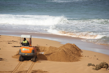
Digital photographs, L.J. Gervasoni, Hopkins River Mouth blocked - artificial channel - sand falling in, c2010 - 2017
hopkins river, mouth, point ritchie, bluehole, warrnambool, coast, coastal, beach, seascape, blocked, digger, opening mouth, mechanical opening -
 Ballarat Heritage Services
Digital photographs, L.J. Gervasoni, Hopkins River Mouth reef exposed after flood, c2010 - 2017
hopkins river, mouth, point ritchie, bluehole, warrnambool, coast, coastal, beach, seascape, flood, post flood, reef, exposed, geology, coastal geomorphology -
 Ballarat Heritage Services
Digital photographs, L.J. Gervasoni, Hopkins River Mouth in flood - waters receeding, c2010 - 2017
hopkins river, mouth, point ritchie, bluehole, warrnambool, coast, coastal, beach, seascape, flood, post flood, geology, coastal geomorphology, waters receeding -
 Ballarat Heritage Services
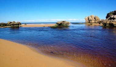
Digital photographs, L.J. Gervasoni, Hopkins River Mouth after the flood, c2010 - 2017
hopkins river, mouth, point ritchie, bluehole, warrnambool, coast, coastal, beach, seascape, flood, post flood, geology, coastal geomorphology, waters receeding -
 Ballarat Heritage Services
Digital photographs, L.J. Gervasoni, Hopkins River Mouth - double channel post flood, c2010 - 2017
hopkins river, mouth, point ritchie, bluehole, warrnambool, coast, coastal, beach, seascape, coastal geomorphology -
 Ballarat Heritage Services
Digital photographs, L.J. Gervasoni, Hopkins River Mouth - blocked - mechanical digger, c2010 - 2017
hopkins river, mouth, point ritchie, bluehole, warrnambool, coast, coastal, beach, seascape, coastal geomorphology -
 Port Fairy Historical Society Museum and Archives
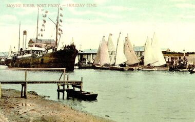
Postcard, Moyne river Port Fairy-holiday time
S.s.Casino crowded with tourists returning after sailing around the bay during Terang Day. The couta boats in full sail possibly did the same thing Hand-coloured photograph of ship and wharfship, boat, sea, river, s.s.casino, couta boats, moyne -
 Greensborough Historical Society
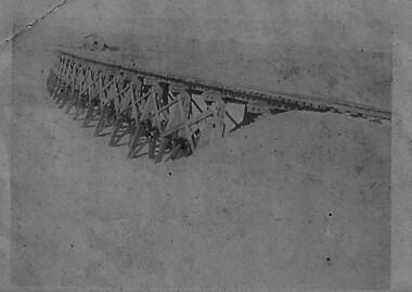
Photograph - Digital image, Charles Marshall et al, Railway bridge at Tel-el-Fara, 1917_
This photograph shows a railway bridge in Tel-el-Fara, PalestineDigital copy of black and white photograph. "Railway bridge over Waddi buzzetti [?] Tel-el Fara"charles marshall, world war 1 -
 Whitehorse Historical Society Inc.
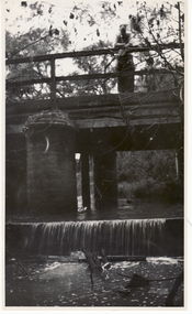
Photograph, Lake Road Bridge Blackburn, 1962
The old bridge demolished in 1965. Photo shows John Henster and daughter standing , looking over the side.Black and white photo of bridge, Lake Road, Blackburnlake road blackburn, lake road bridge blackburn -
 Stawell Historical Society Inc
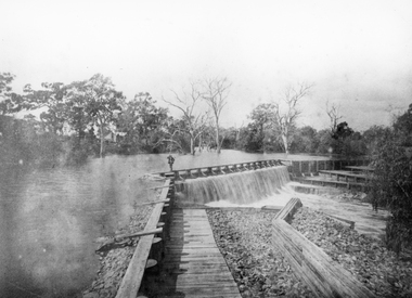
Photograph, Wimmera River Weir at Glenorchy
Wimmera River Weir Glenorchy. Part of Wimmera Mallee Irrigation SystemBlack & white photograph of a weir across a river. Construction of weir is log & wood with a person walking along the weir. Trees in the background.Reproduction Rights Reserved Copied by State Library of Victoriawater -
 Charlton Golden Grains Museum Inc
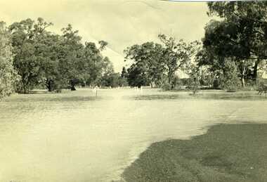
Photograph, Charlton Tribune, 1973 flood at low water bridge
1973 Flood at Charlton, Vic. At the low water bridge.Unframed photograph/ sepia of 1973 flooding of Charlton at low water bridge.flood, low water bridge -
 Hume City Civic Collection
Book, Saltwater River History Trails
This book which was printed in 1984 gives not only the geology of the area but also the history of the various areas that Jacksons Creek and the Saltwater River now known as the Maribyrnong River pass through. There are many drawings and photos accompanying the information relating to the various areas and buildings researched in this book. From Sunbury to Williamstown some of the names and places mentioned include John Aitken, George Evans, William J.T. Clarke, Ben Eadie, Rupertswood, Goonawarra Vineyard, Organ Pipes, Glenara, Walter Clark, Keilor, Overnewton, Avondale Heights, Solomons ford, Riverview Tea Gardens, Anglers Hotel, Aberfeldie Park, Humes Pipe Works, Powder Magazine, Maribyrnong, Munitions factories, Footscray Park, Flemington, Footscray, Yarraville, Newport, Williamstown, Commonwealth reserve, the blue stone lighthouse. A small cream/olive green colour covered printed book of 74 pages. The front cover shows part of a pen and wash drawing of a homestead. It has the name of the book and the author Hugh Anderson printed at the top of the cover and Sunbury to the Sea printed at the bottom. There are many drawings and photos included in the book.SALTWATER RIVER/HISTORY TRAILS/HUGH ANDERSON/Sunbury to the Seasaltwater river, maribyrnong river, jacksons creek, anderson hugh, sunbury, keilor, organ pipes national park, solomons ford, riverview tea gardens, humes pipe works, powder magazine, footscray, yarraville, newport, williamstown -
 Lakes Entrance Historical Society
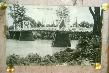
Photograph - Bridges, 1920
First bridge over the Snowy River at Orbost built 1891Black and white photographic print showing early first bridge across Snowy River thick vegetation along river banks. Orbost Victoriabridges, waterways -
 Lakes Entrance Historical Society
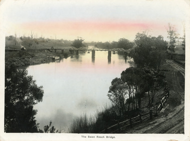
Postcard - Bridges, Bulmer, H D, 1915
Colour tinted large format postcard showing lifting bridge over the Tambo River, at Swan Reach, Victoria. Bridge is closed to allow road traffic through. Rough gravel road to Metung on right. Landing on left near bridge. Vegetation on river bank right. Houses in distance on both sides of river.The Swan Reach Bridgeboats and boating, bridges, waterways -
 Marysville & District Historical Society
Booklet - Information booklet, Ann Thomas, Wilks Creek Bridge, 1993
A history of the Wilks Creek Bridge and its connection to the Yarra Track.Paperback. Front cover has an old photograph of the Wilks Creek Bridge.non-fictionA history of the Wilks Creek Bridge and its connection to the Yarra Track.wilks creek bridge, yarra track, narbethong, marysville, victoria, clement wilks, wood's point goldfields, jordan goldfields, john monash, monash and anderson, 2009 black saturday bushfires -
 Orbost & District Historical Society
plan, before 1948
Drainage infrastructure was developed and maintained in this region by the Snowy River Improvement Trust. The Trust was administered by a local committee and its activities funded by a local rate charged on the farmers and land owners in the Trust’s designated district. The level of the rate charged by the Trust was designed to be proportionate to the benefit derived from the works undertaken. Financial assistance was provided by the State Government from time to time for specific projects such as post flood repairs but not for new capital works. The Trust undertook new drainage and river management works including tree planting, rock beach construction and servicing of the drains and flood gates. The Trust also provided a personal flood warning service to the farmers in its district. The Trust ceased to operate in 1997 with the advent of the East Gippsland Catchment Management Authority. The infrastructure developed by the Trust continues to provide a service to the farmers in the region. (ref. 4 East Gippsland CMA Submission to Inquiry into Flood Mitigation Infrastructure in Victoria) This plan is significant as a historical document. The Snowy River Improvement Trust was vital to the Orbost district because of its ability to apply local knowledge and to engage the local farming community.A large plan of divisions of land for the purpose of levying the Snowy River Improvement District - Bete Bolong, Orbost, Waygara, Newmerella and Orbost East. The properties are coloured according to levy amount. The scale is 1" - 20 chains. snowy-river-improvement-trust -
 Clunes Museum
Photograph, C. NETTLETON, GOVERNMENT BRIDGE, CLUNES, SOUTH WEST
PHOTOGRAPH, - VIEW TAKEN FROM GEORGE STREET SHOWING LANDSCAPE, GOVERNMENT BRIDGE - LOOKING SOUTH WEST. .1 SEPIA PHOTOGRAPH MOUNTED ON CARDBOARD .2 SEPIA PHOTO PRINT .3 BLACK AND WHITE PHOTO PRINT .4 SMALL BLACK AND WHITE PHOTO PRINT .5 SMALL BLACK AND WHITE PHOTO PRINT GOVERNMENT BRIDGE CLUNES. SOUTH WESTlocal history, photography, photographs, bridges and buildings -
 Ringwood and District Historical Society
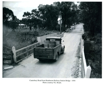
Photographs / Album Pages, Canterbury Road from Heathmont Railway Station Bridge 1954, 1954
Houghton & Byrne Pest Service Truck on Canterbury Road crossing Heathmont Railway Station Bridge 1954. Photo courtesy Vic. RoadsCanterbury Road from Heathmont Railway Station Bridge - 1954. Photo courtesy Vic. Roads -
 Lakes Entrance Historical Society
Postcard - Brodribb River Bridge, Sherwood, Orbost, 1907 c
Black and white postcard of the bridge over the Brodribb River near Orbost VictoriaBrodribb River 6.4.07waterways, bridges, topography -
 Orbost & District Historical Society
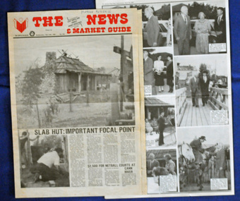
newspaper clippings, April, May 1987
The Slab Hut (Orbost Visitor Information Centre) was opened on March 28, 1987. It was officially opened by Dr D. Caughey, the governor of Victoria. The Orbost Visitor Information Centre is situated in Forest Park on Nicholson Street. The centre is housed in the historic Slab Hut. The hut was an original family dwelling built in 1872, on a site approximately three kilometres upstream from the junction of the Buchan and Snowy Rivers. The Hut was removed from its original site around 1970, and stored until 1984 when the Shire Council approved the current site. It was restored and brought to life as a Tourist Information Centre in 1987.The Slab Hut is an icon of Orbost. These newspaper articles are contemporary records of the opening of this building.A selection of articles from The News and the Snowy River Mail. All relate to the opening of the Slab Hut, the Orbost Visitor Information Centre. They are photographs, information and the history of the Slab Hut.slab-hut-orbost newspaper-snowy-river-mail -
 Orbost & District Historical Society
postcard, C1920-1940
This photograph shows the second major bridge across the Snowy River at Orbost. The current Snowy River bridge is the fourth to provide a crossing to the township of Orbost. The first, in 1891, lasted just two years before it succumbed to flood waters. The bridge in this photograph was built in the 1920s as a road and rail bridge, and was again partly washed away by flood waters in 1934. After the end of the first World War the Victorian Railways considered an extension of the railhead across the river at Orbost, and in 1922 a new timber and steel girder structure, a joint Country Roads Board — Victorian Railways venture, was built and completed at a cost of £41,000 (the steel girders came from the Flinders Street viaduct reconstruction). Subsequently it was decided not to take the railway across the river, and the bridge was only used by road traffic. It was severely battered by floods during its life. and after the 1971 floods was eventually replaced by the current bridge in 1975. (info from Newletter 54N by John Phillips) This item is an early pictorial record of the previous Snowy River bridge at Orbost.A postcard with a black / white photograph of a bridge - timber and steel girder structure - across the Snowy River at Orbost, Reflections of the bridge are seen in the water.snowy-river-bridge-orbost -
Marysville & District Historical Society
Document (Item) - Transcription of a newspaper article, New Bridge Named After Former Shire Councillor, 1965
A transcription of a newspaper article of the naming of the F.J. Barton Bridge in Marysville in Victoria.A transcription of a newspaper article of the naming of the F.J. Barton Bridge in Marysville in Victoria.marysville, victoria, fj barton, steavenson river, healesville shire council, fred barton, thomas barton, fj barton bridge -
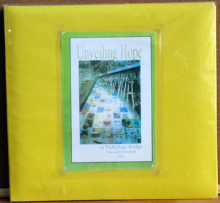 Orbost & District Historical Society
album, Walcott, Judy, Unveiling Hope on McKillops Bridge, 2005
This album was donated to the Orbost & District Historical Society after the death of Judy Walcott, a long-time member. The veiling of McKillops bridge was a 'Year of the Outback' event. The event was organised by Orbost resident, Sr Helen Barnes RSJ. to show solidarity with rural people. The local community transformed the bridge into "a symbol of communal love and hope", when its sides were draped with hundreds of personal messages. McKillop's Bridge, located high in the Snowy Mountains, is named after George McKillop, a pioneering explorer of the area. The bridge is a vital link for isolated farming communities living beyond the Bonang highway.This album is a useful reference tool.A large photo album with a bright yellow cover and 19 plastic sleeves. It contains photographs, newspaper clippings, brochures , maps and an invitation to the veiling of McKillops Bridge on 8th August 2002. It also contains the history of McKillops Bridge.On inside cover - left hand side - "To Marie with Best Wishes from Judy Walcott 8/8/2005"mckillops-bridge album -
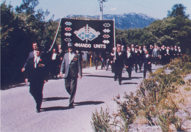 Australian Commando Association - Victoria
Photograph, Inaugural march of M& Z Commando Association members at The Australian Commando Memorial at Tidal River 16 November 1964
The WW2 Commando memorial cairn was unveiled at Tidal River on 15 November 1964 by the Lieutenant Governor of Victoria Lieutenant General Sir Edmund Herring. Former WW2 Commandos march under their Association banner to the cairn for the dedication ceremony.This was the first dedication of a significant WW2 Commando memorial. The Victorian Governor, Lieutenant General Sir Edmund Herring, unveiled the Commemorative Cairn that has become the de facto national Commando memorial.Rectangular colour glossy print photograph of former WW2 Commandos marching at Tidal River.From Don Bergmanww2, world war ii, australian commandos, independent companies, australian commando association, tidal river, wilsons promontory national park