Showing 22698 items
matching yarra
-
 Greensborough Historical Society
Map, Melbourne and Metropolitan Board of Works. Survey Division, MMBW, Yarra 2500 / 11.21. Bundoora, east of Plenty Road, 1979_01
Melbourne and Metropolitan Board of Works. Yarra 2500 [base map] 11-21. Bundoora, east of Plenty Road. Parish of Keelbundoora 2856, Municipalities of Diamond Valley 257, Preston 225 and Whittlesea 239. Prominent streets include: Grimshaw Street, Settlement Road and Plenty Road. Includes Yulong Park.MMBW Map in 1:2500 [scale] series. Cream parchment with green tape reinforcing on edges and punched holes on left edge.mmbw, melbourne and metropolitan board of works, shire of diamond valley, bundoora - maps -
 Greensborough Historical Society
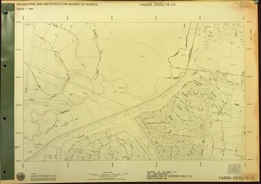
Map, Melbourne and Metropolitan Board of Works. Survey Division, MMBW, Yarra 2500 / 16.24. Northern Diamond Creek and Wattle Glen, 1978_02
Melbourne and Metropolitan Board of Works. Yarra 2500 [base map] 16-24. Northern Diamond Creek and Wattle Glen. Parishes of Nillumbik 3310 and Greensborough 2724. Municipalities of Diamond Valley 257 and Eltham 238. Prominent streets include: Hurstbridge Road, and Reynolds Road. Includes Wattle Glen Station.MMBW Map in 1:2500 [scale] series. Cream parchment with green tape reinforcing on edges and punched holes on left edge.mmbw, melbourne and metropolitan board of works, shire of diamond valley, wattle glen - maps, diamond creek - maps -
 Greensborough Historical Society
Map, Melbourne and Metropolitan Board of Works. Survey Division, MMBW, Yarra 2500 / 13.24. Plenty, Memorial Drive, 1979_03
Melbourne and Metropolitan Board of Works. Yarra 2500 [base map] 13-24. Plenty, Memorial Drive. Parish of Morang 3183. Municipalities of Diamond Valley 257 and Whittlesea 239. Prominent streets include: Oatland Road, River Avenue and Memorial Drive. Includes Plenty River and SEC Transmission easement.MMBW Map in 1:2500 [scale] series. Cream parchment with green tape reinforcing on edges and punched holes on left edge.mmbw, melbourne and metropolitan board of works, shire of diamond valley, plenty - maps -
 Eltham District Historical Society Inc
Photograph, Fay Bridge, Ancient Eel trap on the Yarra River at Laughing Waters, Eltham - pre-dating European settlement, 6 September 2023
Laughing Waters is the name for a stretch of the Yarra Valley Parklands consisting of river flats and hilly riparian bushland. With Birrarung (Yarra River) flowing through, Laughing Waters has been an important gathering place for thousands of years. For the Wurundjeri, ‘Garambi Baan’ (the name for Laughing Waters in Woi wurrung) is an important site for growing and harvesting food. Significantly, Wurundjeri iuk (eel) traps remain at Garambi Baan to this day. The Wurundjeri Woi Wurrung People take their name from the Woi wurrung language word ‘wurun’ meaning the Manna Gum (Eucalyptus viminalis) which is common along ‘Birrarung’ (Yarra River), and ‘djeri’, the grub which is found in or near the tree. Wurundjeri are the ‘Manna Gum People’ and their Ancestors have lived on this land for millennia. The site on the Yarra River near the former Morrison property Killeavey was given a language name in 2015 at the instigation of Wurundjeri Elder, Dave Wandin. Garambi Baan means “laughing waters” in the traditional language, Woi wurrung. The site at Warrandyte was rediscovered by Campbell Beardsell OAM in 2007 and is one of only a few known remaining iuk (eel) traps on Country once found the length of the Birrarung (Yarra) and the Maribyrnong. Original Indigenous aquacultural infrastructure was dismantled, taken away from sites and used to build houses, fords and roads by Europeans. The difficult and restricted access to this site is thought to be one of the reasons for its survival. The iuk trap is located within lands managed by Parks Victoria. The Narrap team in partnership with Parks Victoria and Acacia Land Management have been improving the native vegetation with a program of woody weed removal, exclusion fencing and revegetation. Importantly, the team have restored the trap’s infrastructure and have demonstrated its effectiveness.” References: Wurundjeri Woi Wurrung Cultural Heritage Aboriginal Corporation - Laughing Waters. (2023, September 3). Retrieved from https://inplace.org.au/laughing-waters/ GARAMBI BAAN LAUGHING WATERS RESIDENCY CENTRE 2020 2024 Strategic Plan, Nillumbik Shire Council (2023, September 3). Retrieved from https://www.nillumbik.vic.gov.au/files/assets/public/minutes-and-agendas/2020/09-sep/15-sep-cm/ocm.177-20-attachment-1-laughing-waters-arts-program_1.pdffay bridge collection, eel trap, laughing waters, yarra river, wurundjeri woi wurrung, garambi baan, 2023-09-06 -
 Eltham District Historical Society Inc
Photograph, Fay Bridge, Ancient Eel trap on the Yarra River at Laughing Waters, Eltham - pre-dating European settlement, 16 May 2015
Laughing Waters is the name for a stretch of the Yarra Valley Parklands consisting of river flats and hilly riparian bushland. With Birrarung (Yarra River) flowing through, Laughing Waters has been an important gathering place for thousands of years. For the Wurundjeri, ‘Garambi Baan’ (the name for Laughing Waters in Woi wurrung) is an important site for growing and harvesting food. Significantly, Wurundjeri iuk (eel) traps remain at Garambi Baan to this day. The Wurundjeri Woi Wurrung People take their name from the Woi wurrung language word ‘wurun’ meaning the Manna Gum (Eucalyptus viminalis) which is common along ‘Birrarung’ (Yarra River), and ‘djeri’, the grub which is found in or near the tree. Wurundjeri are the ‘Manna Gum People’ and their Ancestors have lived on this land for millennia. The site on the Yarra River near the former Morrison property Killeavey was given a language name in 2015 at the instigation of Wurundjeri Elder, Dave Wandin. Garambi Baan means “laughing waters” in the traditional language, Woi wurrung. The site at Warrandyte was rediscovered by Campbell Beardsell OAM in 2007 and is one of only a few known remaining iuk (eel) traps on Country once found the length of the Birrarung (Yarra) and the Maribyrnong. Original Indigenous aquacultural infrastructure was dismantled, taken away from sites and used to build houses, fords and roads by Europeans. The difficult and restricted access to this site is thought to be one of the reasons for its survival. The iuk trap is located within lands managed by Parks Victoria. The Narrap team in partnership with Parks Victoria and Acacia Land Management have been improving the native vegetation with a program of woody weed removal, exclusion fencing and revegetation. Importantly, the team have restored the trap’s infrastructure and have demonstrated its effectiveness.” References: Wurundjeri Woi Wurrung Cultural Heritage Aboriginal Corporation - Laughing Waters. (2023, September 3). Retrieved from https://inplace.org.au/laughing-waters/ GARAMBI BAAN LAUGHING WATERS RESIDENCY CENTRE 2020 2024 Strategic Plan, Nillumbik Shire Council (2023, September 3). Retrieved from https://www.nillumbik.vic.gov.au/files/assets/public/minutes-and-agendas/2020/09-sep/15-sep-cm/ocm.177-20-attachment-1-laughing-waters-arts-program_1.pdffay bridge collection, 2015-05-16, eel trap, laughing waters, yarra river, wurundjeri woi wurrung, garambi baan -
 Greensborough Historical Society
Map, Melbourne and Metropolitan Board of Works. Survey Division, MMBW, Yarra 2500 / 13.23. Plenty, Happy Hollow, 1979_03
Melbourne and Metropolitan Board of Works. Yarra 2500 [base map] 13-23. Plenty / Happy Hollow. Parishes of Morang 3183, Nillumbik 3310 and Keelbundora 2856. Municipalities of Diamond Valley 257 and Whittlesea 239. Prominent streets include: McLaughlans Lane and Happy Hollow Drive. Includes Janefield Colony Reserve.MMBW Map in 1:2500 [scale] series. Cream parchment with green tape reinforcing on edges and punched holes on left edge.mmbw, melbourne and metropolitan board of works, shire of diamond valley, plenty - maps, happy hollow -
 Greensborough Historical Society
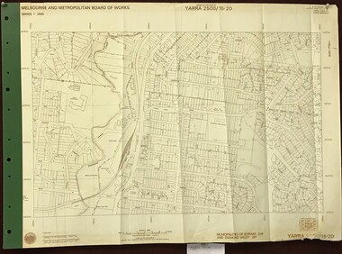
Map, Melbourne and Metropolitan Board of Works. Survey Division, MMBW, Yarra 2500 / 15.20. Eltham, 1977_08
Melbourne and Metropolitan Board of Works. Yarra 2500 [base map] 15.20. Eltham. Municipalities of Diamond Valley 257 and Eltham 238. Prominent streets include: Main Road, Henry Street and Livingstone. Features include the Eltham Station, Catholic Ladies' College, Judge Book Memorial Village and Eltham Central Park.MMBW Map in 1:2500 [scale] series. Cream parchment with green tape reinforcing on edges and punched holes on left edge.mmbw, melbourne and metropolitan board of works, shire of diamond valley, nillumbik, eltham - maps -
 Greensborough Historical Society
Map, Melbourne and Metropolitan Board of Works. Survey Division, MMBW, Yarra 2500 / 13.23. Plenty, Middle Gorge, 1978_04
Melbourne and Metropolitan Board of Works. Yarra 2500 [base map] 13-23. Plenty / Middle Gorge. Parish of Morang 3183. Municipalities of Diamond Valley 257 and Whittlesea 239. Prominent streets include: Gorge Road, Kurrak Road and Browns Lane. Features include the Plenty River and Plenty Gorge Park.MMBW Map in 1:2500 [scale] series. Cream parchment with green tape reinforcing on edges and punched holes on left edge.mmbw, melbourne and metropolitan board of works, shire of diamond valley, plenty - maps, plenty gorge park -
 Yarra Glen & District Historical Society
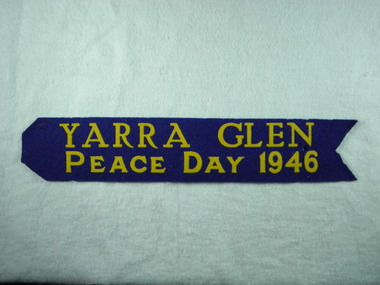
Commemorative banners
Blue felt banner with yellow wording commemorating Yarra Glen Peace Day 1946"YARRA GLEN PEACE DAY 1946" in yellow -
 Greensborough Historical Society
Map, Melbourne and Metropolitan Board of Works. Survey Division, MMBW, Yarra 2500 / 14.27. Yarrambat, Yan Yean Road, 1978_04
Melbourne and Metropolitan Board of Works. Yarra 2500 [base map] 14.26. Yarrambat, Yan Yean Road. Parishes of Morang 3183 and Greensborough 2724. Municipality of Diamond Valley 257. Prominent streets include: Yan Yean Road, North Oatlands Road and Pioneer Road. Features include Yarrambat War Memorial Reserve.MMBW Map in 1:2500 [scale] series. Cream parchment with green tape reinforcing on edges and punched holes on left edge.mmbw, melbourne and metropolitan board of works, shire of diamond valley, whttlesea, yarrambat - maps -
 Melbourne Tram Museum
Book, Yarra Trams, "Building for the next 100 years of Melbourne Trams", 2011
Book - 40 pages - full gloss heavy weight paper, centre stapled titled - "Building for the next 100 years of Melbourne Trams", giving a corporate overview of Yarra Trams - including the partner companies of the KDR partnership, vision, its position in Melbourne's community, its fleet, people, stats, history and future plans. 2nd copy added 15/4/2019.trams, tramways, yarra trams, keolis, kdr, downer, melbourne -
 Melbourne Tram Museum
Pamphlet, Yarra Trams, "Free TramTracker", Apr. 2013
Pamphlet, DL, printed on gloss card, titled "TramTracker" - Yarra Trams real time tram arrival information. Has the TramTRACKER logo (dog) foldout at the top of the card when folded into half. Provides instructions how to use it on the iPhone, Android and other smartphones. and computer systems. Advises passengers where to find the TramTRACKER ID for each stop. .1 - Hangingtrams, tramways, yarra trams, tramtracker, tram stops, operations, computer systems -
 Melbourne Tram Museum
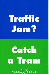
Sign - Adhesive label, Yarra Trams, c2008
Set of four adhesive labels for fitting to the inside of a tramcar advising passengers why travel by tram - each with blue top green bottom with white lettering. All have Yarra Trams logo on the lower edge. .1 - Traffic Jam - Catch a tram .2 - Relax - Tram it! .3 - No parking - Tram it! .4 - Cleaner air? - Tram it! Part of the Tram it campaign.trams, tramways, yarra trams, passengers, signs, tramcars, marketing -
 Melbourne Tram Museum
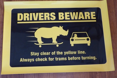
Poster, Yarra Trams, "Drivers Beware", c2012
Set of two full colour poster printed on a vinyl plasticized based sheet - colours yellow and black. .1 - titled "Drivers Beware", staying clear of the yellow line and when turning on roads with trams. Features the rhino on a skateboard. .2 - titled "Beware" - look listen and be alert around trams - has the Yarra Trams logo and website name. Not dated, c2012.trams, tramways, yarra trams, melbourne, public transport, advisory sign, traffic control, safety, rhinos -
 Melbourne Tram Museum
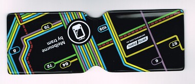
Ephemera - Folder, Yarra Trams, c2014
Packet of two black plastic folders with colour printing indicating Melbourne tram routes for holding a Myki touch card and another card - produced by Yarra Trams c2014. The two folders are contained within a clear plastic bag or packed. 3rd copy added 23-12-2015 from depot holding. See also Reg item 4608 for other examples.trams, tramways, yarra trams, myki, tickets -
 Melbourne Tram Museum
Ephemera - Calendar, Yarra Trams, 2012
Printed A4 calendar on matt paper, full colour providing dates for 2013 including public and school holidays, Australian Open, Grand Prix, Pay weeks and Daylight saving, phone numbers for contacts at each depot, Yarra Trams logo and a symbol for the "Year of the snake". Has an image on the calendar of an E class tram prior to the application of its PTV logos.trams, tramways, yarra trams, calendar -
 Greensborough Historical Society
Map, Melbourne and Metropolitan Board of Works. Survey Division, MMBW, Yarra 2500 / 11.22. Bundoora, 1979_01
Melbourne and Metropolitan Board of Works. Yarra 2500 [base map] 11-22. Bundoora. Parish of Keelbundoora 2856, Municipalities of Diamond Valley 257 and Whittlesea 239. Prominent streets include: Greenhills Road, Cabernet Crescent and Plenty Road. Includes Parade College (Christian Brothers) and "proposed future freeway" (now Metropolitan Ring Road)MMBW Map in 1:2500 [scale] series. Cream parchment with green tape reinforcing on edges and punched holes on left edge.mmbw, melbourne and metropolitan board of works, shire of diamond valley, bundoora - maps -
 Greensborough Historical Society
Map, Melbourne and Metropolitan Board of Works. Survey Division, MMBW, Yarra 2500 / 15.21. Eltham North, 1979_08
Melbourne and Metropolitan Board of Works. Yarra 2500 [base map] 15.21. Eltham North. Parish of Nillumbik 3310. Municipalities of Diamond Valley 257 and Eltham 238. Prominent streets include: Progress Road, Glen Park Road and Zig Zag Road. Features include the Diamond Creek, Eltham Council Pound and Eltham North Reserve.MMBW Map in 1:2500 [scale] series. Cream parchment with green tape reinforcing on edges and punched holes on left edge.mmbw, melbourne and metropolitan board of works, shire of diamond valley, nillumbik, eltham - maps -
 Greensborough Historical Society
Map, Melbourne and Metropolitan Board of Works. Survey Division, MMBW, Yarra 2500 / 14.23. Diamond Creek, Sutherland Homes, 1979_05
Melbourne and Metropolitan Board of Works. Yarra 2500 [base map] 14.23. Diamond Creek, Sutherland Homes. Parish of Morang 3183 and Nillumbik 3310. Municipality of Diamond Valley 257. Prominent streets Aqueduct Road, Diamond Creek Road, Yan Yean Road and McLaughlans Lane. Features include the abandoned Maroondah aqueduct and Sutherland Cottages.MMBW Map in 1:2500 [scale] series. Cream parchment with green tape reinforcing on edges and punched holes on left edge.mmbw, melbourne and metropolitan board of works, shire of diamond valley, plenty - maps, sutherland homes, maroondah aqueduct -
 Greensborough Historical Society
Map, Melbourne and Metropolitan Board of Works. Survey Division, MMBW, Yarra 2500 / 13.28. Mernda, Wilton Vale, 1977_08
Melbourne and Metropolitan Board of Works. Yarra 2500 [base map] 13.28. Mernda, Wilton Vale. Municipality of Diamond Valley 257 and Whittlesea 239. Prominent streets: Wilton Vale Road. Features include Yan Yean Pipe Track and SEC Transmission Lines. The abandoned rail line (old Whittlesea line) is in the top left corner.MMBW Map in 1:2500 [scale] series. Cream parchment with green tape reinforcing on edges and punched holes on left edge.mmbw, melbourne and metropolitan board of works, shire of diamond valley, mernda - maps -
 Greensborough Historical Society
Map, Melbourne and Metropolitan Board of Works. Survey Division, MMBW, Yarra 2500 / 15.24. Diamond Creek, Grassy Flat Road, 1978_02
Melbourne and Metropolitan Board of Works. Yarra 2500 [base map] 15.24. Diamond Creek, Grassy Flat Road. Parish of Nillumbik 3310. Municipality of Diamond Valley 257. Prominent streets include: Everleigh Drive, Broad Gully Road and Clyde Street. Features include the Diamond Creek, Nillumbik Park and Diamond Creek Reservoir.MMBW Map in 1:2500 [scale] series. Cream parchment with green tape reinforcing on edges and punched holes on left edge.mmbw, melbourne and metropolitan board of works, diamond creek - maps, shire of diamond valley -
 Melbourne Tram Museum
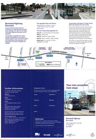
Pamphlet, Yarra Trams, "Your new accessible tram stops", Apr. 2007
Set of five Pamphlets - DL - 3 fold, full gloss paper titled "Your new accessible tram stops" about the introduction in April 2007 of upgrades stops in Burwood Highway - stops 59, 61, 62, and 63 to Superstops. Has VicRoads logos as well as Vic Government and Yarra Trams. Two copies held. 1 -2 fold DL - for stops 124A on routes 96, 109, and 112 - on the Specert St Bridge over the Yarra River - has map. 2 - 3 fold DL for stops 38, 42, 48 and 52 Dandenong Road - Nov. 2007 3 - 3 fold DL for stops 22, 23, 24 and 26 Queens Parade Fitzroy North, Nov. 2008 4 - 3 fold DL for stops 53 to 59 - Matthews Ave Airport West April 2008trams, tramways, yarra trams, burwood, vermont south, superstops, route 75, spencer st, route 96, route 109, route 112 -
 Melbourne Tram Museum
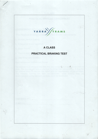
Document, Yarra Trams, "A class Pratical Braking Test", c2005
"A class Pratical Braking Test". Has detailed assessment sheets including the necessary steps, for each form of braking and possible failures. Has the Yarra trams logos at the top of the sheet.Yields information about the assessment for A class tram braking."A class Pratical Braking Test" - 7 A4 sheets stapled in top left hand corner.tramways, training, exams, a class, braking -
 National Wool Museum
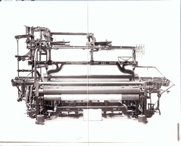
Photograph - Loom, David Sowdon's and Sons, Yarra Falls Mills
Photograph probably for promotional purposes, of a "David Sowden & Sons" loom. Photograph was with other photographs in an envelope printed "David Sowden & Sons" among items from Yarra Falls MillBlack and white photograph showing a loom, 135 is painted on one of the loom cross bars.textile machinery weaving textile mills textile mills, yarra falls mill david sowden & sons, weaving looms, weaving machinery, textile machinery, weaving, textile mills -
 Melbourne Tram Museum
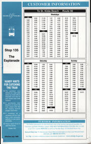
Ephemera - Timetable, Yarra Trams, Stop 135 The Esplanade, July 1999
Timetable dated July 1999, for Stop 135 on The Esplanade - route 96 - Yarra Trams. Has handy hints for catching a tram and where further information could be obtained from.Demonstrates a Yarra Trams timetable for 1999.Laminated sheet with small holes punched into the sheet on the sides.trams, tramways, yarra trams, route 96, the esplanade -
 Melbourne Tram Museum
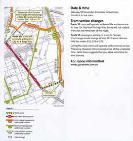
Pamphlet, Public Transport Victoria (PTV), "Route 1 and 6 Buses replace trams", Feb. 2019
Issued for track work in Holmes Road and Nicholson St Brunswick between 23 Feb. and 7 March 2019 impacting routes 1 and 6. Produced by Yarra Trams and the PTV.Yields information about track work in Holmes Rd and Nicholson St Brunswick 2019.Pamphlet - full colour DL 6 fold.trackwork, tramways, nicholson st, holmes road, brunswick, route 1, route 6 -
 Greensborough Historical Society
Map, Melbourne and Metropolitan Board of Works. Survey Division, MMBW, Yarra 2500 / 13.19. Lower Plenty, Montmorency, Yallambie, 1979_02
Melbourne and Metropolitan Board of Works. Yarra 2500 [base map] 13-19. Lower Plenty, Montmorency, Yallambie. Parishes of Keelbundora 2856 and Nillumbik 3310. Municipalities of Heidelberg 228, Diamond Valley 257 and Eltham 238. Prominent streets include: Elder Street, Para Road, and Main Road Lower Plenty. Includes Watsonia Army Barracks.MMBW Map in 1:2500 [scale] series. Cream parchment with green tape reinforcing on edges and punched holes on left edge.mmbw, melbourne and metropolitan board of works, shire of diamond valley, montmorency - maps, yallambie - maps, lower plenty - maps -
 Melbourne Tram Museum
Ephemera - Yarra Trams Christmas Card, Yarra Trams, 2014
Christmas card by Yarra Trams for 2014 featuring the 12 Days of Melbourne Christmas with an image of an E class tram No. 6001 and 11 scratch panels, two of which have been scratched.Demonstrates a Yarra trams produced Christmas Card.Three section printed card full colour.yarra trams, christmas card, e class -
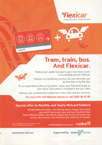 Melbourne Tram Museum
Poster, Yarra Trams, "Tram, train, bus AND Flexicar", c2008
Poster advertising a partnership with Flexicar with Yarra Trams and metlink. Gives details of the Flexicar service and that the monthly Metcard holders would receive a month free access and 1 hour drive time.Demonstrates a Yarra Trams poster regarding allied services.Document - single A4 sheet, colour trams, tramways, yarra trams, flexicar, metlink -
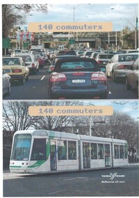 Melbourne Tram Museum
Poster, Yarra Trams, "140 Commuters", c2003
Poster - full colour on off white paper, A4 single sided, titled "140 Commuters", showing a photograph of a crowded road with a rail bridge in the background (Hoddle St Richmond) and C 3035 with the destination of St Kilda Beach on a route 96. Has the Yarra Trams Melbourne all over logo. 2 copies held. See Reg Item 2515.3 for a different version.trams, tramways, yarra trams, hoddle st, richmond, route 96, st kilda beach, c class, tram 3035