Showing 6988 items
matching historical parks
-
 Rutherglen Historical Society
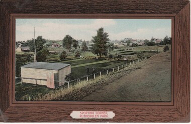
Image, Sporting Corner, Rutherglen Park, 1910 to 1912
Rutherglen Park is located in Murray Street. The grounds shown are now the bowling club. Photo taken from the top of the weir of Lake King.Coloured photograph on a post card, with brown border, showing a view of a one end of the Rutherglen Parksports grounds, rutherglen bowling club, rutherglen park, murray street -
 Rutherglen Historical Society
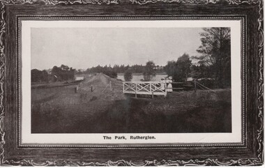
Image, Semco Series, The Park, Rutherglen, 1910 to 1912
Black and white photograph on a post card, with brown border, showing the Rutherglen Park, with a view of the weir and Lake King in the background. In the foreground is the bridge over the weir out-fall, with two ladies on the bridge, one of them holding a baby.rutherglen park, lake king, water storage -
 Rutherglen Historical Society
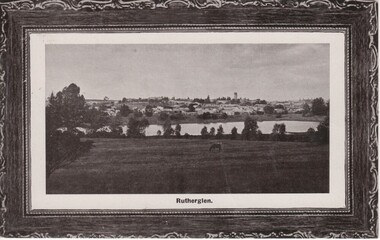
Image, Semco Series, Rutherglen, 1910 to 1912
Black and white photograph on a post card, with brown border, showing a view of Rutherglen taken from the southern side of Lake King.rutherglen park, lake king, rutherglen -
 Rutherglen Historical Society
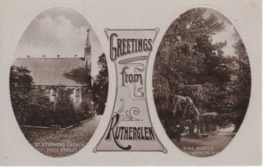
Image, Greetings from Rutherglen, 1910 to 1912
Black and white postcard with two oval photographs with "Greetings from Rutherglen" on a decorative panel between them. The left photograph is of a church. The right one is of pine trees in Rutherglen Park.At bottom of left photograph: "St Stephen's Church. High Street." At bottom of right photograph: "Pine Avenue. Rutherglen Park."st stephens church, rutherglen park, high street, pine avenue -
 Unions Ballarat
Life after gold : twentieth-century Ballarat, Bate, Weston, 1993
... ballarat historical park... ballarat historical park bate, weston Front cover: title and author ...A social history of Ballarat after the decline in gold mining. Includes analysis of population, decline in the local economy and restoring financial fortunes through tourism. Discusses effects upon Ballarat as a result of WWI and WWII.Significant to the history of the Ballarat and the effects of gold mining, tourism and war upon the fortunes of the region. It is a companion to Weston's earlier book, "Lucky City".Book, paper. Cover: yellow background, colour drawing of Sturt Street, Ballarat.Front cover: title and author.social history, economy, ballarat, btlc, ballarat trades hall, ballarat trades and labour council, gold mining, population, tourism, world war i, world war ii, resources, sovereign hill, ballarat historical park, bate, weston -
 Ballarat Heritage Services
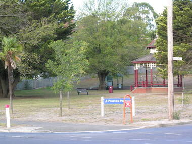
Photograph - Digital photograph, Dorothy Wickham, Pearce's Park, Mount Pleasant
Pearce's Park is at the corner of Barkly and Gladstone Streets, Mount Pleasant, a suburb of Ballarat. It has a children's playground and historical bandstand. See https://www.youtube.com/watch?v=CVN2MStaHgE Isaiah Pearce was an owner of a goldmine and mayor. He built Clowance house in Barkly Street and chose not to build around Lake Wendouree as he thought it was snobbish. Since Pearce's death, the home has been a maternity hospital and a women’s boarding house. It includes a marble-effect entrance, fireplaces, ceilings and cornices. Colour image of Pearce's Park.pearce's park, bandstands, isaiah pearce, mount pleasant -
 Ballarat Heritage Services
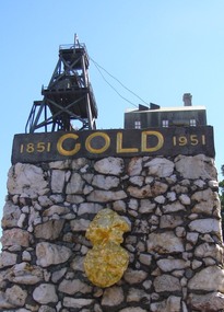
Photograph, Dorothy Wickham, Gold Monument, Ballarat, c2010
Gold was discovered in Ballarat in 1851 when many people rushed to the diggings. A monument commemorates the centenary of the finding of gold at Poverty Point and is dedicated to the memory of pioneer miners of Ballarat. It records gold yields, nuggets and the richest recorded yields of both alluvial and quartz mines. The replica gold nugget on the monument is the `Welcome Nugget`, found in Ballarat in 1858, weighed 2,217 ounces and was sold for £10,500. The memorial, known as the Pioneer Miners’ Monument, was made to commemorate Ballarat's gold centenary. It was proposed that part of the Pioneers' Memorial Fund might be used. This fund was started with £1300 profit from the 1938 centenary celebrations. (Age (Melbourne), The monument was created by John Edward Skilbeck, a toolmaker with Ronaldson and Tippett. John Skilbeck had a deep interest in Ballarat History, and undertook much research with Bert Strange and Keith Stacpoole. Councilllor William Ernest Roff provided the copper for the memorial from scrap copper obtained during his plumbing business. The copper was reworked by John Skilbeck, and was soldered in the kitchen of his home at 14 Frank Street. Colour photograph of the gold monument on the corner of Sturt Street and Albert Street, Ballarat. It commemorates the discovery of gold at Poverty Point in August 1851, and was The monument was unveiled in 1951 and is mainly constructed of large piecesof quartz, with a miniature popper head on the top made of copper. Mounted on the side is a replica of the Welcome Nugget, which was unearthed on the corner of Humffray and Mair Streets, Ballarat on 09 June 1858.FRONT This monument was erected by the Ballarat Historical Society to commemorate the finding of gold at Poverty Point 21st August 1851 and is dedicated to the memory of/ pioneer miners of Ballarat LEFT SIDE Richest recorded yields alluvial mines Band of Hope 303269 Ozs Prince of Wales 168929 Koh I Noor 164157 Great Redan Ex 110111 Albion 107125 Bonshaw Fr 96520 Park 94699 St George 86702 Sir Wm Don 76830 Hand in Hand 76830 Sir Henry Loch 43562 Quartz Mines Star of the East 256758 Ozs Band of Hope 158299 Victoria United 152013 N Woah Hawp 129562 New Normanby 127562 Britannia 103225 Llanberris No 1 100533 Black Hill 91665 Last Chance U 83766 Llanberris 71364 Speedwell 66000 South Star 64444 Sulieman Pasha Companies 62666 RIGHT Recorded gold yield 20606000 ozs Nuggets Alluvial Welcome 2217 ozs Saraha Snads 1619 Lady Hotham 1177 Canadian 1 1117 Canadian 2 1011 Koh 1 Noor 834 Eureka 625 Lady Loch 617 Prince of Wales 606 Bakery Hill 571 Native Youth 540 Faboulous yields of earliest diggings not offically recorded Quartz Nuggets N Woah Hawp 5-- 300 200 Ozs White Horse 500 Woah Hawp 444 266 262 Canton 257 200 Q Victoria lease 410 U Black Hill Coy 315 Tinworths 250 Parade Coy 245gold monument, ballarat, skilbeck, poppet head, j.e. skilbeck, john skilbeck -
 Whitehorse Historical Society Inc.
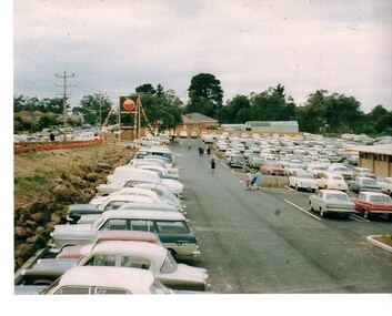
Photograph - Coloured Photograph, Old Orchard Shopping Centre, Blackburn North, 1965
Coloured photograph of cars parked along Springfield Road and in the car park of the Old Orchard Shopping Centre on opening day - October 1965old orchard shopping centre, blackburn shopping centres -
 Whitehorse Historical Society Inc.
Photograph, Mitcham Memorial Hall
The Memorial Hall on Mitcham Road Mitcham, opened officially on Sunday 13 June 1926. The RSL used the hall until 1951, when it was sold to the Nunawading Council to be used as a community facility. In 1993 Nunawading Council sold the hall site.Three coloured photographs a-c of the Mitcham Memorial Hall (demolished). The statue of the soldiers in the foreground has been removed to Halliday Park, Mitcham. Whitehorse Road is in the foreground of each photograph.mitcham memorial hall -
 Whitehorse Historical Society Inc.
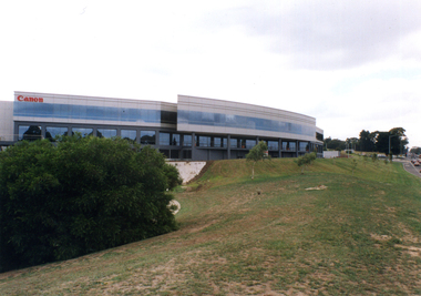
Photograph, Canon
The East Burwood Canon building is at 33 Lakeside Drive, Burwood East. Canon makes cameras, lenses, printers, scanners, video-cameras, photo copiers and so on.Three coloured photographs of the Canon office in Tally Ho Business Park, which is on the corner of Burwood Highway and Springvale Road. One photo shows the western side of the Canon building (with the pond), one shows the curved southern side, and one shows the building looking east from Springvale Road.tally ho business park, east burwood, canon pty ltd -
 Whitehorse Historical Society Inc.
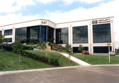
Photograph, Hewlett Packard
Hewlett Packard are particularly proud of the use of glass in their building, and its solar qualities. They produce printers, computers, scanners and digital photographic equipment etc2 coloured photographs (a+b) of the Victorian Headquarters of Hewlett Packard in East Burwood. It is located in the Tally Ho Business Park in East Burwood. The number 347 is prominent as is the Hewlett Packard sign on the right,tally ho business park, east burwood, hewlett packard -
 Whitehorse Historical Society Inc.
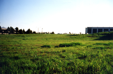
Photograph, Tally Ho Business Park
Tally Ho Business Park was developed by Land Lease, commencing in 1988, and then CGA Bryson from the late 1990's. It was completed in 2002. The land on which it stands was previously the site of the Tally Ho Boys Home. This home was run, from 1903-1986 by the Wesley Central Mission, which caters for boys from the slums. It closed in 1986.Coloured photograph of Tally Ho Business Park in the early stages, looking north towards Burwood Highway.tally ho business park east burwood -
 Whitehorse Historical Society Inc.
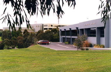
Photograph, Tally Ho Technology Park
Coloured photograph of Tally Ho Technology Park. Grey building with cars parked in parking area. Grassy area in foreground, Other businesses in foreground.tally ho technology park, east burwood. -
 Whitehorse Historical Society Inc.
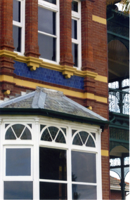
Photograph, Bundoora Park Homestead
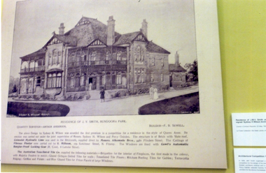
In 1899 John Vincent Smith acquired the property known as 'Bundoora Park'. In the same year he organised a public competition for a design for a house to be built on the property. The competition (worth $50) was won by architect Sydney Herbert Wilson who also designed the Malvern Town Hall. In 1990 a fourteen room mansion was erected. The Australia Tesselated Tile Co of Mitcham supplied most of the tiles for the walls and floors, and Griffins and Lilials for the roof decoration.Coloured photograph detailing the history of Bundoora Park Homestead, Bundoora. Features a drawing of the mansion. The Australian Tesselated Tile Co. Pty Ltd of Mitcham supplied tiles and other materials.bundoora park homestead, australian tesselated tile co pty ltd, tiles -
 Whitehorse Historical Society Inc.
Photograph, Bundoora Park Homestead
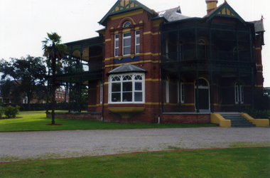
The Tesselated Tile Company of Mitcham was responsible for providing many decorative tiles, terracotta ornaments and roofing tiles for the building.Coloured photograph of the front and left side of Bundoora Park Homestead, Bundoorabundoora park homestead, australian tesselated tile co. pty ltd, tiles -
 Whitehorse Historical Society Inc.
Photograph, Bundoora Park Homestead
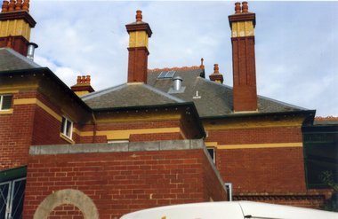
In 1900, Mr J. V. Smith, the owner of Bundoora Park, organised a public competition for a design, in the Queen Ann style, for a mansion to be situated on the property. Australian Tesselated Tile Co. of Mitcham supplied many of the tiles and decorations for the building.Coloured photograph showing the detail on the roof and chimneys at Bundoora Park Homestead, Bundoorabundoora park homestead, australian tesselated tile co. pty ltd, tiles -
 Whitehorse Historical Society Inc.
Photograph, Bundoora Park Homestead
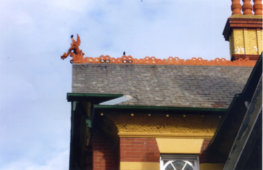
Coloured photograph of a section of the roof at Bundoora Park, Bundoora, showing ornamental detailing and a griffin, which was supplied by the Australian Tesselated Tile Co. of Mitchambundoora park homestead, australian tesselated tile co. pty ltd, tiles -
 Whitehorse Historical Society Inc.
Photograph, Bundoora Park Homestead
Coloured photograph of the front section of Bundoora Park Homestead, Bundoora. Roofing tiles and blue glazed tiles were supplied by Australian Tesselated Tile Co. Mitcham.bundoora park homestead, australia's tesselated tile co. pty ltd, tiles -
 Whitehorse Historical Society Inc.
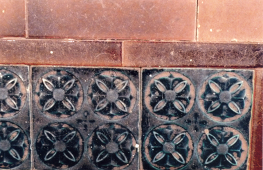
Photograph, Bundoora Park Homestead
7 photographs (a-g) of some of the decorative tiles used at Bundoora Park Homestead, Bundoora that were supplied by the Australian tesselated Tiles Co. Mitchambundoora park homestead, australian tesselated tile co. pty ltd, tiles -
 Whitehorse Historical Society Inc.
Photograph, Mitcham Railway Station
Coloured photograph of cars in the car park on the south side of the Mitcham Railway Station. The view is looking east towards Mitcham Road - 2012mitcham railway station, parking, transport -
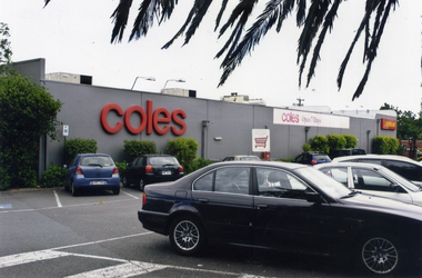 Whitehorse Historical Society Inc.
Photograph, Coles Supermarket, Mitcham
Coloured photograph showing part of the Coles Supermarket and the carpark on the eastern side of the building facing Mitcham Road.mitcham shopping centre, parking, car parks, coles supermarket, mitcham -
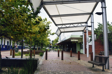 Whitehorse Historical Society Inc.
Photograph, Brittania Mall Mitcham
The Brittania Mall was part of a $5 million development of the Mitcham Shopping centre, begun in 1986. It affected both Edward Street and Brittania Street, part of which had to be re-routed. The guide hall in Brittania Street was removed to Halliday Park Mitcham. The development included extension of the New World Supermarket(now Coles) and a two level carpark.Coloured photograph of the Britannia Mall, Mitcham taken from the north end. Traffic in the distance is on Whitehorse Road - 2012shops, britannia mall, mitcham -
 Whitehorse Historical Society Inc.
Photograph, Blackburn Railway Line, 2012
See NP3406Coloured photograph of the railway line near the Blackburn station, heading west towards the 'city' - 2012. Car park to right.blackburn railway station, transport -
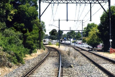
 Whitehorse Historical Society Inc.
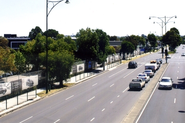
Photograph, Whitehorse Road, Blackburn, 2012
The property on the left of Whitehorse Road was once the Cottees factory. It later became the Leader Newspaper headquarters. It was next owned by Lexus Motor Sales and is now used (2014) as a storage yard with the eastern end used by Leader Newspaper as a staff car park.Coloured photograph of Whitehorse Road, Blackburn - 2012. Cars waiting to turn right into Surrey Road.whitehorse road, blackburn, roads -
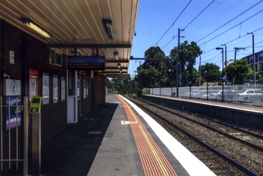 Whitehorse Historical Society Inc.
Photograph, Blackburn Railway Station
Coloured photograph taken of the southern side of the Blackburn Railway station looking west towards the city. Car park to the right is accessed from the Railway Road, Blackburnblackburn railway station -
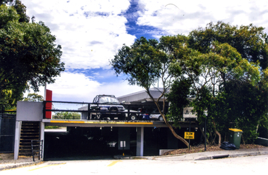 Whitehorse Historical Society Inc.
Photograph, Mitcham Shopping Centre Car Park, 2012
Coloured photograph of the 2-tire car park that serves the Mitcham shops on the north side of the Whitehorse Road. Shows both levels-2012mitcham shopping centre car park, car parks -
 Whitehorse Historical Society Inc.
Photograph, Mitcham Railway Station, 2012
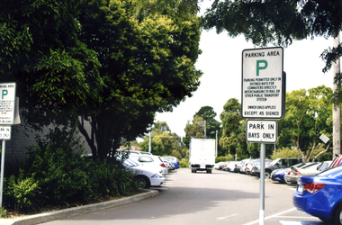
Coloured photograph of the carp park on the north side of the Mitcham Station - 2012. Station reconstructed underground 2013. White truck in the centre.mitcham railway station, mitcham station car park, car parks -
 Whitehorse Historical Society Inc.
Photograph, Mitcham Railway Station construction 2013-14
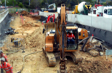
The original Mitcham Station was opened on 25th December 1882. Until the 1970s a shunting yard and goods shed existed where the southern car park is now. Tracks remained embedded in the car park for many years. In 1979 boom gates were provided at both Mitcham Road and Rooks Road. From December 2009 to January 2010 Mitcham Railway Station was used as a bus interchange when the realignment of tracks and construction of a new station occurred at Nunawading. The new Mitcham Station opened on 25th January 2014.Coloured photographs of the construction of the underground railway station at Mitcham in 2013-14 and the opening in 2014.mitcham railway station construction 2013-14, mitcham railway station opening 2014, mitcham railway station, rialway stations -
 Whitehorse Historical Society Inc.
Photograph, Mitcham Football Club 1962
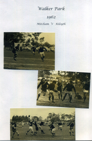
Photograph showing three snapshots of the game Mitcham V Kilsyth in 1962 at Walker Parkmitcham football club, sporting clubs, football clubs -
 Whitehorse Historical Society Inc.
Photograph - Black and white photograph, Vermont shops
A black and white photograph of shops in Vermont. Sign on corner reads Vermont. Sign on building reads general store, car parked out front. Wet day. Pannams' store.vermont shops, shops vermont, general store, pannams 'store