Showing 7593 items
matching post office.
-
 Ballarat Heritage Services
Photograph - Colour, Stonework, Old Sarum, England, English Heritage Site, 2016, 01 November 2016
... Ballarat Heritage Services PO Box 2209 Bakery Hill Post ...William the Conqueror inherited Old Sarum from the last Saxon king of England. It was an ideal site for a royal castle. It was here in 1070 that William paid off his army after a long and bitter campaign in northern England. It was here in 1086 that he called together all the major landholders in England so they could swear allegiance to him. It was a crucial moment. The Domesday Book was being written, a threatened Viking invasion had only just been averted and William's eldest son was in armed rebellion. Old Sarum was an important place where this Norman king of England held power. In 1794 the Ordnance Survey set out to check the accuracy of the first mapping of Southern England, which had begun ten years earlier. From a point just below Old Sarum Lieutenant William Mudge laid out a base-line 36,574 feet (11,253 metres) long. From each end of the line the positions of distant places were plotted using a huge theodolite made in 1791 by Jesse Ramsden. The accuracy of the process, which was repeated all over England, depended on Jesse Ramsden's craftsmanship and on William Mudge's surveying skill in setting out this first base-line from Old Sarum. The nearer end of Mudge's line is marked by an inscribed stone beside the modern A345 at Old Sarum. ordnance survey, william mudge, jesse ramsden, william the conqueror, old sarum, saxon, 1086, england -
 Ballarat Heritage Services
Photograph - Colour, L.J. Gervasoni, Former Bank of Victoria, Avoca, 2011, 06/08/2011
... Ballarat Heritage Services PO Box 2209 Bakery Hill Post ...Colour photograph of the Castlemaine Swimming Pool. avoca, avoca war memorial -
 Ballarat Heritage Services
Photograph - Colour, looking from Stonework towards earth mounds, Old Sarum, England, English Heritage Site, 2016, 01 November 2016
... Ballarat Heritage Services PO Box 2209 Bakery Hill Post ...William the Conqueror inherited Old Sarum from the last Saxon king of England. It was an ideal site for a royal castle. It was here in 1070 that William paid off his army after a long and bitter campaign in northern England. It was here in 1086 that he called together all the major landholders in England so they could swear allegiance to him. It was a crucial moment. The Domesday Book was being written, a threatened Viking invasion had only just been averted and William's eldest son was in armed rebellion. Old Sarum was an important place where this Norman king of England held power. In 1794 the Ordnance Survey set out to check the accuracy of the first mapping of Southern England, which had begun ten years earlier. From a point just below Old Sarum Lieutenant William Mudge laid out a base-line 36,574 feet (11,253 metres) long. From each end of the line the positions of distant places were plotted using a huge theodolite made in 1791 by Jesse Ramsden. The accuracy of the process, which was repeated all over England, depended on Jesse Ramsden's craftsmanship and on William Mudge's surveying skill in setting out this first base-line from Old Sarum. The nearer end of Mudge's line is marked by an inscribed stone beside the modern A345 at Old Sarum. ordnance survey, william mudge, jesse ramsden, william the conqueror, old sarum, saxon, 1086, england -
 Ballarat Heritage Services
Photograph - Colour, Looking from Stonework towards people walking on earth mounds, Old Sarum, England, English Heritage Site, 2016, 01 November 2016
... Ballarat Heritage Services PO Box 2209 Bakery Hill Post ...William the Conqueror inherited Old Sarum from the last Saxon king of England. It was an ideal site for a royal castle. It was here in 1070 that William paid off his army after a long and bitter campaign in northern England. It was here in 1086 that he called together all the major landholders in England so they could swear allegiance to him. It was a crucial moment. The Domesday Book was being written, a threatened Viking invasion had only just been averted and William's eldest son was in armed rebellion. Old Sarum was an important place where this Norman king of England held power. In 1794 the Ordnance Survey set out to check the accuracy of the first mapping of Southern England, which had begun ten years earlier. From a point just below Old Sarum Lieutenant William Mudge laid out a base-line 36,574 feet (11,253 metres) long. From each end of the line the positions of distant places were plotted using a huge theodolite made in 1791 by Jesse Ramsden. The accuracy of the process, which was repeated all over England, depended on Jesse Ramsden's craftsmanship and on William Mudge's surveying skill in setting out this first base-line from Old Sarum. The nearer end of Mudge's line is marked by an inscribed stone beside the modern A345 at Old Sarum. ordnance survey, william mudge, jesse ramsden, william the conqueror, old sarum, saxon, 1086, england -
 Ballarat Heritage Services
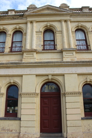
Photograph - Photograph - Colour, L.J. Gervasoni, Former Bank of Victoria, Avoca, 2011, 06/08/2011
... Ballarat Heritage Services PO Box 2209 Bakery Hill Post ...The Former Bank of Victoria in Avoca was built c1854.Colour photograph of the Former Bank of Victoria, Avoca. avoca, former bank of victoria -
 Ballarat Heritage Services
Photograph - Colour, Stairs, Old Sarum, England, English Heritage Site, 2016, 01 November 2016
... Ballarat Heritage Services PO Box 2209 Bakery Hill Post ...William the Conqueror inherited Old Sarum from the last Saxon king of England. It was an ideal site for a royal castle. It was here in 1070 that William paid off his army after a long and bitter campaign in northern England. It was here in 1086 that he called together all the major landholders in England so they could swear allegiance to him. It was a crucial moment. The Domesday Book was being written, a threatened Viking invasion had only just been averted and William's eldest son was in armed rebellion. Old Sarum was an important place where this Norman king of England held power. In 1794 the Ordnance Survey set out to check the accuracy of the first mapping of Southern England, which had begun ten years earlier. From a point just below Old Sarum Lieutenant William Mudge laid out a base-line 36,574 feet (11,253 metres) long. From each end of the line the positions of distant places were plotted using a huge theodolite made in 1791 by Jesse Ramsden. The accuracy of the process, which was repeated all over England, depended on Jesse Ramsden's craftsmanship and on William Mudge's surveying skill in setting out this first base-line from Old Sarum. The nearer end of Mudge's line is marked by an inscribed stone beside the modern A345 at Old Sarum. ordnance survey, william mudge, jesse ramsden, william the conqueror, old sarum, saxon, 1086, england -
 Ballarat Heritage Services
Photograph - Colour, L.J. Gervasoni, Avoca Newsagency, 2011, 06/08/2011
... Ballarat Heritage Services PO Box 2209 Bakery Hill Post ...Colour photograph of the Avoca Newsagency.avoca, newsagency -
 Ballarat Heritage Services
Photograph - Colour, Public toilets hidden in earth mound, Old Sarum, England, English Heritage Site, 2016, 01 November 2016
... Ballarat Heritage Services PO Box 2209 Bakery Hill Post ...William the Conqueror inherited Old Sarum from the last Saxon king of England. It was an ideal site for a royal castle. It was here in 1070 that William paid off his army after a long and bitter campaign in northern England. It was here in 1086 that he called together all the major landholders in England so they could swear allegiance to him. It was a crucial moment. The Domesday Book was being written, a threatened Viking invasion had only just been averted and William's eldest son was in armed rebellion. Old Sarum was an important place where this Norman king of England held power. In 1794 the Ordnance Survey set out to check the accuracy of the first mapping of Southern England, which had begun ten years earlier. From a point just below Old Sarum Lieutenant William Mudge laid out a base-line 36,574 feet (11,253 metres) long. From each end of the line the positions of distant places were plotted using a huge theodolite made in 1791 by Jesse Ramsden. The accuracy of the process, which was repeated all over England, depended on Jesse Ramsden's craftsmanship and on William Mudge's surveying skill in setting out this first base-line from Old Sarum. The nearer end of Mudge's line is marked by an inscribed stone beside the modern A345 at Old Sarum. ordnance survey, william mudge, jesse ramsden, william the conqueror, old sarum, saxon, 1086, england -
 Ballarat Heritage Services
Photograph - Colour, Entrance to Public toilets hidden in earth mound, Old Sarum, England, English Heritage Site, 2016, 01 November 2016
... Ballarat Heritage Services PO Box 2209 Bakery Hill Post ...William the Conqueror inherited Old Sarum from the last Saxon king of England. It was an ideal site for a royal castle. It was here in 1070 that William paid off his army after a long and bitter campaign in northern England. It was here in 1086 that he called together all the major landholders in England so they could swear allegiance to him. It was a crucial moment. The Domesday Book was being written, a threatened Viking invasion had only just been averted and William's eldest son was in armed rebellion. Old Sarum was an important place where this Norman king of England held power. In 1794 the Ordnance Survey set out to check the accuracy of the first mapping of Southern England, which had begun ten years earlier. From a point just below Old Sarum Lieutenant William Mudge laid out a base-line 36,574 feet (11,253 metres) long. From each end of the line the positions of distant places were plotted using a huge theodolite made in 1791 by Jesse Ramsden. The accuracy of the process, which was repeated all over England, depended on Jesse Ramsden's craftsmanship and on William Mudge's surveying skill in setting out this first base-line from Old Sarum. The nearer end of Mudge's line is marked by an inscribed stone beside the modern A345 at Old Sarum. ordnance survey, william mudge, jesse ramsden, william the conqueror, old sarum, saxon, 1086, england -
 Ballarat Heritage Services
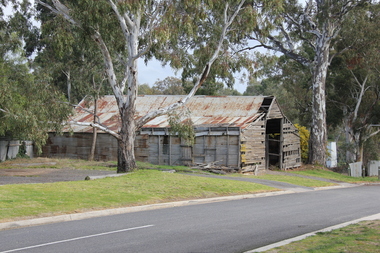
Photograph - Colour, Avoca Shed, 2011, 06/08/2011
... Ballarat Heritage Services PO Box 2209 Bakery Hill Post ...Colour photograph of an old timber shed at Avoca, Victoria.avoca, shed -
 Ballarat Heritage Services
Photograph - Colour, Masons' Marks, Old Sarum, England, English Heritage Site, 2016, 01 November 2016
... Ballarat Heritage Services PO Box 2209 Bakery Hill Post ...William the Conqueror inherited Old Sarum from the last Saxon king of England. It was an ideal site for a royal castle. It was here in 1070 that William paid off his army after a long and bitter campaign in northern England. It was here in 1086 that he called together all the major landholders in England so they could swear allegiance to him. It was a crucial moment. The Domesday Book was being written, a threatened Viking invasion had only just been averted and William's eldest son was in armed rebellion. Old Sarum was an important place where this Norman king of England held power. In 1794 the Ordnance Survey set out to check the accuracy of the first mapping of Southern England, which had begun ten years earlier. From a point just below Old Sarum Lieutenant William Mudge laid out a base-line 36,574 feet (11,253 metres) long. From each end of the line the positions of distant places were plotted using a huge theodolite made in 1791 by Jesse Ramsden. The accuracy of the process, which was repeated all over England, depended on Jesse Ramsden's craftsmanship and on William Mudge's surveying skill in setting out this first base-line from Old Sarum. The nearer end of Mudge's line is marked by an inscribed stone beside the modern A345 at Old Sarum. ordnance survey, william mudge, jesse ramsden, william the conqueror, old sarum, saxon, 1086, england -
 Ballarat Heritage Services
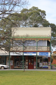
Photograph - Colour, L.J. Gervasoni, Avoca, 2011, 06/08/2011
... Ballarat Heritage Services PO Box 2209 Bakery Hill Post ...Colour photograph of a streetscape in Avoca.avoca, shops -
 Ballarat Heritage Services
Photograph - Colour, L.J. Gervasoni, Avoca, 2011, 06/08/2011
... Ballarat Heritage Services PO Box 2209 Bakery Hill Post ...avoca -
 Ballarat Heritage Services
Photograph - Colour, Masons' Marks, Old Sarum, England, English Heritage Site, 2016, 01 November 2016
... Ballarat Heritage Services PO Box 2209 Bakery Hill Post ...William the Conqueror inherited Old Sarum from the last Saxon king of England. It was an ideal site for a royal castle. It was here in 1070 that William paid off his army after a long and bitter campaign in northern England. It was here in 1086 that he called together all the major landholders in England so they could swear allegiance to him. It was a crucial moment. The Domesday Book was being written, a threatened Viking invasion had only just been averted and William's eldest son was in armed rebellion. Old Sarum was an important place where this Norman king of England held power. In 1794 the Ordnance Survey set out to check the accuracy of the first mapping of Southern England, which had begun ten years earlier. From a point just below Old Sarum Lieutenant William Mudge laid out a base-line 36,574 feet (11,253 metres) long. From each end of the line the positions of distant places were plotted using a huge theodolite made in 1791 by Jesse Ramsden. The accuracy of the process, which was repeated all over England, depended on Jesse Ramsden's craftsmanship and on William Mudge's surveying skill in setting out this first base-line from Old Sarum. The nearer end of Mudge's line is marked by an inscribed stone beside the modern A345 at Old Sarum. ordnance survey, william mudge, jesse ramsden, william the conqueror, old sarum, saxon, 1086, england -
 Ballarat Heritage Services
Photograph - Colour, Masons' Marks, Old Sarum, England, English Heritage Site, 01 November 2016
... Ballarat Heritage Services PO Box 2209 Bakery Hill Post ...William the Conqueror inherited Old Sarum from the last Saxon king of England. It was an ideal site for a royal castle. It was here in 1070 that William paid off his army after a long and bitter campaign in northern England. It was here in 1086 that he called together all the major landholders in England so they could swear allegiance to him. It was a crucial moment. The Domesday Book was being written, a threatened Viking invasion had only just been averted and William's eldest son was in armed rebellion. Old Sarum was an important place where this Norman king of England held power. In 1794 the Ordnance Survey set out to check the accuracy of the first mapping of Southern England, which had begun ten years earlier. From a point just below Old Sarum Lieutenant William Mudge laid out a base-line 36,574 feet (11,253 metres) long. From each end of the line the positions of distant places were plotted using a huge theodolite made in 1791 by Jesse Ramsden. The accuracy of the process, which was repeated all over England, depended on Jesse Ramsden's craftsmanship and on William Mudge's surveying skill in setting out this first base-line from Old Sarum. The nearer end of Mudge's line is marked by an inscribed stone beside the modern A345 at Old Sarum. ordnance survey, william mudge, jesse ramsden, william the conqueror, old sarum, saxon, 1086, england -
 Ballarat Heritage Services
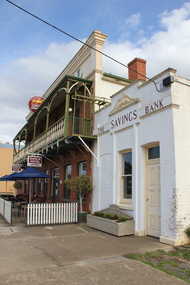
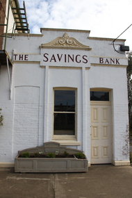
Photograph - Photograph - Colour, L.J. Gervasoni, The Savings Bank, Avoca, 2011, 06/08/2011
... Ballarat Heritage Services PO Box 2209 Bakery Hill Post ...Colour photograph of the former Savings Bank in Avoca.avoca, the savings bank -
 Ballarat Heritage Services
Photograph - Colour, Masons' Marks, Old Sarum, England, English Heritage Site, 2016, 01 November 2016
... Ballarat Heritage Services PO Box 2209 Bakery Hill Post ...William the Conqueror inherited Old Sarum from the last Saxon king of England. It was an ideal site for a royal castle. It was here in 1070 that William paid off his army after a long and bitter campaign in northern England. It was here in 1086 that he called together all the major landholders in England so they could swear allegiance to him. It was a crucial moment. The Domesday Book was being written, a threatened Viking invasion had only just been averted and William's eldest son was in armed rebellion. Old Sarum was an important place where this Norman king of England held power. In 1794 the Ordnance Survey set out to check the accuracy of the first mapping of Southern England, which had begun ten years earlier. From a point just below Old Sarum Lieutenant William Mudge laid out a base-line 36,574 feet (11,253 metres) long. From each end of the line the positions of distant places were plotted using a huge theodolite made in 1791 by Jesse Ramsden. The accuracy of the process, which was repeated all over England, depended on Jesse Ramsden's craftsmanship and on William Mudge's surveying skill in setting out this first base-line from Old Sarum. The nearer end of Mudge's line is marked by an inscribed stone beside the modern A345 at Old Sarum. ordnance survey, william mudge, jesse ramsden, william the conqueror, old sarum, saxon, 1086, england -
 Ballarat Heritage Services
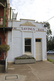
Photograph - Photograph - Colour, L.J. Gervasoni, The Savings Bank, Avoca, 2011, 06/08/2011
... Ballarat Heritage Services PO Box 2209 Bakery Hill Post ...avoca, the savings bank -
 Ballarat Heritage Services
Photograph - Colour, Masons' Marks, Old Sarum, England, English Heritage Site, 2016, 01 November 2016
... Ballarat Heritage Services PO Box 2209 Bakery Hill Post ...William the Conqueror inherited Old Sarum from the last Saxon king of England. It was an ideal site for a royal castle. It was here in 1070 that William paid off his army after a long and bitter campaign in northern England. It was here in 1086 that he called together all the major landholders in England so they could swear allegiance to him. It was a crucial moment. The Domesday Book was being written, a threatened Viking invasion had only just been averted and William's eldest son was in armed rebellion. Old Sarum was an important place where this Norman king of England held power. In 1794 the Ordnance Survey set out to check the accuracy of the first mapping of Southern England, which had begun ten years earlier. From a point just below Old Sarum Lieutenant William Mudge laid out a base-line 36,574 feet (11,253 metres) long. From each end of the line the positions of distant places were plotted using a huge theodolite made in 1791 by Jesse Ramsden. The accuracy of the process, which was repeated all over England, depended on Jesse Ramsden's craftsmanship and on William Mudge's surveying skill in setting out this first base-line from Old Sarum. The nearer end of Mudge's line is marked by an inscribed stone beside the modern A345 at Old Sarum. ordnance survey, william mudge, jesse ramsden, william the conqueror, old sarum, saxon, 1086, england -
 Ballarat Heritage Services
Photograph - Photograph - Colour, Cutty Sark vessel and exhibition, Greenwich, England, 06/11/2016
... Ballarat Heritage Services PO Box 2209 Bakery Hill Post ...The Cutty Sark was launched on 22 November 1869. She was named by the wife of George Moodie, the ship's first master who had also supervised her construction. Cutty Sark left the Clyde on 13 January 1870. A month and two days later, she set sail from London for China. Cutty sark was designed and built by Scott & Linton of Dumbarton for 16,150 pounds. But much of the money was to be paid by Willis when the ship was launched. Just before they finished her, Scott & Linton ran out of money and went bankrupt. She was completed by William Denny & Brothers. The Cutty Sark was the first ship to reach London with a tea cargo in 1877. But she was one of only nine sailing ships that returned that year - in 1870 there had been 59. Steamships were now dominating the tea trade. In 1883 the Cutty Sark joined the booming trade in transporting Australian wool. Every year until 1895 she set out in the summer for Australia, to load a cargo of wool bales and return to England in time for the wool sales ini the first three months of the new year. Cutty Sark soon established herself as the fastest of the wool clippers. Under her last master, Richard Woodget she set record times of 70 days or less for the voyage which no other sailing ships could match.Colour photograph of the Cutty Sark at Greenwich, England. cutty sark vessel and exhibition, greenwich, england, dumbartion, william denny, tea, immigration, trade, scott and linton, ship, vessel, boat, sailing ship -
 Ballarat Heritage Services
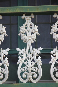
Photograph - Photograph - Colour, Avoca Cast Iron Lace, 2011, 06/08/2011
... Ballarat Heritage Services PO Box 2209 Bakery Hill Post ...Colour photograph of cast iron in Avoca, Victoriaavoca, cast iron lace, hotel -
 Ballarat Heritage Services
Photograph - Photograph - Colour, L.J. Gervasoni, Avoca, 2011, 06/08/2011
... Ballarat Heritage Services PO Box 2209 Bakery Hill Post ...Colour photograph of a double storey brick building in Avoca, Victoria.avoca, architecture -
 Ballarat Heritage Services
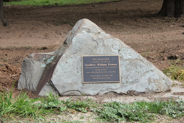
Photograph - Photograph - Colour, L.J. Gervasoni, Geoffrey William Powers Memorial, Avoca, 2011, 06/08/2011
... Ballarat Heritage Services PO Box 2209 Bakery Hill Post ...Geoffrey Powers who was tireless worker for the Avoca community and a playground was named in his honour.Colour photograph of the Geoffrey William Powers Memorial in Avoca.This playground is dedicated to the memory of Geoffrey William Powers Geoff worked tirelessly for the Avoca community. Through his efforts many similar projects have been accomplished. Officially opened 2nd October 1994. From the citizens of Avoca. avoca, memorial, plaque, geoffrey william powers -
 Ballarat Heritage Services
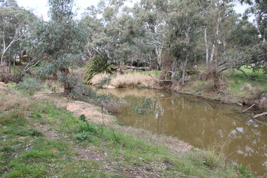
Photograph - Photograph - Colour, L.J. Gervasoni, River at Avoca, 2011, 06/08/2011
... Ballarat Heritage Services PO Box 2209 Bakery Hill Post ...Colour photograph of a pre-olympic swimming pool in the river at Avoca, Victoria.avoca, pre-olympic swimming pool, avoca sswimming pool -
 Ballarat Heritage Services
Photograph - Colour, L.J. Gervasoni, River at Avoca, 2011, 06/08/2011
... Ballarat Heritage Services PO Box 2209 Bakery Hill Post ...avoca, pre-olympic swimming pool -
 Ballarat Heritage Services
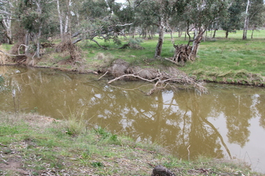
Photograph - Colour, L.J. Gervasoni, River at Avoca, 2011, 06/08/2011
... Ballarat Heritage Services PO Box 2209 Bakery Hill Post ...Colour photograph of the swimming hole in the River at Avoca. avoca, pre-olympic swimming pool, avoca river -
 Ballarat Heritage Services
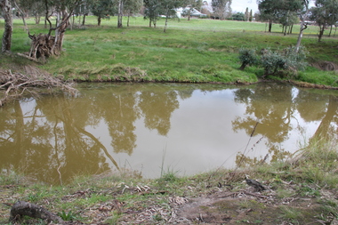
Photograph - Colour, L.J. Gervasoni, River at Avoca, 2011, 06/08/2011
... Ballarat Heritage Services PO Box 2209 Bakery Hill Post ...avoca, pre-olympic swimming pool -
 Ballarat Heritage Services
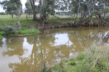
Photograph - Colour, L.J. Gervasoni, River at Avoca, 2011, 06/08/2011
... Ballarat Heritage Services PO Box 2209 Bakery Hill Post ...avoca, pre-olympic swimming pool -
 Ballarat Heritage Services
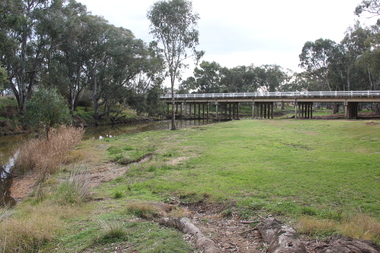
Photograph - Colour, L.J. Gervasoni, Bridge Over the River, Avoca, 2011, 06/08/2011
... Ballarat Heritage Services PO Box 2209 Bakery Hill Post ...avoca, bridge, avoca river