Showing 30762 items matching "hill "
-
 Whitehorse Historical Society Inc.
Document - Report, The Pound House, 1998
Report on The Pound House, 988 Canterbury Road, Box Hill South, by Andrew Ward, architectural historian.Report on The Pound House, 988 Canterbury Road, Box Hill South, by Andrew Ward, architectural historian. The report details the history of the site which was the first Shire Hall of the Shire of Nunawading and then the residence of the pound keeper. The building is described. Photographs. 7 pages.Report on The Pound House, 988 Canterbury Road, Box Hill South, by Andrew Ward, architectural historian. bills, annis, george, fairbanks, g, j, bennett, s, bishop, edward, bayley, leonard sherwin, blood, robert, norman & hayes, kennedy, bob, city of box hill, shire of nunawading -
 Whitehorse Historical Society Inc.
Article, Heritage Overlay - Formal ATV-0, 2017
The Minister for Planning has approved amendment C157 (Part 2) to the Whitehorse Planning Scheme which applies a Heritage Overlay HO 272 partially over the site at 104 -168 Hawthorn Road, Forest Hill (Former ATV 0 Television Studios)heritage overlay, city of whitehorse, hawthorn road, forest hill no. 104 -168, television stations, channel 0 tv studios -
 Whitehorse Historical Society Inc.
Photograph, Tombstone - McGlone family
John and Eliza McGlone ran one of the earliest hotels in Mitcham - the Harvest Home - in the front room of their house in Whitehorse Road. The hotel closed in 1889 and John McGlone died in 1892. Eliza McGlone continued as Mitcham's first official Post-mistressColoured photo of one side of tombstone on grave 95, Roman Catholic section, Box Hill Cemetery McGlone, John died 3 September 1892, aged 63 years McGlone, Eliza died 2 January 1921, aged 85 yearsmcglone, john, eliza, tombstones, harvest home hotel -
 Ballarat Heritage Services
Photograph - Photograph - Colour, Clare Gervasoni, Yarrowee Creek after days of heavy rain, 2016, 17/09/2016
A number of photographs of the Yarrowee River after days of heavy rain. Two and three day previously the water reached the edges of the channel and was flowing very fast. The photographs were taken from and around the Hill Street Bridge near the Sunnyside Woollen Mills.yarrowee creek, yarrowee river, bridge, chanel, hill street, ballarat east -
 Mt Dandenong & District Historical Society Inc.
Photograph, St. Michael and All Angels Anglican Church c1970, c1970
St Michael and All Angels Anglican Church in the Parish of Mt Dandenong sited on the corner of Falls Road and the Mt Dandenong Tourist Road, Kalorama. The church was built in 1940. For further information see 'A Light In The Hills', 2 editions by Henry L. Speagle.falls road, mt. dandenong tourist road, st. michael's church, st. michael and all angels anglican church, anglican church, henry l. speagle -
 South Gippsland Shire Council
Photograph, colour, Last Light at Mount Best, 2006
Framed colour photograph titled " Last Night at Mount Best" The landscape features a red building in the centre of green rolling hills. Black card window mount. Glossy black timber frame. Two gold screws with nylon hanging cord on back . -
 Southern Sherbrooke Historical Society Inc.
Photograph - Narre Warren East School 1959
Black and white photo of the entire enrollment at Narre Warren East School in 1959. Thirty-one children sit and stand in four rows with trees and hills in the background. Photo copied from Edna Boothroyd whose family lived next door to the school. -
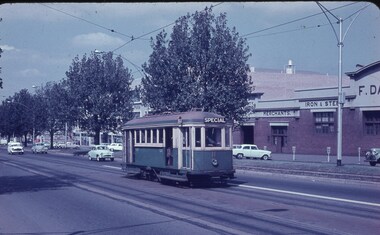
 Ballarat Tramway Museum
Photograph - Digital image, Peter Bruce, "No. 14 Sturt", 1970s
Yields information about Sturt St between Lydiard St and Grenville St, part of the Victoria St route..Digital image, black and white, of No 14 descending the Sturt St hill to Grenville St, enroute to Victoria St. Photo taken by Peter Bruce 1970's and 1971, prior to the closure of the Ballarat tramway system. Peter's Title of image: "No. 14 Sturt"trams, tramways, sturt st, victoria st, tram 14 -
 Bendigo Historical Society Inc.
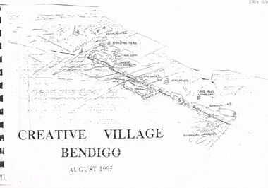
Document - MERLE HALL COLLECTION: DOCUMENTS RELATING TO CREATIIVE VILLAGE BENDIGO
Documents relating to Creative Village Bendigo - Cover? to bound printed material entitled ''Creative Village Bendigo - August 1995'' (with ink sketch of area from Victoria Hill to Botanical Gardens ); Page 2 with sections describing Introduction; The Design Team and Acknowledgements. -
 Bendigo Historical Society Inc.
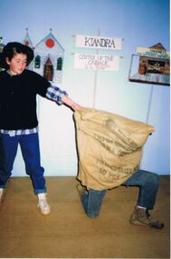
Photograph - PETER ELLIS COLLECTION: GRAVEL HILL PRIMARY SCHOOL
Colour photograph. Children in costume. Hessian sack. Jeans. Boots. Kiandra. Center of the outback with dragons so go slow. Sweeney's general store and universal emporium. Painted scenery. Church. Gravel Hill Primary School. 1988 Production 'The Wallaby Track''.photo, group, children in costume -
 Bendigo Historical Society Inc.
Book - WHITE HILLS BOTANIC GARDENS BENDIGO - 1857-2007, 2008
18 page soft cover booklet 'White Hills Botanic Gardens Bendigo 1857-2007'. An illustrated history of the Botanic Gardens compiled by Judy Milner on behalf of friends of the Bendigo Botanic Gardens. Published 2008 and printed by BMP total image management.Judy Milner -
 Bendigo Historical Society Inc.
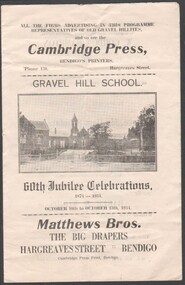
Programme - 60TH JUBILEE CELEBRATIONS 1874 - 1934 FOR GRAVEL HILL SCHOOL HELD 10 - 13TH OCTOBER 1934, 1934
60th Jubilee Celebrations, 1874 - 1934, for Gravel Hill School held 10 - 13th October 1934 Two sheets, with many local business advertisments, centre spread for Diamond Jubilee Fair on Friday 12th October 1934 at 2:30 PM -
 Ballarat Tramway Museum
Slide - 35mm slide/s, Keith Kings, 14/03/1964 12:00:00 AM
Bendigo, No. 7 Night exposure at Bendigo North terminus on 14-3-1964. Destination sign showing Quarry Hill. Has two ads on front dash and tram has been fitted with dash canopy lights etc. Photo by Keith Kings.Stamped on 'K.S.Kings etc.' and in blue ink 'K(k)(420), 14/3/1964, Bendigo No. 7, ex Ballarat 19, North terminus, 15secs f3.5, 60feet.tramways, trams, bendigo, north bendigo, tram 7 -
![Ceramic - Artwork- Ceramic, [Wood Fired Pot] by John Crump](/media/collectors/530576742162ef0fa09a2288/items/534748179821f420f8c03a55/item-media/58527e3bd0cdf11b7444a648/item-fit-380x285.jpg) Federation University Art Collection
Federation University Art CollectionCeramic - Artwork- Ceramic, [Wood Fired Pot] by John Crump
Samuel John CRUMP John Crump obtained a Diploma in Art (Pottery) in 1968 at the Ballarat Technical Art School. He lectured in ceramics at Ballarat Teachers' College (1972-1976) and State College Victoria Ballarat (1976 and 1991), as well as making functional stoneware, decorative and architectural forms and ceramic panels. This item is part of the Federation University Art Collection. The Art Collection features over 1000 works and was listed as a 'Ballarat Treasure' in 2007.Wheel thrown pot with burnished Black Hill ochre slip over a local stoneware body. The pot was woodfired to 1300 degrees celcius in a Hoffman kiln. Gift of John Crump in memory of Barbara Crump, Head of the School of Education Teaching Resource Centre.Incised on base 'Crump'art, artwork, john crump, ceramics, wood fired, black hill, local clay -
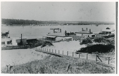 Lakes Entrance Historical Society
Photograph - Carpentertown, 1900c
Also four other black and white copies, one size 12 x 18 cm, two size 9 x 14 cm, and one size 10 x 15 cm, one of which was purchased from Helen ClothierBlack and white photograph showing buildings on dunes, and township of Lakes Entrance across lake, Cunninghame Arm. Buildings from left are school, harbour masters house, harbour engineer's house. Boardwalk in foreground. Kalimna Hill in background. Lakes Entrance Victoriawaterways, vegetation, topography, township, historic buildings -
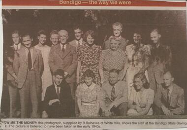 Bendigo Historical Society Inc.
Newspaper - JENNY FOLEY COLLECTION: SHOW ME THE MONEY
BHS CollectionBendigo Advertiser ''The way we were'' from 2002. Show me the money: this photograph, supplied by B. Balnaves of White Hills, shows the staff at the Bendigo State Saving Bank. The picture is believed to have been taken in the early 1940s. The clip is in a folder.newspaper, bendigo advertiser, the way we were -
 Melbourne Tram Museum
Slide, Keith Caldwell, 13/03/1963 12:00:00 AM
Agfa Colour slide, cardboard, by Keith Caldwell dated 13-3-1962 of ex Sydney Scrubber climbing the Elizabeth St hill to the Haymarket roundabout. Tram in the green colour scheme. Has in the background the F. Dank's hardware merchants building in the background.In ink "Car 11 13-3-1962"trams, tramways, elizabeth st, scrubber tram, work trams -
 Melbourne Tram Museum
Negative, Ellis Collection, c1956
Negative (120) of a view of a W7? crossing the Merri Creek Bridge in Queens Parade Clifton Hill - notes provide date of 1956. A low resolution A4 laminated was received with the negatives. Hi Res image filed in the dbtext/hawthtramcoll/Large Images/htd3588large.jpgtrams, tramways, queens parade, clifton hill, merri creek, bridges -
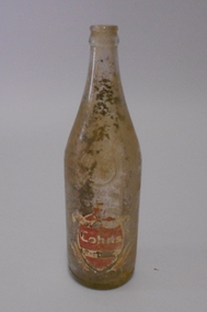 Bendigo Historical Society Inc.
Container - COHNS SOFT DRINK BOTTLE
Glass bottle. 'Cohns' sticker on side of bottle. written on side 'bottle is not sold but remains the property of Cohns Limited Bendigo and Swan Hill, net contents 26 fl ozs. preservative added artificially coloured. Bottle is in poor condition,dirt inside.bendigo, business, cohn bros -
 Whitehorse Historical Society Inc.
Book, Suburban heartland, 2010
A history of the City of Whitehorse and its two former cities, City of Box Hill and City of Nunawading.A history of the City of Whitehorse and its two former cities, City of Box Hill and City of Nunawading. The aim of the new history is not to replace separate histories of each city, previously published but to meld together the area's shared history and to bring the story up to the present.A history of the City of Whitehorse and its two former cities, City of Box Hill and City of Nunawading. city of nunawading, city of box hill, city of whitehorse -
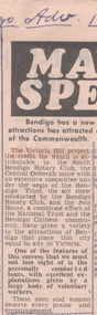 Bendigo Historical Society Inc.
Newspaper - VICTORIA HILL - VICTORIA HILL PROJECT
Newspaper article under the heading 'Mayor Speaks' in the Bendigo Advertiser dated 17th April 1971. ''The Victoria Hill Project, the credit for which is attributable to the South Bendigo Rotary Club, the Central Deborah Mine with an extensive committee under the aegis of the Bendigo Trust.newspaper, bendigo advertiser, victoria hill, victoria hill project, bendigo advertiser 17/4/1971, south bendigo rotary club, central deborah mine, bendigo trust -
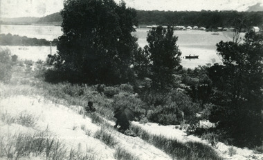 Lakes Entrance Historical Society
Photograph - Township, Cunninghame Arm, Lakes Entrance Victoria, 1910c
Black and white photograph of the township, taken from the hummocks. It shows a person sitting under a black umbrella on a sand hill in the foreground, Cunninghame Arm, two persons in rowboat on water, buildings along Esplanade, Kalimna Heights in background. Lakes Entrance Victoriatopography, waterways, township -
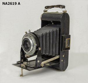 Whitehorse Historical Society Inc.
Equipment - Camera
Owned by W.H.Arrowsmith, father of Ted Arrowsmith, and purchased by W.H Arrowsmith in the late 1940s and used by him until the late 1960s. He lived in 11 Maple Street Box Hill, 35 Cambridge Street Box Hill and Minna Street Blackburn.KODAK BROWNIE 620 Camera ANASTON black folding. Folds back into narrow case with handle. Box and instruction book included.ANASTON F/6.3 mount 370 Kodak London 100mm|DAKON shutter Brownie.photography, cameras -
Surrey Hills Historical Society Collection
Work on paper - Amery, Bruce
An assignment compiled by Amanda Wallington of Luther College in 1999 as part of the WW1 history course of teacher Bernie Nitschke. Several students studied servicemen from the Surrey Hills area. The students presented their research at a meeting of the Surrey Hills Historical Society.A vertical file containing the following information regarding : 1. Donald Bruce Amery - 'In the footsteps of an Anzac', Amanda Wallington, 1999 - 20 pages in a blue folder. bruce amery, world war 1, amanda wallington, luther college, bernie nitschke, donald bruce amery -
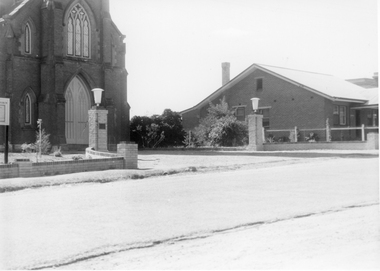 Stawell Historical Society Inc
Photograph, St. Matthew’s Church Memorial Entrance
Memorial entrance to St. Matthew’s Church. Erected by family of Robert Hill McCracken. Plaque inscription - To the Glory of God, and in memory of Robert Hill McCracken. Session clerk of this Church 1935 - 1955. The brick dwelling on the right is the Baptist Manse built 1935.Black & white photo of entrance to a Church with a building next door.stawell religion -
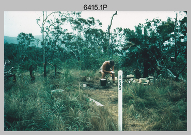 Bendigo Military Museum
Photograph - Royal Australian Survey Corps Surveyors in the Field – North Queensland and Torres Strait, 1961
This is a set of five photographs of surveyors and support staff in the field undertaking duties in North Queensland and Torres Strait in 1961. The surveyors were employed in the establishment of mapping and geodetic control. In this era surveyors used theodolites to observe horizontal and vertical angles and tellurometers to measure base line distances between survey stations. In photo .2P Joe Farrington is seen taking survey observations using a Tavistock V500 Series Tavistock theodolite at a survey station between the Edward River and Aurukun in the Cape York Peninsula. The Gulf of Carpentaria appears in the background. From 1957 helicopter transport of survey parties revolutionised transport in remote areas. The civilian helicopter was hired from TAA. This is a set of five photographs of surveyors and support staff in the field undertaking duties in North Queensland and Torres Strait in 1961. The photographs were printed on photographic paper and are part of the Army Survey Regiment’s Collection. The photographs were scanned at 300 dpi. .1) - Photo, colour, 1961. Andy Millar occupying a survey station on a hill in the Cape York Peninsula, QLD. .2) - Photo, colour, 1961. Joe Farrington taking observations with a V500 Series Tavistock geodetic theodolite at a survey station in the Cape York Peninsula, QLD. .3) - Photo, colour, 1961. Daryl Parker taking a break from survey observations on a hill located on Duaun Island QLD, in the Torres Strait, a few miles south of the PNG coastline. Hill height was 975 ft. .4) - Photo, colour, 1961. Three Torres Strait divers L to R: unidentified, Darku and Ray Mau Daryl standing behind a Tavistock geodetic theodolite on a hill located on Duaun Island QLD, in the Torres Strait, a few miles south of the PNG coastline. .5) - Photo, colour, 1961. Andy Millar holding meat from a small turtle on Duaun Island QLD, in the Torres Strait, a few miles south of the PNG coastline. An unidentified Duaun Island local appears in the background..1P to .5P annotated on back – personnel names, the year and the location. royal australian survey corps, rasvy, army survey regiment, asr, army svy regt, fortuna, surveying -
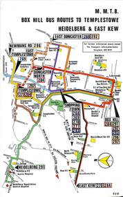 Melbourne Tram Museum
Map, Melbourne & Metropolitan Tramways Board (MMTB), Set of 8 bus route maps, 1977 to 1979
Series of colour route maps for various bus or groups of tram lines for the MMTB. Some have the Transport Information Centre telephone printed on them, others have a label stuck on. Some are finished with a plastic laminate finish on either one or both sides. Show the major cross streets, parks, schools, other tram routes, major stop numbers and railway lines. .1 - Box Hill bus routes to Templestowe - R38/82, Heidelberg and East Kew, includes Doncaster, Shoppingtown and Newmans Road. .2 - Clifton Hill - R2/79 - Elsternwick, Point Ormond and St Kilda Junction .3 - Footscray, Sunshine, Deer Park, Nth Altona, Fishermen's Bend, Highpoint and Williamstown Road - R2/79. .4 - Bulleen - City - Port Melbourne - Garden City Bus Route, including Kew, Collingwood - R6/78 .5 - City - Warrandyte and East Doncaster including Newmans Road, Templestowe, East Doncaster, Donvale, Shopping town, and Kew. R3/82. .6 - West Heidelberg, La Trobe University, Northland - R3/81 .7 - Box Hill, Ringwood to East Doncaster and Warrandyte, Park Orchards, North Blackburn R3/82. .8 - Geelong - Herne Hill, Rollins Road, Donnybrook Rd, North Shore and Corio Villagetrams, tramways, maps, route guide, route numbers, routes, buses, box hill, templestowe, doncaster, east kew, heidelberg, clifton hill, point ormond, elsternwick, footscray, sunshine, deer park, north altona, fishermen's bend, highpoint, williamstown rd, bulleen, kew, collingwood, port melbourne, garden city, warrandyte, donvale, la trobe university, northland, ringwood, park orchards, mitcham, blackburn, geelong -
 Flagstaff Hill Maritime Museum and Village
Photograph, before 1911
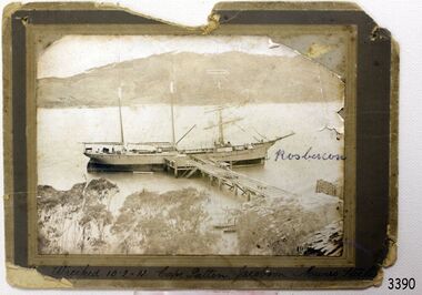
Photograph, black and white, of the three-masted barque SPECULANT at a jetty in low water. On the jetty and the shore are stacks of cut timber. The ship is in a wide river or bay, hills in the background, trees (like gum trees) in the foreground. Inscribed "Wrecked 10.2.11. Cape Patten. Jacobson. Munro. - - - -" Written on the photograph in blue pen "Rosbercon". (The SPECULANT was wrecked on 10th February 2011 at Cape Patton, Victoria, (not Patten as on the photograph). She was sailing under the control of Captain James Jacobsen and her First Mate was James Mumro.) The barquentine SPECULANT was a steel, three-masted sailing ship built in 1895 in Inverkeithing, Scotland, registered in Warrnambool, Victoria and wrecked at Cape Paton, Victoria, 10th February 1911. The SPECULANT had been involved in the timber trade between the United Kingdom and Russia, until sold to its Warrnambool owners and timber merchants Messrs. P.J. McGennan & Co. (Peter John McGennan) in 1902 for 3000 pounds and had her sailed to Warrnambool as her new port. Peter John McGennan was born in 1844 and worked as a builder and cooper in Holyhead, Anglesea, Wales. He immigrated to Australia in 1869 as a free settler and arrived in Warrnambool in 1871 and undertook management of a property in Grassmere for Mr. Palmer. Peter met his wife Emily in South Melbourne and they married in 1873. They had ten children including Harry who lived to 1965, and Andrew who lived until 1958. (The other children were their four brothers - John who was killed in the Dardenalles aged 35, Frederick who died aged 8, Peter who died aged 28, Frank who died aged 5 weeks - and four sisters - Beatrice who died age 89, Edith who died aged 49, Blanche who died aged 89 and Eveline who died aged 48.) In 1874 Peter starting a boating establishment on the Hopkins River. In 1875 he opened up a Coopers business in Kepler Street next to what was Bateman, Smith and Co., moving to Liebig Street, next to the Victoria Hotel, in 1877. In 1882 he then moved to Lava Street (which in later years was the site of Chandlers Hardware Store). He was associated with the establishment of the Butter Factory at Allansford. He started making Butter Boxes to his own design and cheese batts for the Butter Factory. In 1896 established a Box Factory in Davis Street Merrivale, employing 24 people at its peak, (it was burnt down in 1923); and in Pertobe Road from 1912 (now the Army Barracks building). Peter was a Borough Councillor for Albert Ward from 1885 to 1891, he commenced the Foreshore Trust (including the camping grounds along Pertobe Road), and he was an inaugural Director of the Woollen Mill in Harris Street, buying an extensive share-holding in 1908 from the share trader Edward Vidler. They lobbied the Town Hall to have a formal ‘Cutting’ for the waters of the Merri River to be redirected from its natural opening south of Dennington, to its existing opening near Viaduct Road, in order to have the scourings from the wool at the Woollen Mill discharged into the sea. He sold Butter Boxes around the state, and had to ship them to Melbourne by rail. Peter’s purchase of the SPECULANT in 1902 enabled him to back-load white pine from Kaipara, New Zealand to Warrnambool to make his butter boxes then, to gain profitability, buy and ship potatoes and other primary produce bound to Melbourne. (McGennan & Co. had also owned the LA BELLA, which had traded in timber as well, until she was tragically wrecked with the loss of seven lives, after missing the entrance channel to Warrnambool harbour in 1905. It appears that the SPECULANT was bought to replace the LA BELLA.) In 1911 the SPECULANT had been attempting to depart Warrnambool for almost the entire month of January to undergo docking and overhaul in Melbourne. A month of east and south-easterly winds had forced her to remain sheltered in Lady Bay, Warrnambool apart from one morning of northerlies, when an attempt was made to round Cape Otway; she had to return to shelter in Portland after failing to make any headway. With only 140 tons of sand ballast aboard, the ship would not have been easy to handle. Captain Jacobsen and his crew of nine, mainly Swedes, decided to make for Melbourne, leaving Portland Harbour on 5th February 1911. By the 9th they had reached Cape Otway, where they encountered a moonless night, constant heavy rain, and a heavy sea with a south-easterly wind blowing. After safely rounding Cape Otway the course was changed to east, then north-east to take the vessel to a point six miles off Cape Patton, following the orders of Captain Jacobsen, who told the crew to be very careful with the steering, as the wind and sea was running to leeward. The patent log (used to measure speed) had been out of order for the last four months as no-one in Warrnambool was able to fix it: it was intended to have it repaired in Melbourne. In the meantime the crew measured the vessel's speed by looking over the side and estimating wind strength. This compounded the difficulties of imprecise positioning, as the strong cross wind and sea were acting on the lightly laden vessel to steadily drive it towards the shore. At 3.30am on Friday 10 February 1911 Captain Jacobsen and the first mate were looking over the side of the vessel when they heard the sound of breakers and suddenly struck the rocks. The crew immediately knew they had no chance of getting the SPECULANT off, and attempted to rescue themselves by launching the lifeboat, which was instantly smashed to pieces. One of the crew then volunteered to take a line ashore, and the rest of the crew were all able to drag themselves to shore, some suffering hand lacerations from the rocks. Once ashore they began to walk along the coast towards Lorne, believing it was the nearest settlement. Realising their mistake as dawn broke they returned westwards to Cape Patton, and found a farm belonging to Mr C. Ramsden, who took them in and gave them a change of clothes and food. After resting for a day and returning to the wreck to salvage some of their personal possessions, at 10am on Saturday they set out for Apollo Bay, a voyage that took six hours, sometimes wading through flooded creeks up to their necks. The Age described the wreck as "listed to starboard. All the cabin is gutted and the ballast gone. There is a big rock right through the bottom of her, and there is not the slightest hope of getting her off". A Board of Marine inquiry found that Captain Jacobson was guilty of careless navigation by not taking steps to accurately verify the position of the vessel with respect to Cape Otway when the light was visible and by not setting a safe and proper course with respect to the wind and sea. It suspended his certificate for 6 months and ordered him to pay costs. The location of the wreck site was marked for a long time by two anchors on the shoreline, until in 1970 the larger of the two anchors was recovered by the Underwater Explorers' Club and mounted on the foreshore at Apollo Bay. The bell from the wreck was also donated to the Apollo Bay Surf Lifesaving Club but is recorded to have been stolen. Rusting remains of the wreck can still be found on the shoreline on the southern side of, and directly below Cape Patton. Parts of the SPECULANT site have been buried by rubble from construction and maintenance works to the Great Ocean Road, as well as by naturally occurring landslides. Peter J McGennan passed away in 1920. The Gates in the western wall of the Anglican Church in Henna Street/Koroit St are dedicated to him for his time of community work, which is matched with other prominent Warrnambool citizens; Fletcher Jones, John Younger, J.D.E (Tag) Walter, and Edward Vidler. After Peter J McGennan's death Harry, Andrew and Edith continued to operate the family business until July 11th 1923 when the company was wound up. (Andrew lived in Ryot Street Warrnambool, near Lava Street.) Harry McGennan (Peter and Emily’s son) owned the Criterion Hotel in Kepler Street Warrnambool (now demolished). His son Sid and wife Dot lived in 28 Howard Street (corner of Nelson Street) and Sid managed the Criterion until it was decided by the family to sell, and for he remained Manager for the new owners until he retired. Harry commenced the Foreshore Trust in Warrnambool around 1950. The McGennan Carpark in Pertobe Road is named after Harry and there are Memorial-Stone Gates in his memory. (The Gates were once the original entrance to the carpark but are now the exit.). Peter’s great-grandson, also called Andrew, is a Security Officer in Warrnambool. The Patent Log (also called a Taffrail log) from the SPECULANT, mentioned above, and a number of photographs, are now part of the Collection at Flagstaff Hill Maritime Village. The SPECULANT is historically significant as the largest ship to have been registered in Warrnambool, and is believed to have been the largest barquentine to visit Melbourne. It is evidence of the final days of large commercial sailing vessels involved in the Victorian and New Zealand timber trade. The SPECULANT is listed on the Victorian Heritage Register VHR S626Photograph, black and white, of the three-masted barque SPECULANT at a jetty in low water. On the jetty and the shore are stacks of cut timber. The ship is in a wide river or bay, hills in the background, trees (like gum trees) in the foreground. Inscribed below photograph "Wrecked 10.2.11. Cape Patten. Jacobson. Munro. - - - -" Written on the photograph in blue pen "Rosbercon"Inscribed below photograph "Wrecked 10.2.11. Cape Patten. Jacobson. Munro. - - - -" Written on the photograph in blue pen "Rosbercon"flagstaff hill, warrnambool, shipwrecked-coast, flagstaff-hill, flagstaff-hill-maritime-museum, maritime-museum, shipwreck-coast, flagstaff-hill-maritime-village, warrnambool historical photograph, cape patten, munro, james munro, la bella, speculant, cumming and ellis, international timber trade, p. j. mcgennan and co. warrnambool, peter mcgennan, capt. james jacobsen, warrnambool maritime history -
 Surrey Hills Historical Society Collection
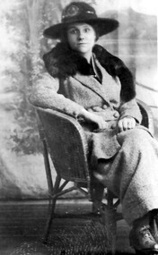
Photograph, Mary Sneddon
Mary was married to William Sneddon who was a postman in Surrey Hills for many years. His father James ran an estate agency in Surrey Hills which had been established by his father, also James, in the 1880s. William married Mary nee Bird in 1903 at his father's home. They lived at 'Cliburn' 14 Suffolk Road, named after Cliburn, Westmorland (later Cumbria) where Mary's mother, Mary Coulston came from. According to the donor, all their homes were given this name. WIlliam and Mary had the following children: Jim (James 3rd) b 1905, Balwyn Jack (John William) b. 1908, Camberwell Norman Alexander b 1910, Camberwell Alan Coulson b 1914, Surrey Hills Jean Isabel b 1916, Surrey Hills Douglas Haig b 1918, Surrey Hills. William and Mary are buried in Box Hill Cemetery: P-061-0033. The donor Robin da Costa-Adams is related to the Sneddon family through her first marriage. Formal sepia photo of Mary Sneddon seated in a studio or against a backdrop provided by a travelling photographer. "Mary Sneddon" - Robin da Costa-Adams' hand in grey lead pencil. "nee Bird) / (wife of Wm Sneddon" in black ink in Jocelyn Hall's hand.(miss) mary bird, (mrs) mary sneddon, william sneddon -
 Eltham District Historical Society Inc
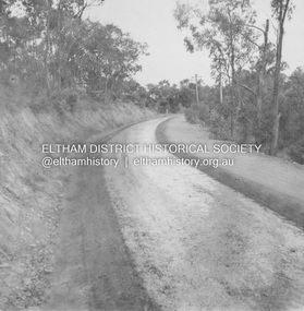
Album - Photograph, J.A. McDonald, Research-Warrandyte Road, Sep. 1958
Between Blooms Road and Sloans Hill Primed – April 1956Record of various Shire of Eltham infrastructure works undertaken during the period of 1952-1962 involving bridge and road reconstruction projects, sometimes with Eltham Shire Council Project Reference numbers quoted. It was during this period that a number of significant improvements were made to roads and new bridges constructed within the shire that remain in place as of present day (2022). In many situations, the photos provide a tangible visible record of infrastructure that existed throughout the early days of the Shire. The album was put together by or under the direction of the Shire Engineer, J.A. McDonald.infrastructure, shire of eltham, bridge construction, road construction, 1956-04, research-warrandyte road