Showing 5924 items
matching east road
-
 Lakes Entrance Historical Society
Photograph - Roadknight Street View, 2000 c
Avenue of Queensland brush box trees planted as memorial to John Carpenter pioneer builder of Lakes EntranceColour photograph of Roadknight Street looking east towards Whiter Street and crossroads Mourilyan Street and Stock Street before Norfolk Pine was removed early 2000s Lakes Entrance Victoriaroads and streets -
![Photograph - Construction of the F19 [Eastern Freeway], Ron Setford, 1971](/media/collectors/550653872162f11fb04854aa/items/67cbd1c0494c4da380441bb3/item-media/67cbd350494c4da380442242/item-fit-380x285.jpg) Kew Historical Society Inc
Kew Historical Society IncPhotograph - Construction of the F19 [Eastern Freeway], Ron Setford, 1971
Ron Setford and his wife Grace Setford lived in Tanner Avenue, East Kew, from c.1946 to c.1995. A keen photographer, he recorded the changing face of Kew over a 20 year period. Apart from 30 photographs of built structures and places in Kew dating from 1960 and 1961, 145 of his 35mm colour slides chronicle the development of the F19 (later renamed Eastern) Freeway through the Yarra Valley in Kew over a five year period from c.1972 to c.1977. This important collection was donated to the Society by his granddaughter in 2025.This collection of 175 35mm slides is of local and statewide significance, owing to its subject matter, particularly the major development of road transport infrastructure during the 1970s with the construction of the Eastern Freeway. The photographer also took care to annotate and date most of his slides which enable the researcher to pinpoint temporal and spatial locations."Royal Talbot, left to Kew East, right to Alphington"ron setford, eastern freeway, f19 freeway -
 Bendigo Historical Society Inc.
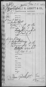
Administrative record - Abbott Collection: Jan to Jun 1893: records and receipts for purchases by J.H. Abbott & Co
various 1893 company letterhead receipts2403.86 (A to G) Abbott Collection: Jan to Jun 1893: records and receipts for purchases by J.H. Abbott & Co. from a wide range of generally Melbourne based companies 2043.86A 40 records held by J.H. Abbott & Co. Jan to Jun 1893: for purchases (or sales) 2403.86B 10 receipts for purchases by J.H. Abbott & Co. from Thomas P. Power, Saddlers, Ironmongers & Manufacturers398-400 Little Bourke St Melbourne 2403.86C 10 receipts for purchases by J.H. Abbott from The India Rubber, Gutta Percha & Telegraph Works Co. 106 Cannon St London 2403.86D 4 receipts for purchases by J.H. Abbott & Co. from Cashel, Baxter & Co., 508 Collins Str Melbourne 2403.86E 7 receipts for purchases by J.H. Abbott from Ullathorne & Co., 269 Lonsdale St Melbourne 2403.86F 5 receipts for purchases by J.H. Abbott from Michaelis, Hallenstein & Co, Tanners, Curriers & Leather Merchants, Importers of Grindery, 382-384 Lonsdale St Melbourne 2403.86G 14 receipts for purchases by J.H. Abbott from a variety of companies: Nobel's Hamburg Dynamite Co. Ltd. - gelignite Thomas Mitchell, Paint & General Brush Manufacturers357 Lonsdale St Melbourne R.M. Watson & Co. 345 Flinders Lane Melbourne; Paper Makers, Agents, Stationers and Importers (two receipts) Wm Dodgshun & Sons, 258 &260 Flinders Lane, East Melbourne; Importers & Warehousemen (two receipts) The New Zealand Loan & Mercantile Agency Company Limited, Collins Street West, Melbourne; Melbourne Wool & Grain Warehouses Walter H. Carwardine, Bendigo Soap, Soda Crystal & candle Works, near the Municipal Cattle Yards J. Kitchen & Sons & Apollo Company; 326 Flinders Lane, Melbourne J. Kennon & Sons, Tanners, Curriers & Leather Merchants; Tannery, River St., near Hawthorn Bridge Innes - Noad V. Halfden (!!!), Tea Merchants & Importers; 201 1to 205 William Street, Melbourne The Indian Company, Lubricating Oil Merchants; Normanby Road, South Melbourne; 375 Flinders Lane, corner Queen Street, Melbourne A. Spooner Manufacturer of Improved Harness Composition, Improved Black Oil, Harness Liquid, Waterproof Harness Blacking, saddle Soap, Boot Top Powder (all colours), Polishing Cream, Breeches Paste, Universal Cream and Embrocations. Australian Asbestos Mfg Co. 266 Flinders St Easttrade company purchases 1893 -
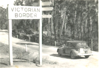 Lakes Entrance Historical Society
Postcard, Victorian Border sign East Gippsland Victoria, 1940 c
Black and white postcard showing a sedan driving by the Victorian Border sign East Gippsland Victoriaroads and streets, topography, vehicles -
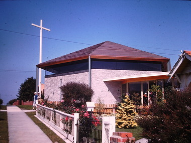 Kew Historical Society Inc
Photograph - St Paul's Church, Kew East, Ron Setford, 1961
Ron Setford and his wife Grace Setford lived in Tanner Avenue, East Kew, from c.1946 to c.1995. A keen photographer, he recorded the changing face of Kew over a 20 year period. Apart from 30 photographs of built structures and places in Kew dating from 1960 and 1961, 145 of his 35mm colour slides chronicle the development of the Eastern Freeway through the Yarra Valley over a five year period from c.1972 to c.1977. This important collection was donated to the Society by his granddaughter in 2025.This collection of 175 35mm slides is of local and statewide significance, owing to its subject matter, particularly the major development of road transport infrastructure during the 1970s with the construction of the Eastern Freeway. The photographer also took care to annotate and date most of his slides which enable the researcher to pinpoint temporal and spatial locations.Nilron setford, photographs -- kew (vic.) -- 1960s, st paul's church -- kew east (vic.) -
 Whitehorse Historical Society Inc.
Map - Parish Map, Parish of Nunawading, 1892
... include the Koonung Creek between Elgar Road and Springvale Road ...A map copied from 'Directory maps - parishes and counties' dated 26 Nov 1892. Compiled and lithographed by G.S. Bonney. The map includes roads, railway, stations, names of property owners. It has a scale [ca. 1:31,680] 40 chains to an 1 inch.A map copied from 'Directory maps - parishes and counties' dated 26 Nov 1892. Compiled and lithographed by G.S. Bonney. The map includes roads, railway, stations, names of property owners. It has a scale [ca. 1:31,680] 40 chains to an 1 inch.non-fictionA map copied from 'Directory maps - parishes and counties' dated 26 Nov 1892. Compiled and lithographed by G.S. Bonney. The map includes roads, railway, stations, names of property owners. It has a scale [ca. 1:31,680] 40 chains to an 1 inch.maps, parish of nunawading -
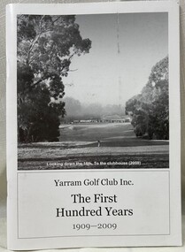 Heidelberg Golf Club
Book, The first 100 years: Yarram Golf Club, 2009
The Yarram Golf Club is situated in Yarram, in south east Gippsland, Victoria. It was first established in 1909 and this book marks the Club's centenary. The Club is located in Golf Links Road Yarram. 48p., illus. (some col.). Paperback.golf clubs- victoria, golf clubs - history, golf clubs - yarram, yarram golf club -
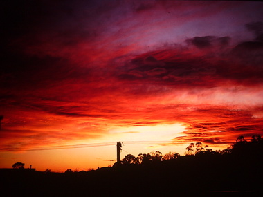 Kew Historical Society Inc
Photograph - Sunrise over Kew East, Ron Setford, 1969
Ron Setford and his wife Grace Setford lived in Tanner Avenue, East Kew, from c.1946 to c.1995. A keen photographer, he recorded the changing face of Kew over a 20 year period. Apart from 30 photographs of built structures and places in Kew dating from 1960 and 1961, 145 of his 35mm colour slides chronicle the development of the Eastern Freeway through the Yarra Valley over a five year period from c.1972 to c.1977. This important collection was donated to the Society by his granddaughter in 2025.This collection of 175 35mm slides is of local and statewide significance, owing to its subject matter, particularly the major development of road transport infrastructure during the 1970s with the construction of the Eastern Freeway. The photographer also took care to annotate and date most of his slides which enable the researcher to pinpoint temporal and spatial locations."Sunrise over East Kew [Aug69}"ron setford, photographs -- kew (vic.) -- 1960s, kew east -
 Ringwood and District Historical Society
Document - Subdivision Map, Part of Crown Portion 22 Parish of Ringwood, County of Mornington. Vol 1915 Fol 827 - LP2427
... Road), and Dynes Street, Ringwood East. Additional Plan... Road), and Dynes Street, Ringwood East. Additional Plan ...LANDATA Land Victoria 4-sheet plan dated January 2003 - copy of original 1889 subdivision, amended with 1947 amendments by Assistant Registrar of Titles.Sheet 1 includes Main Lilydale Road (later Old Lilydale Road), Wandin Road (later Mount Dandenong Road), and Joseph Street, Ringwood East. Additional Plan markings SP30844, SP32804, LP144251, PS332061, PS305232. Sheet 2 includes Main Lilydale Road (later Old Lilydale Road), Wandin Road (later Mount Dandenong Road), and Dynes Street, Ringwood East. Additional Plan markings LP43708, LP44231, LP124702. Sheet 3 includes Main Lilydale Road (later Old Lilydale Road), Dynes Street, Albert Street (later Wyrunga Street), and Carcoola Road, Ringwood East. Additional Plan markings LP114181, LP114180, LP18261, LP214030, LP67300, PS354509, PS335500. Sheet 4 includes Main Lilydale Road (later Old Lilydale Road), Albert Street (later Wyrunga Street), and Carcoola Road, Ringwood East. Additional Plan markings PS315494, PS319495. -
Canterbury History Group
Photograph - Corner view of shops south east facing shop at Maling Road and Bryson Street, Jan Pigot, 27/03/1993 12:00:00 AM
Coloured photograph of the south eastern facing corner of Maling Road and Bryson Street shops entitled The Blockcanterbury, maling road, shops, telegraph poles, victorian architecture, trees -
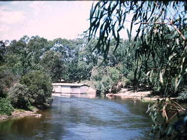 Kew Historical Society Inc
Photograph - Chipperfield's floating 'Pontoon' on the Yarra River, Ron Setford, 1960
Ron Setford and his wife Grace Setford lived in Tanner Avenue, East Kew, from c.1946 to c.1995. A keen photographer, he recorded the changing face of Kew over a 20 year period. Apart from 30 photographs of built structures and places in Kew dating from 1960 and 1961, 145 of his 35mm colour slides chronicle the development of the Eastern Freeway through the Yarra Valley over a five year period from c.1972 to c.1977. This important collection was donated to the Society by his granddaughter in 2025.This collection of 175 35mm slides is of local and statewide significance, owing to its subject matter, particularly the major development of road transport infrastructure during the 1970s with the construction of the Eastern Freeway. The photographer also took care to annotate and date most of his slides which enable the researcher to pinpoint temporal and spatial locations.Nilron setford, photographs -- kew (vic.) -- 1960s, yarra river -- kew east (vic.), chipperfield's boat house, chipperfield's floating pontoon -
 Kew Historical Society Inc
Photograph - Beach near Chipperfield's floating 'Pontoon', Ron Setford, 1960
Ron Setford and his wife Grace Setford lived in Tanner Avenue, East Kew, from c.1946 to c.1995. A keen photographer, he recorded the changing face of Kew over a 20 year period. Apart from 30 photographs of built structures and places in Kew dating from 1960 and 1961, 145 of his 35mm colour slides chronicle the development of the Eastern Freeway through the Yarra Valley over a five year period from c.1972 to c.1977. This important collection was donated to the Society by his granddaughter in 2025.This collection of 175 35mm slides is of local and statewide significance, owing to its subject matter, particularly the major development of road transport infrastructure during the 1970s with the construction of the Eastern Freeway. The photographer also took care to annotate and date most of his slides which enable the researcher to pinpoint temporal and spatial locations.Nilron setford, photographs -- kew (vic.) -- 1960s, yarra river -- kew east (vic.), chipperfield's boat house, chipperfield's floating pontoon -
 Kew Historical Society Inc
Photograph - St Paul's Church, Kew East, Ron Setford, 1961
Ron Setford and his wife Grace Setford lived in Tanner Avenue, East Kew, from c.1946 to c.1995. A keen photographer, he recorded the changing face of Kew over a 20 year period. Apart from 30 photographs of built structures and places in Kew dating from 1960 and 1961, 145 of his 35mm colour slides chronicle the development of the Eastern Freeway through the Yarra Valley over a five year period from c.1972 to c.1977. This important collection was donated to the Society by his granddaughter in 2025.This collection of 175 35mm slides is of local and statewide significance, owing to its subject matter, particularly the major development of road transport infrastructure during the 1970s with the construction of the Eastern Freeway. The photographer also took care to annotate and date most of his slides which enable the researcher to pinpoint temporal and spatial locations.Nilron setford, photographs -- kew (vic.) -- 1960s, st paul's church -- kew east (vic.) -
 Kew Historical Society Inc
Photograph - Yarra River at Kew East, Ron Setford, 1960
Ron Setford and his wife Grace Setford lived in Tanner Avenue, East Kew, from c.1946 to c.1995. A keen photographer, he recorded the changing face of Kew over a 20 year period. Apart from 30 photographs of built structures and places in Kew dating from 1960 and 1961, 145 of his 35mm colour slides chronicle the development of the Eastern Freeway through the Yarra Valley over a five year period from c.1972 to c.1977. This important collection was donated to the Society by his granddaughter in 2025.This collection of 175 35mm slides is of local and statewide significance, owing to its subject matter, particularly the major development of road transport infrastructure during the 1970s with the construction of the Eastern Freeway. The photographer also took care to annotate and date most of his slides which enable the researcher to pinpoint temporal and spatial locations.Nilron setford, photographs -- kew (vic.) -- 1960s, yarra river -- kew east (vic.) -
 Ringwood and District Historical Society
Photograph, C. Gribble, Oliver Pratt's residence and Butchers Shop, Main Road (Opposite Mt.Dandenong Road), Ringwood. Two photos c.1910 and c.1914 (Multiple Copies)
Multiple copies of two photos of Oliver Pratt's residence and butchers shop, Main Road (Opposite Mt.Dandenong Road). Earlier photo shows Mr. Oliver Pratt (Left) and Mr. James Kenneth McCaskill (Right) outside residence (c.1910). Later photo (c.1914) taken after Pratt's first butcher shop was added before subsequent shop established on the corner of Warrandyte Road. (Orignial photo IDs were MHE999, MHE7, F27)Written on back of sepia photograph, "Mr. J. K. McGaskill. Main Road on Pratt's Land?" Typed below another photograph, "Mr. O. J. Pratt's Butcher shop, Main St. east of Warrandyte Rd. - 1912. -
Lakes Entrance Historical Society
Financial record - Ledger, Country Roads Board Wages Ledger, 1953
... A Ledger of Wages paid to Country Roads Board employees...A Ledger of Wages paid to Country Roads Board employees... to Country Roads Board employees of East Gippsland Victoria Country ...A Ledger of Wages paid to Country Roads Board employees of East Gippsland VictoriaA Ledger of Wages paid to Country Roads Board employees of East Gippsland Victoriaaccounts book -
Lakes Entrance Historical Society
Financial record - Ledger, Country Roads Board Wages Ledger, 19450
... A ledger of wages paid to Country Roads Board employees... A ledger of wages paid to Country Roads Board employees of East ...Entries are hand written in ink. All pages are used. Leather bound, heavy cardboard cover, foolscap size.A ledger of wages paid to Country Roads Board employees of East Gippsland Regionaccounts book -
Lakes Entrance Historical Society
Financial record - Ledger, Country Roads Board Wages Ledger, 18050
... A Ledger of Wages paid to Country Roads Board employees... to Country Roads Board employees of East Gippsland Victoria Country ...Entries in ink and hand written, all pages used, leather bound foolscap sizeA Ledger of Wages paid to Country Roads Board employees of East Gippsland Victoriaaccounts book -
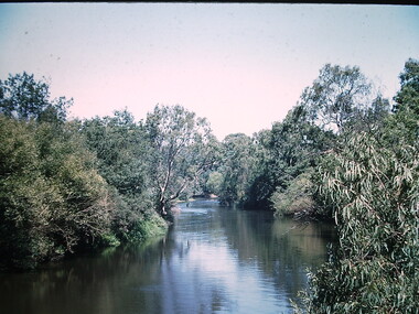
 Lakes Entrance Historical Society
Postcard - Eagle Point bluff, silt Jetties and Jones' Bay, Eagle Point Victoria, A W Burman Bairnsdale, 1912 c
Letter on back dated Dec 30 1912 to Mrs Brewer Signed FloraBlack and white postcard showing view of Mitchell River looking east towards Eagle Point bluff and the silt Jetties and Jones' Bay small farm and buildings, hop kiln on bank opposite bluff and hop paddock. Horse and jinker on gravel road Eagle Point VictoriaMitchell River Eagle Point Bairnsdale waterways, rivers, jetties, roads and streets, transport -
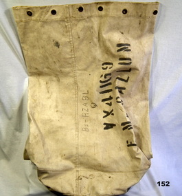 Bendigo Military Museum
Equipment - KIT BAG WW2, 1939
Item issued to Eric MacCALLUM No VX41169, enlisted on 26.6.40, 2/32nd Batt 9th Div AIF, age 31 years 9 months, promoted Cpl 6.8.1940, embarked 15.9.1940 for the Middle East, hospital 25.11.1940 with Haemorhoids, rejoinn unit 17.12.1940, attends Mortar and Grenade schools, hospital 16.8.1941 with PUO, taken POW 17.2.1942 at El Alamein. He served in the Seige of Tobruk, Middle East Campaigns. As a POW it appears he was interred from 1942/43 in Italy then 1943/45 in XV111Austria. He describes his conditions in the camps as fair and that he worked on road works. This is a brief description as to his treatment in his records. Embarked from England 4.7.1945 and disembarked in Sydney on 8.8.1945. Discharged from the 2nd AIF on 12.9.1945.Canvas Kit bag with stenciled name and details on side and base.In handwritten lettering - "B2 - RZABL- Q" Stencilled - "VX41169 E. MacCallum"containers, military equipment -
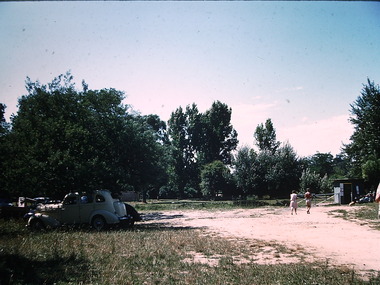
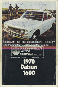 Eltham District Historical Society Inc
Document - Property Binder, 1274 Main Road, Eltham
... Eltham Businesses 1970 Datsun 1600 Brochure Main Road Eltham ...Adverisement: 1970 Datsun 1600, Preswell's Auto Serviceeltham, businesses, 1970 datsun 1600, brochure, main road eltham, presswell's eltham east auto service, property -
 Glen Eira Historical Society
Album - Page 13 of folder D-F, Caulfield Municipality Photo Slide Collection, c.1976 - c.1994
The photographs for the slides are believed to have been taken by the inaugural Editor for the Caulfield Contact - the official newspaper of the former City of Caulfield from 1976-1994. The Editor was also Council's Community Liaison Officer and she (and her successor) took many photographs of official events and Council-related services and locations in connection with both these official roles. The City of Caulfield was the Municipal Council for an area of the South Eastern suburbs of Melbourne, including Brighton East, Carnegie, Caulfield, Elsternwick, Gardenvale, Glen Huntly, McKinnon, Murrumbeena, Ormond and St Kilda East. Credit: Glen Eira Historical Society - This item was digitised and made available through the Glen Eira Heritage Digitisation Strategy 2019-2023. Glen Eira Historical Society acknowledges the support of Glen Eira City Council. Page 13 of slide album D to F, in a polypropylene slide sleeve containing 12 x 35mm colour slides. A sample of 2 images from this page is included. glen eira city council, local government, caulfield city council, caulfield council, city of caulfield, caulfield contact, elsternwick, caulfield municipality photo slide collection, roads and streets, parking, shops, downshire road, glenhuntly road, trams, hopetoun gardens, parks and reserves, cannons -
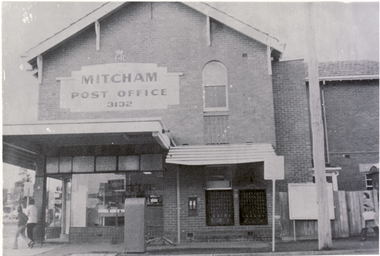 Whitehorse Historical Society Inc.
Photograph - B/W Photograph, Mitcham Post Office, 1/09/1976 12:00:00 AM
(See also NP262 ) Black and white photo of Mitcham Post Office, NE corner of Whitehorse Road and Station Street. Has been site of Mitcham PO for many years - built in 1924. Following the death of Bertha Markham, Postmistress, in 1944, the building was not a PO; it resumed that function in mid 1957: between 1944 and 1957, the post office location was on the same block several buildings to the east of the current site. This building was also the home of Mary Millane (daughter of Bertha Markham) who operated a mixed business here and her husband Harold conducted a studio photographic business from these premises. The Millane family sold the premises to the PMG and vacated the premises in June, 1957, at which time it resumed service as the Mitcham Post Office.mitcham post office -
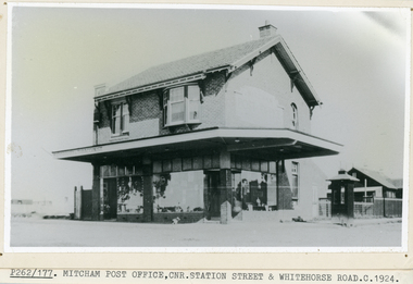 Whitehorse Historical Society Inc.
Photograph, Mitcham Post Office
Black and white photo of Mitcham Post Office built 1924. East Corner Station street and Whitehorse Road. For details, see NP409. See also Button family house in Station Street next to lane now called Quality Way..markham, mary., patrick joseph, mitcham post office -
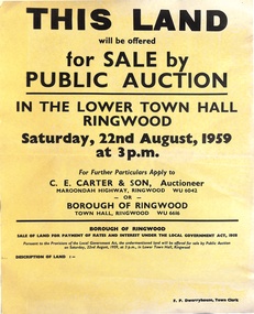 Ringwood and District Historical Society
Poster, Land for Sale by Public Auction, Lower Town Hall, Ringwood - Saturday 22nd August, 1959
Yellow poster and smaller attachment with auction details and summary of four properties offered under Borough of Ringwood instructions for unpaid rates, some with handwritten monetary notations.Lot 49 Patterson Street, East Ringwood (Opp. station). Made Road, Water and E.L. 60'x220' approx. Lot 48 Stoda Street, Heathmont. Water and E.L. 50'x150'. Lot 86 Cnr Heatherbrae & Burwood Avenues, Ringwood. Made roads, Water and E.L. 54'x140' approx. Lot 13 Tagell Road Ringwood. 64'x1130' approx. For further particulars apply to C.E. Carter & Son, Auctioneer, Maroondah Highway, Ringwood (Phone) WU6042, WU6830, or Borough of Ringwood, Town Hall, Ringwood (Phone) WU6616. F.P. Dwerryhouse, Town Clerk. -
 Wodonga & District Historical Society Inc
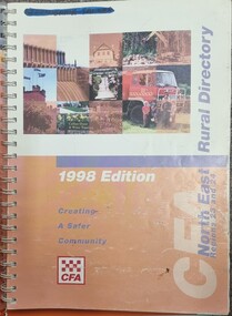
Book - North East Rural Directory 1998
The CFA North East Rural Directory for Regions 23 and 24 was designed to assist fire brigades and other emergency services in responding to calls in the North East region of Victoria. Its purpose was to minimize response times to emergency situations by providing accurate and detailed information about all of the localities in the regions. District 23 is based at Wangaratta and Extends as far south as Woods Point. District 24 is centred in Wodonga and extends past Corryong to the New South Wales border following the Murray River. It also includes Falls Creek and Mount Hotham.A spiral bound volume including colour topographic maps and illustrations of North East Victoria. The cover features a collage of colour photo of North East Victoria including a CFA firefighter in a truck with members of his family beside it. The book also features a key map, explanation of map references and symbols, localities index. Alphabetical road indexes for Wodonga, Albury, Wangaratta and Benalla as well as township maps and alphabetical road indexes for smaller communities are included.The CFA North East Rural Directory for Regions 23 and 24 was designed to assist fire brigades and other emergency services in responding to calls in the North East region of Victoria. Its purpose was to minimize response times to emergency situations by providing accurate and detailed information about all of the localities in the regions. District 23 is based at Wangaratta and Extends as far south as Woods Point. District 24 is centred in Wodonga and extends past Corryong to the New South Wales border following the Murray River. It also includes Falls Creek and Mount Hotham.emergency management north east victoria, cfa region 24, cfa wodonga, cfa region 23 -
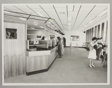 Ringwood and District Historical Society
Photograph, Interior of Ringwood North State Bank , south-east corner of Dickson's Crescent and Warrandyte Road
The new Ringwood North State Bank premises on the south-east corner of Dickson's Crescent. Showing customer service area. Opened 23 August 1982At the corner of Dickson's Cresent and Warrandyte Road, Ringwood North. Photographer - Les Gorrie Photography, 28 Waldemar Road, Heidelberg. Negative #82334 -
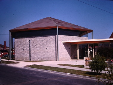
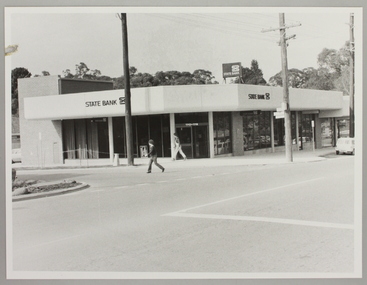
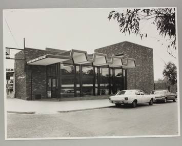 Ringwood and District Historical Society
Photograph, Exterior view of Ringwood North State Bank , north-east corner of Dickson's Crescent and Warrandyte Road
The new Ringwood North State Bank premises on the north-east corner of Dickson's Crescent. Exterior view. Unknown date. Opened 25 October 1971At the corner of Dickson's Crescent and Warrandyte Road, Ringwood North. Photographer Laurie Richards, 4 Tower Avenue, Alphington. Negative #71-3031 -
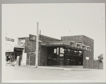 Ringwood and District Historical Society
Photograph, Ringwood North State Bank , north-east corner of Dickson's Crescent and Warrandyte Road
The new Ringwood North State Bank premises, November 1979 on the north-east corner of Dickson's Crescent. Exterior view.At the corner of Dickson's Crescent and Warrandyte Road, Ringwood North. Photographer - Les Gorrie Photography, 28 Waldemar Road, Heidelberg. Negative #2389 -
 Ringwood and District Historical Society
Photograph, Ringwood North State Bank , south-east corner of Dickson's Crescent and Warrandyte Road
Photo of the new Ringwood North State Bank premises, opened 23 January 1983At the corner of Dickson's Crescent and Warrandyte Road, Ringwood North. Photographer - Les Gorrie Photography, 28 Waldemar Road, Heidelberg. Negative #82335