Showing 126749 items
matching main-road
-
 Rutherglen Historical Society
Image, 1900 Approximate
Donated by Mr Greg Thomson, a former resident of RutherglenBlack & white reproduction, unframed, laminated. This photograph is of Main St Rutherglen facing east. At the end of the right hand side in middle of photograph is a small white patch, this is the Chinese camp. Left hand corner is where Fire Station now stands, old Blue Bird Hall is next (now Goodfellows Supermarket)On back of photo: "Main St Rutherglen - facing east"main street, chinese camp, blue bird hall, goodfellows supermarket -
 Glenelg Shire Council Cultural Collection
Magazine - Magazine Article, Australian Off-Road Action, c. 1981
Pages 15 - 26 of 'Australian Off-Road Action' magazine. White, black print and photographs. Pages 16 -26 is an article title 'Portland - the venue' documenting the history of the Portland Dune Buggy Club from its formation inv 1969 -
Whitehorse Historical Society Inc.
Article, The origin of L.L. Road, 1936
Article in Australian Home Beautiful, 1 May 1936 on the origin of L.L. Road, VermontArticle in Australian Home Beautiful, 1 May 1936 on the origin of L.L. Road, Vermont, challenging 'Suburban street names' by Richard Ross which says it ids named after Lewis Luxton, suggesting it is named after Dr L.L. Smith.Article in Australian Home Beautiful, 1 May 1936 on the origin of L.L. Road, Vermontstreet names, ross, richard, smith, l.l. (dr), luxton, lewis, l.l.vale road, vermont, boronia road, vermont -
 Whitehorse Historical Society Inc.
Photograph, Doncaster East Road, Mitcham, No.35, 2006
Coloured photo of south - west side of the Winchcombe family home on the corner of Doncaster East and Glen Roads, Mitcham in 2006 Mrs. Winchcombe, nee Ireland is related to the Ireland family who were orchardists and florist in Mitcham area in the early 1900s.winchcombe family, ireland family, doncaster east road, mitcham, no.35 -
 Kew Historical Society Inc
Print, FGA Barnard, Scenes at Kew Flyer Road Race, 1910
This work forms part of the collection assembled by the historian Dorothy Rogers, that was donated to the Kew Historical Society by her son John Rogers in 2015. The manuscripts, photographs, maps, and documents were sourced by her from both family and local collections or produced as references for her print publications. Many were directly used by Rogers in writing ‘Lovely Old Homes of Kew’ (1961) and 'A History of Kew' (1973), or the numerous articles on local history that she produced for suburban newspapers. Most of the photographs in the collection include detailed annotations in her hand. The Rogers Collection provides a comprehensive insight into the working habits of a historian in the 1960s and 1970s. Together it forms the largest privately-donated collection within the archives of the Kew Historical SocietyTwo photographs related to the Kew Flyer, a bicycle shop in Kew that sponsored a major road race in the first decades of the 20th century. The images were published in Barnard's 'Jubilee History of Kew' (1910) from which Dorothy Rogers sourced the image.Kew Flyer outing. 1 mention - Mansfield's Dragskew flyer, fga barnard, dorothy rogers, cycling, sport -
 Rutherglen Historical Society
Image, 1935
Front of Parkin's butcher shop, in Main Street, in 1935. This shop is still operating as a butcher shop (2018) operated by the Burgess family.One of 4 photographs, reprinted on a single sheet of photographic paper, showing Jim Parkin's Butchers Shop & vehicles. Each image has an identifying inscription of the back. This one shows the front of a butcher's shop with one man standing in the doorway an another in front of a fence on the left of the photo.Written on back of image: "Parkin Butchers Shop 1935. Purchased 1925. Sold 1968"butcher shop, parkin family, burgess family, shops -
 Eltham District Historical Society Inc
Photo Album page, Photo Album; Eltham Christian School, Nyora Road, Eltham, 1981-1984, 1982
Page from photo album; Eltham Christian School, Nyora Road, Eltham, 1981-1984 Series of photographs from a magnetic photo album relating to the staff, students and activities of the Eltham Christian School which operated as part of the Eltham Christian Church at Nyora Road, Eltham. See also entries for each photograph.Page from photo album with photos and captionseltham christian school, nyora road -
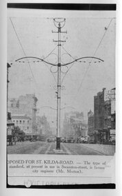 Melbourne Tram Museum
Photograph - Black and White - Swanston Street centre poles - Newspaper photo, Proposed for St Kilda Road, 1923-24
Image shows a centre of the road pole used to extend the electric tram in Swanston St from Queensberry St to Little Lonsdale St. Was proposed to be used in the conversion of cable to electric trams in St Kilda Road, but was not adopted. William St had a similar type of pole but these were removed when they became a traffic hazard.Shows design of centre poles that support overhead electric wires. Swanston Street electric trams centre poles - Newspaper photo. MMTB Swanston Street looking south from Little Lonsdale Street Melbourne, about 1923-24.tramways, trams, swanston street, centre poles, st kilda road -
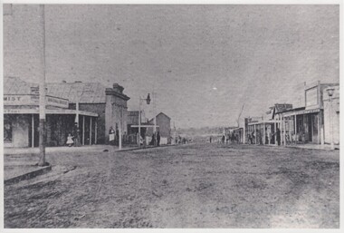
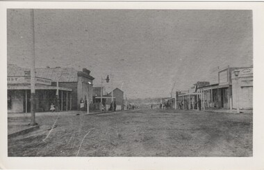 Rutherglen Historical Society
Image, c1870
Very early photograph of Main Street, Rutherglen, probably toward the end of the gold rush. The Oriental Bank shown on the right of the photo closed around 1870.Black and white photograph of Main Street looking east.main street, rutherglen, oriental bank -
 Eltham District Historical Society Inc
Slide - Photograph, Bells Hill Road, Research, c.May 1988
Looking north along Bells Hill Road at intersection with Kybrolyde Ct, Research, May 198835mm colour positive transparency (1 of 36) Mount - Kodak KodachromeProcess Date MAY 88Mbells hill road, infrastructure, kybrolyde ct, research (vic.), roads -
 Eltham District Historical Society Inc
Slide - Photograph, Bells Hill Road, Research, c.May 1988
Looking north along Bells Hill Road at intersection with Kybrolyde Ct, Research, May 198835mm colour positive transparency (` of 36) Mount - Kodak KodachromeProcess Date MAY 88Mbells hill road, infrastructure, kybrolyde ct, research (vic.), roads -
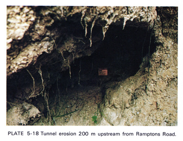 Eltham District Historical Society Inc
Work on paper (Sub-Item) - Photograph, Tunnel erosion 220 m upstream from Ramptons Road
Colour photograph of tunnel erosion 220 metres upstream from Ramptons Road, Eltham North eltham, erosion, eltham north, drain -
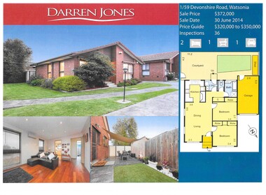 Greensborough Historical Society
Advertising leaflet, Darren Jones Real Estate, 1/59 Devonshire Road Watsonia
Sold notice for 1/59 Devonshire Road Watsonia. Sold 30 June 2014 for $372,0001 p. leaflet, printed in colour. Includes floor plandevonshire road watsonia -
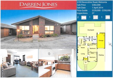 Greensborough Historical Society
Advertising leaflet, Darren Jones Real Estate, 3/59 Devonshire Road Watsonia, 2014
Sold notice for 3/59 Devonshire Road Watsonia, sold 1 April 2014 for $$382,0001 p. leaflet, printed in colour, includes floor plandevonshire road watsonia -
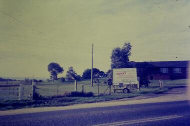 Greensborough Historical Society
Slide - Photograph, John Ramsdale, Gorge Road sign: Slide 55, 1990s
Photograph shows house with anti-Plenty Gorge Park sign, Gorge Road South MorangPart of the John Ramsdale collection of slides and audio visual material.Colour photograph scanned from slide.No maker's marks. No caption on slide.plenty gorge, plenty gorge metropolitan park, melbourne and metropolitan board of works -
 Greensborough Historical Society
Photograph - Digital Image, Chapel corner Yallambie Road and Greensborough Highway 1950s, 1950s
Black and white photograph of an old chapel that stood on the corner of Yallambie Road and Greensborough Highway in the 1950sThis chapel has been demolished.Digital copy of black and white photographyallambie road watsonia, greensborough road watsonia -
 Greensborough Historical Society
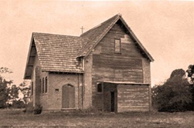
Article and Photograph, 3 St Helena Road Greensborough, 2017_
Information and photos of the house at 3 St Helena Road Greensborough, for sale in 2017, built in the 1920s.This photograph and text was copied from a Facebook site. Members are people who lived in the Greensborough area and share their reminiscences of the area with others. The site is administered by a GHS member but is not officially affiliated with the Society. Any information is the opinion of the contributor. Article and photograph sourced from social media.st helena road greensborough, greensborough houses -
 Greensborough Historical Society
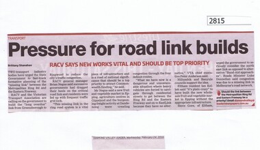
Newspaper Clipping, Diamond Valley Leader, Pressure for road link builds, 24/02/2016
RACV reports that the missing link between the Metropolitan Ring Road and Eastern Freeway should be a priority.News clipping, black text.eastern freeway, east west link project, metropolitan ring road -
 Greensborough Historical Society
Photograph, Noel Withers, 113 Greenhills Road, 1990s
Photograph of 113 Greenhill Road 1990s; former pool hall, relocated to this site, now demolished.Colour photographgreenhills road greensborough -
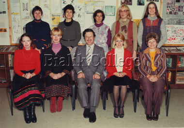 Bialik College
Photograph, Staff, Auburn Road campus, 1980, 1980
Auburn Road campus staff, 1980. Please contact [email protected] to request access to this record.auburn road, 1980s -
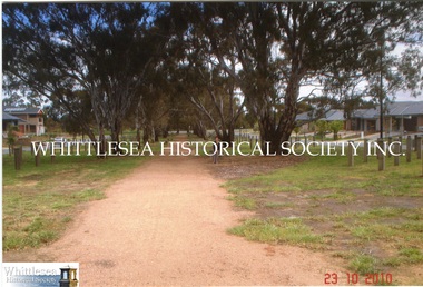 Whittlesea Historical Society Inc.
Photograph, Gwen Hawke, Road through to Wilton Vale, 2010
2 photographs showing the road through to Wilton Vale at Mernda where the original homestead stood.2 colour photographs.mernda, wilton vale mernda, rosyln wilson, smith family -
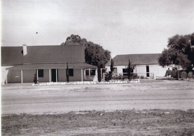 Stawell Historical Society Inc
Photograph, Salinger's House in Great Western with front on view from road shows Winery and Shed 1959
Salinger's House Great Western. Front on View from road shows Winery and Shed. 1959stawell -
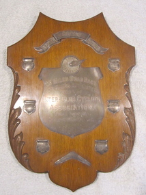 Geelong Cycling Club
Shield, 1918
Shield awarded to winners of Barnett Glass 25 Mile Road Race 1918. Shield put out by the Barnet Glass Company. After winning the shield for 3 years in a row, the recipient club was awarded the shield. This was the Geelong West Cycling Club.Wooden Shield with nickel plated plaques inscribed with winners names of Geelong Cycling Club 25 mile road race from 1918-1923"BARNETT GLASS SHIELD/ 25 MILES ROAD RACE/FOR CLUBS AFFILIATED/WITH THE/INTER CLUB CYCLING/ASSOCIATIO/FINAL WON BY GEELONG WEST CYCLING/CLUBgeelong cycling club; geelong west cycling club; shield; h.a. boyle; w. costello; f. king; norm hisham; jim holden; s. wells; barnett glass shield; 25 mile road race; 1918; -
![Electric tramway construction in Riversdale Road [Surrey Hills]](/media/collectors/550653872162f11fb04854aa/items/661deb37344c8682d4fa54e0/item-media/661dec13344c8682d4fa98bd/item-fit-380x285.jpg) Kew Historical Society Inc
Kew Historical Society IncPhotograph - Electric tramway construction in Riversdale Road [Surrey Hills], E.J. Dower, 1916
Contextual or historic information One of a series of photographs, taken by Edgar James Dower in the second decade of the twentieth century. Born and raised in Olinda, his family later moved to Surrey Hills. He worked as an adult as a clerk in the city office of the Metropolitan Gas Company, and in his role as a 'collector', he was able to photograph scenes including the construction of tramlines and associated buildings in Kew, Hawthorn, Camberwell and Surrey Hills. Later he established a real estate agency with his brother - the E.J. Dower Real Estate Agency, Dandenong Office.The image is an historically significant record of the development of transport infrastructure which was used to connect Victorians in the first two decades of the twentieth century. This development resulted from increases in population and the consequent extension of Melbourne's suburbs. The photographs, both individually and collectively, richly detail the labour of workers and the tools and machinery used to create and extend Melbourne's tram network in the years preceding and during World War 1.Digital copy of an original mounted photograph of construction of the electric tramline in Riversdale Road, Surrey Hills.Annotated verso: "Showing the commencement of preparing for electric trams in Riversdale Road / Taken from the corner of Union Road, note Essex road on right with picket fencing"theme --- travelling by tram, theme -- connecting victorians by transport and communications, trams -- boroondara (vic.), tramlines -- surrey hills -
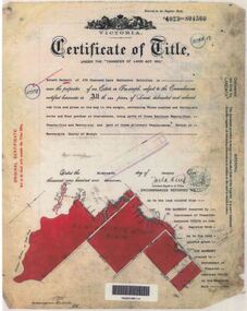 Ringwood and District Historical Society
Document - Research Folder, Helm Family, Oban Road, Ringwood, Victoria - 1917-2008
Transcription of conversation with Alma and Kelly Helm by Richard Carter (Past President of Ringwood Historical Society) and Larraine Haslam on 18 July 2008 detailing family history. Certificates of title of land between Oban Road and Mullum Mullum Creek. Six and a half acres sold to the Helm Family in 1917. Includes Certificate of Title Vol 5311 Fol 1062052 Carolyn Mary Glynn dated 27 April 1927. Certificate of Title Vol 4023 Fol 804560 Robert Beckett dated 19th January 1917. Plans of Subdivision including Oban Road, Barnsdale Way, Loughies Track, 1997. Certificate of Title Vol 4029 Fol 805702 Ellen Elizabeth Helm dated 8th February 1917. Transfer of Land (2093031) payment to James William Dartnell by Alma Mary Helm and Elsie May Helm of Oban Road, Ringwood North - 13th August, 1947. -
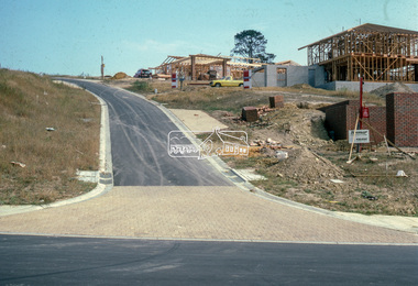 Eltham District Historical Society Inc
Slide - Photograph, Road infrastucture, new housing development, most likely Templestowe, c.Mar. 1985
Eltham Shire Council officers would benchmark road infrastructure in surrounding local government areas. In this case, the street is most likely a private street scheme in a new housing development in what is present-day Manningham City Council. Areas of interest in the phioto are the roll over concrete kerbs, brick paving at road entrace and drainage.35mm colour positive transparency (1 of 15) Mount - Kodak Kodachrome Cardinfrastructure, roads, city of manningham, footpaths and gutters, housing estates, unidentified, templestowe -
![Photograph - Digital Image, Ray White Greensborough, 3 St Helena Road Greensborough [exterior], 2017_](/media/collectors/4f729f5697f83e03086015b8/items/5d3bfe1621ea6715d01b253f/item-media/5d3bfe3821ea6715d01b5585/item-fit-380x285.jpg) Greensborough Historical Society
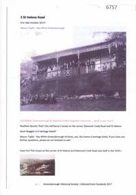
Greensborough Historical SocietyPhotograph - Digital Image, Ray White Greensborough, 3 St Helena Road Greensborough [exterior], 2017_
Exterior photographs of the house at 3 St Helena Road Greensborough (corner Diamond Creek Road). The house was built in 1920. These photographs are from the Ray White sales brochure 2017. The 4 bedroom property sold in December 2017 for $900,000; previous sales: April 2009, $600,000; June 1981, $36,500; June 1976, $32,500. Digital copy of 5 colour photographs, possibly taken from a drone.st helena road greensborough, diamond creek road greensborough -
 Greensborough Historical Society
Map, Melbourne and Metropolitan Board of Works. Survey Division, MMBW, Yarra 2500 / 15.24. Diamond Creek, Grassy Flat Road, 1978_02
Melbourne and Metropolitan Board of Works. Yarra 2500 [base map] 15.24. Diamond Creek, Grassy Flat Road. Parish of Nillumbik 3310. Municipality of Diamond Valley 257. Prominent streets include: Everleigh Drive, Broad Gully Road and Clyde Street. Features include the Diamond Creek, Nillumbik Park and Diamond Creek Reservoir.MMBW Map in 1:2500 [scale] series. Cream parchment with green tape reinforcing on edges and punched holes on left edge.mmbw, melbourne and metropolitan board of works, diamond creek - maps, shire of diamond valley -
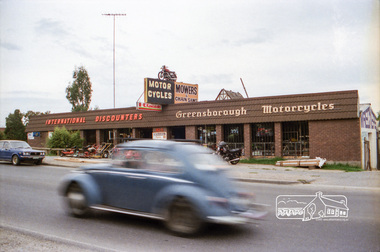 Eltham District Historical Society Inc
Negative - Photograph, Industrial development, Para Road, Briar Hill, c.1984
Views of industrial sites and shop fronts on Para Road, Briar Hill including the business 'Greensborough Motorcycles'. Para Road, Briar Hill is parallel to the Hurstbridge Railway Line. The building 'Greensborough Motorcycles' was destroyed by fire in the early 2000s. Signage on building includes: 'Greensboröugh Motorcycles', 'International Discounters', 'Motor Cycles', and 'Mowers & Chainsaws' and 'Hutchinson's'.Roll of 35mm colour negative film, 4 stripsKodak CP 100 5094briar hill, greensborough, greensborough motorcycles, hutchinson's, industry, international discounters, para road, business -
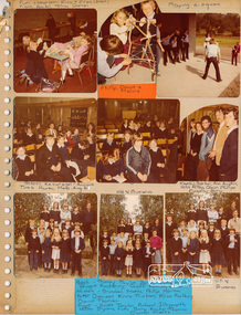 Eltham District Historical Society Inc
Photo Album page, Photo Album; Eltham Christian School, Nyora Road, Eltham, 1981-1984, 1981
Page from photo album; Eltham Christian School, Nyora Road, Eltham, 1981-1984 From series of photographs from a magnetic photo album relating to the staff, students and activities of the Eltham Christian School which operated as part of the Eltham Christian Church at Nyora Road, Eltham. See also entries for each photograph.Colour Photographs on photo album page with captionseltham christian school