Showing 5924 items
matching east road
-
 Ringwood and District Historical Society
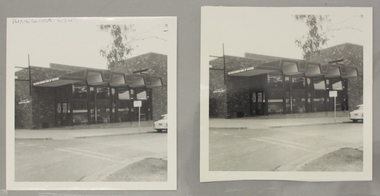
Photograph, Interior view of Ringwood North State Bank , north-east corner of Dickson's Crescent and Warrandyte Road
Interior view of the new Ringwood North State Bank premises on the north-east corner of Dickson's Crescent. Exterior view. Unknown date. Opened 25 October 1971At the corner of Dickson's Crescent and Warrandyte Road, Ringwood North. -
 Ringwood and District Historical Society
Photograph, Ringwood North State Bank , north-east corner of Dickson's Crescent and Warrandyte Road
The new Ringwood North State Bank premises on the north-east corner of Dickson's Crescent. Exterior view. Unknown date.At the corner of Dickson's Cresent and Warrandyte Road, Ringwood North. -
 Lakes Entrance Historical Society
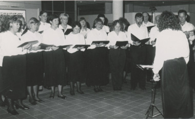
Photograph - Secondary College choir Lakes Entrance Victoria, Lakes Post Newspaper, 1/03/1992 12:00:00 AM
Led by Sue Morrissey of Secondary College performing at the launch of East Gippsland Regional Arts Officer at Shire of Tambo Palmers Road Lakes EntranceBlack and white photograph of a choir at Lakes Entrance Victoriaschools, choir -
 Lakes Entrance Historical Society
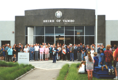
Photograph - Closing of Shire of Tambo 1994, Marie Fish, 1/11/1994 12:00:00 AM
Local Councils were amalgamated to form East Gippsland Shire Council in 1994Colour photograph of closing ceremony for Shire of Tambo showing crowd outside Shire Offices Palmer Road Lakes Entrance Victoria. Second colour photograph taken after same event shows crowd at barbeque van local government, choir -
 Ringwood and District Historical Society
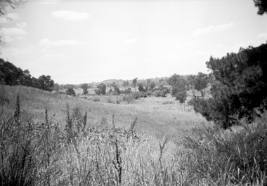
Photograph, Looking east along Dandenong Creek from very end of Heatherdale Road, Vermont South, January 1979
... Dandenong Creek from very end of Heatherdale Road." Looking east ...Written on back of photograph, "Jan. 79. Looking east along Dandenong Creek from very end of Heatherdale Road." -
 Ringwood and District Historical Society
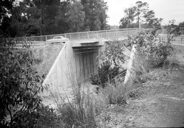
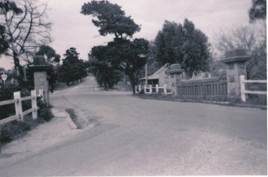
Photograph, Eastfield Road bridge just opened - looking east. Ringwood late 1978
... bridge just opened - looking east." Eastfield Road bridge just ...Written on back of photograph, "Late 1978. Eastfield Road bridge just opened - looking east." -
 Ringwood and District Historical Society
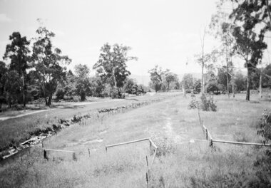
Photograph, Series of 4 photos from Wantirna Rd Bridge over Dandenong Creek and Gold Course. Ringwood January 1979
4 Black and White photographs. Written on back of photographs - all prefixed "Jan '79. :Standing on top of concrete pole at end of handrail - Wantirna Rd. bridge over Dandenong Creek -" 2674-1 / SS0357a: "looking east along creek." 2674-2 / SS0357b: "looking north-east." 2674-3 / SS0357c: "looking north." (along Wantirna Road) 2674-4 / SS0357d: "looking west over gold club." -
 Hymettus Cottage & Garden Ballarat
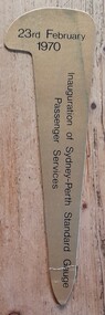
Work on paper - Bookmark, Inauguration of Sydney-Perth standard Gauge Passenger Services
Originally transport between Australia's eastern and western capitals was by coastal steamer. Rail links were by way of Melbourne and Adelaide as were most road links prior to 1970. Air travel became the most popular link until 1970 when this rail service became available.Inauguration of Sydney-Perth standard Gauge Passenger Services on 23 February 1970 was a major step in linking Australia's east and west coast by land.railways, train travel, isolation, -
 Sunbury Family History and Heritage Society Inc.
Photograph, Rosa McCall, Old Broadmeadows Township, 1949
... Sydney Road (Mickleham Road) and 2 miles east of the Broadmeadows... Sydney Road (Mickleham Road) and 2 miles east of the Broadmeadows ...The small town in the photograph is the former Broadmeadows Township (now part of Westmeadows). It was situated on the Old Sydney Road (Mickleham Road) and 2 miles east of the Broadmeadows Station. The stone bridge in the foreground spans the Moonee Ponds Creek and Fawkner Street is the road, which leads southwards to Gladstone Park and Tullamarine. The little building was a lolly shop that Mrs. Ethel Mitchell owned and ran for many years.Until 1869, before Sydney Road was finally opened, travellers on their way to Sydney would pass through the Broadmeadows Township.A copy of a non-digital black and white photograph of a road way with a bridge in the foreground leading to a small settlement. Small building with a pitched roof and a verandah is on the RHS of the image and the road leading out of the town is bordered with an avenue of pine trees.old broadmeadows township, fawkner street, moonee ponds creek, westmeadows, bridges -
 Melbourne Tram Museum
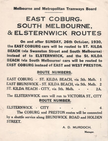
Document, Melbourne & Metropolitan Tramways Board (MMTB), "East Coburg South Melbourne & Elsternwick Routes", Oct. 1930
Notice to Passengers titled "East Coburg South Melbourne & Elsternwick Routes", advising that from 16/10/1930, rerouting of services - East Coburg to St Kilda Beach - route 1, East Brunswick - St Kilda Beach - route 2 and that Elsternwick cars route 4 will run to the City. Notes that the Coburg and Preston routes will be connected by a shuttle service along Holden St and Brunswick Road. Signed by A D Murdoch, Manager.Yields information changing of tram routes in Oct. 1930.Notice printed on quarto paper.tramways, buses, east coburg, south melbourne, elsternwick, st kilda beach, holden st, route 1, route 2, route 4, tram routes -
 Wodonga & District Historical Society Inc
Book - Spatial Vision's VICMAP BOOK 2016 - Northeast Region, Spatial Vision Innovations Pty Ltd, 2016
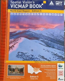
This edition of Spatial Vision's VicMap Book North East Region was published in October 2016 and provides detailed topographic maps for the region. It was used by emergency services and various agencies, including the Country Fire Authority (CFA). It covers areas including Wodonga, Albury, Wangaratta, and beyond, including national parks and recreation areas. Text on the cover states that the volume is "Trusted by and produced in partnership with: Department of Environment, Land, Water & Planning, Country Fire Authority, State Emergency Service, Parks Victoria, Victoria Police".A spiral bound volume of 409 pages including colour topographic maps and illustrations of North East Victoria. The cover features a colour photo of Razorback Ridge leading to Mount Feathertop, Hotham Heights, Victoria. It also features an index map inside the front cover, a legend, road index, and locality index.This edition of Spatial Vision's VicMap Book North East Region was published in October 2016 and provides detailed topographic maps for the region. It was used by emergency services and various agencies, including the Country Fire Authority (CFA). It covers areas including Wodonga, Albury, Wangaratta, and beyond, including national parks and recreation areas. Text on the cover states that the volume is "Trusted by and produced in partnership with: Department of Environment, Land, Water & Planning, Country Fire Authority, State Emergency Service, Parks Victoria, Victoria Police".emergency management north east victoria, state emergency service, cfa wodonga -
 Wodonga & District Historical Society Inc
Book - Spatial Vision's VICMAP BOOK 2014 - North East Region
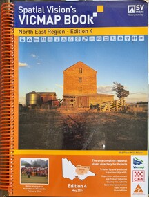
This edition of Spatial Vision's VicMap Book North East Region was published in May 2014 and provides detailed topographic maps for the region. It was used by emergency services and various agencies, including the Country Fire Authority (CFA). It covers areas including Wodonga, Albury, Wangaratta, and beyond, including national parks and recreation areas. Text on the cover states that the volume is "Trusted by and produced in partnership with: Department of Environment, Land, Water & Planning, Country Fire Authority, State Emergency Service, Parks Victoria, Victoria Police".A spiral bound volume of 409 pages including colour topographic maps and illustrations of North East Victoria. The cover features a colour photo of the old flour mill at Milawa, Victoria. It also features an index map inside the front cover, a legend, road index, and locality index.non-fictionThis edition of Spatial Vision's VicMap Book North East Region was published in May 2014 and provides detailed topographic maps for the region. It was used by emergency services and various agencies, including the Country Fire Authority (CFA). It covers areas including Wodonga, Albury, Wangaratta, and beyond, including national parks and recreation areas. Text on the cover states that the volume is "Trusted by and produced in partnership with: Department of Environment, Land, Water & Planning, Country Fire Authority, State Emergency Service, Parks Victoria, Victoria Police".emergency management north east victoria, cfa wodonga -
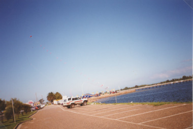 Lakes Entrance Historical Society
Photograph - Cunninghame Arm Foreshore, Vera Bennett, 1/11/1995 12:00:00 AM
Colour photograph of view from car park beside Cunninghame Arm looking east to footbridge and kite display, Lakes Entrance Victoriatownship, waterways, roads and streets -
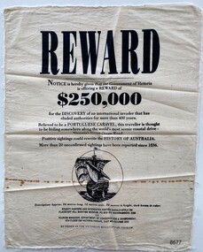 Flagstaff Hill Maritime Museum and Village
Article - Reward Poster - Portuguese Caravel, 1992
The mystery of the Portuguese Caravel, commonly known as the ‘Mahogany Ship’ is today regarded as legend and refers to an ancient wreck that is said to lie beneath the sand between Warrnambool and Port Fairy. Its location is currently unknown, but many people have searched for it through the years since the first reported sighting of an unidentified wreck in 1836. For over a century this mystery has fascinated Australians because the existence of such a vessel could throw light on the earliest phase of exploration of Eastern Australia by Europeans. The interest in the mystery was high enough for the Victorian Government to offer a reward in 1992 which was subsequently withdrawn a year later with no monies being paid.This item is historically significant because of its relationship to an ongoing mystery (the Mahogany Ship) that may throw light on the early exploration of Australia. The offering of a reward, 150+years after the first recorded sighting, by the Victorian Government points to the ongoing fascination with this subject to the Victorian people.A reward poster printed on calico. Even though the poster was created in 1992 it follows the regular structure of a reward poster from earlier times; the word REWARD in large print at the top, the amount $250,000 in bold type and an imagined drawing of the missing Portuguese Caravel.Printed text: REWARD Notice is hereby given that the Government of Victoria is offering a REWARD of $250,000 for the DISCOVERY of an international invader that has eluded authorities for more than 400 years. Believed to be a PORTUGUESE CARAVEL, this traveller is thought to be hiding somewhere along the world's most scenic coastal drive- Victoria's Great Ocean Road. Positive sightings could rewrite the HISTORY OF AUSTRALIA. More than 20 unconfirmed sightings have been reported since 1836. Description: Approx. 26 metres long, 12 metres wide, 20 metres in height, dark brown in colour. BOUNTY HUNTERS AND INTERESTED PARTIES SHOULD APPLY TO: FLAGSTAFF HILL MARITIME MUSEUM, PO BOX 574 WARRNAMBOOL 3280 OR TOURISM MANAGER, DEPARTMENT OF CONSERVATION & ENVIRONMENT, 8TH FLOOR 250 VICTORIA PARADE, EAST MELBOURNE 3002 BY ORDER OF THE VICTORIAN MINISTER FOR TOURISM. Printed image: back view of a Caravel in full sail flagstaff hill maritime museum and village, great ocean road, shipwreck coast, warrnambool, port fairy, portuguese caravel, mahogany ship, reward poster, victorian government