Showing 6060 items matching " street signs"
-
 Linton and District Historical Society Inc
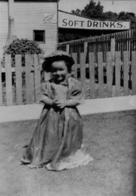
Photograph, Val Preston
... and Gillespie Street, Linton. Shop Sign Valma (Val) Preston "Val Preston ...Preston's shop was on the corner of Sussex Street and Gillespie Street, Linton.Black and white copy of original photograph showing a young girl wearing a long light coloured dress and a hat/bonnet. She is standing in front of a wooden picket fence with a sign for "SOFT DRINKS" on Preston's Shop in the background. "Val Preston" shop, sign, valma (val) preston -
 Ringwood and District Historical Society
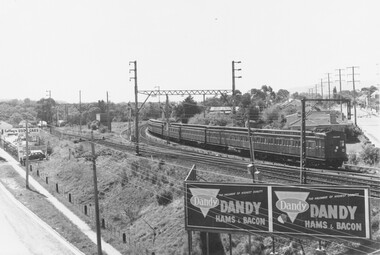
Photograph, Ringwood rail junction and Pitt Street (far right), photographed in 1960
Black and white photograph - 2 copies - In right foreground is advertising sign for Dandy Hams and Bacons. To left is sign for "Coffey's Used Cars". (2 copies)-1960 .Rail junction and Pitt St. taken from clock tower" l -
 Melbourne Tram Museum
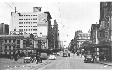
Postcard, Valentine's, "Swanston Street, Melbourne", 1930s
Valentine's postcard titled "Swanston Street, Melbourne", Number V1, looking north from south of Flinders Street. A W2 class tram with dash canopy lighting bound for East Bright on Route 64 is at the Flinders Street tram stop in Swanston Street. There are people standing in the north bound safety zone. Has Young & Jacksons Hotel advertising Protex and shows at the Tivoli Theatre. In the background is a sign for Aspro on the Nicholas Building. To the right is part of the awning leading into the Princes Bridge Railway Station.Yields information about Swanston Street during the 1940s.Postcard - printed, unused, Valentine Seriestrams, tramways, swanston st, princes bridge station, flinders street, flinders st, w2 class, route 64 -
 Melbourne Tram Museum
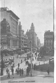
Postcard, "Swanston Street, Melbourne", 1930s
Southern Series No. 30, titled "Swanston Street, Melbourne" looking from the roof of Princes Bridge railway station, north along Swanston Street. Has at least four trams in the view, along with the long Safety Zone Stop handrails for the southbound tram stop. In the background is a sign for the Criterion Cafe & Soda Fountain.Yields information about Swanston Street during the 1930s.Postcard - printed, unused, Southern Series No. 30trams, tramways, swanston st -
 Melbourne Tram Museum
Postcard, Valentine's, "Collins Street Melbourne", 1930s
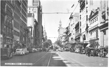
Valentine's postcard titled "Collins Street Melbourne", Number V36, looking east from Elizabeth Street. Two trams are in the far distance. In the view are signs for Kodak, Alans Music, Cooks, Centreway Arcade, The Age and The Herald.Yields information about Collins Street during the 1930s.Postcard - printed, unused, Valentine Seriestrams, tramways, collins st -
![Sign, Shire of Eltham, St Faiths Road, Shire of Eltham [street sign], 1960s](/media/collectors/4f729f5697f83e03086015b8/items/67db6caab13536720ddc4bb9/item-media/67f21a5be76666667ba86b1f/item-fit-380x285.jpg) Greensborough Historical Society
Greensborough Historical SocietySign, Shire of Eltham, St Faiths Road, Shire of Eltham [street sign], 1960s
... St Faiths Road, Shire of Eltham [street sign]... Faiths Road, Shire of Eltham [street sign] Sign Sign Shire ...Road sign pre 1994 of St Faiths Road, Montmorency, formerly in the Shire of Eltham. This early sign does not have the Shire of Eltham 'branding' of later signs. Following the redistribution of local government areas in 1994, St Faiths Road was allocated to the City of Banyule.Double Sided Metal sign, white with black writing shire of eltham, road sign, st faiths road montmorency -
 Wangaratta RSL Sub Branch
Work on paper - Envelope Art
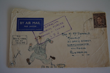
One of several illustrated envelopes, without letter, sketched by soldier/s during the second world war and sent to Mrs McDonald of Grey Street Wangaratta.Victoria's 2/24th Infantry Battalion was raised in Wangaratta in July 1940. They were welcomed with open arms by the local community as they rapidly built up their numbers. The people of Wangaratta adopted the Battalion and they became known as "Wangaratta's Own" because of the time the battalion spent in the town during its formative period prior to deployment overseas. Many of the soldiers maintained life long friendships with the people of Wangaratta. Even though the Battation was disbanded in 1946 members and their families return each year, in November, for a commemorative service at the 2/24th Battalion Memorial Wall at the Wangaratta Cemetery.Cream paper envelope with sketch of male figure running toward signTop left - AIR MAIL Top right - postage stamp Centre - AIF Censor stamp Right side Mrs M McDonald "Monald" 32 Grey Street Wangaratta Victoria Australia Left side "Beer Issue on at 1900hrs" Bottom "Boy OH Boy I'll be in on that" ww2, envelope art -
 Bendigo Historical Society Inc.
Document - NEW CHUM LINE OF REEF MUNGO GROUP EAGLEHAWK
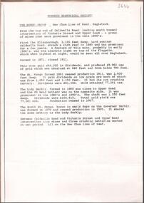
Two page document detailing the Mungo Group of Mines along the New Chum line of reef, Eaglehawk. The mines described are: Ellenborough, 2100 feet deep St Mungo, 2,600 feet deep The Lady Barkly, 1,350 feet deep, close to Upper Road with a 40 head battery on the other side. South St Mungo, known as the Governor Barkly in the earlier days. Small map on second page shows the location of the Sadowa shaft, St. Mungo shaft and the Lady Barkly shaft. Victoria Street and Upper Road marked on the map. 'Between Caldwells Road and Victoria Street and Upper Road intersection, nine mines and three crushing batteries worked at one period. All on the New Chum line of reef.' Not signed but most probably written by Albert Richardson.bendigo, mining, mungo group of mines, eaglehawk -
 Eltham District Historical Society Inc
Document - Property Binder, 66 Susan Street, Eltham
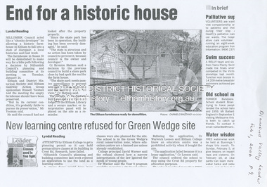
Newspaper clipping (photocopy/digital only): End for a historic house, Lyndal Reading, Diamond Valley Leader, February 1, 2006, p9Alistair Knox Park, Eltham, Eltham Skate Park A small cream cottage with green roof. The farmhouse built in the late 1800s by the Crozier Family. Subsequently owned by the Hill Family. Purchased in the early 1960s and by 1965 the property was owned by the Shire of Eltham. Employees of the Shire lived in the house. Susan Street originally ran all the way north of Bridge Street to the bend where it turned to the left into Brisbane Street. Today that section of Susan Street has been renamed as an extension of Brisbane Street. In 2006 the Shire of Nillumbik demolished the house which had been subject to extensive vandalism. In accordance with heritage advice and a permit condition a sign was placed on the site outlining the history of the building. This was installed and remained in place till about 2016 when it was removed. The land adjoins Alistair Knox Park. By 2010 the Eltham Skate Park was developed. In 2022 a major renovation and extension took place. Sources: EDHS Newsletter No 171 November 2006alistair knox park, eltham, eltham skate park, house, susan street -
 Stawell Historical Society Inc
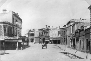
Photograph, Main Street Stawell looking West from Layzell Street c1900's
... Drapers sign visible. Patrick Street runs off to the left... Drapers sign visible. Patrick Street runs off to the left ...Main St. Scenes looking West from Layzell St. J Chadwick Drapers sign visible. Patrick Street runs off to the left of the photo. Horse drawn buggy in centre of roadway. Circa 1900's. George Whight's shop is visible on right centre.stawell businesses streetscape -
![Sign, Shire of Eltham, St Faiths Road, Shire of Eltham [street sign], 1970c](/media/collectors/4f729f5697f83e03086015b8/items/67db7068b13536720ddd1c08/item-media/67f21867e76666667ba84bc9/item-fit-380x285.jpg) Greensborough Historical Society
Greensborough Historical SocietySign, Shire of Eltham, St Faiths Road, Shire of Eltham [street sign], 1970c
... St Faiths Road, Shire of Eltham [street sign]... of Eltham Logo and Name St Faiths Road, Shire of Eltham [street sign ...Road sign pre 1994 of St Faiths Road, Montmorency, formerly in the Shire of Eltham. Following the redistribution of local government areas in 1994, St Faiths Road was allocated to the City of Banyule.Double Sided Metal sign painted yellow with green writing and Shire of Eltham Logo and Nameshire of eltham, sign, st faiths road montmorency -
 Melbourne Tram Museum
Photograph - Bourke St looking east from near Queen Street, c1900
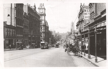
Photograph shows a scene looking east along Bourke St from near Queen St. Has a number of cable trams in the view, one sign written Clifton Hill, along with several horse-drawn carts. Has signs for T Warburton, W T Henley's Telegraph works, Bryants Hotel, and the Metropolitan Hotel. The GPO is in the background.Yields information about cable trams in Bourke St and the buildings near Elizabeth St c1900.Black and white photograph with notes on the rear. Has the number "64" in pencil in top right-hand corner and "H2172".tramways, cable trams, bourke st -
 Northern District School of Nursing. Managed by Bendigo Historical Society Inc.
Sign - Basic Aim of the Northern District School of Nursing
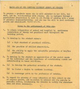
The Northern District School of Nursing opened in 1950 in to address the issues around nurse recruitment, training and education that had previously been hospital based. The residential school was to provide theoretical and in-house education and practical training over three years. The students would also receive practical hands-on training in the wards of associated hospitals. The Northern District School of Nursing operated from Lister House, Rowan Street, Bendigo. It was the first independent school of nursing in Victoria and continued until it closed in 1989. The book "The First of its Kind" was published in 2015. Printed in Bendigo by "Bendigo Modern Press". Memories compiled by Peter Rosewall; who attended the last NDSN school PTS 108 between 1986 - 89.A small laminated wall sign on fawn paper with black typed font. This sign dates to the 1950s and outlines the basic aim of the Northern District School of Nursing as well as five means to the achievement of the aim. memoir, nursing, at lister house. -
 Linton and District Historical Society Inc
Photograph, G. A. Blacksmith Engineer Building, Sussex Street, Linton, 1986
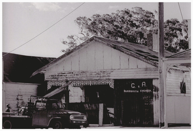
'G. A. Blacksmith Engineer' building in Sussex Street, Linton (formerly Nelson Undertaker's building), prior to restoration 1986. After restoration the former Nelson Undertaker's building became the Linton & District Historical Society's resource centre.Black and white photograph taken just prior to the building undergoing restoration in 1986. Photograph shows somewhat dilapidated building with a truck parked outside. A sign, "G. A. / Blacksmith Engineer" is painted on the front wall. In pencil on back of photograph: " Linton - Nelsons old funeral parlor just prior to restoration by L & D H S 1986".buildings, nelson undertakers, g. a. blacksmith engineer -
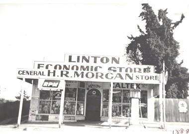 Linton and District Historical Society Inc
Photograph, H. R. Morgan General Store, Linton : Linton Economic Store
The store is understood to have been first owned by the Treloar and Nicholls families before being purchased by J. H. Morgan (father of H. R.. Morgan) in the early 1900s.Black and white copy of original photograph which shows the general store run by three generations of the Morgan family when it was being managed by H. R. Morgan (between 1930 and 1956). The photograph shows a store with large windows, a square parapet, and a verandah which is supported by four posts. A petrol bowser is outside the store near the road on the right of the photo. A sign on the parapet reads 'LINTON ECONOMIC STORE', and a sign across the verandah reads 'H.R. MORGAN GENERAL STORE'.linton economic store, h. r. (harold robert) morgan, shops, sussex street linton -
 Canterbury History Group
Photograph - Street view of the position of the bronze footpath plaque at the Canterbury Road and Maling Road junction, Jan Pigot, 2004
Coloured photograph of thes treet view of the position of the bronze footpath plaque at the Canterbury Road and Maling Road junction.canterbury, maling road, shops, signs, plaques -
Canterbury History Group
Photograph - Photograph of the blue enamel plaque on the pillar at the former Drapery at 241 Canterbury Canterbury, Jan Pigot, 2004
Coloured photograph of the street view of the blue enamel plaque on the pillar at the former Drapery at 241 Canterbury Canterbury.canterbury, canterbury road, shops, signs, plaques -
Canterbury History Group
Photograph - Street view of the 2 plaques at 245 and 241 Canterbury Road, Canterbury, Jan Pigot, 2004
Coloured photograph of the street view of the 2 blue enamel plaques at 245 and 241 Canterbury Road, Canterburycanterbury, canterbury road, shops, signs, plaques -
Canterbury History Group
Photograph - Street view of the former Maling Road Theatre bronze plaque, Jan Pigot, 2004
Coloured photograph of the street view of the former Maling Road Theatre bronze plaque.canterbury, maling road, shops, signs, plaques -
Canterbury History Group
Photograph - Street view of shops around No. 175 Canterbury Road, Jan Pigot, 1994
Coloured photograph of the street view of shops around No. 175 Canterbury Roadcanterbury, canterbury road, shops, signs -
Canterbury History Group
Photograph - Street view of shop No. 104 Maling Road, Jan Pigot, 27/03/1993 12:00:00 AM
Coloured Photograph of the street view of the Canterbury Authorised Newsagent at No. 104 Maling Road.canterbury, maling road, shops, signs -
Canterbury History Group
Photograph - Street view of shop No. 116 Maling Road, Jan Pigot, 1994
Coloured photograph of Milton's Jewellery shop at No. 116 Maling Roadcanterbury, maling road, shops, signs -
Canterbury History Group
Photograph - Streetscape of the shop No. 103 Maling Road, Jan Pigot, 27/03/1993 12:00:00 AM
Coloured photograph of the street view of Time For Tea gift shop at No. 103 Maling Roadcanterbury, maling road, shops, streetscapes, signs -
Canterbury History Group
Photograph - Foundation stone of St. Paul's Anglican Church, Church Street, Canterbury, Jan Pigot, 1994
Coloured photograph of Foundation stone of St. Paul's Anglican Church, Church Street, Canterburycanterbury, maling road, churches, signs -
Canterbury History Group
Photograph - Street view of Carnell's at 175 Canterbury Road, Canterbury, Jan Pigot, 2004
Coloured photograph of street view of Carnell's at 175 Canterbury Road, Canterbury. The enamel plaque is visible on the pillar between the 2 shops.canterbury, canterbury road, shops, signs, plaques -
Canterbury History Group
Photograph - Bronze plaque in the ground at the corner of Maling Road and Bryson Street, Jan Pigot, 1994
Coloured photograph of Bronze plaque in the ground at the corner of Maling Road and Bryson Streetcanterbury, maling road, signs -
Canterbury History Group
Photograph - Shop No. 94 maling Road on the east corner of Maling Road and Bryson Street, Jan Pigot, 27/03/1993 12:00:00 AM
Coloured photograph of pharmacy shop No. 94 on the corner of Maling Road and Bryson Street.canterbury, maling road, shops, paving, trees, signs -
Canterbury History Group
Photograph - Front street view of business at No. 141 Maling Road, Jan Pigot, 27/03/1993 12:00:00 AM
Coloured photograph of the front street view of business at No. 141 Maling Road. Former Dentist Dr. Alan Williams worked herecanterbury, maling road, shops, signs -
Canterbury History Group
Photograph - Street view of shop at No. 94 Maling Road, Jan Pigot, 1994
Coloured photograph of the street view of the Pharmacy on the corner of Maling Road and Bryson Street at No. 94 Maling Roadcanterbury, maling road, shops, signs -
Canterbury History Group
Photograph - Street view of the position of the bronze plaque in the foot path for the former State Savings Bank of Victoria at 121 Maling Road, Canterbury, Jan Pigot, 2004
Coloured photograph of the street view of the position of the bronze plaque in the foot path for the former State Savings Bank of Victoria at 121 Maling Road, Canterbury.canterbury, maling road, shops, signs, plaques