Showing 17878 items
matching shows
-
 Melbourne Tram Museum
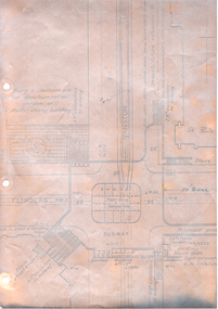
Drawing - Swanston St underground tramway at Flinders St, Melbourne & Metropolitan Tramways Board (MMTB), mid 1960s
Drawing shows the proposed layout of the Swanston St underground tram line at Flinders St. Shows the tram stop, the layout of the access to the stop, Flinders St and Princes Bridge stations, the demolition of Young and Jacksons Hotel, a railway booking office. This was part of a project that was for undergrounding of a number of tram lines in Melbourne during the early to mid 1960s. Yields information about the proposed undergrounding of the Swanston St tram line at Flinders St.Foolscap photocopied sheet on heat sensitive paper with four punched holes on the side.tramways, underground tramways, swanston st, proposed works, flinders st station -
 Bendigo Historical Society Inc.
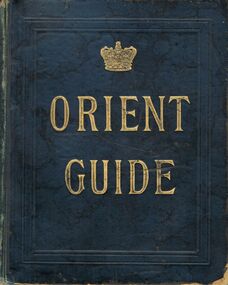
Book - BOOK: ORIENT GUIDE ORIENT LINE OF ROYAL MAIL STEAMSHIPS
Green coloured hardbound Book / gold lettering -Orient Guide /-front and back inside covers show - Orient line of Royal Mail Steamships Henry Jones & co Agents for Orient Line , View Point , Sandhurst , Orient Line of Royal Mail Steamships' / Title page shows 'Orient Line Guide -Chapters for Travellers by sea and land , Illustrated . The third Edition, Re- written, with maps and plans. Edited for the Managers of the Line by W.J.Loftie, B.A., F.S.A., Author of 'A History of London ‘, 'Windsor ' 'Authorised guide to the Tower 'Etc. Etc. . . . Price 2/6 London : Sampson Low , Marston , Searle , & Rivington , Limited , St. Dunstan's House , Fetter lane , Edward Stanford , 26 , & 27 Cockspur St . S.W. 1888 Entered at Stationers Hall / this page also has a rubber stamp ' Eaglehawk Public Library / first page of chapter 1 shows 'With compliments of Henry Jones & Co , View point Sandhurst / contents include a list of Orient Line Steam ships , illustrations and ships 'plans ,maps , advertsorganization, business, -orient guide / orient line of royal mail steamships henry jones & co agents for orient line , view point , sandhurst , orient line of royal mail steamships' / w.j.loftie , b.a., f.s.a. , author of 'a history of london ' / sampson low , marston , searle , & rivington , limited , st. dunstan's house , fetter lane , edward stanford , 26 , & 27 cockspur st . s.w. 1888 entered at stationers hall /henry jones & co , view point sandhurst -
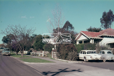
 Melbourne Tram Museum
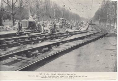
Photograph - Illustration/s, Melbourne & Metropolitan Tramways Board (MMTB), 1950's?
Series of three Black and white Illustrations, reproduction of a MMTB report of photographs of the reconstruction of St Kilda Road, near City Road c1955. .1 Photo titled "St Kilda Road Reconstruction Pouring concrete on last section near City Road, looking south. Temporary (double) track on right. Shows a large group of men working, including some looking at the camera. Shows the construction of temporary track. Has a wide bodied W outbound. Has the Shrine of Remembrance in the far distance. .2 - showing "New Work and some temporary work" - shows the "shoo fly" temporary track link between the side temporary track and the new track. Has a tram in the far distance. Photograph taken near Victoria Barracks. .3 - "General view from just south of City Road, looking south - temporary (double) track in foreground. Similar to .l Originally reproduced in a possibly an MMTB report - not a mid 50's annual. Entry revised 7/7/2017 following addition of items .2 and .3trams, tramways, mmtb, st kilda rd, trackwork, reconstruction -
 Melbourne Tram Museum
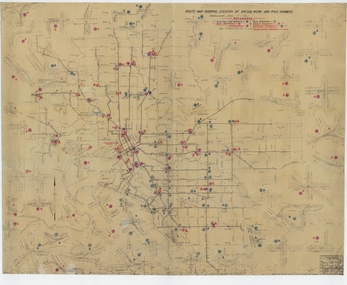
Drawing, Melbourne & Metropolitan Tramways Board (MMTB), "Route Map showing location of special work and pole numbers" "substations", late 1942
Map of the system shown at two inches = 1 mile. Drawing No. P5799. Shows crossovers, track layouts at junctions, signal cabins roads, railways, and stations. Originally signed by Perway Engineer - 20/12/1940, though originally drawn in 1922. The plan shows the lines to Maribyrnong Munitions works along Cordite Ave and Wests Road and the track from Moonee Ponds to Union Road, opened in July 1941, and the extension to Essendon Airport built in 1942, but not the Queen St North Essendon substation. Shows underground cables, tram and bus depot, workshop locations, and substation locations and their priority.Yields information about the MMTB substation locations in 1942.Drawing - dyeline cloth backed print - titled - "Route Map showing location of special work and pole numbers" and subtitled - "Substations". trams, tramways, mmtb, trackwork, tramways, junction, map, world war 2, substation -
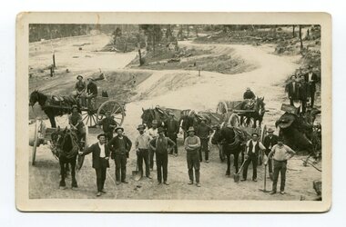 Orbost & District Historical Society
black and white photograph, late 19th - early 20th century
This photograph shows men working goldfields - possibly the battery mines at Club Terrace or near Bendoc? Clarkeville?This item is a pictorial record of the gold mining history of East Gippsland.A black / white postcard / photograph of a group of miners in the foreground with horses an wagons in the background on gold fields.gold-mining-east-gippsland -
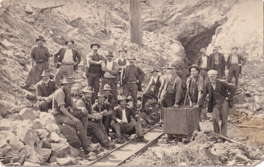 The Beechworth Burke Museum
Postcard, 1914-1916
This postcard shows a group of men standing outside of the Everton mine alongside a mining trolley sitting on tracks. The search for gold is ingrained into the history of Victoria and therefore, images like this one can reveal important information for society and technology for the date when the photograph was taken. It also shows a location where reef mining was undertaken which provides insight into the impact on the environment at a time when it was done.A sepia toned rectangular postcard printed on photographic paperpost card/correspondence address only/ Kodak Australia/1914everton mine, mining, goldrush, postcard, burke museum, black and white, photograph, mining trolley -
 Kiewa Valley Historical Society
Film Projector
This film sound projector was used to show 8mm films. The film would be projected onto a screen for viewing.This projector was owned and used by a resident of the Kiewa Valley during the 1970's.Black plastic box with a handle on the top and a lever that comes out for the reel to be attached. On the front there are 5 black 'push in' knobs and 1 red 'push in' knob. Also 2 round black rotating knobs that turn. It has 3 legs and 2 outlets at the back. Included in the box are:- 1. Booklet 'Chinon Sound 8000' Instructions. 2. 1 black reel. 3. 4 movies- 'The Blue Max'; 'Spitfire'; 'Tora Tora Tora'; and ' The Queen's Silver Jubilee Air Pageant 1977'.film. sound projector. movies. -
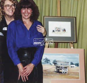 Eltham District Historical Society Inc
Photograph, Two unidentified women at an art show, c.2000
Two unidentified women, possibly at an art show run by Nillumbik Shire Council at the Eltham Community Centreart show, eltham community centre -
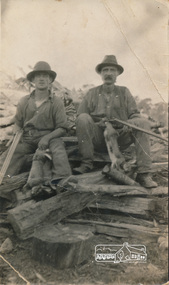 Eltham District Historical Society Inc
Photograph, Arthur Frederick Castledine (right) sitting on a wood pile towards the rear of their property, Araluen (southern end), Old Eltham Road, Lower Plenty, c.1930, 1930c
Shows the men with rifles sitting on a wood pile out hunting for rabbits around the time of the Great DepressionDigital image of original held in private collection of Joan Castledine, daughter of Sid and Polly (nee Arrowsmith) Castledine, granddaughter of Arthur Frederick Castledine.araluen, arthur frederick castledine, lower plenty, old eltham road, rabbits -
 Eltham District Historical Society Inc
Slide, Luck Street, Eltham, 25 Jul 1973
Shows the entrance to the carpark which ran through to Pryor Street. A Chrysler S series Valiant at the entrance35 mm colour positive transparency Mount - Agfacolor Service (Blue)eltham, carparks, shopping centre, streets, valiant s, luck street, houses -
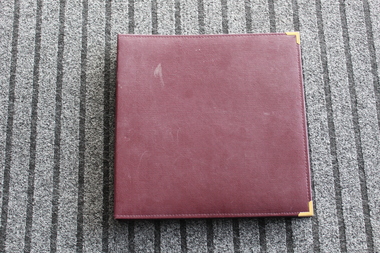 Lara RSL Sub Branch
Pre 2000 Lara R.S.L. photo album
The pictures in this album show Lara R.S.L. members and their families (past & present) observing the Remembrance day service.Many of the people shown in this album are no longer with us.Square shaped photo album, Burgundy in colour with brass corner brackets on front cover. Inside there are 288 plastic pockets for photographs.remembrance day service, lara r.s.l. photo albums. -
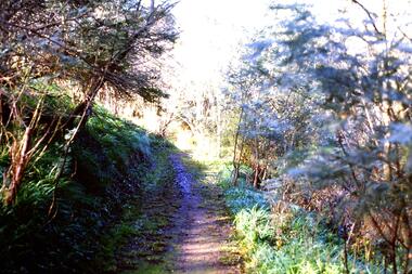 Greensborough Historical Society
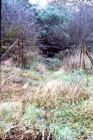
Slide - Photograph, John Ramsdale, Along Plenty River near Para Road: Slide 86, 1990s
Photograph shows a track through bushland, along the Plenty River near Para Road, possibly Montmorency.Part of the John Ramsdale collection of slides and audio visual material.Colour photograph scanned from slide.No maker's marks. No caption on slide.plenty river, para road montmorency, bushland -
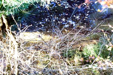
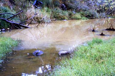 Greensborough Historical Society
Slide - Photograph, John Ramsdale, Muddy Plenty River: Slide 93, 1990s
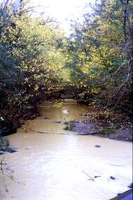
Photograph shows a muddy Plenty River with a small creek entering the river. Note the dumped car in background.Part of the John Ramsdale collection of slides and audio visual material.Colour photograph scanned from slide.No maker's marks. No caption on slide.plenty river, pollution -
 Greensborough Historical Society
Slide - Photograph, John Ramsdale, Erosion, South Morang: Slide 113, 1990s
Photograph shows a house with horse float and erosion on a poorly maintained driveway, Gorge Road South Morang. Part of the John Ramsdale collection of slides and audio visual material.Colour photograph scanned from slide.No maker's marks. No caption on slide.gorge road south morang, erosion -
 Greensborough Historical Society
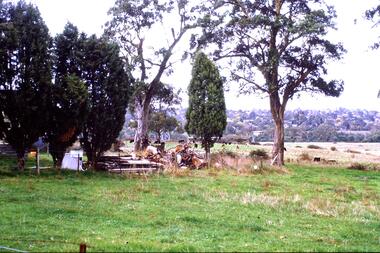
Slide - Photograph, John Ramsdale, Farmland, Lower Plenty: Slide 116, 1990s
Photograph shows a rural scene - a farmyard with stacked wood and disused farm equipment - in Lower Plenty, 1990s.Part of the John Ramsdale collection of slides and audio visual material.Colour photograph scanned from slide.No maker's marks. No caption on slide.lower plenty, farms -
 Greensborough Historical Society
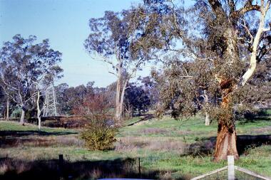
Slide - Photograph, John Ramsdale, Near the confluence of the Plenty and Yarra Rivers, Lower Plenty: Slide 118, 1990s
Photograph shows a rural scene with gumtrees and pylon. This is near the confluence of the Plenty and Yarra Rivers, Lower PlentyPart of the John Ramsdale collection of slides and audio visual material.Colour photograph scanned from slide.No maker's marks. No caption on slide.yarra river, plenty river, lower plenty -
 Greensborough Historical Society
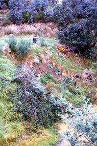
Slide - Photograph, John Ramsdale, Slumping erosion along the Plenty River: Slide 110, 1990s
Photograph shows a man standing on an embankment which is being eroded. This is slumping erosion along the Plenty River.Part of the John Ramsdale collection of slides and audio visual material.Colour photograph scanned from slide.No maker's marks. Caption on slide "Plenty"plenty river, erosion -
 Greensborough Historical Society
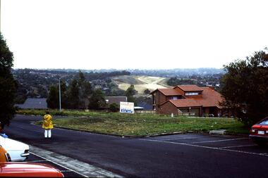
Slide - Photograph, John Ramsdale, Greensborough Bypass near Apollo Parkways: Slide 91, 1990s
Photograph shows houses in foreground and further development in background, including Greensborough Bypass near Apollo Parkways.Part of the John Ramsdale collection of slides and audio visual material.Colour photograph scanned from slide.No caption. Printed maker's mark on slide "Kodak Kodachrome Slide"greensborough bypass, apollo parkways -
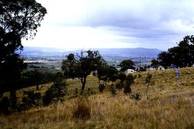
 Greensborough Historical Society
Slide - Photograph, John Ramsdale, Looking towards Bulleen from Lower Plenty; Slide 115, 1990s
Photograph shows a rural scene with gum tree and pylon, looking towards Bulleen from Lower Plenty.Part of the John Ramsdale collection of slides and audio visual material.Colour photograph scanned from slide.No caption. Printed maker's mark on slide "Kodak Kodachrome Slide"bulleen, lower plenty -
 Greensborough Historical Society
Slide - Photograph, John Ramsdale, Poorly managed farmland: Slide 121, 1990s
Photograph shows a post and wire fence with bushland beyond, and example of poorly managed farmland, thistles in foreground.Part of the John Ramsdale collection of slides and audio visual material.Colour photograph scanned from slide.No caption. Printed maker's mark on slide "Kodak Kodachrome Slide"weeds, farming -
 Greensborough Historical Society
Slide - Photograph, John Ramsdale, Rural landscape Mill Park: Slide 9
Photograph shows a rural landscape with a few buildings, possibly east of Plenty Road near Mill Park.Part of the John Ramsdale collection of slides and audio visual material.Colour photograph scanned from slide.No maker's marks. No caption on slide.mill park -
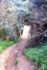 Greensborough Historical Society
Slide - Photograph, John Ramsdale, Crossing Plenty River: Slide 12, 1990s
Photograph shows erosion on a path to a footbridge over the Plenty River down from George Court Montmorency.Part of the John Ramsdale collection of slides and audio visual material.Colour photograph scanned from slide.No maker's marks. No caption on slide.plenty river, erosion, montmorency -
 Greensborough Historical Society
Slide - Photograph, John Ramsdale, Sprayed blackberries: Slide 18, 1990s
Photograph shows sprayed and dead blackberries on the bank of the Plenty River; behind factories on Para Road Montmorency.Part of the John Ramsdale collection of slides and audio visual material.Colour photograph scanned from slide.No maker's marks. No caption on slide.plenty river, weeds, blackberries, para road montmorency -
 Greensborough Historical Society
Slide - Photograph, John Ramsdale, Plenty River with European trees: Slide 24, 1990s
Photograph shows a section of the Plenty River with European trees and clay run-off from building nearby.Part of the John Ramsdale collection of slides and audio visual material.Colour photograph scanned from slide.No maker's marks. No caption on slide.plenty river, vegetation -
 Greensborough Historical Society
Slide - Photograph, John Ramsdale, Car park on Kurrak Road Yarrambat: Slide 45, 1990s
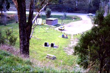
Photograph shows a park and carparking area with people sitting at picnic table, Middle Gorge Park, Yarrambat.Part of the John Ramsdale collection of slides and audio visual material.Colour photograph scanned from slide.No maker's marks. No caption on slide.middle gorge park, yarrambat, kurrak road yarrambat -
 Greensborough Historical Society
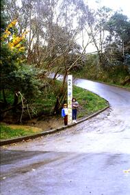
Slide - Photograph, John Ramsdale, Ford over Plenty River at Partington's Flat: Slide 52, 1990s
Photograph shows 2 children with flood height marker at the ford over Plenty River at Partington's FlatPart of the John Ramsdale collection of slides and audio visual material.Colour photograph scanned from slide.No maker's marks. No caption on slide.partingtons flat, ford over plenty river, plenty river -
 Greensborough Historical Society
Photograph - Digital Image, J. Gadsden and Co. Picnic at Greensborough 1934 - Gadsden cricket team, 1934_
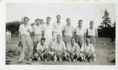
Photographs of the J. Gadsden and Co. picnic in Greensborough, in 1934. This photo shows the "Gadsden Cricket Team 1934". Gadsden's produced packing materials - originally paper and cardboard, then food cans.Digital copy of black and white photograph.On back of photo "Gadsden Cricket 1934"gadsden and co., picnics in greensborough, cricket -
 Greensborough Historical Society
Photograph - Digital Image, Plenty Bridge Hotel Lower Plenty c1920, 1920s
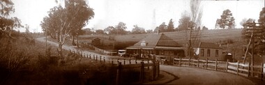
Plenty Bridge Hotel Lower Plenty, 1920s. This photograph shows the Plenty Bridge Hotel circa 1920. Digital copy of black and white photographlower plenty, plenty bridge hotel, lower plenty hotel -
 Greensborough Historical Society
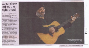
Newspaper Clipping, Diamond valley Leader, Guitar show strikes the right chord, 31/07/2019
Greensborough's Shannon Bourne is gearing up for his fifth consecutive performance at Melbourne's annual guitar show.News article 1 page, black text.greensborough, shannon bourne, melbourne guitar show -
 Greensborough Historical Society
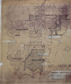
Map, City of Heidelberg: Residential Policy, 1976c
Shows residential zones 3, 4 & 5 established by Residential Policy adopted 13/12/1976Black print on waxed paper. Scale: 20 chs to 1 inchG M Hutchins. $1city of heidelberg, heidelberg