Showing 25205 items
matching north
-
 National Vietnam Veterans Museum (NVVM)
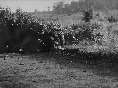
Photograph, Gibbons, Denis, Clearing Road Block
Denis Gibbons (1937 – 2011) Trained with the Australian Army, before travelling to Vietnam in January 1966, Denis stayed with the 1st Australian Task Force in Nui Dat working as a photographer. For almost five years Gibbons toured with nine Australian infantry battalions, posting compelling war images from within many combat zones before being flown out in late November 1970 after sustaining injuries. The images held within the National Vietnam Veterans Museum make up the Gibbons Collection.A black and white photograph of an Australian Engineers crawls around a road block constructed by VietCong across the National Highway North West of the Province capital Baria. Once the charges and mines were isolated, the Engineer cleared the obstruction and reopened the roadphotograph, nva/vc, engineers, baria, gibbons collection catalogue, viet cong, national highway, province, land mines, denis gibbons -
 Uniting Church Archives - Synod of Victoria
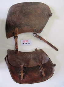
Saddlebag
This small saddle bag was carried on the off-side (right hand side) of the saddle. Nyah West is a town in Victoria, near the Murray River. It is near the Murray Valley Highway, 371 kilometres north-west of Melbourne and 27 kilometres north-west of Swan Hill.Dark brown leather single small saddlebag. The bag is secured with two buckles. -
 Flagstaff Hill Maritime Museum and Village
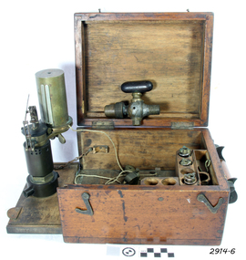
Engine Dynamometer, c.1890’s
The steam engine indicator, or dynamometer, is an instrument used on a steam engine (such as that of a vessel or train) to measure and record the change in the pressures of the engine’s cylinders during their operating cycle. The engineer would use it to identify problems or defects such as bad valve settings or constricted steam pipes. It could indicate the difference in efficiency caused by adjustments made to the engine, being able to instantly measure the variation of pressure from the engine stroke at any given time. This force of power would be registered by a pencil, fitted to the adjustable arm, which would trace a line on paper wound around the cylinder. The recorded information could be used in conjunction with mathematical tables. This particular instrument was made by T.S. Mc Innes, one of the better manufacturers of engine indicators. Mc Innes engine indicators were still being used in the mid 1900’s. This specific instrument was used by Mark Forsythe of North Berwial, Scotland and late of Ararat, Victoria when he was chief engineer on the “SS Talawena” in 1892. The Port of Warrnambool, in Victoria, harboured steam ships that carried both passengers and cargo along the south west coast in the late 1800’s and into the 1900’s. The engineer of a steam ship was responsible for reaching and maintaining the optimum level of steam energy to serve the locomotion and efficiency of the steam ship. The engineer would use a steam engine indicator to measure and record information to achieve this purpose. Engine Dynamometer or Steam Engine Indicator in square, fitted oak case. This brass instrument is used to measure and record steam pressure for setting up and adjusting valves on a steam engine. It has an oscillating recording drum with vertical, silver clip attached for holding paper in place around the drum. The drum oscillates left to right. There is a pulley attached to a length of cord, which is attached to the drum. Beside the drum is a fine metal arm, vertically adjustable, small hole in the end to hold a pencil. Inscription stamped into bracket of the arm. The engine indicator is mounted on a hinged side of the case that swings out ready for use. Attached chains prevent the side from opening past vertical. There is storage for other accessories and an empty compartment in the base (where a scale or ruler may have been located). The case has a collapsible wooden handle, brass hinges and two brass, hook-shaped catches. There is a code stamped inside the lid. It contains a brass, ‘T’ shaped steam-cock (or stop cock) with two open ends made of metal pipe with different sized threads. (Turning the handle on top opens and closes the space in the pipe and would close off the flow of steam from one end to the other.) Also inside the case are three different spiral springs, each with a threaded nut on the end that has a threaded hole inside it. Used by Mr Mark Forsythe when chief engineer on the SS Talawena in 1892 “T.S. MC INNES PATENT” and “522 _ _” (last 2 digits are unreadable) pressed into the arm of the brass indicator. “[ ] X ’ stamped inside the lid of the case. The 3 springs all have a number stamped into them: (1) “32” and “12” (2) “12” and “16” [above] “12” (3) “64” and “150” Card that came with instrument “This instrument was used by Mark Forsythe of North Berwial Scotland and late of Ararat, Victoria when chief engineer on the SS Talawena in 1892" dynamometer, steam engine indicator, t.s. mcinnes, glasgow, dobbie mcinnes, port of warrnambool, warrnambool, flagstaff hill, flagstaff hill maritime museum, flagstaff hill maritime village, maritime museum, shipwreck coast, great ocean road -
 Eltham District Historical Society Inc
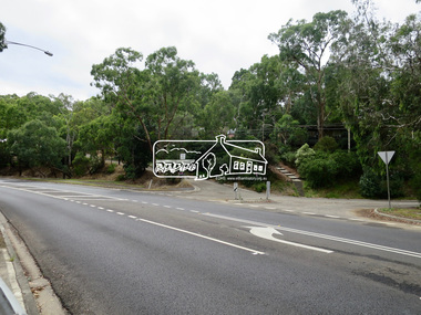
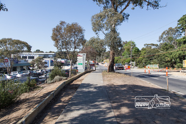
Photograph, Jim Connor, Main Road, Eltham, 14 Jan 2017
Eltham Gateway, Intersection of Antoinette Boulevard at Main Road looking northTomorrow's history documented todayeltham, jim connor collection, main road, eltham gateway, antoinette boulevard -
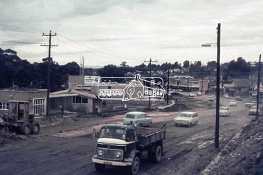 Eltham District Historical Society Inc
Photograph, Roadworks, Main Road widening, Eltham, 15 July 1968, 1968
Looking north from near Dudley Street towards shopping strip35mm Colour positive transparency Mount - Agfacolor Service (Blue stepped)arthur street, bp service station, dudley street, duplication, eltham, eltham fire brigade, eltham war memorial, fire station, main road, road construction, war memorial gates -
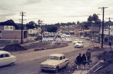 Eltham District Historical Society Inc
Photograph, Roadworks, Main Road widening, Eltham, 15 July 1968, 1968
Looking north from near Dudley Street towards shopping strip35mm Colour positive transparency Mount - Agfacolor Service (Blue stepped)bp service station, duplication, eltham, eltham fire brigade, fire station, main road, road construction -
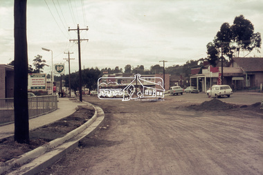 Eltham District Historical Society Inc
Photograph, Roadworks, Main Road widening, Eltham, c.15 July 1968, 1968
Looking north from near Dudley Street towards shopping strip35mm Colour positive transparency Mount - Agfacolor Service (Blue stepped)arthur street, bp service station, duplication, eltham, eltham fire brigade, fire station, main road, road construction -
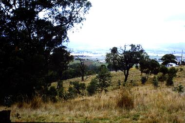 Greensborough Historical Society
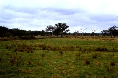
Slide - Photograph, John Ramsdale, Mt Disappointment: Slide 127, 1990s
Photograph shows a rural view from Mount Disappointment, north of Whittlesea.Part of the John Ramsdale collection of slides and audio visual material.Colour photograph scanned from slide.No maker's marks. No caption on slide.mt disappointment, mount disappointment, whittlesea -
 Greensborough Historical Society
Slide - Photograph, John Ramsdale, Flood plain of the Plenty River: Slide 90, 1990s
Photograph shows farmland on the flood plain of the Plenty River, north of MerndaPart of the John Ramsdale collection of slides and audio visual material.Colour photograph scanned from slide.No maker's marks. Caption on slide "Plenty"plenty river, mernda -
 Greensborough Historical Society
Newspaper Clipping, Diamond Valley Leader, Road link 'guarantee', 11/05/2016
Opposition leader Matthew Guy supports the construction of the North East Link.News clipping, black text, colour image.vicroads, north east link -
 Greensborough Historical Society
Newspaper Clipping, Diamond Valley Leader, Link vital to region's future, 09/11/2016
A recent report says the North East Link is a priority for the northern suburbs,News clipping, black text. north east link -
 Greensborough Historical Society
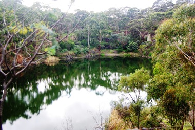
Photograph - Digital image, Marilyn Smith, Blue Lake 1, 19/06/2015
Blue Lake is in Yellow Gum Park in the Plenty Gorge, north of Greensborough.Digital copy of colour photographsyellow gum park, blue lake, plenty gorge park -
 Greensborough Historical Society
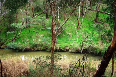
Photograph - Digital image, Marilyn Smith, Blue Lake 2, 19/06/2015
Blue Lake is in Yellow Gum Park in the Plenty Gorge, north of Greensborough.Digital copy of colour photographsyellow gum park, blue lake, plenty gorge park -
 Greensborough Historical Society
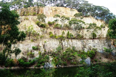
Photograph - Digital image, Marilyn Smith, Blue Lake: the escarpment, 19/06/2015
Blue Lake is in Yellow Gum Park in the Plenty Gorge, north of Greensborough.Digital copy of colour photographsyellow gum park, blue lake, plenty gorge park -
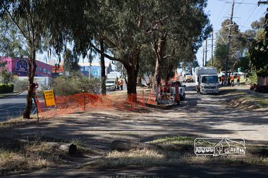 Eltham District Historical Society Inc
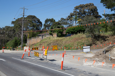
Photograph, Peter Pidgeon, Bolton Street upgrade, Eltham, 13 November, 2017, 13/11/2017
North bound lane closure, near Bridge Street, McDonalds on left. Born Digitalbolton street, bolton street upgrade, eltham, streets, mcdonalds restaurant -
 Eltham District Historical Society Inc
Photograph, Peter Pidgeon, Bolton Street upgrade, Eltham, 13 November, 2017, 13/11/2017
North bound lane closure, near Bridge Street, McDonalds on left. Born Digitalbolton street, bolton street upgrade, eltham, streets, mcdonalds restaurant -
 Eltham District Historical Society Inc
Photograph, Peter Pidgeon, Bolton Street upgrade, Eltham, 13 November, 2017, 13/11/2017
North bound lane closure, near Bridge Street, McDonalds on left. Born Digitalbolton street, bolton street upgrade, eltham, streets, middy's -
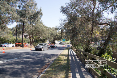
 Eltham District Historical Society Inc
Photograph, Peter Pidgeon, Intersection with Grand Boulevard, Bolton Street upgrade, Eltham, 13 November, 2017, 13/11/2017
North bound lane closure, near Bridge Street, McDonalds on left. Born Digitalbolton street, bolton street upgrade, eltham, streets, grand boulevard -
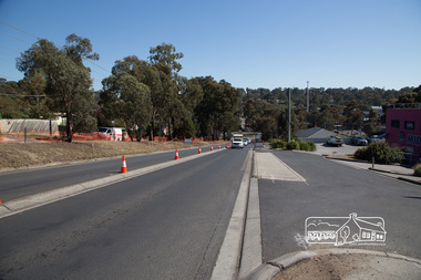
 Eltham District Historical Society Inc
Photograph, Peter Pidgeon, Bolton Street upgrade, Eltham, 13 November, 2017, 13/11/2017
North bound lane closure, near Bridge Street, McDonalds on left. Born Digitalbolton street, bolton street upgrade, eltham, streets, eltham ridge, shops -
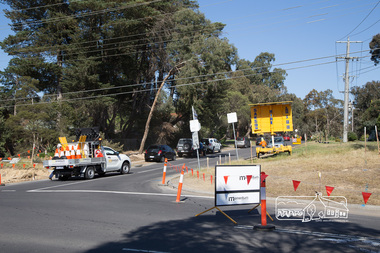
 Eltham District Historical Society Inc
Photograph, Peter Pidgeon, Intersection with Pedersen Way, Bolton Street upgrade, Eltham, 13 November, 2017, 13/11/2017
North bound lane closure, near Bridge Street, McDonalds on left. Born Digitalbolton street, bolton street upgrade, eltham, streets, pedersen way -
 Eltham District Historical Society Inc
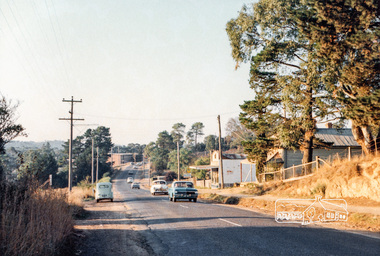
Photograph, Michael Aitken, Main Road, Eltham, c.1967, 1967c
Looking north from near Bridge Street. York Street on right.Digital file only Photo scanned from the collection of Michael Aitken on loan to EDHS, 13 Feb 2018michael aitken collection, postcards, eltham, main road, shillinglaw cottage, shillinglaw trees, york street, bakery -
 Tatura Irrigation & Wartime Camps Museum
Book, African Trilogy
Contains well known stories of the North African campaign of 1939- 1943Yellow soft cover book with photo of tanks on the front and back coversafrican trilogy, moorehead a, tatura, ww2, camp 13, boosk, history, local -
 Lake Bolac & District Historical Society
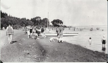
Black and white photograph, Swimming at Lake Bolac, 1946
Lake Bolac. Swimming at the 1st beach on the north side of the lake in 1946.lake bolac, swimming, 1946 -
Tatura Irrigation & Wartime Camps Museum
Photograph, Former Bank of New South Wales
Former Bank of New South Wales, Hogan Street, north side. -
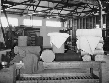 Stawell Historical Society Inc
Photograph, orth Western Woollen Mills -- Finishing Dept Raising Gig
North Western Woollen Mills -Framed - Finishing Dept. Raising Gigstawell industry -
Clunes Museum
Pamphlet
MR.JOHN LEWIS WAS MANAGER OF NEW NORTH CLUNES MINE CIRCA 1876.PHOTOCOPY LEAFLET McLEAN, BROS & RIGG IMPORTERS, WHOLESALE & RETAIL FURNISHING AND GENERAL IRONMONGERS.72 3829 ME. LEWIS 77 HUNTER ST. CASTLEMAINElocal history, document, pamphlet, mining -
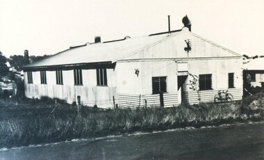 City of Ballarat Libraries
Photograph - Card Box Photographs, Original site of Amcast, Ballarat circa 1954
The original site for Amcast was in Lydiard Street North but is now in Elsworth Street.amcast, lydiard street north, building, manufacturing -
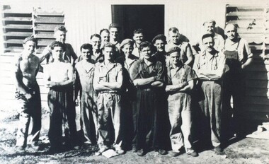 City of Ballarat Libraries
Photograph - Card Box Photographs, Original staff of Amcast, Ballarat circa 1954
The original staff of Amcast stand outside the site on Lydiard Street North.amcast, lydiard street north, manufacturing, people -
 City of Ballarat Libraries
Photograph - Card Box Photographs, St Paul's Catholic Technical School, Ballarat circa 1960. From Bartrop's Consultants File
The school was located on Lydiard Street North. Now known as 'Ludbrook House'st paul's technical school, education, building, public, lydiard street north, ludbrook house, ballarat -
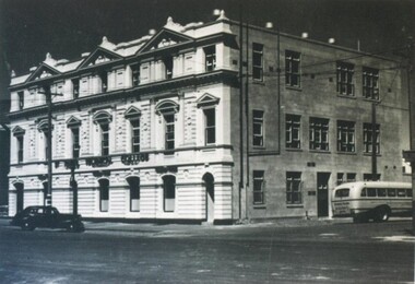
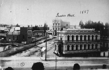 City of Ballarat Libraries
Photograph - Card Box Photographs, State Savings Bank, Trades Hall & Police Station, Ballarat 1887
Shows the view north along Camp Street from Sturt Street.ballarat trades hall, state savings bank, police station, public, buildings, commerical