Showing 1425 items matching " allotments"
-
 Ringwood and District Historical Society
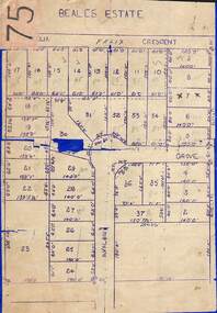
Map, Subdivision Plan of 37 residential allotments on Panorama Avenue, Felix Crescent, Evelyn Road and Avalon Grove, Ringwood, Victoria - (Undated - circa 1960)
... Subdivision Plan of 37 residential allotments on Panorama ...Stencilled copy of map on blue cardboard backingBeales Estate -
 Ringwood and District Historical Society
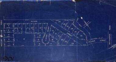
Map, Subdivision Plan of residential allotments in Mullum Mullum Road, Oliver Street and Lister Court, Ringwood, Victoria - (Undated)
... Subdivision Plan of residential allotments in Mullum Mullum ...Blueprint copy on cardboard backingNorth directional indicator includes name of Surveyor and Town Planner, Saxil Tuxen. -
 Ringwood and District Historical Society
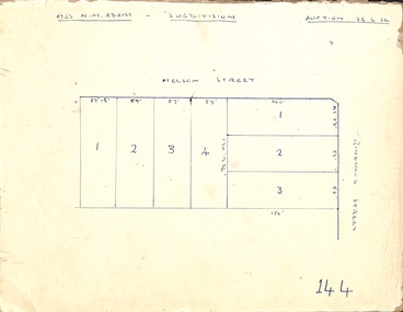
Map, Hand-drawn outline of residential allotments in Nelson Street and Ringwood Street, Ringwood, Vic., headed Mrs N.M. Adam - Subdivision - Auction 26.6.54
... Hand-drawn outline of residential allotments in Nelson ...Pen drawing on cardboard backing. -
 Ringwood and District Historical Society
Document - Subdivision Map, Layout of 72 residential allotments off Oban Road, Ringwood, Victoria - (Undated, circa 1960s)
... Layout of 72 residential allotments off Oban Road, Ringwood ...Foolscap size page Subdivision includes Oban Road, Frederic Drive, Baron Court, Towerhill Drive, Tyson Court, Adele Court, Marilyn Street and Abbey Court, Ringwood. Notations include LP89649. -
 Ringwood and District Historical Society
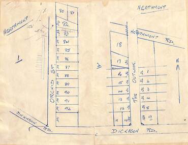
Map - Subdivision Plans, Residential allotments in Orchid Street and The Outlook, between Heathmont Road and Dickason Road, Heathmont, Victoria - (Undated - circa 1940)
... Residential allotments in Orchid Street and The Outlook ...Two adjoing hand-drawn maps on light cardboard backing. -
 Bendigo Historical Society Inc.
Map - KAMAROOKA ALLOTMENTS, 7/06/1894
... allotments ...Map: Parish of Kamarooka Allotments, County of Bendigo. Parish plan (number 288 in map cupboard 1)map, bendigo, allotments, kamarooka, allotments -
 Bendigo Historical Society Inc.
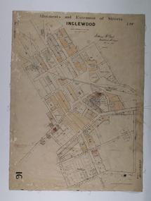
Map - Map of Inglewood, July 23rd 1857
... Allotments ...Map of Allotments and Extension of Streets INGLEWOOD, light cream coloured background black ink, some allotments are highlighted with darker cream infills. On paper with cloth backing.map, township, allotments, inglewood -
 Ringwood and District Historical Society
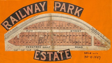
Flyer, Subdivision sale poster - Railway Park Estate, Ringwood, Victoria - 1887
Collage of clipped lettering and map pasted to orange coloured card depicting Railway Park Estate subdivision sale. Handwritten names associated with allotments and notation of sale date - 30 November, 1887. Subdivision plan with pink shading highlighting 73 allotments in Ferntree Gully Road (later Bedford Road) and Pitt Street, Ringwood. Handwritten names associated with allotments include Arthur Wiseman, T. Grant, J.J. Miller, M. Dickson, G.G. Miller, J. Frost, J.K. Turnbul, J.W. Davis, William Aldridge. Additional hand-drawn map on cardboard backing labeled Allotments for Sale at Ringwood - Part of Crown Allotment 17. -
Bendigo Historical Society Inc.
Map - HUNTLY ALLOTMENTS, No date visible
... allotments ...Map; Huntly Allotments, County of Bendigo. Parish plan (number 289 in map cupboard 1)map, bendigo, allotments, huntly allotments -
 Mt Dandenong & District Historical Society Inc.
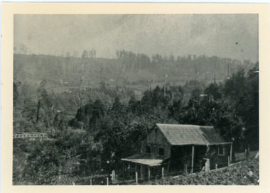
Photograph, Harry Child's Hut, early 1900s
Home of Harry Child in foreground built on the southern boundary of his father's (Francis Matthew Child) allotment. Black and white photograph showing the home of Harry Child. This photograph has a detailed inscription on the back handwritten by John Lundy-Clarke.The eastern face of Mt Dandenong from F.M. Childs selection Cnr allotment D.francis matthew child, mt dandenong, harry child -
Bendigo Historical Society Inc.
Map - PARISH OF MARONG ALLOTMENTS, No date Visible
... allotments ...Map: Parish of Marong Allotments, County of Bendigo. Parish plan Blueprint (number 286 in map cupboard 1)map, bendigo, allotments, marong allotments -
Whitehorse Historical Society Inc.
Map, Parishes of Bulleen, Boroondara, Prahran and Nunawading, 1850
Photocopy of map and tables of corners of allotments.Photocopy of map and tables of corners of allotments. Note on verso: Nunawading, Boroondara, Prahran. Allotments in the Parish surveyed by Lindsay Clarke 1850 (note by Robert Hoddle, surveys by Unwin, Elgar and Dendy indicated)Photocopy of map and tables of corners of allotments. maps, parish of bulleen, parish of boroondara, parish of prahran, parish of nunawading, clarke, lindsay, hoddle, robert -
Whitehorse Historical Society Inc.
Map, Boroondara, Nunawading, 1853
Map of section of Parishes of Boroondara and NunawadingMap of section of Parishes of Boroondara and Nunawading with allotments numbered and named. Note on verso: Boroondara and Nunawading c1853.Map of section of Parishes of Boroondara and Nunawading maps, parish of nunawading, parish of boroondara -
 Bendigo Historical Society Inc.
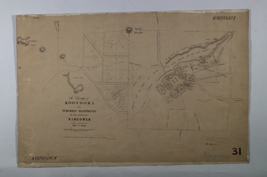
Map - KOOYOORA, July 23rd 1857
... Allotments ...Map: The Township of Kooyoora and suburban allotments in the Parish of Kingower. This plan has been applied to a newer backingmap, township, kooyoora, allotments, parish of kingower -
Whitehorse Historical Society Inc.
Document, Heatherdale Estate, Mitcham, n.d
Private sale brochure for the Heatherdale Estate, Mitcham.Private sale brochure for the Heatherdale Estate, Mitcham, comprising 195 allotments. Sale agent Drake & Co., Mitcham.Private sale brochure for the Heatherdale Estate, Mitcham. heatherdale estate, mitcham, kulnine avenue, mitcham, purches street, mitcham, culwel avenue, mitcham, walwa street, mitcham, blossom street, mitcham, nymph street, mitcham, heatherdale road, mitcham, drake co. -
Bendigo Historical Society Inc.
Map - CRAVEN'S ALLOTMENTS , NEW CHUM, No date visible
... allotments ...Map: Craven's Allotments, New Chum. Hand Draughted plan showng the corner of McKenzie and Rose streets Bendigo.map, bendigo, allotments, cravens allotments, new chum -
 Kiewa Valley Historical Society
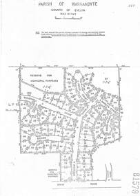
Parish Maps - Kiewa Valley
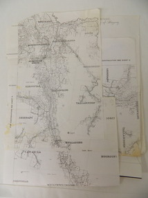
The Parish Maps show how the Counties were divided into allotments for buyers. On one the original owners are named and the sizes of their properties given. The reference numbers enable individuals research the history of the property. The other is on a smaller scale giving only the allotment numbers. The map with the names gives information on the early settlers of the Kiewa Valley. They show how the Kiewa Valley was divided up into allotments for town dwellers and farmers and enables further research.Two copies of Parish Maps of the towns in the Kiewa Valley. One gives the original owners and the other the reference numbers of the allotments.kiewa valley. parish maps. land owners -
Linton and District Historical Society Inc
Purchase Document, Grant By Purchase, Special Land Sale,1861: Sale of land to Henry Franks
The Allotment was purchased as part of a sale of Special Lands at Linton on the 9th of April 1861 The amount paid was £16 15s.Photocopy of a document which records the purchase by H. Franks of Allotment 15, Section 1, Township of Linton. henry franks, allotment 15 section 1 township of linton, special land sale 1861, documents and records -
Whitehorse Historical Society Inc.
Document, The Savage Estate, n.d
Private sale leaflet of The Savage Estate Springfield Road, Nunawading.Private sale leaflet of The Savage Estate Springfield Road, Nunawading, comprising 46 allotments. Agents Drake & Co and Armstrong & Hoath.Private sale leaflet of The Savage Estate Springfield Road, Nunawading. savage estate, nunawading, springfield road, nunawading, drake co, armstrong hoath estate agents -
Whitehorse Historical Society Inc.
Map, Plan of the Parish of Nunawading, 1853
Photocopy of map showing names of selectors, also list of references to the corners of allotments.Photocopy of map showing names of selectors, also list of references to the corners of allotments. Note on verso:'Gardiners Creek, Ballyshanassey township surveyed by H. Parmein, Surveyor General's Office Nov 30, 1853 also Reference to the Corners of allotments' (Plan 428)Photocopy of map showing names of selectors, also list of references to the corners of allotments. land subdivision, gardiners creek, ballyshanassy, parmein, h, burwood east, maps -
Linton and District Historical Society Inc
Documents - purchase of land, Purchase of land by David McFadzean, 1872 - Allotment A1A, Township of Linton, Parish of Argyle
The land was purchased by David McFadzean under the 42nd section of the Amending Land Act, 1865. This allowed long-term tenants ("licensees") of government-held land to purchase ("alienate") the land. The allotment is in present-day Jackson Street, Linton.Twelve A4-size photocopies of documents relating to the purchase of an allotment of land - Allotment A1A, measuring 5 acres, 3 roods and 37 perches - within the boundaries of the Township of Linton. First page is headed "SECTION 31, "LAND ACT 1869". Documents include David McFadzean's application to purchase, notes made about the land and the application by officers of the Board of Land and Works, a plan of the allotment, and information about purchase price and fees.allotment a1a township of linton, david mcfadzean, victoria. amending land act 1865, conveyance, land sales, land purchases, documents and records, james beament -
Bendigo Historical Society Inc.
Map - CAMPBELL COLLECTION: BENDIGO AND DISTRICT MAPS
... allotments ...Map. Whirrakee, Parish of Whirrakee. Total area of map 4419 acres. Scale 20 chains to 1 inch. 23 allotments are sold, Eucalypt oil distillery on lower portion of map. Prepared in W.P.B. from Assessor's plan and Parish Plan. (number 350 in map cupboard 1)map, bendigo, allotments -
 Ringwood and District Historical Society
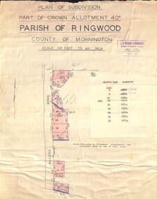
Map - Plan of Subdivision, Part of Crown Allotment 40C, Parish of Ringwood, County of Mornington - (Undated, circa 1940s)
Copy of land title map in manilla folder showing layout and size of residential allotments in Allens Road Heathmont, Victoria.J.S. Watson & Associates, Surveyors & Chartered Engineers, 7 Main Street Mornington, (Tel) Mornington 86. Typewritten sales notations attached for some allotments with rubber stamp impression - H.G. McLean, Builder, 5 Whitehorse Road, Ringwood. -
Bendigo Historical Society Inc.
Map - AVAILABLE ALLOTMENTS, 10/08/1908
... allotments ...map: Available Allotments, Parishes of Whirrakee, Bagshot and Egerton, County of Bendigo. Parish plan (coloured) (number 330 in map cupboard 1)map, bendigo, allotments, available allotments, whirrakee, bagshot, egerton -
 Ringwood and District Historical Society
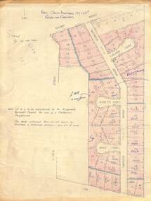
Map - Plan of Subdivision, Part of Crown Allotment 27 & 27B, Parish of Ringwood - (Undated, circa late 1950s)
Copy of land title map in manilla folder showing layout and size of 60 allotments in Railway Avenue, Victoria Street, Smithdene Avenue, Richard Court, Jeanette Court, Bruce Court and Loma Street, Ringwood East, Victoria.Note: Lot 15 is to be transferred to the Ringwood Borough Council for use as a children's playground. Map includes handwritten sales notations for several allotments, e.g. Sold. -
 Bacchus Marsh & District Historical Society
Map, Plan of the second portion of the property of Messers Atkins and Clarke situate at Bacchus Marsh 1856
This plan of land allotments for sale indicates part of the property once owned by the Bacchus family in and around the township area of Bacchus Marsh. The Bacchus family sold their property in Bacchus Marsh to John Aitkins and Robert Nalder Clarke in March 1851. Aitkins and Clarke kept the property for a number of years until April 1856 when these allotments were put up for sale.This is a very early land sales plan for agricultural land close to the township of Bacchus Marsh. It therefore provides some clues as to how the early urban development of the township and agricultural development of the nearby area took place. Upon seeing the map in 1911 Bacchus Marsh Express newspaper editor Christopher Crisp wrote "The sale appears to have created the present township, which had a nucleus in earlier times further east", Express, 30 September, 1911, page 3.A single page paper plan showing allotments of land for sale. The subdivided land shown was owned by John Aitkins and Robert Nalder Clarke, but previously owned by the Bacchus Family and was in and around their Manor House (Mansion) property in Bacchus Marsh. This plan shows allotments in the second portion of land to be sold which was located east of the Manor House on the eastern side of the Lerderderg River. The land for sale was made up of 15 allotments. The plan is pasted into a bound volume containing 76 maps or plans in total. BMDHS Loc: AR/B12/S4 Bacchus Marsh Township and Nearby Districts Maps Volume In-house Digital copies: BMDHS, Computer Network: Maps\Bacchus Marsh Township and Nearby Districts Maps Volumebacchus marsh victoria maps, bacchus family, land sales, manor house bacchus marsh -
 Bacchus Marsh & District Historical Society
Map, Plan of Survey of Part of Crown Allotment 9, Parish of Korkuperrimul, 1890
This map documents a transfer of an allotment of land in Clarke Street Bacchus Marsh in 1890. Clarke Street is located on the eastern side of Bacchus Marsh not far from Main Street and Crook Street. It is now known as Candeloro Street. The map indicates J. Booth as the owner of the land and H. Simpson as the occupier. Next to this allotment is a an allotment of land owned by J. Elmore,Single page map showing Crown allotment 9, Parish of Korkuperrimul, County of Bourke. Scale 100 feet to inch. Part of a set of maps which are pasted into a bound volume containing 76 maps or plans in total. High resolution digital image stored on BMDHS computer network. At bottom of map: I hereby certify that I have made this survey expressly for the purpose of an application under the Transfer of Land Statute that this plan is correct. Barry B???, Lic. Surveyor, 16.10.90bacchus marsh victoria maps, clarke street bacchus marsh maps -
Whitehorse Historical Society Inc.
Document, McGlone's Estate Mitcham, 1/04/1921 12:00:00 AM
Copy of pamphlet of McGlone's Estate, Mitcham auctioned April 1921.Copy of pamphlet of McGlone's Estate, Mitcham auctioned April 1921. 24 allotments. Bordered by Whitehorse Road, McGlone Street, Station Street and Mitcham railway line and station. Original in Haughton maps, LaTrobe Library.Copy of pamphlet of McGlone's Estate, Mitcham auctioned April 1921. land sales, auctions, mcglone, john, mcglone, elizabeth, whitehorse road, mitcham, mcglone street, mitcham, station street, mitcham, mitcham railway station, haughton map collection, state library of victoria. latrobe library -
University of Melbourne, Burnley Campus Archives
Book, Royal Horticultural Society, The Vegetable Garden Displayed, 1959
... allotments ...Book with light cardboard cover. Produced by the Royal Horticultural Society, London. Eleventh Impression 365th thousand, 1949. Very detailed descriptions of how to plant out gardens or allotments. Individual vegetables described. Photographs from Wisley, Surrey.vegetables, vegetable growing, home gardening, royal horticultural society, allotments, wisley -
Whitehorse Historical Society Inc.
Map, Site for Wesleyan Church, Nunawading, 1855
Photocopy of manuscript map showing names of landholders.Photocopy of manuscript map showing names of landholders. Note on verso: Plan of allotments in the City of Melbourne appropriated to the Wesleyans. Site for Wesleyan Church, Nunawading 1848 (Corner of Burwood and Elgar Roads - S of Burwood, W of Elgar)Photocopy of manuscript map showing names of landholders. churches, wesleyan church, burwood, burwood road, burwood, elgar road, burwood, maps