Showing 3431 items
matching distances
-
 Stawell Historical Society Inc
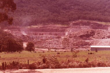
Slide, Ian McCann, Belfield dam from a distance, 1965
Colour Slide: Lake Bellfield from a Distancelake bellfield -
 Ringwood and District Historical Society
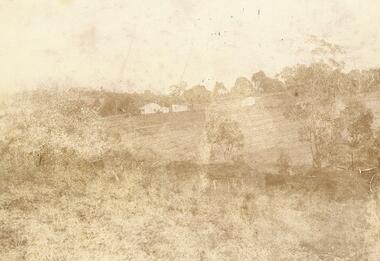
Photograph, "Quambee", North Ringwood, 1912 - viewed from Coombes' property
Sepia photograph showing the house and buildings in the distance.Written on rear of photograph: "Quambee, North Ringwood, 1912 - from Coombes' property." Quambee was owned by Augustus Temple Miles until 1916. -
 Ringwood and District Historical Society
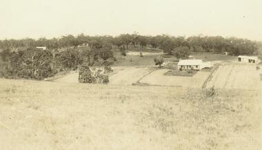
Photograph, "Quambee", North Ringwood - 1913
Sepia photograph showing house and outbuildings in the distance. -
 Phillip Island and District Historical Society Inc.
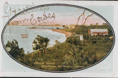
Photograph - Post Card, Early 1900's
One of 16 photographs and postcards donated by Mary KarneyColour postcard of Newhaven with pier and San Remo in the background."Greetings from Cowes" "Phillip Island Newhaven, San Remo in distance."newhaven jetty, newhaven beach, phillip island beaches, mary karney -
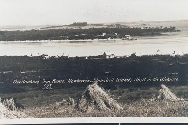 Phillip Island and District Historical Society Inc.
Photograph, Early 20th Century
One of 20 photographs/postcards donated by Mary KarneyBlack & White copy of postcard. View taken from San Remo overlooking township across the water to Newhaven, with Churchill Island and Rhyll in the background."Overlooking San Remo, Newhaven, Churchill Island; Rhyll in the distance. 285"san remo, newhaven phillip island, churchill island, rhyll phillip island, mary karney -
 Orbost & District Historical Society
black and white photograph, first half 20th century
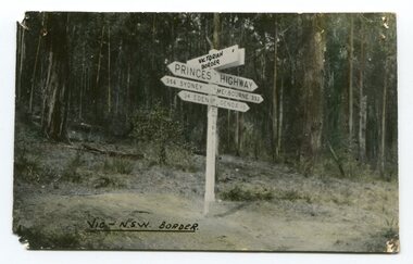
Prior to the sealing of the Princes Highway west of Orbost, the road surface was anything but good, even by C1917 when cars started to use the road. From Orbost the old road via Marlo to Sydenham was abandoned for the new location which traversed more rugged country via Cabbage Tree, Bell Bird and Club Terrace to Cann River, and the reason for this diversion was on account of settlements being established at Murrungowar and Club Terrace, at which latter place there was a temporary rush to obtain gold. This road was constructed by the Public Works department and a maximum grade of 1 in 19 was adopted, and as speed was not to be catered for the grade followed in and out round the spurs and gullies, resulting in a maze of turns and twists which required a good deal of skill on the part of the horse driver to negotiate." - Bairnsdale Advertiser, Friday, May 2, 1947. (More information from Newsletter February 2010)This is a pictorial record of an early road distance sign on a major highway through East Gippsland. The distances are indicated in miles, a measurement standard no longer in use.A black / white photograph postcard of the signpost at the Victorian - New South Wales border. It shows distances to Sydney and Eden on one arrow and distances to Melbourne and Genoa on another. on front - Vic - NSW Borderprinces-highway-east-gippsland road-transport road-sign -
 Federation University Historical Collection
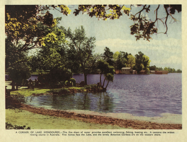
Photograph, A Corner of Lake Wendouree
A coloured image of Lake Wendouree with boat sheds in the distance.ballarat botanical gardens, lake wendouree, boats, boatshed, landscape, parks and gardens -
 Sunbury Family History and Heritage Society Inc.
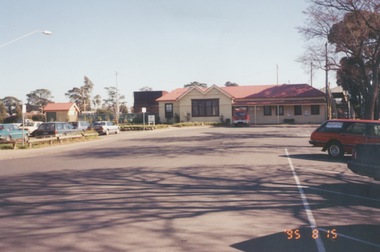
Photograph, 25th August 1995
This view of Sunbury Railway Station was taken from the corner of Brook and Evans Streets two years after the station underwent refurbishment and extensions and a carpark was constructed adjacent to the station. The Sunbury & District Heritage Association Inc. has a photograph P0663 of the station taken a century ago from the same place, when Sunbury was a small country town. The contrast between the two images is interesting. A coloured photograph of a streetscape with a weatherboard building in the middle distance,sunbury railway station, brook street -
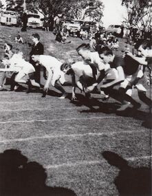 St Patrick's Old Collegians Association (SPOCA)
Photograph - Sports, Athletics
-
 Ringwood and District Historical Society
Photograph, Quambee, North Ringwood, from Coombes' property - 1912
Sepia photograph showing house and other buildings in the distance.Written on back of photograph, "Quambee - from Coombes, 1912." -
 Ringwood and District Historical Society
Photograph, Quambee, North Ringwood - 1912
Sepia photograph showing the house and other buildings in the distance.Written on rear of photograph: "Quambee 1912." -
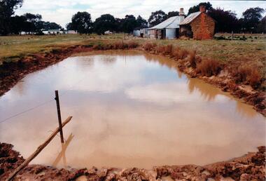 Hume City Civic Collection
Photograph, Early 1980's
The mud brick cottage and outbuilding was possibly built by James Waylett in the 1850's and it is only one of three remaining mud brick buildings in the Oaklands-Greenvale which were constructed in the late 19th Century.A coloured photograph of farm scene. A dam is in the foreground and the remains of a mud brick cottage and timber and corrugated building in the middle distance. Further farm buildings can be seen in the distance.mud brick buildings, waylett, james, farm buildings, sherwood, somerton road, oaklands hunt club, george evans collection -
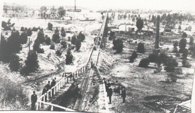 Bendigo Historical Society Inc.
Photograph - HARRY BIGGS COLLECTION: NEW MOON TRAMWAY, Circa 1900
Photograph of the New Moon battery Tramway, Eaglehawk. The tramway extends from the foreground into the far distance, the tramway is in a cutting in the foreground and on a trestle way in the distance. There is a group of men standing around a railing fence looking at the tramway. There is a large round brick chimney in the middle distance and another visible in the background.Robinsonplace, mining site, new moon, new moon, tramway, battery -
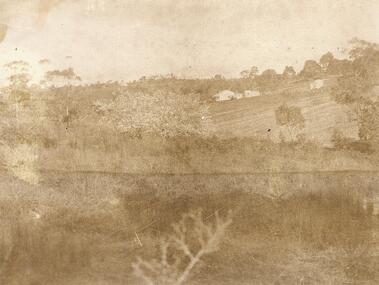
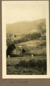 Mt Dandenong & District Historical Society Inc.
Photograph
The photograph is from the album of Ivy Child and shows a view across the Kalorama Valley sometime between 1927 and 1932. Ivy May Child (1910 – 1989) was the daughter of Arthur Edward (Ted) Child (1878 – 1964) and Ethel May Madden (1888 – 1970). Ted Child was the son of Matthew Francis Child (1839 – 1933) and Martha Jeeves (1857 – 1926). He was the grandson of one of the early pioneers Francis Child. Ivy grew up on the family property on Childs Road and took many photographs. Most of these are glued into her photo album. The album covered the years from c1927 – 1932. Ivy married Henry William Burgess (1906 – 1968) in 1944. The photographs remain in their original state in the album with individual copies made. Sepia coloured photograph with a wire and pole fence in the foreground of a sweeping view across a valley. Numerous roof tops are visible in the distance. The land has been cleared. Hills are in the distance.Written below the photograph in the album: The Valleykalorama valley, kalorama, ivy child -
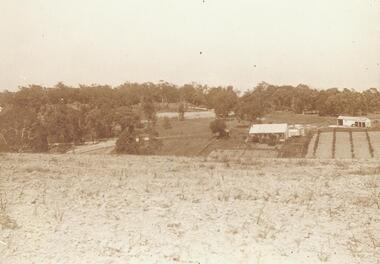
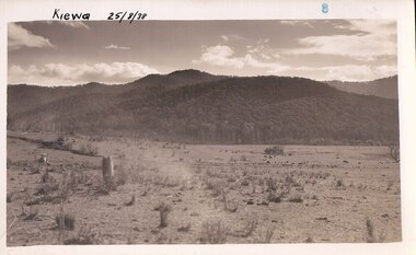 Kiewa Valley Historical Society
Photograph Farm Land, Kiewa, 25/8/38, circa 1938
This photograph was taken in august, 1938 some eight years prior to the establishment of Mt. Beauty as a township. The area was still being used for grazing cattle and the land was eventually acquired from the local land owners by the State Electricity Commission. The construction of the road, from Tawonga to the High Plains, was commenced in April of 1938. This allowed men and heavy equipment to be transported to the work sites for the construction of the Kiewa Hydro Electric Scheme. Prior to this access was by bridle trail, either on horse back or by foot. By 1946 housing construction had commenced for the new town of Mt. Beauty and by 1948 street construction in the southern part of the town was completed as far as Hill Street.This is an important photograph as it shows the upper Kiewa Valley and the site for Mt. Beauty as it was before the establishment of the town. The land has been cleared of natural vegetation and used for grazing cattle.Black and white photograph of farmland, cattle in the distance, hills in the backgroundHandwritten in the upper left hand corner, in black ink, 'Kiewa 25/8/38'. The number 8 has been stamped in the upper right hand side of the photograph. On the back have been stamped the words Velox, indicating the type of photographic paper.kiewa, mt. beauty, construction, grazing, secv -
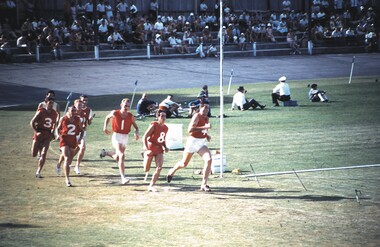 Bendigo Historical Society Inc.
Slide - VAL DENSWORTH COLLECTION: BENDIGO 2000, 1969
Slide. Bendigo 2000. Long distance runners around the track.slide, bendigo, bendigo 2000., bendigo 2000. -
 University of Melbourne, Burnley Campus Archives
Slide - Glass slide, 1891-1905
Post and rail fence, paddock and possibily Mount Buffalo in the distance.fence, paddock, farm work, mount buffalo -
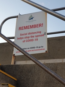 Ballarat Heritage Services
Photograph, Clare Gervasoni, Warrrnambool Covid19 signage, 2020, 29/06/2020
This photograph was when Regional Victoria was able to travel around the state, but Melbourne was still in Covid19 lockdown. Colour photograph of a Covid19 social distancing sign on the Warnambool breakwater.warrnambool, coast, breakwater, covid19, pandemic, social distancing -
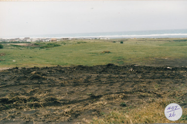 Port Fairy Historical Society Museum and Archives
Photograph
South Beach Development Coloured photograph of Earthworks on hill with south beach estate in distance407/26 (since removed 2021)south beach, development -
Stawell Historical Society Inc
Book, Wimmera Design & Print, Pomonal Bushfires
Following the Bushfires that burnt out 130,231 Hectares of the Grampians Region residents from Pomonal decided to write accounts of their own experiences during that fire. Card cover showing a Photo of a bush scene with a fire in the distancePomonal Bushfires Stories As Told By Those Who Were There January 22-27 2006mt luba bushfire, bushfire environment -
 University of Melbourne, Burnley Campus Archives
Photograph - Black and white print, A.W. Jessep, Plant Research Laboratory, 1941
Black and white photograph. Drive to Plant Research Laboratory in the distance.Handwritten on reverse, "Plant Research Laboratory. Oct. 1941 (South from Entrance) AWJ (A.W. Jessep) 10/9/42."plant research laboratory, a.w. jessep, plant research institute, entrance -
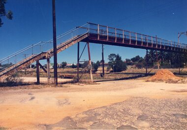 Stawell Historical Society Inc
Photograph, Railway Step Bridge Stawell
Railway Step Bridge StawellTwo (2) Colour Photgraphs of a Pedestrian Bridge across Railway Tracks. One showing the bridge in the mid distance, with a mound of soil in front. The Second looking across the bridge, with houses in the distancestawell, railway -
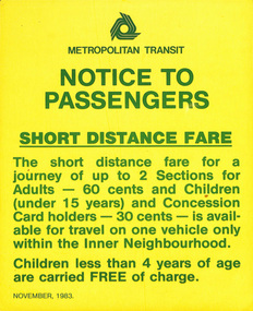 Melbourne Tram Museum
Poster, Metropolitan Transit Authority (MTA), "Notice to Passengers - Short Distance Fare", Nov. 1983
Poster - printed on paper, titled "Notice to Passengers - Short Distance Fare" about the availability of short distance fares - inner neighbourhood only. Issued by The Met or Metropolitan Transit Dated November 1983trams, tramways, tickets, travel cards, mmtb, short trip tickets, the met -
4th/19th Prince of Wales's Light Horse Regiment Unit History Room
Framed Picture, Victorian Cavalry 1890
Coloured picture of a standing Victorian Cavalry trooper. A mounted officer is in the distanceVictorian Cavalry 1890 Property of 4/19 PWLH Officers Mess FEB 96 -
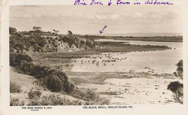 Phillip Island and District Historical Society Inc.
Photograph - Post Card, The Rose Stereographs, 1920's
Donated by S Serpell of Serpell & Reid families, SandringhamPostcard scene of the beach at Rhyll, Phillip Island with Cowes in the far distance.The Rose Series P. 3431. The Beach, Rhyll, Phillip island, Vic. On Back: New Year's Greeting written to Lena from Frank Kirkland - 30/12/1925. rhyll phillip sland, foreshore rhyll phillip island, s serpell -
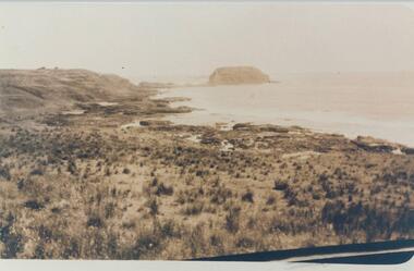 Phillip Island and District Historical Society Inc.
Photograph, Early 20th Century
One of a collection of photographs donated by Bruce Bennett.Coloured copy of a postcard showing The Nobbies in the distance across a coastal flatphillip island coastline, the nobbies phillip island, coastal scene phillip island, bruce bennett -
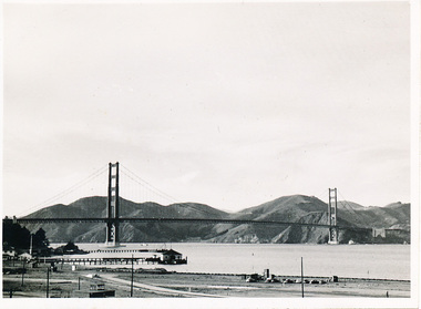 Mission to Seafarers Victoria
Photograph - Photograph, Black and white, Allan Charles Quinn, 9 November 1949
This photograph is part of series depicting Allan Quinn's travels through San Francisco in 1949. This photograph is a landscape shot of the Golden Gate Bridge.This is a photograph from the Allan Charles Quinn collection which is a collection of letters and photograph depicting aspects of life at sea for a young man in the era immediately following World War II.A black and white distance photograph of the Golden Gate Bridge, in San Francisco.Reverse: 9-11-49 handwritten in blue ink. K8 / B handwritten in pencil, upside.allan-quinn, photograph, san-francisco, golden-gate-bridge, 1949, merchant navy -
Glenelg Shire Council Cultural Collection
Negative - Negative - Glenelg River Nelson Bridge, Victoria, n.d
Transparency for black and white photo - Glenelg River with Nelson Bridge in the distance. -
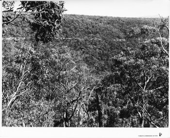 Halls Gap & Grampians Historical Society
Photograph - B/W, C 1960s (?)
The location in the photo is unknown.The photo shows a road, seen on a slope, in the distance, crossing through bushland'Forests Commission, Victoria' inscribed on bottom, right of border. 'Publicity & Public relations Branch, When reproducing please Acknowledge Forests Commission, Victoria, Negative No. 322-1' stamped on back.access routes, roads, scenery, grampians ranges -
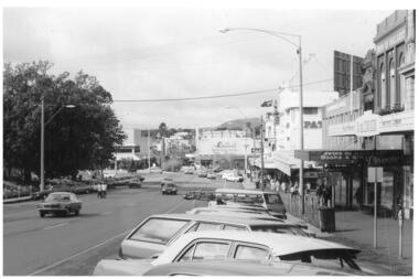 Federation University Historical Collection
Photograph - Black & White, Sturt Street Ballarat Looking Towards Bridge Mall, c1980, c1980
Photograph of Sturt Street Ballarat showing Ballarat and Bridge Mall in the distanceballarat, bridge mall, sturt street, cars