Showing 133 items
matching doncaster east
-
 Melbourne Tram Museum
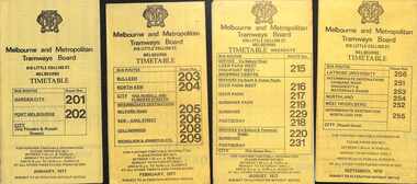
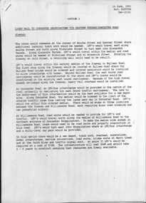
Ephemera - Timetables - MMTB Buses - set of 9, Melbourne & Metropolitan Tramways Board (MMTB), 1976 to 1978
... - Mitcham, East Doncaster, Ringwood - routes 287, 286, 288, 282, 283..., East Doncaster, Ringwood - routes 287, 286, 288, 282, 283, 272 ...Timetables - provide information on ticketing, fares, timing points, with a description of the route and a map. Not all services had been allocated a route number at the time. 1 - Garden City - Port Melbourne - City - routes 201 and 202 - Jan. 1977 2 - Bulleen - North Kew City - Routes 203, 204, 205, 206, 208 and 209 - Feb. 1977 3 - Deer Park West - Sunshine - Footscray - City - routes 215, 216, 217, 219. 218, 220, 231 with a Saturdays and Sundays timetable sheet printed on green paper - Aug. 1977 4 - La Trobe University - Northland - West Heidelberg - City - routes 256, 251, 253, 254, 252, 255 - Sept. 1978 5- Warrandyte - Park Orchards - Ringwood - routes 273, 274, 275 - June 1976 6 - Warrandyte - Donvale - Templestowe - Shoppingtown - City - routes 276, 277, 278, 294, 278, 280, 299, 268 - July 1976 7 - Box Hill - Mitcham, East Doncaster, Ringwood - routes 287, 286, 288, 282, 283, 272 - June 1976 8 - Box Hill - North Blackburn - route 290 - June 1976 9 - Box Hill - Heidelberg, East Doncaster, Shopping town - routes 291, 297, 296, 293, 271 and 269 - Sept. 1976Yields information about MMTB Bus services during the mid 1970s. Set of nine MMTB Bus timetables - multifolded printed on yellow paper, unless noted otherwise. timetable, mmtb, buses, port melbourne, garden city, deer park, fisherman's bend, west heidelberg, box hill, doncaster, shoppingtown, mitcham, ringwood, blackburn, templestowe, lower templestowe -
 Surrey Hills Historical Society Collection
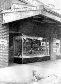
Photograph, Emma and William Atkinson's mixed business at 815 Whitehorse Road
... Emma was born in East Doncaster in 1903, the daughter... Road Canterbury melbourne Emma was born in East Doncaster ...Emma was born in East Doncaster in 1903, the daughter of Carl Heinrich Uebergang and Sarah Buck. Emma’s grandparents were pioneers in Doncaster from 1855 and her father had an orchard in Andersons Creek Road. Mr & Mrs Atkinson had a green-grocery business and general store at 815 Whitehorse Road, almost on the corner of Elgar Road from 1930 until about 1950 . Lloyd's butchers business was next door. In retirement the couple lived at 63 Zetland Road, Mont Albert and William continued to work as an orchard hand. Emma died in 2000 and is buried in Templestowe Cemetery. (See file for further details).A black and white photograph of a shop front. The verandah advertises "tobacco and cigarettes", "Minties", "Fruiterer". A small dog is standing on the pavement.lloyds butchers, elgar road, whitehorse road, box hill, animals, william james atkinson (mr), fruiterer and greengrocer, emma gerte uebergang (miss), emma gertrude uebergang (miss) -
 Surrey Hills Historical Society Collection
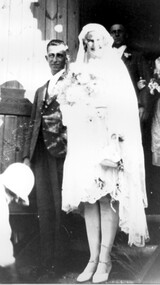
Photograph, Mr William and Mrs Emma Atkinson on their marriage in 1930
... Atkinson in 1930. Emma was born in East Doncaster in 1903... married William James Atkinson in 1930. Emma was born in East ...Emma Gerte (Gertrude) Uebergang married William James Atkinson in 1930. Emma was born in East Doncaster in 1903, the daughter of Carl Heinrich Uebergang and Sarah Buck. Emma’s grandparents were pioneers in Doncaster from 1855 and her father had an orchard in Andersons Creek Road. Mr & Mrs Atkinson had a greengrocery business and general store at 815 Whitehorse Road, almost on the corner of Elgar Road from 1930 until about 1950. (See file for further details). In retirement the couple lived at 63 Zetland Road, Mont Albert and William continued to work as an orchard hand. Emma died in 2000 and is buried in Templestowe Cemetery. A black and white photograph of a happy bridal couple. The lady is wearing a knee length dress and a calf length veil. The man is dressed in a suit. The bride is carrying some flowers.wedding dresses, clothing and dress, miss emma gerte uebergang, mr william james atkinson -
 Surrey Hills Historical Society Collection
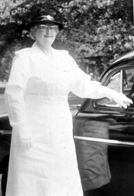
Photograph, Mrs Emma Atkinson
... Emma was born in East Doncaster in 1903, the daughter... Road Canterbury melbourne Emma was born in East Doncaster ...Emma was born in East Doncaster in 1903, the daughter of Carl Heinrich Uebergang and Sarah Buck. Emma’s grandparents were pioneers in Doncaster from 1855 and her father had an orchard in Andersons Creek Road, which was sold in 1961. Mr & Mrs Atkinson had a green-grocery business and general store at 815 Whitehorse Road, almost on the corner of Elgar Road from 1930 until about 1950. (See file for further details). In retirement the couple lived at 63 Zetland Road, Mont Albert and William continued to work as an orchard hand. Emma died in 2000 and is buried in Templestowe Cemetery. In this photo Mrs Atkinson is in the uniform of St. Johns Ambulance. In 1963 she was awarded a ‘Medal of Honour for Efficient Service’ by the Governor Sir Rowan Delacombe. (See file for further details) A black and white photograph of a lady dressed in a white uniform, complete with hat and gloves, standing beside a car.st. john ambulance, awards, miss emma gertrude uebergang, miss emma gerte uebergang, mrs william james atkinson, mrs emma atkinson -
 Melbourne Tram Museum
Ephemera - Timetable, Melbourne & Metropolitan Tramways Board (MMTB), Set of 14 MMTB Bus timetables, Jul. 1969
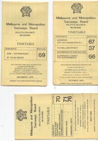
... - Heidelberg - Templestowe .2 - East Kew - Box Hill - Doncaster .3... - Templestowe .2 - East Kew - Box Hill - Doncaster .3 - Deer Park ...All July 1969 - no route numbers shown. .1 - Box Hill - Heidelberg - Templestowe .2 - East Kew - Box Hill - Doncaster .3 - Deer Park - Sunshine Park - Sunshine - Footscray - City .4 - Fishermen's Bend - City .5 - Williamstown Rd - Footscray Railway Stn - Ballarat Rd .6 - Garden City - City .7 - La Trobe University - Northland - West Heidelberg - City .8 - Box Hill - North Blackburn .9 - Bulleen - North Kew - City .10 - Clifton Hill - Elsternwick .11 - Box Hill - East Doncaster - Mitcham - Ringwood .12 - Deer Park - Sunshine Park - Sunshine - Footscray - City - Saturdays and Sundays - printed on pink paper. 13 - Warrandyte - Donvale Post Office - City 14 - Warrandyte - Park Orchards, Ringwood.Yields information about MMTB Bus services July 1969Set of 14 MMTB Bus timetables, folded sheets, providing timetables for specific routes, day of week giving information on tram times at specific time points, route map, sections and fares and organisation address - 616 Little Collins St. Melbourne.trams, tramways, timetables, tickets, bus services, fares, mmtb -
 Melbourne Tram Museum
Document - Report, Australian Electric Traction Association (AETA), Set of 6 options for Doncaster Light Rail Line, 1991
... East Doncaster 7 - Extension of the Camberwell Tram (72) along... East Doncaster 7 - Extension of the Camberwell Tram (72) along ...In 1991, the Australian Electric Traction Association (AETA) produced 7 different options to provide public transport to the Doncaster area. See reference for background to the proposals. Six of the seven options have been found and collected. Each option provides a summary, costing based in a scope of works. The Options were: 1 - Light Rail to Doncaster Shoppingtown via Eastern Freeway/Doncaster Road 2 - Light rail to Mitcham Road/Springvale Road 3 - High-performance train to Doncaster Shoppingtown via Victoria Park station Eastern Freeway/Doncaster Road 4 - Heavy rail to Doncaster Shoppingtown via Eastern Freeway to Bulleen Road and underground to Shoppingtown 5 - Heavy Rail to Blackburn Road/George St East Doncaster 7 - Extension of the Camberwell Tram (72) along Burke Road from Cotham Road to Doncaster Road. Out of all the studies, nothing happened.Yields information about the early 1990s proposal to provide public transport to the Doncaster area.Set of 6 reports or options printed on A4 paper, stapled in top left hand corner.tramcars, tramways, aeta, new tramways, doncaster, railways, light rail -
 Ballarat Tramway Museum
Ephemera - Timetable/s, Melbourne and Metropolitan Tramways Board (MMTB), Set of 14 MMTB Melbourne bus timetables, 1969
... .4 - Box Hill - East Doncaster via Blackburn, Mitcham via... - East Doncaster via Blackburn, Mitcham via Donvale PO ...Set of 14 MMTB timetables for various bus routes, dated July 1969. Generally includes Sat and Suns, Good Friday and Christmas day as well as weekdays, unless noted otherwise. Also includes a map of the route, detailed time points, sections, connecting services, fares, and organisation address - 616 Little Collins St. Melbourne. Have been folded into eight or ten portions. All on white paper unless noted otherwise. Items shown with an # - have a sticker modifying timetable information details on the front page. Items shown with a % are larger size sheets of paper, folded into 10. 1155.1 - Clifton Hill - Elsternwick # .2 - Garden City - City # .3 - Fishermen's Bend - City .4 - Box Hill - East Doncaster via Blackburn, Mitcham via Donvale PO and Mitcham - Ringwood via Eastland .5 - Warrandyte via Templestowe, via East Doncaster, Donvale PO - City % .6 - Warrandyte, Park Orchards Ringwood .7 - Williamstown Rd., Footscray Railway Station, Ballarat Rd # .8 - Latrobe University, Northland, West Heidelberg - City # % .9 - Deer Park, Sunshine Park, Sunshine, Footscray - City # .10 - as above, but for Saturdays and Sundays on pink paper # .11 - Box Hill, Heidelberg, Templestowe .12 - Box Hill, North Blackburn .13 - East Kew, Box Hill, Doncaster .14 - Bullen, North Kew - City # % Images of a sample of documents added 16-11-2013. mmtb, timetables, melbourne -
 Surrey Hills Historical Society Collection
Photograph, Albert Cunnington with horse and cart
... by Emma and William Atkinson. Emma was born in East Doncaster... in East Doncaster in 1903, the daughter of Carl Heinrich Uebergang ...The boy is Albert Cunnington who in about 1930 helped with deliveries for Atkinson's greengrocery business and general store located at 815 Whitehorse Road. The photo is taken in Whitehorse Road, near the corner of Elgar Road looking towards Zetland Road. No details are known about Albert. The business was owned by Emma and William Atkinson. Emma was born in East Doncaster in 1903, the daughter of Carl Heinrich Uebergang and Sarah Buck. Emma’s grandparents were pioneers in Doncaster from 1855 and her father had an orchard in Andersons Creek Road, which was sold in 1961. She married William James Atkinson in 1930 and the Atkinsons ran the store from c1930 to c1950. (See file for further details). In retirement the couple lived at 63 Zetland Road, Mont Albert and William continued to work as an orchard hand. Emma died in March 2000 and is buried in Templestowe Cemetery. (Chivers Lawn TE-CHI_L*H***28) along with her husband who died in 1977.A black and white photograph of a young boy holding a horse, who is attached to a cart.land transport, carts and wagons, horse drawn vehicles, fruiterer and greengrocer, mont albert, box hill, whitehorse road, elgar road, mr william james atkinson, miss emma gerte uebergang, mrs emma gertrude atkinson, mr albert cunnington -
 Melbourne Tram Museum
Map, Melbourne & Metropolitan Tramways Board (MMTB), MMTB Route Maps, 1979
... Doncaster & Warrandyte - R3/82 5 - City - Warrandyte & East... Doncaster & Warrandyte - R3/82 5 - City - Warrandyte & East ...Series of colour maps for various tram and bus routes, dated 1979. Also contained, not scanned are letters, reports, and specifications for printing these maps for use in shelters etc. Some have the Transport Information Centre telephone printed on them. Some are finished with a plastic laminate finish on either one or both sides. Show the major cross streets, parks, schools, other tram routes, major stop numbers, and railway lines. See also item 3909 for another example of these. Trams 1 - City route guide - R9/77 - showing all route numbers and destinations that passed through the CBD. 2 - Bourke St tram routes - R4/77 - East Brunswick Blyth St and East Preston Tyler St and intermediate routes, routes 95, 96, 97, 90, 89 and 88. 3 - Malvern, East Malvern, Carnegie, and East Brighton Tram Routes (from St Kilda Junction) - R1/79 - shows routes 5, 3, 67, 66, 61, 62, and 64. 4 - Elizabeth St tram routes - R12/77 - Essendon Airport, West Maribyrnong, North Coburg lines, routes 50, 58, 60, 54, 57, 52. 49, 59, 18, 20 and 19 5 - Flinders St tram routes - R5/78 - North Balwyn, East Burwood, routes 48, 40, 41, Hartwell, 28, 74 and 75 6 - Kew - St Kilda Beach - R1/79 - Route 69. 7 - Mont - Albert City - R11/77, shows routes 43. 47. 45. 44 8 - St Kilda Rd Tram Routes R12/77 - details South Melbourne Beach, route 1 and route 2 and St Kilda Beach routes 15, 16, and 55 otherwise shows where the various routes branch off St Kilda Road 9 - Batman Ave tram routes - R9/77 - Wattle Park, North Richmond and Prahran - routes 70, 71, 78 and 79. 10 - Footscray - Moonee Ponds - R3/81 - Route 82 11 - Swanston St tram guide - R1/79 - lists all routes and route numbers that branch or cross Swanston St between Grattan St and St Kilda Junction. 12 - Toorak Camberwell and Glen Iris tram route with Camberwell Junction and Malvern Town Hall, R1/79, routes 8, 7, 6, 72, and 73 shown. 13 - West Preston - Beach tram routes - R12/77 - routes 10, 11, 9 and 12, 14 - William St tram routes - R12/77 - Route 55, 56, and 63 - South Melbourne Depot and Domain. Buses 1 - Footscray, Sunshine, Deer Park, Nth Altona & Fishermans Bend - R2/79 2 - Box Hill bus routes to Templestowe, Heidelberg & East Kew - R6/78 - notes superseded by R3/82 3 - Plan of Russell St Melbourne bus departure bays. 4 - Box Hill, Mitcham & Ringwood bus routes to East Doncaster & Warrandyte - R3/82 5 - City - Warrandyte & East Doncaster bus routes - R3/82 & R6/78 6 - Bulleen - City - Port Melbourne - Garden City Bus route - R6/78 7 - North Altona - City bus route - 11/78 8 - Clifton Hill - Elsternwick - R2/79 9 - La Trobe - Northland - West Heidelberg - City Bus Service via East Freeway - 11/79 and R3/81 10 - Box Hill, Mitcham & Ringwood Bus Routes to East Doncaster & Warrandyte - R10/84 - with the Metropolitan Transit logo.Yields information about tram and bus routes in late 1970s early 1980s.Book - brown comb binding, card and clear plastic covers containing both bound and unbound maps and documents.K C Painter on front cover in ink.tramways, mmtb, tram routes, maps, bus routes, route numbers, routes, route guide -
 Melbourne Tram Museum
Ephemera - Timetables - MMTB Buses, Melbourne & Metropolitan Tramways Board (MMTB)
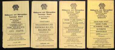
... 1974 10 - Box Hill - Mitcham, East Doncaster, Ringwood - routes..., 280, 299, 268 - April 1975 9 - East Kew, Box Hill Doncaster ...Timetables - provide information on ticketing, fares, timing points, with a description of the route and a map. Not all services had been allocated a route number at the time. 1 - Deer Park West - Sunshine - Footscray - City - Jan 1975, including a separate weekend timetable' 2 - Box Hill - Shoppingtown - Templestowe - May 1975 3 - Bulleen - North Kew City - Routes 203, 204, 205, 206, 208 and 209 - August 1972 4 - North Altona - City - route 232 - June 1979 5 - Clifton Hill - Elsternwick route - route 246, Point Ormond - route 247 and 248 - June 1974 6 - La Trobe University - Northland - West Heidelberg - City - routes 256, 251, 253, 254, 252, 255 - August 1974 7 - Warrandyte - Park Orchards - Ringwood - routes 273, 274, 275 - Feb. 1974 8 - Warrandyte - Donvale - Templestowe - Shoppingtown - City - routes 276, 277, 278, 294, 278, 280, 299, 268 - April 1975 9 - East Kew, Box Hill Doncaster, Shoppingtown - routes 284, 285, 270 - May 1974 10 - Box Hill - Mitcham, East Doncaster, Ringwood - routes 287, 286, 288, 282, 283, 272 - March 1974' 11 - Box Hill - North Blackburn - route 290 - March 1974 12 - Fishermans Bend - City - routes 233, 235, 237 - Feb 1979.Yields information about MMTB Bus services during the 1970s.Set of twelve MMTB Bus timetables - multifolded printed on yellow paper, except for Deer Park timetables for Saturdays and Sundays printed on green paper.timetable, the met, buses, box hill, doncaster, templestowe, warrandyte, elsternwick, fishermans bend, deer park, altona, sunshine, footscray, shoppingtown -
 Melbourne Tram Museum
Ephemera - Timetable/s, Melbourne & Metropolitan Tramways Board (MMTB), "MMTB Tram Timetables", 1977 to 1978
... (East Kew - Doncaster North) and 270 (East Kew - Shoppingtown... (East Kew - Doncaster North) and 270 (East Kew - Shoppingtown ...Set of 6 MMTB Tram timetables, folded sheets, 8 sections, providing timetables for specific routes, day of week giving information on tram times at specific time points, route map, sections and fares and organisation address - 616 Little Collins St. Melbourne. All printed on yellow paper. 1. - Route 67, 37 and 66 - Carnegie - City via Swanston St (67), via William St (37) and Glenhuntly Depot (66) - dated Oct. 1978. .2 - Route 69 - Kew Cotham Road - St Kilda Beach dated Dec. 1978 .3 - Route 70, 71 and 76 - Wattle Park - Batman Ave, Arraign Road (Route 71) and Camberwell Depot (Route 76), dated May 1978 .4 - Route 72, 32 and 73 - Camberwell City via Swanston St (72), via William St (32) and Camberwell Junction (73) dated Sept, 1978. .5 - Route 82 - Moonee Ponds - Footscray - Highpoint West - dated Sept. 1977 .6 - Route 88, 14, 89 and 90, 96, 95 and 97 - East Preston via Bourke St (88), via Latrobe St (14), East Preston Bell St (89) and Northcote Dundas St (90) to the city and East Brunswick (96), Exhibition (95) and North Fitzroy (Park St), dated May 1978. .7 - Routes 48, 24, 40, 41, 29, 74, 76. 28 - July 1978 .8 - ditto - Weekends, July 1978, printed on green paper. .9 - Bus routes 284 (East Kew - Doncaster North) and 270 (East Kew - Shoppingtown) - dated August 1978trams, tramways, mmtb, timetables, melbourne, fares, route 14, route 32, route 37, route 66, route 67, route 69, route 70, route 71, route 72, route 73, route 76, route 82, route 88, route 89, route 90, route 95, route 96, route 97, route 48, route 24, route 40, route 41, route 29, route 74, route 76, route 28, route 284, route 270 -
 Melbourne Tram Museum
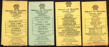
Ephemera - Timetable/s, Melbourne & Metropolitan Tramways Board (MMTB), "MMTB Bus Timetables", 1981 - 1984
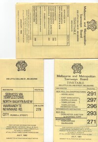
... East Doncaster, North Balwyn, Kew, Warrandyte, City... East Doncaster, North Balwyn, Kew, Warrandyte, City ...Timetables for specific routes, day of week giving information on tram times at specific time points, route map, sections and fares and organisation address - 616 Little Collins St. Melbourne. All printed on yellow paper. .1 - Timetable for Box Hill via Shoppingtown and Templestowe, Doncaster bus services, dated July 1981 - routes 291, 297, 296, 293 and 271. .2 - Services via Templestowe, North Balwyn and Kew, Warrandyte and Newmans Rd - routes 276, 278 and 279 - July 1982 .3 - Services via East Doncaster, North Balwyn, Kew, Warrandyte, City, Shoppingtown - routes 277, 280, 281 and 268 - dated Jan. 1983 .4 - ditto as above, including Park Orchards and Donvale - routes 265, 262, 261, 260, 266 and 264 - dated Feb. 1983 .5 - North Altona - City Route 232 - April 1984 - issued by Metropolitan Transit with their logo. 6 - Garden City, Port Melbourne - City - Sept 1982 - routes 201, 202 7 - Sunshine - Footscray - City - Routes 230 and 231 - Jan. 1982 8 - North Altona - City - MMTB logo, route 232 - Nov. 1982 9 - East Kew, Box Hill, Doncaster - Express bus - Box Hill to City - routes 284, 270, 300 - April 1982 10 - Ringwood - Warrandyte, Park Orchards, Mitcham - routes 313, 31, 315 and 316 - Jan. 1983Yields information about MMTB Bus services early 1980s and 1 The Met badged item.Set of 9 MMTB and 1 MTA Bus timetables, folded sheets, 8 sections.trams, tramways, mmtb, timetables, melbourne, fares, east kew, box hill, doncaster, north altona, route 232, route 201, route 202, route 220, route 231, route 284, route 270, route 300, route 313, route 314, route 315, route 316 -
 Melbourne Tram Museum
Ephemera - Timetable/s, Metropolitan Transit Authority (MTA), "MMTB Bus Timetables", 1984
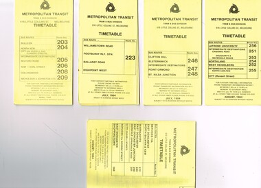
... , 299. 281 and 268 - services via East Doncaster, North Balwyn..., 299. 281 and 268 - services via East Doncaster, North Balwyn ...Set of 5 Metropolitan Transit Bus timetables, folded sheets, generally 8 or 10 sections, providing timetables for specific routes, day of week giving information on tram times at specific time points, route map, sections and fares and organisation address - 616 Little Collins St. Melbourne. All printed on yellow paper unless noted otherwise. .1 - Route 203, 204, 205, 206, 208. 209 - Bulleen, North Kew, Belford Road, Kew, Collingwood and Nicholson and Johnson St - City - April 1984 .2 - Route 223 - Williamstown Road, Footscray Railway Station, Ballarat Road and Highpoint West - July 1984 .3 - Route 246, 247, 248 - Clifton Hill, Elsternwick, Point Ormond and St Kilda Junction - July 1984 .4 - Route 256, 251, 253, 254, 252, 255 - Latrobe University, Northland, West Heidelberg - City - Aug./ 1984 .5 - Route 277, 280, 299. 281 and 268 - services via East Doncaster, North Balwyn and Kew - Warrandyte, Donvale, Shoppingtown - August 1984trams, tramways, metropolitan transit, timetables, melbourne, fares, buses, footscray, latrobe university, northland, heidelberg, warrandyte, doncaster, donvale, bulleen, north kew, williamstown rd, highpoint, clifton hill, elsternwick, point ormond, st kilda junction -
 Melbourne Tram Museum
Ephemera - Timetables - MMTB Buses - set of 13, Melbourne & Metropolitan Tramways Board (MMTB), 1971 to 1973
... - July 1972 9 - Box Hill, Mitcham, East Doncaster, Ringwood... - July 1972 9 - Box Hill, Mitcham, East Doncaster, Ringwood ...Timetables - provide information on ticketing, fares, timing points, with a description of the route and a map. Not all services had been allocated a route number at the time. 1 - Garden City - Port Melbourne - City - routes 201, 202 - August 1972 2 - Williamstown Road - Footscray - Ballarat Rd - Route 223, Feb. 1972 3 - Deer Park, Sunshine Park, Sunshine, Footscray - City - routes 217, 219, 220, 229, 231 and 218 - Feb. 1972 4 - Deer Park West, Sunshine Park, Sunshine, Footscray - City - July 1973 5 - Fishermen's Bend - City - routes 233, 235 and 237 - March 1972 6 - Clifton Hill - Esternwick - Point Ormond - routes 246, 247 and 248 - August 1972 7 - Latrobe Uni - Northland - West Heidelberg - City - routes 256, 251, 253, 254, 252 and 255 August 1972 8 - East Kew, Box Hill, Doncaster, Shoppingtown - routes 284, 285 and 270 - July 1972 9 - Box Hill, Mitcham, East Doncaster, Ringwood - routes 287, 286, 288, 282, 283, and 272 - July 1972 10 - Box Hill - North Blackburn, route 290, printed on white paper - Sep. 1971 11 - Box Hill - Doncaster, Shoppingtown, Heidelberg, Templestowe, Serpells Rd and Lower Templestowe - routes 293, 296, 297, 271 - July 1972 12 Deer Park, Sunshine Park, Sunshine, Footscray - City - routes 217, 219, 220, 229, 231 and 218 - Saturdays and Sundays, printed on green paper - Feb. 1972 13 - Fishermans Bend - City - routes 233, 235 and 237 - June 1973 Yields information about MMTB Bus services during the 1970s. Set of twelve MMTB Bus timetables - multifolded printed on yellow paper, unless noted otherwise. timetable, mmtb, buses, port melbourne, garden city, williamstown rd, footscray, ballarat rd, sunshine, deer park, fisherman's bend, clifton hill, esternwick, point ormond, la trobe university, northland, west heidelberg, east kew, box hill, doncaster, shoppingtown, mitcham, ringwood, blackburn, templestowe, lower templestowe, fishermans bend -
 Eltham District Historical Society Inc
Photograph, Looking north across the Fitzsimons Lane Bridge over Yarra River between Eltham and Templestowe, c.1985, 1985c
... of a friend in East Doncaster, but the return trip over the new bridge... of a friend in East Doncaster, but the return trip over the new bridge ...Turnoff to Candlebark Park on right. The bridge over the Yarra River was initially opened September 22nd, 1961. Newspaper reports at the time of opening stated it linked Bolton Street, Eltham, with Fitzsimons Lane, Templestowe. In 1955 the Country Roads Board (CRB) produced survey plans that showed proposed land acquisition for the future bridge and road approaches. The 1955 plan shows that it was proposed to connect Fitzsimons Lane with Bolton Street in Eltham by a diagonal road across the river. The road connection would then continue along Bolton Street to Main Road. Prior to construction of the bridge the CRB modified the proposal significantly so that there was a new road parallel with Bolton Street and then curving to join Main Road at what was then its intersection with Old Eltham Road. This involved significantly more land acquisition and altered the pattern of land subdivision through this corridor. Initially the new road was just a single two-way carriageway as it would have required a significant widening of the cutting on the Shire of Eltham side of the river. The road was officially un-named but was known locally as the Eltham-Templestowe Road. The 1966 Melway street directory and other 1960s editions also listed the road as the Eltham-Templestowe Road. In December 1970, Eltham Shire Council, in pursuance of the provisions of the Local Government Act, named it Templestowe Road. The road was renamed Fitzsimons Lane around 1984 in conformity with the section south of the river. In 1991 a new bridge was built to the west of the original bridge. Fitzsimons Lane was widened to four traffic lanes although on the Eltham side this was done within the limits of the existing cutting. NEW BRIDGE STARTS THEM EXPLORING Without any fanfares, Country Roads Board workmen on Friday afternoon put the finishing touches to the approaches, removed the barricades, and let the traffic roll over the new Yarra bridge linking Bolton Street, Eltham, with Fitzsimons Lane, Templestowe. Over the week-end many “bridge watchers” who were making one of their periodic inspections of the progress on the new bridge found to their surprise that they could drive over it, so that people who had gone for a run out to Eltham suddenly found themselves wandering through Templestowe and Doncaster. By Monday the word of the bridge’s opening had got around sufficiently for many regular travellers to the city from Eltham and beyond to vary the monotony by going to town via Templestowe and Kew instead of through Heidelberg. They were surprised at the distances – about 3 ½ miles from Eltham to Templestowe, 6 miles from Eltham Shire hall to the Lower Heidelberg Road-Banksia Street intersection. NEW NEIGHBOURS For people on both sides of the river, the new bridge has turned distant friends into near neighbours. A Greensborough man on Sunday took 35 minutes to reach the home of a friend in East Doncaster, but the return trip over the new bridge took only 17 minutes. It will be some time yet before most people work out the possibilities in shorter and quicker trips form the north-eastern areas to the eastern and south-eastern suburbs. The coming of the warmer months will soon teach many, though the short cuts to Peninsular beaches and eastern suburban drive-ins. And before very long it is likely there will be a Tramways bus running from Templestowe to Eltham station. NEW BRIDGE STARTS THEM EXPLORING (1961, September 27). The Diamond Valley News (News clipping held in SEA_74-1_047) The previously un-named road between Main Road and Yarra River, Eltham South, east of Bolton Street was named Templestowe Road, December 15, 1970 NAMING OF STREETS AND ROADS. (1970, December 15). The Diamond Valley News (News clipping held in SEA_74-2_022)Colour photographinfrastructure, shire of eltham infrastructure, bridge, fitzsimons lane bridge, yarra river, candlebark park, red nose day -
 Eltham District Historical Society Inc
Photograph, Fitzsimons Lane Bridge over Yarra River between Eltham and Templestowe
... of a friend in East Doncaster, but the return trip over the new bridge... of a friend in East Doncaster, but the return trip over the new bridge ...The bridge over the Yarra River was initially opened September 22nd, 1961. Newspaper reports at the time of opening stated it linked Bolton Street, Eltham, with Fitzsimons Lane, Templestowe. In 1955 the Country Roads Board (CRB) produced survey plans that showed proposed land acquisition for the future bridge and road approaches. The 1955 plan shows that it was proposed to connect Fitzsimons Lane with Bolton Street in Eltham by a diagonal road across the river. The road connection would then continue along Bolton Street to Main Road. Prior to construction of the bridge the CRB modified the proposal significantly so that there was a new road parallel with Bolton Street and then curving to join Main Road at what was then its intersection with Old Eltham Road. This involved significantly more land acquisition and altered the pattern of land subdivision through this corridor. Initially the new road was just a single two-way carriageway as it would have required a significant widening of the cutting on the Shire of Eltham side of the river. The road was officially un-named but was known locally as the Eltham-Templestowe Road. The 1966 Melway street directory and other 1960s editions also listed the road as the Eltham-Templestowe Road. In December 1970, Eltham Shire Council, in pursuance of the provisions of the Local Government Act, named it Templestowe Road. The road was renamed Fitzsimons Lane around 1984 in conformity with the section south of the river. In 1991 a new bridge was built to the west of the original bridge. Fitzsimons Lane was widened to four traffic lanes although on the Eltham side this was done within the limits of the existing cutting. NEW BRIDGE STARTS THEM EXPLORING Without any fanfares, Country Roads Board workmen on Friday afternoon put the finishing touches to the approaches, removed the barricades, and let the traffic roll over the new Yarra bridge linking Bolton Street, Eltham, with Fitzsimons Lane, Templestowe. Over the week-end many “bridge watchers” who were making one of their periodic inspections of the progress on the new bridge found to their surprise that they could drive over it, so that people who had gone for a run out to Eltham suddenly found themselves wandering through Templestowe and Doncaster. By Monday the word of the bridge’s opening had got around sufficiently for many regular travellers to the city from Eltham and beyond to vary the monotony by going to town via Templestowe and Kew instead of through Heidelberg. They were surprised at the distances – about 3 ½ miles from Eltham to Templestowe, 6 miles from Eltham Shire hall to the Lower Heidelberg Road-Banksia Street intersection. NEW NEIGHBOURS For people on both sides of the river, the new bridge has turned distant friends into near neighbours. A Greensborough man on Sunday took 35 minutes to reach the home of a friend in East Doncaster, but the return trip over the new bridge took only 17 minutes. It will be some time yet before most people work out the possibilities in shorter and quicker trips form the north-eastern areas to the eastern and south-eastern suburbs. The coming of the warmer months will soon teach many, though the short cuts to Peninsular beaches and eastern suburban drive-ins. And before very long it is likely there will be a Tramways bus running from Templestowe to Eltham station. NEW BRIDGE STARTS THEM EXPLORING (1961, September 27). The Diamond Valley News (News clipping held in SEA_74-1_047) The previously un-named road between Main Road and Yarra River, Eltham South, east of Bolton Street was named Templestowe Road, December 15, 1970 NAMING OF STREETS AND ROADS. (1970, December 15). The Diamond Valley News (News clipping held in SEA_74-2_022)Black and white photographinfrastructure, shire of eltham infrastructure, bridge, fitzsimons lane bridge, yarra river -
 Eltham District Historical Society Inc
Photograph, Looking south across the Fitzsimons Lane Bridge over Yarra River between Eltham and Templestowe
... of a friend in East Doncaster, but the return trip over the new bridge... of a friend in East Doncaster, but the return trip over the new bridge ...The bridge over the Yarra River was initially opened September 22nd, 1961. Newspaper reports at the time of opening stated it linked Bolton Street, Eltham, with Fitzsimons Lane, Templestowe. In 1955 the Country Roads Board (CRB) produced survey plans that showed proposed land acquisition for the future bridge and road approaches. The 1955 plan shows that it was proposed to connect Fitzsimons Lane with Bolton Street in Eltham by a diagonal road across the river. The road connection would then continue along Bolton Street to Main Road. Prior to construction of the bridge the CRB modified the proposal significantly so that there was a new road parallel with Bolton Street and then curving to join Main Road at what was then its intersection with Old Eltham Road. This involved significantly more land acquisition and altered the pattern of land subdivision through this corridor. Initially the new road was just a single two-way carriageway as it would have required a significant widening of the cutting on the Shire of Eltham side of the river. The road was officially un-named but was known locally as the Eltham-Templestowe Road. The 1966 Melway street directory and other 1960s editions also listed the road as the Eltham-Templestowe Road. In December 1970, Eltham Shire Council, in pursuance of the provisions of the Local Government Act, named it Templestowe Road. The road was renamed Fitzsimons Lane around 1984 in conformity with the section south of the river. In 1991 a new bridge was built to the west of the original bridge. Fitzsimons Lane was widened to four traffic lanes although on the Eltham side this was done within the limits of the existing cutting. NEW BRIDGE STARTS THEM EXPLORING Without any fanfares, Country Roads Board workmen on Friday afternoon put the finishing touches to the approaches, removed the barricades, and let the traffic roll over the new Yarra bridge linking Bolton Street, Eltham, with Fitzsimons Lane, Templestowe. Over the week-end many “bridge watchers” who were making one of their periodic inspections of the progress on the new bridge found to their surprise that they could drive over it, so that people who had gone for a run out to Eltham suddenly found themselves wandering through Templestowe and Doncaster. By Monday the word of the bridge’s opening had got around sufficiently for many regular travellers to the city from Eltham and beyond to vary the monotony by going to town via Templestowe and Kew instead of through Heidelberg. They were surprised at the distances – about 3 ½ miles from Eltham to Templestowe, 6 miles from Eltham Shire hall to the Lower Heidelberg Road-Banksia Street intersection. NEW NEIGHBOURS For people on both sides of the river, the new bridge has turned distant friends into near neighbours. A Greensborough man on Sunday took 35 minutes to reach the home of a friend in East Doncaster, but the return trip over the new bridge took only 17 minutes. It will be some time yet before most people work out the possibilities in shorter and quicker trips form the north-eastern areas to the eastern and south-eastern suburbs. The coming of the warmer months will soon teach many, though the short cuts to Peninsular beaches and eastern suburban drive-ins. And before very long it is likely there will be a Tramways bus running from Templestowe to Eltham station. NEW BRIDGE STARTS THEM EXPLORING (1961, September 27). The Diamond Valley News (News clipping held in SEA_74-1_047) The previously un-named road between Main Road and Yarra River, Eltham South, east of Bolton Street was named Templestowe Road, December 15, 1970 NAMING OF STREETS AND ROADS. (1970, December 15). The Diamond Valley News (News clipping held in SEA_74-2_022)Black and white photographinfrastructure, shire of eltham infrastructure, bridge, fitzsimons lane bridge, yarra river -
 Eltham District Historical Society Inc
Photograph, Fitzsimons Lane Bridge over Yarra River between Eltham and Templestowe
... of a friend in East Doncaster, but the return trip over the new bridge... of a friend in East Doncaster, but the return trip over the new bridge ...The bridge over the Yarra River was initially opened September 22nd, 1961. Newspaper reports at the time of opening stated it linked Bolton Street, Eltham, with Fitzsimons Lane, Templestowe. In 1955 the Country Roads Board (CRB) produced survey plans that showed proposed land acquisition for the future bridge and road approaches. The 1955 plan shows that it was proposed to connect Fitzsimons Lane with Bolton Street in Eltham by a diagonal road across the river. The road connection would then continue along Bolton Street to Main Road. Prior to construction of the bridge the CRB modified the proposal significantly so that there was a new road parallel with Bolton Street and then curving to join Main Road at what was then its intersection with Old Eltham Road. This involved significantly more land acquisition and altered the pattern of land subdivision through this corridor. Initially the new road was just a single two-way carriageway as it would have required a significant widening of the cutting on the Shire of Eltham side of the river. The road was officially un-named but was known locally as the Eltham-Templestowe Road. The 1966 Melway street directory and other 1960s editions also listed the road as the Eltham-Templestowe Road. In December 1970, Eltham Shire Council, in pursuance of the provisions of the Local Government Act, named it Templestowe Road. The road was renamed Fitzsimons Lane around 1984 in conformity with the section south of the river. In 1991 a new bridge was built to the west of the original bridge. Fitzsimons Lane was widened to four traffic lanes although on the Eltham side this was done within the limits of the existing cutting. NEW BRIDGE STARTS THEM EXPLORING Without any fanfares, Country Roads Board workmen on Friday afternoon put the finishing touches to the approaches, removed the barricades, and let the traffic roll over the new Yarra bridge linking Bolton Street, Eltham, with Fitzsimons Lane, Templestowe. Over the week-end many “bridge watchers” who were making one of their periodic inspections of the progress on the new bridge found to their surprise that they could drive over it, so that people who had gone for a run out to Eltham suddenly found themselves wandering through Templestowe and Doncaster. By Monday the word of the bridge’s opening had got around sufficiently for many regular travellers to the city from Eltham and beyond to vary the monotony by going to town via Templestowe and Kew instead of through Heidelberg. They were surprised at the distances – about 3 ½ miles from Eltham to Templestowe, 6 miles from Eltham Shire hall to the Lower Heidelberg Road-Banksia Street intersection. NEW NEIGHBOURS For people on both sides of the river, the new bridge has turned distant friends into near neighbours. A Greensborough man on Sunday took 35 minutes to reach the home of a friend in East Doncaster, but the return trip over the new bridge took only 17 minutes. It will be some time yet before most people work out the possibilities in shorter and quicker trips form the north-eastern areas to the eastern and south-eastern suburbs. The coming of the warmer months will soon teach many, though the short cuts to Peninsular beaches and eastern suburban drive-ins. And before very long it is likely there will be a Tramways bus running from Templestowe to Eltham station. NEW BRIDGE STARTS THEM EXPLORING (1961, September 27). The Diamond Valley News (News clipping held in SEA_74-1_047) The previously un-named road between Main Road and Yarra River, Eltham South, east of Bolton Street was named Templestowe Road, December 15, 1970 NAMING OF STREETS AND ROADS. (1970, December 15). The Diamond Valley News (News clipping held in SEA_74-2_022)Black and white photographinfrastructure, shire of eltham infrastructure, bridge, fitzsimons lane bridge, yarra river -
 Eltham District Historical Society Inc
Photograph, Russell Yeoman, Fitzsimons Lane Bridge over Yarra River between Eltham and Templestowe, c.1970, 1970c
... of a friend in East Doncaster, but the return trip over the new bridge... of a friend in East Doncaster, but the return trip over the new bridge ...The bridge over the Yarra River was initially opened September 22nd, 1961. Newspaper reports at the time of opening stated it linked Bolton Street, Eltham, with Fitzsimons Lane, Templestowe. In 1955 the Country Roads Board (CRB) produced survey plans that showed proposed land acquisition for the future bridge and road approaches. The 1955 plan shows that it was proposed to connect Fitzsimons Lane with Bolton Street in Eltham by a diagonal road across the river. The road connection would then continue along Bolton Street to Main Road. Prior to construction of the bridge the CRB modified the proposal significantly so that there was a new road parallel with Bolton Street and then curving to join Main Road at what was then its intersection with Old Eltham Road. This involved significantly more land acquisition and altered the pattern of land subdivision through this corridor. Initially the new road was just a single two-way carriageway as it would have required a significant widening of the cutting on the Shire of Eltham side of the river. The road was officially un-named but was known locally as the Eltham-Templestowe Road. The 1966 Melway street directory and other 1960s editions also listed the road as the Eltham-Templestowe Road. In December 1970, Eltham Shire Council, in pursuance of the provisions of the Local Government Act, named it Templestowe Road. The road was renamed Fitzsimons Lane around 1984 in conformity with the section south of the river. In 1991 a new bridge was built to the west of the original bridge. Fitzsimons Lane was widened to four traffic lanes although on the Eltham side this was done within the limits of the existing cutting. NEW BRIDGE STARTS THEM EXPLORING Without any fanfares, Country Roads Board workmen on Friday afternoon put the finishing touches to the approaches, removed the barricades, and let the traffic roll over the new Yarra bridge linking Bolton Street, Eltham, with Fitzsimons Lane, Templestowe. Over the week-end many “bridge watchers” who were making one of their periodic inspections of the progress on the new bridge found to their surprise that they could drive over it, so that people who had gone for a run out to Eltham suddenly found themselves wandering through Templestowe and Doncaster. By Monday the word of the bridge’s opening had got around sufficiently for many regular travellers to the city from Eltham and beyond to vary the monotony by going to town via Templestowe and Kew instead of through Heidelberg. They were surprised at the distances – about 3 ½ miles from Eltham to Templestowe, 6 miles from Eltham Shire hall to the Lower Heidelberg Road-Banksia Street intersection. NEW NEIGHBOURS For people on both sides of the river, the new bridge has turned distant friends into near neighbours. A Greensborough man on Sunday took 35 minutes to reach the home of a friend in East Doncaster, but the return trip over the new bridge took only 17 minutes. It will be some time yet before most people work out the possibilities in shorter and quicker trips form the north-eastern areas to the eastern and south-eastern suburbs. The coming of the warmer months will soon teach many, though the short cuts to Peninsular beaches and eastern suburban drive-ins. And before very long it is likely there will be a Tramways bus running from Templestowe to Eltham station. NEW BRIDGE STARTS THEM EXPLORING (1961, September 27). The Diamond Valley News (News clipping held in SEA_74-1_047) The previously un-named road between Main Road and Yarra River, Eltham South, east of Bolton Street was named Templestowe Road, December 15, 1970 NAMING OF STREETS AND ROADS. (1970, December 15). The Diamond Valley News (News clipping held in SEA_74-2_022)Roll of 35mm black and white negative film, 4 of 7 stripsIlford HP4bridge, bridges, fitzsimons lane bridge, infrastructure, shire of eltham infrastructure, yarra river -
 Eltham District Historical Society Inc
Photograph, Fitzsimons Lane Bridge over Yarra River between Eltham and Templestowe, c.1966, 1966c
... of a friend in East Doncaster, but the return trip over the new bridge... of a friend in East Doncaster, but the return trip over the new bridge ...The bridge over the Yarra River was initially opened September 22nd, 1961. Newspaper reports at the time of opening stated it linked Bolton Street, Eltham, with Fitzsimons Lane, Templestowe. In 1955 the Country Roads Board (CRB) produced survey plans that showed proposed land acquisition for the future bridge and road approaches. The 1955 plan shows that it was proposed to connect Fitzsimons Lane with Bolton Street in Eltham by a diagonal road across the river. The road connection would then continue along Bolton Street to Main Road. Prior to construction of the bridge the CRB modified the proposal significantly so that there was a new road parallel with Bolton Street and then curving to join Main Road at what was then its intersection with Old Eltham Road. This involved significantly more land acquisition and altered the pattern of land subdivision through this corridor. Initially the new road was just a single two-way carriageway as it would have required a significant widening of the cutting on the Shire of Eltham side of the river. The road was officially un-named but was known locally as the Eltham-Templestowe Road. The 1966 Melway street directory and other 1960s editions also listed the road as the Eltham-Templestowe Road. In December 1970, Eltham Shire Council, in pursuance of the provisions of the Local Government Act, named it Templestowe Road. The road was renamed Fitzsimons Lane around 1984 in conformity with the section south of the river. In 1991 a new bridge was built to the west of the original bridge. Fitzsimons Lane was widened to four traffic lanes although on the Eltham side this was done within the limits of the existing cutting. NEW BRIDGE STARTS THEM EXPLORING Without any fanfares, Country Roads Board workmen on Friday afternoon put the finishing touches to the approaches, removed the barricades, and let the traffic roll over the new Yarra bridge linking Bolton Street, Eltham, with Fitzsimons Lane, Templestowe. Over the week-end many “bridge watchers” who were making one of their periodic inspections of the progress on the new bridge found to their surprise that they could drive over it, so that people who had gone for a run out to Eltham suddenly found themselves wandering through Templestowe and Doncaster. By Monday the word of the bridge’s opening had got around sufficiently for many regular travellers to the city from Eltham and beyond to vary the monotony by going to town via Templestowe and Kew instead of through Heidelberg. They were surprised at the distances – about 3 ½ miles from Eltham to Templestowe, 6 miles from Eltham Shire hall to the Lower Heidelberg Road-Banksia Street intersection. NEW NEIGHBOURS For people on both sides of the river, the new bridge has turned distant friends into near neighbours. A Greensborough man on Sunday took 35 minutes to reach the home of a friend in East Doncaster, but the return trip over the new bridge took only 17 minutes. It will be some time yet before most people work out the possibilities in shorter and quicker trips form the north-eastern areas to the eastern and south-eastern suburbs. The coming of the warmer months will soon teach many, though the short cuts to Peninsular beaches and eastern suburban drive-ins. And before very long it is likely there will be a Tramways bus running from Templestowe to Eltham station. NEW BRIDGE STARTS THEM EXPLORING (1961, September 27). The Diamond Valley News (News clipping held in SEA_74-1_047) The previously un-named road between Main Road and Yarra River, Eltham South, east of Bolton Street was named Templestowe Road, December 15, 1970 NAMING OF STREETS AND ROADS. (1970, December 15). The Diamond Valley News (News clipping held in SEA_74-2_022)Black and white photographManufacturer's marks: Polaroid, Batch #J62K181 (Sep 1966).infrastructure, shire of eltham infrastructure, bridge, fitzsimons lane bridge, polaroid, yarra river -
 Eltham District Historical Society Inc
Photograph, Fitzsimons Lane Bridge over Yarra River between Eltham and Templestowe
... of a friend in East Doncaster, but the return trip over the new bridge... of a friend in East Doncaster, but the return trip over the new bridge ...The bridge over the Yarra River was initially opened September 22nd, 1961. Newspaper reports at the time of opening stated it linked Bolton Street, Eltham, with Fitzsimons Lane, Templestowe. In 1955 the Country Roads Board (CRB) produced survey plans that showed proposed land acquisition for the future bridge and road approaches. The 1955 plan shows that it was proposed to connect Fitzsimons Lane with Bolton Street in Eltham by a diagonal road across the river. The road connection would then continue along Bolton Street to Main Road. Prior to construction of the bridge the CRB modified the proposal significantly so that there was a new road parallel with Bolton Street and then curving to join Main Road at what was then its intersection with Old Eltham Road. This involved significantly more land acquisition and altered the pattern of land subdivision through this corridor. Initially the new road was just a single two-way carriageway as it would have required a significant widening of the cutting on the Shire of Eltham side of the river. The road was officially un-named but was known locally as the Eltham-Templestowe Road. The 1966 Melway street directory and other 1960s editions also listed the road as the Eltham-Templestowe Road. In December 1970, Eltham Shire Council, in pursuance of the provisions of the Local Government Act, named it Templestowe Road. The road was renamed Fitzsimons Lane around 1984 in conformity with the section south of the river. In 1991 a new bridge was built to the west of the original bridge. Fitzsimons Lane was widened to four traffic lanes although on the Eltham side this was done within the limits of the existing cutting. NEW BRIDGE STARTS THEM EXPLORING Without any fanfares, Country Roads Board workmen on Friday afternoon put the finishing touches to the approaches, removed the barricades, and let the traffic roll over the new Yarra bridge linking Bolton Street, Eltham, with Fitzsimons Lane, Templestowe. Over the week-end many “bridge watchers” who were making one of their periodic inspections of the progress on the new bridge found to their surprise that they could drive over it, so that people who had gone for a run out to Eltham suddenly found themselves wandering through Templestowe and Doncaster. By Monday the word of the bridge’s opening had got around sufficiently for many regular travellers to the city from Eltham and beyond to vary the monotony by going to town via Templestowe and Kew instead of through Heidelberg. They were surprised at the distances – about 3 ½ miles from Eltham to Templestowe, 6 miles from Eltham Shire hall to the Lower Heidelberg Road-Banksia Street intersection. NEW NEIGHBOURS For people on both sides of the river, the new bridge has turned distant friends into near neighbours. A Greensborough man on Sunday took 35 minutes to reach the home of a friend in East Doncaster, but the return trip over the new bridge took only 17 minutes. It will be some time yet before most people work out the possibilities in shorter and quicker trips form the north-eastern areas to the eastern and south-eastern suburbs. The coming of the warmer months will soon teach many, though the short cuts to Peninsular beaches and eastern suburban drive-ins. And before very long it is likely there will be a Tramways bus running from Templestowe to Eltham station. NEW BRIDGE STARTS THEM EXPLORING (1961, September 27). The Diamond Valley News (News clipping held in SEA_74-1_047) The previously un-named road between Main Road and Yarra River, Eltham South, east of Bolton Street was named Templestowe Road, December 15, 1970 NAMING OF STREETS AND ROADS. (1970, December 15). The Diamond Valley News (News clipping held in SEA_74-2_022)Black and white photographinfrastructure, shire of eltham infrastructure, bridge, fitzsimons lane bridge, yarra river -
 Eltham District Historical Society Inc
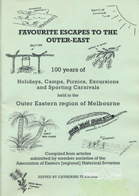
Book, Association of Eastern Historical Societies, Favourite Escapes to the Outer-East edited by Catherine Turnbull, 2002
Compiled from articles submitted by member societies of the Association of Eastern [regional] Historical Societies58 p. : ill. ; 30 cm.ISBN 0957788088lillydate, fern tree gully, yarra flats, gulf station, smiths gully, doncaster, narre warren, gembrook, eltham, blackburn lake, surrey hills, warrandyte, bayswater, yarra glen, queenstown, marysville, waverley, wonga park, bend of islands, dandenongs -
 Doncaster RSL Sub Branch
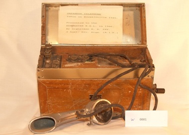
Japanese Bush telephone
... Roads Doncaster East melbourne Telephone taken on Bougainville ...Telephone taken on Bougainville 1945 used by Japanese signals Communications presentered to Doncaster RSL in 1986 by signalman R D Fry 3 Aust. div. Sigs. ( A.I.F.)Japanese Army bush telephone in container with manually operated generatormarked in japanese small label on front with number155420 -
 Doncaster RSL Sub Branch
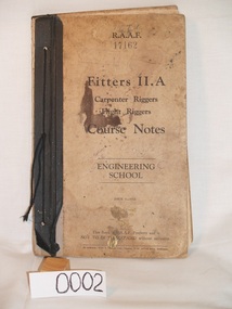
Foolscap Size Book, RAAF Course Notes. Fitters II.A Carpenters and Flight Riggers. Issue 5 - 1943
... Roads Doncaster East melbourne RAAF Engineering School World War ...RAAF Engineering School World War IIHard Cover Book. H) 330 x W) 205 x T)18. Dirty buff with black binding.RAAF Course Notes, Fitters II.A Carpenter Riggers Flight Riggers Engineering School Issue 5--1943 -
 Doncaster RSL Sub Branch
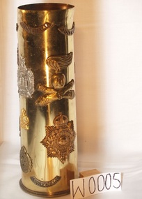
Shell Case, 18 Pound Shell Case, shell case marked 1940
... Roads Doncaster East melbourne Insignia; Royal Marines Epaulette ...Brass shell case with various insignia attachedInsignia; Royal Marines Epaulette;Royal Marines Gibralter; Kings Own Scotland Borderers;Royal Army Ordnance Corp;Australian Engineers; Australian Intelligence Corp;Tank Corp Badges;Australian Rising Sun Hat Badge AIF;Tunic Collar Badge AIF; Australian Epaulette AIF;Australian Artillery Hat Badge Perm Forces;Cross Cannons with No 70 Italian found in abandoned fort in North Africa1941;Eagle with spread wings Italian pound in abandoned fort North Africa