Showing 130 items matching " natural resources"
-
 Wodonga & District Historical Society Inc
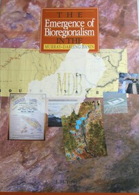
Book - The Emergence of Bioregionalism in the Murray-Darling Basin, Joseph Michael Powell, 1993
... conservation of natural resources.... conservation of natural resources A study of environmental policy ...A study of environmental policy and conservation issues in the Murray Darling Basin of Australianon-fictionA study of environmental policy and conservation issues in the Murray Darling Basin of Australiamurray-darling basin, environmental policy, murray-darling basin -- history., conservation of natural resources -
 Bendigo Historical Society Inc.
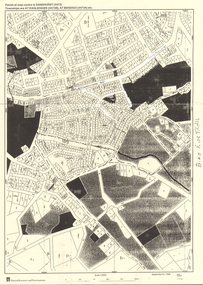
Map - LONG GULLY HISTORY GROUP COLLECTION: MAP - EAGLEHAWK ROAD
... Natural Resources and Environment... The Long Gully History Group - Map - Eaglehawk Road Natural ...BHS CollectionMap of part of Eaglehawk Road showing a Bike Ride Trail. Map is dated September 01, 1998, Scale 1:5000.bendigo, history, long gully history group, the long gully history group - map - eaglehawk road, natural resources and environment, bike ride trail -
 Bacchus Marsh & District Historical Society
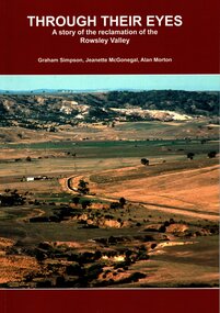
Book, Through Their Eyes : A Story of the Reclamation of the Rowsley Valley
... Conservation of Natural Resources... Environmental History Conservation of Natural Resources Aboriginal ...This book contains a collection of articles written by landholders, local residents and members of corporate and volunteer organisations describing their roles in the restoration of Rowsley Valley. The historical scope of this book encompasses the geological and environmental history of the area prior to human habitation, occupation by the Wadawurrung people prior to European colonisation, and the colonial and post colonial eras. This introductory contextual background is complemented by the rest of the book which describes the various aspects of the environmental restoration of the Rowsley Valley from the latter part of the 20th century continuing to the present day.Printed foolscap size book. Softcover. 112 pages. Colour and black and white photos. Maps, figures, tables. Index. Publication details. Graham Simpson (Publisher, Bacchus Marsh, Victoria, 2021. Lead authors Graham Simpson, Jeanette McGonegal and Alan Morton.This book contains a collection of articles written by landholders, local residents and members of corporate and volunteer organisations describing their roles in the restoration of Rowsley Valley. The historical scope of this book encompasses the geological and environmental history of the area prior to human habitation, occupation by the Wadawurrung people prior to European colonisation, and the colonial and post colonial eras. This introductory contextual background is complemented by the rest of the book which describes the various aspects of the environmental restoration of the Rowsley Valley from the latter part of the 20th century continuing to the present day.environmental restoration projects, rowsley valley victoria environmental history, conservation of natural resources, aboriginal australians bacchus marsh region history, wadawurrung people history -
 Glen Eira Historical Society
Article - Glen Eira Parks and Gardens
... Conservation of Natural Resources... Establishments Irrigation Water Conservation Conservation of Natural ...This file contains four items. 1/ An article in the Glen Eira News reporting on a new park with indigenous planting and an interpretive walk being developed to link Duncan McKinnon Reserve and Packer Park in Murrumbeena, dated September 2000. 2/ An article from the Glen Eira Leader on the converting of sports grounds from cool season to warm season grasses, as well as the installation of subsurface drip irrigation at Princes Park, Caulfield South, dated March 2012. 3/ An article from the Caulfield/Port Phillip leader reporting Caulfield RSL military historian Carl Johnson’s appeal to have a “lone pine” in Caulfield Park designated as a war memorial, dated 11/9/2012 4/ An article from the Glen Eira/Port Phillip Leader reporting on the Friends of Caulfield Park organising the first band stand concert in over twenty years with the City of Glen Eira Band, dated 6/11/2012glen eira council, hawthorn rd caulfield, glen eira rd caulfield, glen eira, caulfield, parks, reserves, leila rd caulfield, glen eira city council, landscaping, memorial park, kooyong rd caulfield north, caulfield recreation tennis club, murrumbeena rd caulfield, churchill green housing estate, north rd caulfield, boake street caulfield, exservices organisation, rsl clubs, sporting clubs, recreations, sportsgrounds, clubs, tennis clubs, associations, leisure, cultural events, cultural activities, sports establishments, recreations establishments, irrigation, water conservation, conservation of natural resources, water supply, ovals, playing fields, tennis courts, murrumbeena park, school concerts, musical activities, musical events, glen eira artists society, dimarco lisa, st. aloysius college, band rotundas, entertainment structures, musical ensembles, city of glen eira band, bands, the friends of caulfield park, gallipoli lone pine, princes park, packer park, duncan mckinnon reserve, king george reserve, caulfield park, glenhuntly park, glen huntly park, bentleigh reserve, victory park, schools, education establishments, recycling, water disposal, cultural structures, cultural establishments, caulfield rsl, johnson carl, war memorials, monuments, memorials, avenue of honour, “lone pine”, glen eira leader, glen eira news, caulfield/port phillip leader, glen eira leader -
Lakes Entrance Historical Society
Book, Land Conservation Council, Victoria, Final Recommendations East Gippsland Study Area 1977, 1977
... Natural Resources...Natural Resources Recreation Agriculture A summary ...A summary of the final recommendation for the adequate management and protection of public land in East Gippsland.natural resources, recreation, agriculture -
Lakes Entrance Historical Society
Book, East Gippsland Catchment Management, Regional Priorities for Catchment Management 1999-2000, 1999
... Natural Resources...Waterways Natural Resources Outline of the three major ...Outline of the three major strategic programs on which to focus long term actions and objectives for catchment management.waterways, natural resources -
Lakes Entrance Historical Society
Book, Parks Victoria Compiler, MacLeod Morass & Jones Bay Draft Management Plan 2003, 2003
... Natural Resources...Environment Fauna Natural Resources Restoration Vegetation ...A draft plan for the startegies to manage the Macleod Morass and Jones Bay Wildlife reservesenvironment, fauna, natural resources, restoration, vegetation -
Lakes Entrance Historical Society
Book, Land Conservation Council Victoria, The Gippsland Lakes Land Use Strategy Plan 1978, 1985
... , including natural resources, flora and fauna, recreation. Contains... of public land use in the East Gippsland area, including natural ...A review of public land use in the East Gippsland area, including natural resources, flora and fauna, recreation. Contains photographs, maps statistics.conservation, aboriginals, primary industry -
 Whitehorse Historical Society Inc.
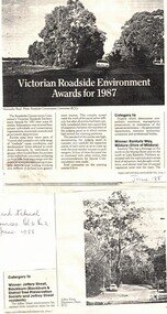
Article, Victorian Roadside Environment Awards for 1987, 1/06/1988 12:00:00 AM
... Article from 'Trees and Natural Resources' v.30 No2 (June... Article from 'Trees and Natural Resources' v.30 No2 (June 1988 ...Article from 'Trees and Natural Resources' v.30 No2 (June 1988) on Jeffrey Street, Blackburn, winner of Roadsides Conservation Committee's Victorian Roadside Environment Award for 1987.jeffery street, blackburn, roads and streets -
University of Melbourne, Burnley Campus Archives
Plan - Photocopy, Contour Map 1891, 1891
... of the garden design. From Central Plan Office Dept. of Natural... Plan Office Dept. of Natural Resources. Contour Map 1891 Plan ...Photocopy of plan showing contour lines from Yarra River. Shows Pavilion and Principal's Residence but not much of the garden design. From Central Plan Office Dept. of Natural Resources."Contour map 1891" written in biroyarra river, pavilion, burnley horticultural college, burnley gardens -
 Lakes Entrance Historical Society
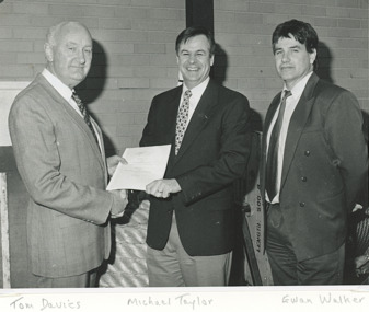
Photograph, Lakes Post Newspaper, management of Gippsland Ports Lakes Entrance Victoria, 1/09/1996 12:00:00 AM
... to Gippsland Ports from Michael Taylor permanent secretary for Natural... Ports from Michael Taylor permanent secretary for Natural ...Black and white photograph showing handover of management to Gippsland Ports from Michael Taylor permanent secretary for Natural Resources to Tom Davies and Ewan Walker of Gippsland Ports at Lakes Entrance Victoriagovernment services, gippsland ports, port authority -
Lakes Entrance Historical Society
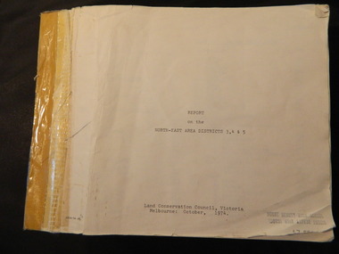
Book, Land Conservation Council Victoria East Gippsland Study Area, 1974
... , together with the character and distribution of various natural... and distribution of various natural resources of the East Gippsland ...Report describing the nature of environmental features, together with the character and distribution of various natural resources of the East Gippsland, Victoria, study area, comprising land in the old Shire of Orbost. History, vegetation, flora, fauna,vegetation, natural history, vegetation -
Lakes Entrance Historical Society
Book, Land Conservation Council Victoria South Gippsland Area District 2, 1980
... Report describing and assessing the natural resources... Report describing and assessing the natural resources ...Report describing and assessing the natural resources of the public land in the South Gippsland (Victoria) Study Area 2, comprising the Latrobe Valley, Strzelecki Range, South Gippsland coastal plains and all of Wilson's Promontory. History, Geology, floRuth Clarkgippsland, topography, natural history, vegetation -
Federation University Historical Collection
Report, Read Sturgess and Associates Consulting Economists et al, The Economic Significance of Grampians National Park, 1994 (and other reports), 1990-4
... and Natural Resources, 1994... for the Department of Conservation and Natural Resources, 1994 The Economic ....1) Grampians Surround Strategy, 1990 .2) Tourism and the Grampians Region: A Background Paper, 1990 .3) Grampians Surround Strategy and Discussion Paper, 1991 .4) The Economic Significance of Grampians National Park for the Department of Conservation and Natural Resources, 1994Notes in pencil by Mary Hollick, lecturer in Tourism at the University of Ballarat.victorian tourisim industry, tourism, halls gap, grampians, grampians national park, recreation, water production, bee keeping, arapiles, dunkeld, balmoral, pomonal, wartook, population, agriculture, water supplies, minerals, hamilton, ararat, stawell, horsham, wimmera, koorie heritage, aboriginal heritage, koorie art sites, brambuk, waterways, wannon river, wimmera river, mount william creek, rocklands reservoir, lake lonsdale, lake fyans, lake toolando, cherrypool, mirranatwa, zumstein -
 Greensborough Historical Society
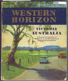
Book, Australian Publicity Council, The Western horizon of Victoria Australia, 1960c
... A pictorial presentation of the natural resources... of the natural resources and development of agriculture and industry ...A glossy publicity publication for the state of Victoria.111 p., illus. (some col.), maps.non-fictionA glossy publicity publication for the state of Victoria.victoria - history, western district (vic.), melbourne - history -
 Marysville & District Historical Society
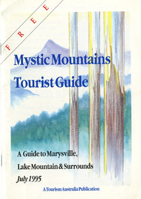
Ephemera (Item) - Tourist Guide, Graeme Haycraft, Mystic Mountains Tourist Guide July 1995, 07-1995
... , Marysville Office of the Dept. of Conser/ vation & Natural Resources..., Marysville Office of the Dept. of Conser/ vation & Natural Resources ...A tourist guide outlining services, accommodation, activities and places of interest to visit in and around Marysville, Lake Mountain and the local district.A tourist guide outlining services, accommodation, activities and places of interest to visit in and around Marysville, Lake Mountain and the local district.Acknowledgements/ Mystic Mountains Tourism Association, Marysville Office of the Dept. of Conser/ vation & Natural Resources, Mrs Elaine Postlethwaite, Ms Sue Henry & every/ advertiser without whose support this Guide would not have been possible.marysville, victoria, australia, tourist guide, mystic mountains, lake mountain, tourism australia, graeme haycraft, magic creek nursery, missing links miniature golf, phelps bakery, blackwood cottages, marysville hotel motel, tower motel, kerami house, marylands guest house, lomatia lodge, willowbank at taggerty, barree mud brick cottages, scenic motel, somerled mountain retreat, dalrymples guest cottages, nanda binya lodge, mathilde's of marysville country guest house, the birches resort, mystic mountains tourist information, marysville caravan park, the cumberland, igloo roadhouse, top shop pancake parlour, the silver birch restaurant, steavenson's restaurant, olde yarra track shoppe, danish coffee gardens, oscars take-away, country touch pottery studio & gallery, cumberland memorial scenic reserve, cathedral range state park, lady talbot forest drive, wishing well, taggerty river picnic area, taggerty river, phantom falls, keppels falls, the beeches walking track, mount sugarloaf, maryton park holiday cottages, snowviews, esa camping & conference centre, wirreanda festival, marysville post shop, hidden talent craft gallery, marysville automotive repairs, geoffrey pope & associates, beauty spot walk, tree fern gully walk, michaeldene track, marysville riding school, gerraty's ski centre, marysville holiday cottages, marysville triangle taxi service, fruit salad farm, lake mountain alpine resort, marysville ski hire, lake mountain ski school, cross country ski hire, lake mountain ski hire, marysville country club -
 Marysville & District Historical Society
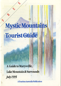
Ephemera (Item) - Tourist Guide, Graeme Haycraft, Mystic Mountains Tourist Guide July 1995, 07-1995
... , Marysville Office of the Dept. of Conser/ vation & Natural Resources..., Marysville Office of the Dept. of Conser/ vation & Natural Resources ...A tourist guide outlining services, accommodation, activities and places of interest to visit in and around Marysville, Lake Mountain and the local district.A tourist guide outlining services, accommodation, activities and places of interest to visit in and around Marysville, Lake Mountain and the local district.Acknowledgements/ Mystic Mountains Tourism Association, Marysville Office of the Dept. of Conser/ vation & Natural Resources, Mrs Elaine Postlethwaite, Ms Sue Henry & every/ advertiser without whose support this Guide would not have been possible.marysville, victoria, australia, tourist guide, mystic mountains, lake mountain, tourism australia, graeme haycraft, magic creek nursery, missing links miniature golf, phelps bakery, blackwood cottages, marysville hotel motel, tower motel, kerami house, marylands guest house, lomatia lodge, willowbank at taggerty, barree mud brick cottages, scenic motel, somerled mountain retreat, dalrymples guest cottages, nanda binya lodge, mathilde's of marysville country guest house, the birches resort, mystic mountains tourist information, marysville caravan park, the cumberland, igloo roadhouse, top shop pancake parlour, the silver birch restaurant, steavenson's restaurant, olde yarra track shoppe, danish coffee gardens, oscars take-away, country touch pottery studio & gallery, cumberland memorial scenic reserve, cathedral range state park, lady talbot forest drive, wishing well, taggerty river picnic area, taggerty river, phantom falls, keppels falls, the beeches walking track, mount sugarloaf, maryton park holiday cottages, snowviews, esa camping & conference centre, wirreanda festival, marysville post shop, hidden talent craft gallery, marysville automotive repairs, geoffrey pope & associates, beauty spot walk, tree fern gully walk, michaeldene track, marysville riding school, gerraty's ski centre, marysville holiday cottages, marysville triangle taxi service, fruit salad farm, lake mountain alpine resort, marysville ski hire, lake mountain ski school, cross country ski hire, lake mountain ski hire, marysville country club -
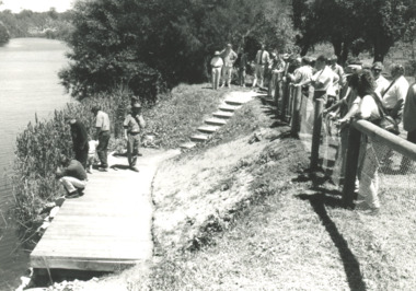 Lakes Entrance Historical Society
Photograph, fishing platform , Tambo River Victoria, 1/11/1994 12:00:00 AM
... and Department of Natural Resources and Environment on the bank... by Tambo Nicholson Management Group and Department of Natural ...Black and white photograph showing crowd gathered at launch of the fishing platform installed by Tambo Nicholson Management Group and Department of Natural Resources and Environment on the bank of the Tambo River Victoria. Also three other black and white photographs showing the TAFE students under LEAP program building the fishing platform. birds, fishing, jetties -
Glenelg Shire Council Cultural Collection
Geological specimen - Whale bones, n.d
... Believed to be confiscated by Department of Natural... to be confiscated by Department of Natural Resources from members ...Believed to be confiscated by Department of Natural Resources from members of the public who had the bones in violation of the law. | 19/4/2000Various whale bones including |1 x top skull bone of Southern Right Whale |1 x jaw bone |1 x vertebrae |1 x rib |1 x eardrum -
 University of Melbourne, Burnley Campus Archives
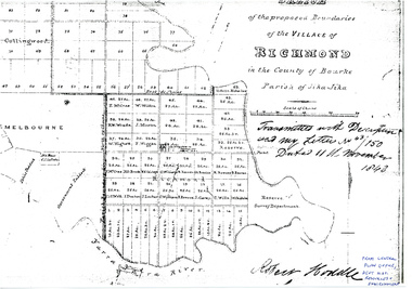
Plan - Photocopy, Sketch of the Proposed Boundaries of the Village of Richmond, 1843
... Office, Department of Natural Resources and Environment... Office, Department of Natural Resources and Environment Sketch ...Sketch of the proposed boundaries of the village of Richmond in the County of Bourke Parish of Jika-Jika. Handwritten on original: "Transmitted with Description and my letter No 43/150 Dated 11th November 1843 Robert Hoddle." Shows Burnley Gardens site as "Reserve. Survey Department." original in Central Plan Office, Department of Natural Resources and EnvironmentIn ink: From Central Plan Office Dept. Nat. Resources & Environmentrichmond, jika-jika, survey department, yarra river, robert hoddle -
Glenelg Shire Council Cultural Collection
Animal specimen - Whale bone, Whale Bones, n.d
... Placed in custody of M.H.A.C. by the Department of Natural... of M.H.A.C. by the Department of Natural Resources. See Charlie ...Placed in custody of M.H.A.C. by the Department of Natural Resources. See Charlie Cooper - believed that the items were confiscated from the public who have violated the law.Whale Bones. Approx 25 various types and sizes. 1 Jaw bone Right Whale skull, vertebrae. -
University of Melbourne, Burnley Campus Archives
Nursery catalogues, Nursery Catalogues: booklets & foolscap sheets
... Lodge Nursery; Cowley Nurseries; Natural Resources Conservation... Nurseries; Natural Resources Conservation League Victoria; Forests ...nurseries, plant nomenclaturenurseries, plant nomenclature -
Federation University Historical Collection
Map - Map - Geological, Kejimkujik Lake, Nova Scotia: Geological Map 94-05, 1994
... Produced by Nova Scotia Department of Natural Resources... Produced by Nova Scotia Department of Natural Resources, Mines ...Produced by Nova Scotia Department of Natural Resources, Mines and Energy Branches. The Minister of the Department was the Honourable Donald R Downe and the Deputy Minister was Darrell D HiltzLarge coloured map depicting different areas and deposits. Includes a legend, symbols used, mineral abbreviations and alteration abbreviations.Symbolskejimkujik lake, nova scotia -
 Otway Districts Historical Society
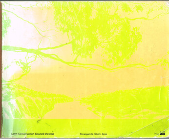
Book, Land Conservation Council, Report on the Corangamite Study Area, May 1976
... The Report describes and assesses the natural resources... the natural resources of public land in the Corangamite study area ...The Report describes and assesses the natural resources of public land in the Corangamite study area, and provides a factual basis on which members of the community may base their submissions to the Council.Report on the Corangamite study area. Land Conservation Council. Melbourne; Land Conservation Council; May 1976. x, 310 p.; illus, maps (separate). Soft cover.land conservation council; corangamite; geology; physiography; climate; water resources; soils; vegetation; fauna; -
 Bendigo Historical Society Inc.
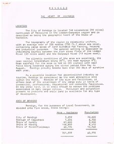
Document - BENDIGO - THE HEART OF VICTORIA
... , Industrial Base, natural Resources, Agriculture and Livestock... of Bendigo, The People, Work Force, Industrial Base, natural ...Typed article titled Bendigo, The Heart of Victoria. Items mentioned are Location, Area of Bendigo, The People, Work Force, Industrial Base, natural Resources, Agriculture and Livestock, Minerals, Forests, Rail and Road, Sea and Air, Power and Water, Electricity, Natural Gas, Water, Sewerage, Industrial Land, Services, Community Services and Facilities, Educational Facilities, Hospitals, Culture and Tourism and Media.document, bendigo - the heart of victoria, city of bendigo, borough of eaglehawk, shire of huntly, shire of marong, shire of strathfieldsaye, bendigo development committee, department of agriculture, department of state development decentralization and tourism, state electricity commission, gas & fuel corporation of victoria, state rivers & water supply commission, bendigo sewerage authority, the bendigo college of advanced education, home and hospital for the aged, home for the blind, northern school of nursing, art gallery, historical society, dudley house, sun loong, central deborah gold mine, the vintage talking trams and transport museum, bcv8, the bendigo advertiser, golden city gazette, 3bo, 3cv, mr a j kelly -
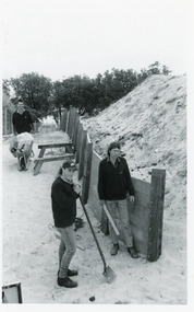 Lakes Entrance Historical Society
Photograph, Lakes Post Newspaper, 1992
... the Department of Conservation and Natural Resources, (L-R) Ken Judd... the Department of Conservation and Natural Resources, (L-R) Ken Judd ...Article appeared in Lakes Post 28 October 1992, 'At work on the new retaining wall leading to 90 Mile Beach, staff from the Department of Conservation and Natural Resources, (L-R) Ken Judd, Jason Bice and David Harper'.Black and white photograph of three workers, building pathway and retaining walls through the sand dunes. Coastal banksia in background. Lakes Entrance Victoriawaterfront, parks, room display -
Kew Historical Society Inc
Archive (series) - Subject File, McDonalds (Fast Food Restaurant)
... Tribunal, and the Department of Conservation and Natural Resources... Tribunal, and the Department of Conservation and Natural Resources ...Kew Historical SocietySince its foundation in 1958, members of the Kew Historical Society have been compiling and storing information about subjects relating to the history of Kew and its environs, of which this file is an example. Arranged by Secondary Values (value of records to users)Subject file created by researchers of the Kew Historical Society containing information about the McDonald's fast food franchise in High Street, Kew. The file contains a number of primary and secondary sources including newspaper cuttings, planning objections, correspondence between KHS, the City of Kew, the Administrative Appeals Tribunal, and the Department of Conservation and Natural Resources etc. The file also includes copies of the plans for the proposed restaurant. mcdonalds fast food franchises, mcdonalds restaurant -- kew (vic.), administrative affairs tribunalmcdonalds fast food franchises, mcdonalds restaurant -- kew (vic.), administrative affairs tribunal -
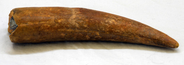 Orbost & District Historical Society
fossil
... identification came from Andy Murray - Conservation & Natural Resources... identification came from Andy Murray - Conservation & Natural Resources ...This fossil was found by Peter Cook just west of East Cape at Cape Conran (east of Orbost),. Original correspondence re its identification came from Andy Murray - Conservation & Natural Resources, Orbost. It was on display at the Orbost Visitor Information Centre - the Slab Hut.A fossil tooth from a marine species. It may be from a an extinct ziphiid or beaked whale (Warneke Marine Mammal Services 20.10.1993). It may be a fossil from a large species of subadult seal (Ewan Fordyce Senior Lecturer in Geology, University of Otago 11.10.1993).fossil-tooth whale seal marine cape-conran -
 Kiewa Valley Historical Society
Report - Land Conservation Council x2, Land Conservation Council, Victoria Melbourne, April 1978, October 1974
... of public land in Victoria. It describes and assesses the natural... in Victoria. It describes and assesses the natural resources ...Land Conservation Act 1970 established the Land Conservation Council to investigate and recommend to the Minister use of public land in Victoria. It describes and assesses the natural resources:-Physiography, Geology, Topography, Land Systems, Outdoor Recreation, Public land and blocks. Primary Production. Vegetation.North East Victoria includes the Kiewa Valley. This report gives an understanding of the development of the area.Thick heavy book with 312 pages with black and white photos. Back half has a folder with heavy cardboard attached to thick cardboard back cover. Inside folder are 9 maps with color each with a different title.Stamped on Front Cover: "Mount Beauty High School" Has a library borrowing slip at the back of the last page.land conservation council, environment, public land, kiewa valley, planning -
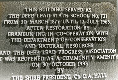 Stawell Historical Society Inc
Photograph, Deep Lead Dedication Plaque
... ad Natural Resources and the Deep Lead Progress Association... with the Department of Conservation ad Natural Resources and the Deep Lead ...B/W Photp Bronze PlaqueThe Building served as the Deep Lead State School No. 721 from 30 March 1877 Until 12 July 1963. After Restoration by Brambuk Inc. In Co-operation with the Department of Conservation ad Natural Resources and the Deep Lead Progress Association it was reopened as a Community Amenity on 30 October 1993.'By the Shire President Cr. C.A. Hall.deep lead school, education