Showing 153 items
matching production of mines
-
 Bendigo Historical Society Inc.
Document - NEW BENDIGO GOLD PROJECT: REPORT ON BENDIGO HISTORICAL GOLD PRODUCTION
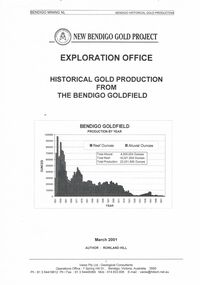
New Bendigo Gold Project -Bendigo Mining NL - Report on Bendigo Historical Gold Production from the Bendigo Goldfield -Exploration Office - dated March 2001 . Paper presented by Rowland Hill, Bendigo Mining NL, at BHS meeting, 2 November, 2001. 30 pages.document, gold, gold mines of bendigo & eaglehawk -
 Bendigo Historical Society Inc.
Document - LONG GULLY HISTORY GROUP COLLECTION: NEW CHUM REEF MINE STATS
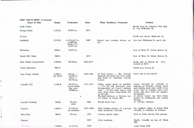
... is the name of Mine, Depth, Production, Dates, Plant, Machinery... (Continued). Listed is the name of Mine, Depth, Production, Dates ...Copy of a page titled New Chum Reef (Continued). Listed is the name of Mine, Depth, Production, Dates, Plant, Machinery, Comments and Position. Mines listed are:- Little Chum, Young Chum, Craven, Garibaldi, Ellesmere, South Old Chum, New Chum Consolidated, North Ellesmere, New Chum United, Abraham Lincoln Battery, Lansell's 222, Fortuna Battery, Lansell's Fortuna, Lazarus, Lazarus, West End and Pioneer,bendigo, history, long gully history group, the long gully history group - new chum reef mine stats, little chum, young chum, craven, garibaldi, ellesmere, south old chum, new chum consolidated, north ellesmere, new chum united, mt alvernia hospital, abraham lincoln battery, lansell's 222, fortuna battery, fortuna, private tunnel, lansell's fortuna, lunt, lazarus, chum hill, lazarus, west end, army survey unit, pioneer -
 Bendigo Historical Society Inc.
Photograph - EXTENDED HUSTLERS FREEHOLD
black and white photograph of Great Extended Hustlers Freehold poppet head, now at Wattle Gully, Chewton ( james Lerk 26.22.1999 ) Poppet head in front of mining buildings, stacks of sawn timber tonight. Great Extended Hustlers/locality/Hustlers Hill Nth. Bendigo/ formed 1865/last production 1921. Depth of shaft 3,470 ( 1045 m ) Poppet legs, steel 70 feet high ( 21.08 ) Gold very rich, total yield 300,000 ozs. Dividends 675,000 pounds sterling ( $1,350,000 )organization, business, great extended hustlers mine -
 Bendigo Historical Society Inc.
Photograph - GREAT EXTENDED HUSTLERS MINE
black and white postcard. Great extended Hustlers poppet head, now at Wattle Gully, Chewton ( J. Lerk 26.22.1999 ) Poppet head in front of mining buildings, stacks of sawn timber to right. Written on back ' Royal Historical Society of Victoria Bendigo Branch, printed across top. Great Extended Hustlers/locality/ Hustlers Hill, Nth. Bendigo/Formed 1865/Last production 1921/Depth of Shaft 3470 feet/Poppet Legs - Steel, 70 feet high. /Winding Engine: First motion 8 ft. drums/Gold Very Rich/Total Yield - 300,000 ozs. / Dividends $675,000. 'Post Card' printed on RH side.organization, business, great extended hustlers mine -
 Bendigo Historical Society Inc.
Document - MINING REPORTS - LANSELL'S BIG 180
Partial page of handwritten notes on Lansell's Big 180 Mine on the New Chum Line. Notes give detailed location of the shaft, when it was formed and last production in 1916. Also some notes on the poppet legs.document, gold, mining reports, mining reports, lansell's big 180, john brown knitwear factory, caleb thomas -
 Bendigo Historical Society Inc.
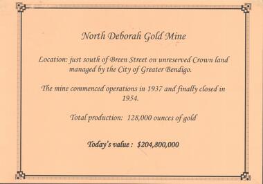
Photograph - NORTH DEBORAH GOLD MINE
Display interpretive sign for North Deborah Gold Mine. Mine located just south of Breen Street. Commenced operations in 1937 and closed in 1954. Total production 128,000 ounces of gold.Kay MacGregor, Bendigo Historical Societybendigo, mining, north deborah gold mine -
 Bendigo Historical Society Inc.
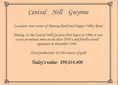
Document - CENTRAL NELL GWYNNE GOLD MINE
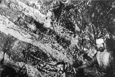
Interpretive sign and 4 photos Central Nell Gwynne Gold Mine, used in display. Central Nell Gwynne was located near the corner of Marong Road and Happy Valley Road. Opened in 1906, ceased operation in December 1949. Total production: 61,884 ounces of Gold. Today's Value: $99,014,400. Photos: a. Colour photo, concrete footings at mine site, April 2012. b. Colour photo, Central Nell Gwynne poppet head, April 2012.Poppet head painted white with red trim. Concrete footings in foreround. c. Central Nell Gwynne mine site 1930's. Poppet head and engine room sheds on LH side, trestle way to primary crusher and crushing battery. Tailing dam in immediate foreground. on RH side. Sand heaps in middle foreground. d. Central Nell Gwynne Mine 1930. Underground view, men holding carbide lamps working at 265 level in mine. Large quartz spur formation visible in foreground.bendigo, mining, central nell gwynne -
 Bendigo Historical Society Inc.
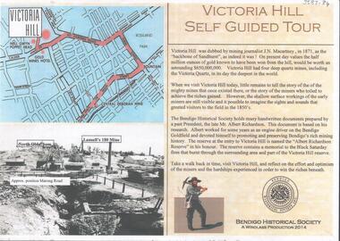
Document - VICTORIA HILL SELF GUIDED TOUR 2014
Two page document prepared for the 2014 centenary of the mine disaster at the Great Extended Hustlers Mine, where 7 miners were killed in 1914. Document titled 'Victoria Hill, Self Guided Tour' prepared by Philip Wilkin and Kay MacGregor (Windlass Production 2014) The guided tour document was made available at the commemorative event held at the Hustler's Hill Reserve.bendigo, mining, victoria hill guided tour -
 Bendigo Historical Society Inc.
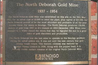
Photograph - NORTH DEBORAH GOLD MINE BENDIGO MINING PLAQUE
Metal plaque, gold writing, erected at the site of the former North Deborah Gold Mine when the brick chimney was restored by Bendigo Mining NL. The plaque reads: 'The North Deborah Gold Mine, 1937-1954. The North Deborah Gold mine was established on this site on the 28th May 1937. For an initial cost of 2,000 pounds to erect the plant, plus capital of 37,500 pounds, the North Debnorah proved to be the most abundant and profitable of all the post Second War mines in Bendigo. The North Deborah produced 128,000 ounces of gold from 1937 to its closure on 23rd December 1954. When mine manager E.J. White closed the doors that day he signaled the end to a great story of gold discovery and production. The North Deborah was the last mine to operate on the Bendigo goldfield during the initial golden era. It was not until the new century that gold mining would return. This historic chimney was restored by Bendigo Mining Limited in 2006. Along with the poppet head. It is the only visible surface remains of the original North Deborah Mine.' The mine site is situated off Breen Street in Golden Square.Kay MacGregor 2012bendigo, mining, north deborah mining company -
 Bendigo Historical Society Inc.
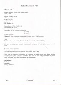
Document - GOLDEN CARSHALTON MINE - NOTES ON THE GOLDEN CARSHALTON MINE
Hand written notes by Albert Richardson in red on the Golden Carshalton Mine and the Forbes Carshalton Mine. Golden Carshalton Mine was formerly called the Carshalton B. M. L. Shaft. Notes include location, depth, mining methods, gold production. Ref: M. D., Chambers & Bendigo Advertiser.mine, gold, golden carshalton mine, golden carshalton mine, carshalton b. m. l. shaft, gold production, forbes carshalton, m. d., chambers, bendigo advertiser, derby & carshalton coy., carshalton no 2 shaft -
 Bendigo Historical Society Inc.
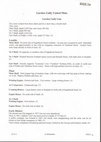
Document - GARDEN GULLY UNITED MINE - NOTES ON THE GARDEN GULLY UNITED MINE
... mine, gold production, references on typed copies. One typed... Shaft Rainbow Shaft gold production leading mine Pandora Reef ...One hand written and four typed copies of notes on the Garden Gully United Mine and a spare last typed page. Notes include depth of shafts, locality, early history,plant, leading mine, gold production, references on typed copies. One typed copy, with Typed at Mines Dep't written at the top has a number of corrections/inclusions and a hand drawn locality map attached to the back.mine, gold, garden gully united mine, garden gully united mine, garden gully line of reef, paddy's gully line, economic now crestknit knitting mills, roberts & sons, ladam's reef, tribute companies, possum shaft, rainbow shaft, gold production, leading mine, pandora reef, rosalind park, dr h l atkinson, i e dyason, w hunter, g lansell, e mueller, bendigo amalgamated company, bendigo city council, w h taylor, mines dept booklet 'bendigo goldfields' geo brown 1936, annals of bendigo 1873 & 1874, annals of bendigo dividend records from 1873 to 1935, a richardson, bendigo minicipal library booklet 'healthy golden bendigo' -
 Bendigo Historical Society Inc.
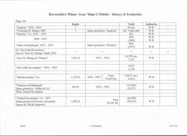
Document - DEVONSHIRE MINES - DEVONSHIRE MINES PRODUCTION
... and authority. Document DEVONSHIRE MINES - DEVONSHIRE MINES PRODUCTION ...Hand written notes on Devonshire Mines mentioning name of mine, years of operating, depth, yield and authority.mine, gold, devonshire mines, devonshire mines, bendigo goldfields - history & production, surprise, victorian st mungo, mystery co, duke of edinburgh, gt ext'd sth devonshire, new st mungo shaft, new st mungo, ext'd sth devonshire, sth devonshire co, duchess of edinburgh, albert & coy, west united devonshire, united devonshire co, princess alexandria, saxon & celt & hopewell -
 Bendigo Historical Society Inc.
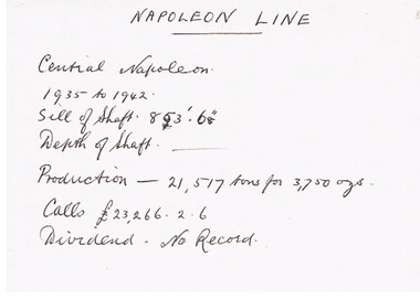
Document - CENTRAL NAPOLEON MINE - NOTES ON CENTRAL NAPOLEON MINE
Hand written notes on cream paper. Years from 1935 to1942. Lists the Sill of Shaft depth, Production and Calls.mine, gold, central napoleon mine, central napoleon mine, napoleon line -
 Bendigo Historical Society Inc.
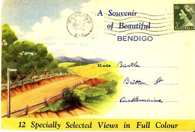
Photograph - SOUVENIR FOLDER OF BENDIGO VIEWS
Twelve photographic views of Bendigo posted 1955. Pall Mall, Law courts & Conservatory Gardens, St Andrews Church Spire, Overlooking Bendigo, Charing Cross, Interior of Conservatory, Overlooking Bendigo, Baths & Park, Gardens & Post Office, Above ground gold mine, Rosalind Park.Nucolorvue Productions Mentone Vicbendigo, buildings, heritage buildings -
 Bendigo Historical Society Inc.
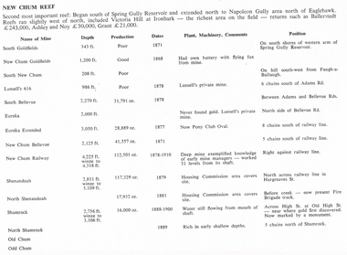
Document - LONG GULLY HISTORY GROUP COLLECTION: NEW CHUM REEF
... with the Name of Mine; Depth; Production; Dates; Plant, Machinery... mines. The mines are mentioned in a table with the Name of Mine ...Six pages titled New Chum Reef. No number on the first page, the others are 109 to 113. Mentions location of the reef and some of the rich mines. The mines are mentioned in a table with the Name of Mine; Depth; Production; Dates; Plant, Machinery, Comments and Position. Ballerstedt, Ashley and Noy, and Grant were three of the successful miners. Mines mentioned are: South Goldfields, New Chum Goldfields, South New Chum, Lansell's 616, South Bellevue, Eureka, Eureka Extended, New Chum Bellevue, New chum Railway, Shenandoah, North Shenandoah, Shamrock, Old Chum, Little Chum, Young Chum, Craven, Garibaldi, Ellesmere, South Old Chum, New Chum Consolidated, North Ellesmere, New Chum United, Lansell's 222, Lansell's Fortuna, Lazarus, West End, Pioneer, Old Chum, New Chum Victoria, North Old Chum, Lansell's Big 180, Sterry, Victoria Quartz, South Adventure, Great Central Victoria, Ballerstedt No 3, Adventure, Humbold, British and American, Midway, Victoria Consuls, Victoria absorbed by Ironbark, Hercules and Energetic, Victoria Pilot, North Hercules and Energetic, Great Extended Hercules, Pearl, Southern Victoria, Great Extended Victoria, Young Victoria, New Catherine Victoria, Weatern Victoria, New Victoria St Mungo, Surprise, Mystery, Duke of Edinburgh, New St Mungo, Duchess Tribute, South Devonshire, Duchess of Edinburgh, West United Devonshire, Albert, United Devonshire, Saxon and Celt, Hopewell, Prince of Wales, Phoenix, Unicorn, South St Mungo, Princess Alice, Lady Barkly, North Devonshire, Ranzeau, St Mungo, Dublin and Cornwall, Sadowa, Eastwood, Ellenborough, Belmont and Saxeby, Snobs Hill, York and Durham, La bElle, Old Williams United, Arcadia, Williams United, South Catherine, Central Catherine, Catherine United, Murchison, New Franklin, Catherine Extended, Pony Club Oval, Housing Commission, Mt Alvernia Hospital, Fortuna, Lunt, Army Survey Unit, Wybrandt, John Brown Factory, Canterbury, Hercules and Energetic and the North Red White and Blue.bendigo, history, long gully history group, the long gully history group - new chum reef, ballerstedt, ashley and noy, grant, south goldfields, new chum goldfields, south new chum, lansell's 616, south bellevue, eureka, eureka extended, new chum bellevue, new chum railway, shenandoah, north shenandoah, shamrock, old chum, little chum, young chum, craven, garibaldi, ellesmere, south old chum, new chum consolidated, north ellesmere, new chum united, lansell's 222, lansell's fortuna, lazarus, west end, pioneer, old chum, new chum victoria, north old chum, lansell's big 180, sterry, victoria quartz, south adventure, great central victoria, ballerstedt no 3, adventure, humbold, british and american, midway, victoria consuls, victoria absorbed by ironbark, hercules and energetic, victoria pilot, north hercules and energetic, great extended hercules, pearl, southern victoria, great extended victoria, young victoria, new catherine victoria, weatern victoria, new victoria st mungo, surprise, mystery, duke of edinburgh, new st mungo, duchess tribute, south devonshire, duchess of edinburgh, west united devonshire, albert, united devonshire, saxon and celt, hopewell, prince of wales, phoenix, unicorn, south st mungo, princess alice, lady barkly, north devonshire, ranzeau, st mungo, dublin and cornwall, sadowa, eastwood, ellenborough, belmont and saxeby, snobs hill, york and durham, la belle, old williams united, arcadia, williams united, south catherine, central catherine, catherine united, murchison, new franklin, catherine extended, pony club oval, housing commission, mt alvernia hospital, fortuna, lunt, army survey unit, wybrandt, john brown factory, canterbury, hercules and energetic, north red white and blue -
 Bendigo Historical Society Inc.
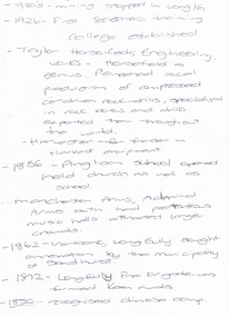
Document - LONG GULLY HISTORY GROUP COLLECTION: 1852 - 1950'S
Two hand written pages with year dates and what took place at that time. Dates range from 1852 to 1950's. 1950's - mining stopped in Long /G. 1926 - First Teachers training College established. Taylor Horsefields Engineering works - Horsefield a genius. Pioneered local production of compressed air driven roak-drills, specialized in rock bores and drills exported them throughout the world. Harvester - for f/ter in Harvest equipment. 1856 - Anglican School opened held church as well as school. Manchester Arms, Admiral Arms both has pretentious music halls attracted large crowds. 1862 - Ironbark, Long Gully sought annexation by the Municipality of Sandhurst. 1872 - Long Gully Fire Brigade was formed. Keen rivals. 1850 - recognised Chinese camp. ? Long Gully - due to the sinking deeper and the rewards generally richer, became the heart of 'Little Cornwall' - Cornish people. * Tent Church services held in 1862. Long Gully Mine opened April 1852. On the back of the first page is written - Mines - Reefs. mines mentioned are New Chum Hill, the New Chum and Victoria, The Victoria HIll Ironbark, The North Old Chum, Lansell's Big 180, Ballerstadt's Open-Cut, and the Victoria Quartz Mine.bendigo, history, long gully history group, the long gully history group - 1852 to 1950's, first teachers training college, taylor horsefields engineering works, anglican school, manchester arms, admiral arms, municipality of sandhurst, long gully fire brigade, chinese camp, little cornwell, long gully mine -
 Bendigo Historical Society Inc.
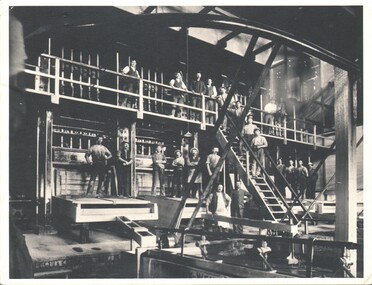
Photograph - WES HARRY COLLECTION: STAMPING BATTERY, 1880's ?
Photograph of the interior of a stamping battery from an unknown mine, there are twenty three men posed in various locations, some are in front of the battery boxes, a central stairway and some are on a balconybuildings, commercial, stamping battery, stamping battery, gold production -
 Bendigo Historical Society Inc.
Document - MCCOLL, RANKIN AND STANISTREET COLLECTION: NORTH DEBORAH GOLD MINE NL. GOLD PRODUCTION, 1951 - 1954
... GOLD MINE NL. GOLD PRODUCTION... AND STANISTREET COLLECTION: NORTH DEBORAH GOLD MINE NL. GOLD PRODUCTION ...Document: MCCOLL, RANKIN AND STANISTREET, gold production book. Green cover with ruled pages showing fortnightly gold production values from 17 May 1951 to 14 December 1954. Written inside front cover ' North Deborah Mining Co. NL, gold producers association Reg. No. 235. Gold Book No. 3'organization, mining, mccoll, rankin and stanistreet, mccoll, rankin and stanistreet, north deborah gold mine nl, goldmining, mining, gold production -
 Bendigo Historical Society Inc.
Document - MCCOLL, RANKIN AND STANISTREET COLLECTION: NORTH DEBORAH GOLD MINE NL, 1944 - 1957
... AND STANISTREET North Deborah Gold Mine NL goldmining gold production ...Document: MCCOLL, RANKIN AND STANISTREET, gold production book. Green covered book. Written inside front cover 'North Deborah Mining Co. NL' Ruled pages with values of fortnightly gold production. From 14 December 1944 to 3 May 1957.organization, mining, mccoll, rankin and stanistreet, mccoll, rankin and stanistreet, north deborah gold mine nl, goldmining, gold production -
 Bendigo Historical Society Inc.
Book - MCCOLL, RANKIN AND STANISTREET COLLECTION: NORTH DEBORAH GOLD MINE NL PRODUCTION, 1944 - 1954
... GOLD MINE NL PRODUCTION... AND STANISTREET North Deborah Gold Mine NL goldmining gold production Book ...Book: North Deborah Gold Mine gold book. Brown covered book written in black ink on front cover ' North Deborah GM NL No 1, from 3rd. May 1939 to 30 November 1944. Book contains ruled pages with values of fortnightly gold production.organization, mining, mccoll, rankin and stanistreet, mccoll, rankin and stanistreet, north deborah gold mine nl, goldmining, gold production -
 Victorian Interpretive Projects Inc.
Book, Theodore Jesse Hoover, The Economics of Mining, 1938
Theodore Jesse Hoover, brother of the 31st President of the United States, was born in West Branch, Iowa, on January 28, 1871. He attended Stanford and received the Bachelor of Arts degree in Geology and Mining in 1901. Following graduation his professional career started with the position of assayer for the Keystone Consolidated Mining Company. After one year, he became assistant manager for the Standard Consolidated Mine, and a year later he was promoted to manager of the operation. In 1907 Hoover went to London as general manager of Minerals Separation, Ltd. This company was developing the froth flotation process for recovering minerals from ores. Hoover took an active part in the development of the flotation concentration process and authored one of the first books on the concentration of ores by flotation. After four years with Minerals Separation, Ltd., Hoover entered private practice as a consulting mining and metallurgical engineer with offices in London and in San Francisco. He was very successful and held positions of consulting engineer, managing director, director, and president of many mining companies in America, Europe, Asia, Africa, and Australia. He returned to Stanford in 1919 as Professor of Mining and Metallurgy and Executive Head of the Department of Mining and Metallurgy. His experience and ability in organization made him a natural leader. He was influential in the formation of the School of Engineering at Stanford. The School was formed in 1925 and he was made dean, a position he held until his retirement in 1936. As dean of engineering, he promoted a broad fundamental training program for undergraduate engineering students. Under his guidance, emphasis was placed upon graduate work and he was responsible for developing strong graduate engineering curricula at Stanford. While dean he continued teaching and his course, "The Economics of Mining," developed into a book which was published in 1933. He became interested in the functions of engineers and, with Professor Fish, wrote a book entitled "The Engineering Profession" which was published in 1940 and revised in 1950. In addition to his academic activities he was generous in his hospitality. Faculty and students alike enjoyed the annual field day and barbecue at his Rancho del Oso, near Santa Cruz. He was widely read and had a lively interest in all the things he encountered. He speculated on the antiquity of man and man's early production processes. To verify an idea regarding flint tools, he studied their shapes and became proficient in making arrow heads. He was also interested in wild life, and was one of the founding members of the Cooper Ornithological Society. (http://engineering.stanford.edu/about/bio-hoover)Blue hard covered book of 547 pages including an index. Contents include mine valuation (sampling, ore deposits, ore reserves, financial provisions, sale of mineral product, metal prices, reports) and Mining Organization (Co-operative effort, Mining Companies, Promoting Mining Enterprises, fluctuations of share prices, valuation of mining shares, fakes and fallacies, the mining Engineer and the law) and Mine Management (Organization of staff, mine manager, efficiency, industrial relations, training and discipline, safety).inside cover 'Charles Bacon Mackay School of Mines'.mining, economics, hoover, stanford, mackay school of mines, mackay, bacon -
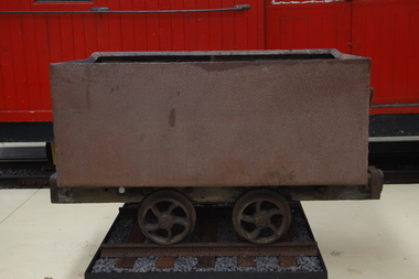 Puffing Billy Railway
Wonthaggi Coal Skip, Early 20th century
One of two types of four wheel skips widely used on the Wonthaggi Coal Fields for transportation from the underground workings to the surface screening and loading areas. Haulage underground was accomplished by the use of pit ponies, whilst an endless rope system was used to bring the skips to the surface areas. Much of the coal for the colony of Victoria was sourced from Newcastle and the Hunter Region in New South Wales, along with local supplies from private and co-operative coal mines at Outtrim, Jumbunna and Korumburra in Gippsland. After the 1909–1910 strike by coal miners in the Hunter Valley, the Victorian state government were determined to ensure stability in local supplies of coal. The State Coal Mine and the town of Wonthaggi came into being in 1910 to supply coal for the Victorian Railways. It was one of the largest and most dangerous collieries in Australia. At its peak in 1926 the mine produced 2,435 long tons (2,474 t) per day, with the Victorian Railways buying 90% of production. In 1928, Wonthaggi coal accounted for around 60% of Victorian Railways coal consumption.Historic - Industrial - Victorian Railways - Narrow Gauge Railway rolling stock - Wonthaggi Coal Fields, Victoria, AustraliaRectangular steel bin with wood frame and steel wheelspuffing billy, coal skip, wonthaggi, wonthaggi coal fields, 2'0" gauge, brown coal -
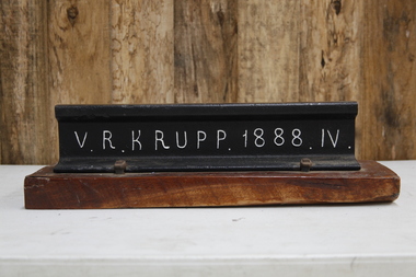 Puffing Billy Railway
V. R. Krupp 1888. IV. Rail, 1888
60lbs rail that was used throughout the Victorian rail network. In 1887 Gibbs, Bright and Co. had a contract with Victorian Railways for railway and canal construction and supply of Krupp Rails. Gibbs, Bright and Co were merchant bankers and shipping agents and merchants who where also Directors of the GWR ( Great Western Railway ) and the Ship The "Great Britain" in England Gibbs, Bright and Company had principally been involved in shipping and trading, mainly in the West Indies, but following the discovery of gold in Victoria they established an office in Melbourne and soon became one of the leading shipping agents and merchants in the Colony. They expanded into passenger shipping and soon established offices in Brisbane, Sydney, Newcastle, Adelaide and Perth as well as launching passenger services between England, Mauritius and New Zealand. Gibbs, Bright also held a number of financial agencies from British mortgage, finance and investment companies as well as representing several British insurance companies in Australia. In addition they conducted a growing import business as well as an export business that included livestock, dairy produce, wool and flour. Also the company played a substantial part in the development of Australia's mineral resources, starting with lead in 1895, and later venturing into tin, gold, copper, cement and super phosphates. In Australia, after WWI, many of the larger companies were managing their own import and export so Gibbs, Bright and Company tended to focus its Agency business on smaller companies while expanding their interest into other markets such as timber, wire netting, zinc, stevedoring, road transport, marine salvage, gold mining as well as mechanical, structural, electrical and marine engineering. The Company's shipping interests continued to grow as well and still formed a major part of its business. In 1948 the parent company in England took the major step from tradition when they changed the business from a partnership into a private limited company. The name was the same, Antony Gibbs and Sons Limited, and in practice the effect of the change was very little. Some of the firm's branches and departments had already become limited companies and the formation of a parent company simplified the structure. The Australian operation was in time changed to Gibbs Bright & Co Pty Ltd in 1963. In 1848 Alfred Krupp becomes the sole proprietor of the company which from 1850 experiences its first major growth surge. In 1849 his equally talented brother Hermann (1814 - 1879) takes over the hardware factory Metallwarenfabrik in Berndorf near Vienna, which Krupp had established together with Alexander Schöller six years earlier. The factory manufactures cutlery in a rolling process developed by the brothers. Krupp's main products are machinery and machine components made of high-quality cast steel, especially equipment for the railroads, most notably the seamless wheel tire, and from 1859 to an increased extent artillery. To secure raw materials and feedstock for his production, Krupp acquires ore deposits, coal mines and iron works. On Alfred Krupp's death in 1887 the company employs 20,200 people. His great business success is based on the quality of the products, systematic measures to secure sales, the use of new cost-effective steel-making techniques, good organization within the company, and the cultivation of a loyal and highly qualified workforce among other things through an extensive company welfare system. From 1878 August Thyssen starts to get involved in processing the products manufactured by Thyssen & Co., including the fabrication of pipes for gas lines. In 1882 he starts rolling sheet at Styrum, for which two years later he sets up a galvanizing shop. The foundation stone for Maschinenfabrik Thyssen & Co. is laid in 1883 with the purchase of a neighboring mechanical engineering company. In 1891 August Thyssen takes the first step toward creating a vertical company at the Gewerkschaft Deutscher Kaiser coal mine in [Duisburg-]Hamborn, which he expands to an integrated iron and steelmaking plant on the River Rhine. Just before the First World War he starts to expand his group internationally (Netherlands, UK, France, Russia, Mediterranean region, Argentina). info from The company thyssenkrupp - History https://www.thyssenkrupp.com/en/company/history/the-founding-families/alfred-krupp.htmlHistoric - Victorian Railways - Track Rail - made by Krupp in 1888Section of VR Krupp 1888 Rail mounted on a piece of varnished wood. Rail made of ironpuffing billy, krupp, rail, victorian railways -
 Robin Boyd Foundation
Document - Script, Robin Boyd, The Flying Dogtor. Episode 12 Caught!, 1963
There was an enormous crash and Crafty thought he had finally squashed the Dogtor but he was not harmed when the great stone fell, using his stethoscope to open the door. Crafty was hiding behind a shed in the yard waiting for the dust to settle. The Dogtor used his teeth to catch Crafty by the end of his tail but Crafty twisted and escaped through an opening in the back fence. He slipped into an old mine shaft and planned his next trap for the Dogtor.The Flying Dogtor" series was broadcast on Australian Television Network (later becoming the Seven Network) between February and April 1964 (see item D254 for schedule).Typewritten, carbon copy, foolscap, 3 pagesthe flying dogtor, robin boyd, crawford productions, manuscript -
 Robin Boyd Foundation
Document - Script, Robin Boyd, The Flying Dogtor. Episode 18 The Visitors, 1963
The mysterious spots were caused by mosquito bites, due to the stagnant water from the flood. They had run out of medicines, bandages, everything, with no money to buy more. The Dogtor discovered a gold nugget in his bag from the mines and told nurse Sister Spaniel to take it to the bank to change it for money. Life then returned to normal at Hilltop Hospital. Then one day, a big loud silver helicopter appeared in the sky with a notice: WOOMERA RANGE. V.I.P. TOP SECRET. SPACE SURVEY. ROCKET DIVISION.The Flying Dogtor" series was broadcast on Australian Television Network (later becoming the Seven Network) between February and April 1964 (see item D254 for schedule).Typewritten, carbon copy, foolscap, 2 pagesPage 1: handwritten 'CUT' on left hand side.the flying dogtor, robin boyd, crawford productions, manuscript -
 Stawell Historical Society Inc
Photograph, "Magdala-Cum-Moonlight" Mine at the 1100 ft level on visible gold looking South 1895
... south Underground Magdala-Cum-Moonlight Mine 1895. The mine... south Underground Magdala-Cum-Moonlight Mine 1895. The mine ...Face in Stopes at 1.100ft level on visible gold looking south Underground Magdala-Cum-Moonlight Mine 1895. The mine ceased production after World War 1.stawell mining -
 Rutherglen Historical Society
Photograph - Image, 1914-1920 (Approximate)
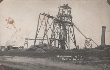
Shows one of Rutherglen's largest gold mines taken at the time when they were fully productive. It ceased production, machinery, chimneys & gravel heaps have disappeared.Black & white photograph, unframed but pasted to pages of an album. Garibaldi Mine, Rutherglen"Garabaldi Mine - Rutherglen" -
 Rutherglen Historical Society
Photograph - Image, 1914-1920 (Approximate)
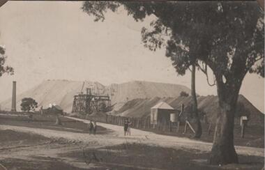
Shows one of Rutherglen's largest gold mines taken at the time when they were fully productive. It ceased production, machinery, chimneys & gravel heaps have disappeared.Black & white photograph, unframed but pasted to pages of an album. Great Southern"Great Southern" -
 Bendigo Historical Society Inc.
Book - BENDIGO: VICTORIA'S GOLDEN CITY
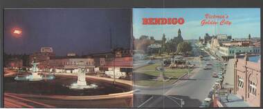
Coloured booklet of various scenes and buildings in and around Bendigo, titled Bendigo Victoria's Golden City. The front cover has a scene of Charing Cross looking towards Pall Mall. Inside the front cover is a very brief history and some Historical Buildings are mentioned. They are: Fortuna, Shamrock Hotel, Gold Mines Hotel, City Hall, Post Office, Law Courts, the Home for the Aged, Sacred Heart Cathedral, St. Paul's, Specimen Cottage, Log Lock-up and the Chinese Joss House. The coloured pictures inside are: The Central Deborah Gold Mine, Fortuna, Miner's Cottage, The Gold Mines Hotel, Victoria Hill, Bendigo Law Courts, Eaglehawk Log Lock-up, Look-out Tower Rosalind Park, Alexandra Fountain - Charing Cross, Conservatory Gardens with Law Courts in background, Inside the Conservatory, Bendigo Home & Hospital for the Aged - Victoria's 'White House', Sacred Heart Cathedral, Chinese Joss House, Chinese Joss House - Interior of the Main Temple, Bendigo Pottery - Potter at work, Bendigo Municipal Offices, Bendigo Institute of Technology at Flora Hill, Mt. Alvernia Hospital, Cobb & Co Coach, R Class Locomotive, Bendigo Tramcar, Lake Weeroona and Lake Eppalock Pumping Station. Some more attractions are mentioned inside the back cover. On the back cover is the Cenotaph - the only scale replica of the Whitehall Cenotaph - and Alexandra Fountain by night.Nucolorvue Productions Pty Ltdbendigo, tourism, photographs of bendigo icons, bendigo - victoria's golden city, fortuna, shamrock hotel, gold mines hotel, city hall, post office, law courts, home for the aged, victoria's 'white house', sacred heart cathedral, st paul's, specimen cottage, log lock-up, chinese joss house, charing cross, cenotaph, alexandra fountain, centra deborah gold mine, army cartographic unit, miner's cottage, harvey town, victoria hill, look-out tower rosalind park, conservatory gardens, conservatory, bendigo pottery, bendigo municipal offices, bendigo institute of technology, mt alvernia hospital, cobb & co coach, r class locomotive, bendigo railway station, bendigo tramcar, lake weeroona, lake eppalock pumping station, art gallery, historical museum eaglehawk, melville's caves, whitehall cenotaph, nucolorvue productins pty ltd, national library of australia -
 Bendigo Historical Society Inc.
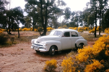
Slide - Peter Ellis Collection, Portrait, Cars and the Whipstick, c1970-1972
... When the numerous gold mines declined in production... the numerous gold mines declined in production, the eucalyptus oil ...When the numerous gold mines declined in production, the eucalyptus oil industry became an important source of work. The first eucalyptus oil producer in Bendigo was a chemist called Richard Sandner who operated a plant and refinery in Bridge Street from 1876. By 1900, many other distillers operated on the northern edge of Bendigo and in the Whipstick. In 1926, the Forest Commision established a eucalyptus distillery at Gunyah in Wellsford State Forest. See the Wellsford Forest Note for more information. Today, there are just two eucalypt distilleries operating in Bendigo. Most of the world’s eucalyptus oil is now produced overseas. Peter Ellis Collection: eight slides of his Holden FJ and a friend's car in the Whipstick Forest. Peter Ellis was a chemistry lecturer at the Bendigo Institute of Technolgyhistory, bendigo, peter ellis collection, bendigo institute of technology, b.i.t., whipstick bendigo, bendigo state forests, eucalyptus oil