Showing 1071 items
matching saxon
-
 Ballarat Heritage Services
Photograph - Colour, Stairs, Old Sarum, England, English Heritage Site, 2016, 01 November 2016
William the Conqueror inherited Old Sarum from the last Saxon king of England. It was an ideal site for a royal castle. It was here in 1070 that William paid off his army after a long and bitter campaign in northern England. It was here in 1086 that he called together all the major landholders in England so they could swear allegiance to him. It was a crucial moment. The Domesday Book was being written, a threatened Viking invasion had only just been averted and William's eldest son was in armed rebellion. Old Sarum was an important place where this Norman king of England held power. In 1794 the Ordnance Survey set out to check the accuracy of the first mapping of Southern England, which had begun ten years earlier. From a point just below Old Sarum Lieutenant William Mudge laid out a base-line 36,574 feet (11,253 metres) long. From each end of the line the positions of distant places were plotted using a huge theodolite made in 1791 by Jesse Ramsden. The accuracy of the process, which was repeated all over England, depended on Jesse Ramsden's craftsmanship and on William Mudge's surveying skill in setting out this first base-line from Old Sarum. The nearer end of Mudge's line is marked by an inscribed stone beside the modern A345 at Old Sarum. ordnance survey, william mudge, jesse ramsden, william the conqueror, old sarum, saxon, 1086, england -
 Ballarat Heritage Services
Photograph - Colour, Public toilets hidden in earth mound, Old Sarum, England, English Heritage Site, 2016, 01 November 2016
William the Conqueror inherited Old Sarum from the last Saxon king of England. It was an ideal site for a royal castle. It was here in 1070 that William paid off his army after a long and bitter campaign in northern England. It was here in 1086 that he called together all the major landholders in England so they could swear allegiance to him. It was a crucial moment. The Domesday Book was being written, a threatened Viking invasion had only just been averted and William's eldest son was in armed rebellion. Old Sarum was an important place where this Norman king of England held power. In 1794 the Ordnance Survey set out to check the accuracy of the first mapping of Southern England, which had begun ten years earlier. From a point just below Old Sarum Lieutenant William Mudge laid out a base-line 36,574 feet (11,253 metres) long. From each end of the line the positions of distant places were plotted using a huge theodolite made in 1791 by Jesse Ramsden. The accuracy of the process, which was repeated all over England, depended on Jesse Ramsden's craftsmanship and on William Mudge's surveying skill in setting out this first base-line from Old Sarum. The nearer end of Mudge's line is marked by an inscribed stone beside the modern A345 at Old Sarum. ordnance survey, william mudge, jesse ramsden, william the conqueror, old sarum, saxon, 1086, england -
 Ballarat Heritage Services
Photograph - Colour, Entrance to Public toilets hidden in earth mound, Old Sarum, England, English Heritage Site, 2016, 01 November 2016
William the Conqueror inherited Old Sarum from the last Saxon king of England. It was an ideal site for a royal castle. It was here in 1070 that William paid off his army after a long and bitter campaign in northern England. It was here in 1086 that he called together all the major landholders in England so they could swear allegiance to him. It was a crucial moment. The Domesday Book was being written, a threatened Viking invasion had only just been averted and William's eldest son was in armed rebellion. Old Sarum was an important place where this Norman king of England held power. In 1794 the Ordnance Survey set out to check the accuracy of the first mapping of Southern England, which had begun ten years earlier. From a point just below Old Sarum Lieutenant William Mudge laid out a base-line 36,574 feet (11,253 metres) long. From each end of the line the positions of distant places were plotted using a huge theodolite made in 1791 by Jesse Ramsden. The accuracy of the process, which was repeated all over England, depended on Jesse Ramsden's craftsmanship and on William Mudge's surveying skill in setting out this first base-line from Old Sarum. The nearer end of Mudge's line is marked by an inscribed stone beside the modern A345 at Old Sarum. ordnance survey, william mudge, jesse ramsden, william the conqueror, old sarum, saxon, 1086, england -
 Ballarat Heritage Services
Photograph - Colour, Masons' Marks, Old Sarum, England, English Heritage Site, 2016, 01 November 2016
William the Conqueror inherited Old Sarum from the last Saxon king of England. It was an ideal site for a royal castle. It was here in 1070 that William paid off his army after a long and bitter campaign in northern England. It was here in 1086 that he called together all the major landholders in England so they could swear allegiance to him. It was a crucial moment. The Domesday Book was being written, a threatened Viking invasion had only just been averted and William's eldest son was in armed rebellion. Old Sarum was an important place where this Norman king of England held power. In 1794 the Ordnance Survey set out to check the accuracy of the first mapping of Southern England, which had begun ten years earlier. From a point just below Old Sarum Lieutenant William Mudge laid out a base-line 36,574 feet (11,253 metres) long. From each end of the line the positions of distant places were plotted using a huge theodolite made in 1791 by Jesse Ramsden. The accuracy of the process, which was repeated all over England, depended on Jesse Ramsden's craftsmanship and on William Mudge's surveying skill in setting out this first base-line from Old Sarum. The nearer end of Mudge's line is marked by an inscribed stone beside the modern A345 at Old Sarum. ordnance survey, william mudge, jesse ramsden, william the conqueror, old sarum, saxon, 1086, england -
 Ballarat Heritage Services
Photograph - Colour, Masons' Marks, Old Sarum, England, English Heritage Site, 01 November 2016
William the Conqueror inherited Old Sarum from the last Saxon king of England. It was an ideal site for a royal castle. It was here in 1070 that William paid off his army after a long and bitter campaign in northern England. It was here in 1086 that he called together all the major landholders in England so they could swear allegiance to him. It was a crucial moment. The Domesday Book was being written, a threatened Viking invasion had only just been averted and William's eldest son was in armed rebellion. Old Sarum was an important place where this Norman king of England held power. In 1794 the Ordnance Survey set out to check the accuracy of the first mapping of Southern England, which had begun ten years earlier. From a point just below Old Sarum Lieutenant William Mudge laid out a base-line 36,574 feet (11,253 metres) long. From each end of the line the positions of distant places were plotted using a huge theodolite made in 1791 by Jesse Ramsden. The accuracy of the process, which was repeated all over England, depended on Jesse Ramsden's craftsmanship and on William Mudge's surveying skill in setting out this first base-line from Old Sarum. The nearer end of Mudge's line is marked by an inscribed stone beside the modern A345 at Old Sarum. ordnance survey, william mudge, jesse ramsden, william the conqueror, old sarum, saxon, 1086, england -
 Ballarat Heritage Services
Photograph - Colour, Masons' Marks, Old Sarum, England, English Heritage Site, 2016, 01 November 2016
William the Conqueror inherited Old Sarum from the last Saxon king of England. It was an ideal site for a royal castle. It was here in 1070 that William paid off his army after a long and bitter campaign in northern England. It was here in 1086 that he called together all the major landholders in England so they could swear allegiance to him. It was a crucial moment. The Domesday Book was being written, a threatened Viking invasion had only just been averted and William's eldest son was in armed rebellion. Old Sarum was an important place where this Norman king of England held power. In 1794 the Ordnance Survey set out to check the accuracy of the first mapping of Southern England, which had begun ten years earlier. From a point just below Old Sarum Lieutenant William Mudge laid out a base-line 36,574 feet (11,253 metres) long. From each end of the line the positions of distant places were plotted using a huge theodolite made in 1791 by Jesse Ramsden. The accuracy of the process, which was repeated all over England, depended on Jesse Ramsden's craftsmanship and on William Mudge's surveying skill in setting out this first base-line from Old Sarum. The nearer end of Mudge's line is marked by an inscribed stone beside the modern A345 at Old Sarum. ordnance survey, william mudge, jesse ramsden, william the conqueror, old sarum, saxon, 1086, england -
 Ballarat Heritage Services
Photograph - Colour, Masons' Marks, Old Sarum, England, English Heritage Site, 2016, 01 November 2016
William the Conqueror inherited Old Sarum from the last Saxon king of England. It was an ideal site for a royal castle. It was here in 1070 that William paid off his army after a long and bitter campaign in northern England. It was here in 1086 that he called together all the major landholders in England so they could swear allegiance to him. It was a crucial moment. The Domesday Book was being written, a threatened Viking invasion had only just been averted and William's eldest son was in armed rebellion. Old Sarum was an important place where this Norman king of England held power. In 1794 the Ordnance Survey set out to check the accuracy of the first mapping of Southern England, which had begun ten years earlier. From a point just below Old Sarum Lieutenant William Mudge laid out a base-line 36,574 feet (11,253 metres) long. From each end of the line the positions of distant places were plotted using a huge theodolite made in 1791 by Jesse Ramsden. The accuracy of the process, which was repeated all over England, depended on Jesse Ramsden's craftsmanship and on William Mudge's surveying skill in setting out this first base-line from Old Sarum. The nearer end of Mudge's line is marked by an inscribed stone beside the modern A345 at Old Sarum. ordnance survey, william mudge, jesse ramsden, william the conqueror, old sarum, saxon, 1086, england -
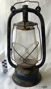 Flagstaff Hill Maritime Museum and Village
Functional object - Hurricane Lantern, Nier Feuerhand, Between 1915-1920
The Feuerhand lantern works were established in Beierfeld in the Saxon Ore Mountains. Called Erzgebirge in German or Krušné hory in Czech, is a mountain range in the south of Saxony in Germany known for its craftwork. Lantern production began in the area by Hermann Nier who ran a plumber's workshop around the 1870s and made lanterns, amongst other things. In the town of Beierfeld, also well-known for its metalworking were the brothers Hermann and Ernst Nier who founded a modern production centre for hurricane lanterns manufacture in 1893. Five years after the foundation, the company Frankonia (Albert Frank metalware) bought up the production site and the brothers Nier became production managers. Owing to differences with Frankonia, Hermann Nier finally started its hurricane lantern factory "Hermann Nier Feuerhandwerk" in 1902. In the same year, he applied for a patent for the manufacturing of lanterns using the stamping and folding techniques with tinning by hot-dipping and without hand-soldering. In 1914 the trademark "Feuerhand" was registered for all products as a utility model of the German Reich in German: "Deutsches Reichs-Gebrauchsmuster" (DRGM) and in 1920 the round Feuerhand emblem was added to the brand. Finally, in 1926 the patents, as well as the trademark "Firehand", were also registered in the USA. The manufacture of the well-known small hurricane lanterns the “Baby Series” complete with fireproof borosilicate glass from the Firma Schott firm from Jena started in 1933. Between 1918 and 1938 Nier Feuerhand became the biggest producer of hurricane lanterns in the world. Production continued until 1990.A significant item that demonstrates from its fabrication a manufacturing process that was far in advance of its time and that influenced the production of lanterns from many other manufactures around the world. These types of lanterns made by Feuerhand around the early 20th century are now sought after by collectors.Monarch style Lantern painted black. Made in Germany has Freuerhand, manufactures logo on filler cap and top of lamp centre postflagstaff hill, warrnambool, flagstaff-hill-maritime-museum, maritime-museum, shipwreck-coast, flagstaff-hill-maritime-village, hurricane lantern, kerosene lamp, feuerhand lantern works, albert frank metalware, hermann and ernst nier -
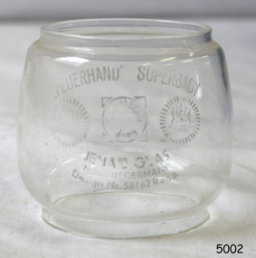 Flagstaff Hill Maritime Museum and Village
Functional object - Lantern Glass, Nier Feuerhand, 1933
The Feuerhand lantern works were established in Beierfeld in the Saxon Ore Mountains. Called Erzgebirge in German or Krušné hory in Czech, is a mountain range in the south of Saxony in Germany known for its craftwork. Lantern production began in the area by Hermann Nier who ran a plumber's workshop around the 1870s and made lanterns, amongst other things. In the town of Beierfeld, also well-known for its metalworking were the brothers Hermann and Ernst Nier who founded a modern production centre for hurricane lanterns manufacture in 1893. Five years after the foundation, the company Frankonia (Albert Frank metalware) bought up the production site and the brothers Nier became production managers. Owing to differences with Frankonia, Hermann Nier finally started its hurricane lantern factory "Hermann Nier Feuerhandwerk" in 1902. In the same year, he applied for a patent for the manufacturing of lanterns using the stamping and folding techniques with tinning by hot-dipping and without hand-soldering. In 1914 the trademark "Feuerhand" was registered for all products as a utility model of the German Reich in German: "Deutsches Reichs-Gebrauchsmuster" (DRGM) and in 1920 the round Feuerhand emblem was added to the brand. Finally, in 1926 the patents, as well as the trademark "Firehand", were also registered in the USA. The manufacture of the well-known small hurricane lanterns the “Baby Series” complete with fireproof borosilicate glass from the Firma Schott firm from Jena started in 1933. Between 1918 and 1938 Nier Feuerhand became the biggest producer of hurricane lanterns in the world. Production continued until 1990.A significant item that demonstrates from its fabrication a manufacturing process that was far in advance of its time and that influenced the production of lanterns from many other manufactures around the world. These types of lanterns made by Feuerhand around the early 20th century are now sought after by collectors.Small round lantern replacement glass called "Feuerhand" Superbaby Model. Design No 58162.flagstaff hill, warrnambool, shipwrecked-coast, flagstaff-hill, flagstaff-hill-maritime-museum, maritime-museum, shipwreck-coast, flagstaff-hill-maritime-village, hurricane lamp glass replacement, glass, hurricane lamp, feuerhand lantern, jena glass works -
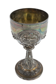 National Wool Museum
Trophy
This trophy was awarded to William Kermode of Mona Vale for the best pair of Merino ewes exhibited at the Southern Tasmanian Agricultural and Pastoral Society in October, 1879. William Kermode formed the Mona Vale flock in 1829 with VDL C. Saxons. In the early 1870s under Kermode, Ercildoun rams were tried, as was a St Johnstone ram. It is well documented that the famous Steiger-blood ram, Sir Robert (out of a Mona Vale ewe), had considerable impact on a number of Tasmania's influential studs. At its height in the late nineteenth century, Mona Vale was regarded as "... one of Tasmania's leading and parent studs, producing robust fine-wool sheep with quality, long-stapled and dense wool." (Massy 1990: p.406). The first agricultural society in Australia was formed in Hobart on 1 Jan. 1822. The trophy was retailed by Walsh Brothers, Melbourne in c.1875. The cup has no makers marks, but has been attributed by Christie's to Edward Fischer, a local Geelong silversmith. This attribution is based upon stylistic criteria. However, Ms Veronica Filmer of the Geelong Art Gallery (curator of "Geelong's Colonial Silversmiths", Geelong Art Gallery, 1988), has suggested that the lack of stamps is unusual (most of Fishcher's work was stamped) and also that it is somewhat heavy for Fischer's work. The trophy originated from the collection of Edward Clark, an antique dealer. Prior ownership of the trophy is uncertain, but it is believed that Clark purchased it in the mid 1990s from descendants of the original prize recipients.Trophy, sterling silver. Circular, stepped base and tapering stem decorated with cartouches of leaves on a matt background. The bowl of the trophy has an applied belt cartouche with an inscription. Within the belt cartouche is an engraved and embossed panel of two sheep with a cottage in the background. There are ribbon tied floral swags on either side of the cartouche, and a presentation inscription with a beaded border on the reverse of the bowl.SOUTHERN TASMANIAN AGRICULTURAL & PASTORAL SOCIETY Presented / to / Joseph Clarke Esq / and awarded to / W.A. Kermode Esq / of Mona Vale / for Best Pair Merino Ewes, / October 1879southern tasmanian agricultural and pastoral society, logo merino: sheep in australian art and design - exhibition (29/07/2000 - 04/02/2001), fischer, mr edward - silversmiths and jewellers kermode, mr william - mona vale stud clarke, mr joseph, mona vale stud, tasmania -
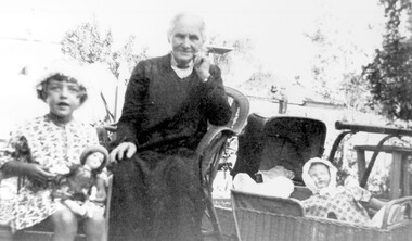 Surrey Hills Historical Society Collection
Photograph, Annie Barton and Jocelyn Cerini, 1928, c1928
The photo was taken in 1928 and the young child is definately Jocelyn Francesca Cerini, elder daughter of Natale Cerini and his wife Ethel (MS: Swan). The Cerini family lived at 215 Union Road. Most likely that the photo was taken in the back garden of 215 Union Road which backs onto 11 and 13 Barton Street. Thus the houses in the background are the two houses occupied by Barton family members - No 11 and 13 Barton Street, Surrey Hills. The photo card index compiled by Jocelyn Hall (nee Cerini) identifies the elderly lady as Miss Annie Barton, sister of Rev John Barton, second minister of Wyclif Congregational Church. She was a nurse. However the age of Jocelyn (born 1922) makes it more likely that this is Mrs Annie Eliza Barton (nee Duncan), wife of the Rev John Barton and mother of James Duncan Barton, John Saxon Barton, Ida Grace Barton, Albert Edward Barton, Annie Barton and Harold Arthur Barton. Annie Eliza (Duncan) Barton was born in 1845 and died on 16 Jan 1933, which is consistent with the age of the lady pictured. By the time this photo was taken her husband, the Rev John Barton (1844-1919) had died. He was minister of the Wyclif Church in 1896 and continued in that role until 1907. After a further appointment John Barton retired and continued to worship at Wyclif, residing at 13 Barton Street. On Federation in 1901 the street name changed - it was originally Kent Street. John Barton was born in 1845 in Ainsdale, Lancashire, son of James Barton and Ann Rimmer and grew up in Formby - the name later given to No 13 Barton Street. His family appear to have remained in the UK. He married Ann Eliza Duncan in 1872 in Queensland. Of the 2 daughters who were nurses: Ida Grace Barton (b 1877) did not marry. She trained at the Homeopathic Hospital (later Prince Henry's Hospital), graduating in 1909. Annie Barton (b 1883, Geelong) trained at the Melbourne Hospital. She was Matron AANS during WW1 in charge of the Base Hospital (Military) in St Kilda Road. She married Dr John Hodgson Nattrass. She died in 1965 at Caulfield. John and Ann Eliza Barton are buried in Box Hill Cemetery - C0044.A black & white photo of an elderly lady seated in a cane chair in an outdoor setting. To one side is a young girl also seated in a chair and holding a doll; to the other side is a doll's pram containing another doll. The background is indistinct but appear to be houses.clothing and dress, 1928, miss jocelyn francesca cerini, mrs jocelyn hall, annie eliza duncan, annie eliza barton, box hill cemetery, rev john barton, jocelyn cerini, dolls, 215 union road -
 Bendigo Historical Society Inc.
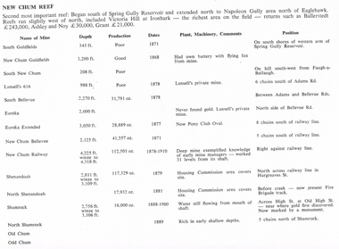
Document - LONG GULLY HISTORY GROUP COLLECTION: NEW CHUM REEF
Six pages titled New Chum Reef. No number on the first page, the others are 109 to 113. Mentions location of the reef and some of the rich mines. The mines are mentioned in a table with the Name of Mine; Depth; Production; Dates; Plant, Machinery, Comments and Position. Ballerstedt, Ashley and Noy, and Grant were three of the successful miners. Mines mentioned are: South Goldfields, New Chum Goldfields, South New Chum, Lansell's 616, South Bellevue, Eureka, Eureka Extended, New Chum Bellevue, New chum Railway, Shenandoah, North Shenandoah, Shamrock, Old Chum, Little Chum, Young Chum, Craven, Garibaldi, Ellesmere, South Old Chum, New Chum Consolidated, North Ellesmere, New Chum United, Lansell's 222, Lansell's Fortuna, Lazarus, West End, Pioneer, Old Chum, New Chum Victoria, North Old Chum, Lansell's Big 180, Sterry, Victoria Quartz, South Adventure, Great Central Victoria, Ballerstedt No 3, Adventure, Humbold, British and American, Midway, Victoria Consuls, Victoria absorbed by Ironbark, Hercules and Energetic, Victoria Pilot, North Hercules and Energetic, Great Extended Hercules, Pearl, Southern Victoria, Great Extended Victoria, Young Victoria, New Catherine Victoria, Weatern Victoria, New Victoria St Mungo, Surprise, Mystery, Duke of Edinburgh, New St Mungo, Duchess Tribute, South Devonshire, Duchess of Edinburgh, West United Devonshire, Albert, United Devonshire, Saxon and Celt, Hopewell, Prince of Wales, Phoenix, Unicorn, South St Mungo, Princess Alice, Lady Barkly, North Devonshire, Ranzeau, St Mungo, Dublin and Cornwall, Sadowa, Eastwood, Ellenborough, Belmont and Saxeby, Snobs Hill, York and Durham, La bElle, Old Williams United, Arcadia, Williams United, South Catherine, Central Catherine, Catherine United, Murchison, New Franklin, Catherine Extended, Pony Club Oval, Housing Commission, Mt Alvernia Hospital, Fortuna, Lunt, Army Survey Unit, Wybrandt, John Brown Factory, Canterbury, Hercules and Energetic and the North Red White and Blue.bendigo, history, long gully history group, the long gully history group - new chum reef, ballerstedt, ashley and noy, grant, south goldfields, new chum goldfields, south new chum, lansell's 616, south bellevue, eureka, eureka extended, new chum bellevue, new chum railway, shenandoah, north shenandoah, shamrock, old chum, little chum, young chum, craven, garibaldi, ellesmere, south old chum, new chum consolidated, north ellesmere, new chum united, lansell's 222, lansell's fortuna, lazarus, west end, pioneer, old chum, new chum victoria, north old chum, lansell's big 180, sterry, victoria quartz, south adventure, great central victoria, ballerstedt no 3, adventure, humbold, british and american, midway, victoria consuls, victoria absorbed by ironbark, hercules and energetic, victoria pilot, north hercules and energetic, great extended hercules, pearl, southern victoria, great extended victoria, young victoria, new catherine victoria, weatern victoria, new victoria st mungo, surprise, mystery, duke of edinburgh, new st mungo, duchess tribute, south devonshire, duchess of edinburgh, west united devonshire, albert, united devonshire, saxon and celt, hopewell, prince of wales, phoenix, unicorn, south st mungo, princess alice, lady barkly, north devonshire, ranzeau, st mungo, dublin and cornwall, sadowa, eastwood, ellenborough, belmont and saxeby, snobs hill, york and durham, la belle, old williams united, arcadia, williams united, south catherine, central catherine, catherine united, murchison, new franklin, catherine extended, pony club oval, housing commission, mt alvernia hospital, fortuna, lunt, army survey unit, wybrandt, john brown factory, canterbury, hercules and energetic, north red white and blue -
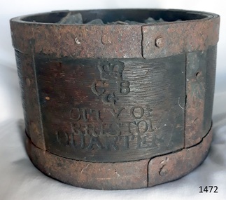 Flagstaff Hill Maritime Museum and Village
Functional object - Dry Measurement Container, Late 18th to early 19th century (before the standardised measurement was introduced in England in 1824)
The peck has been in use since the early 14th century when it was introduced as a measure for flour. The term referred to varying quantities until the modern units of measurement were defined in the 19th century. Cities in England used to have official standard weights and measures for that city or area. These containers were marked with the city's name and emblem, merchant’s weights and measures would then be checked against this to make sure they weren't trying to cheat their customers. The item in the collection is a standard measure approved by Bristol City and used by that City’s grocers to measure dry goods such as peas, beans, sugar, flour, meal etc., and its metal banding ensures that the measure cannot be reduced in size to cheat customers. Additional Information: The British Imperial System evolved from the thousands of Roman, Celtic, Anglo-Saxon, and customary local units employed in the middle Ages. Traditional names such as pound, foot, and gallon were widely used, but the values so designated varied with time, place, trade, product specifications, and dozens of other requirements. Early royal standards were established to enforce uniformity took the name Winchester, after the ancient tenth century capital of Britain. King Henry VII reaffirmed the customary Winchester standards for capacity and length and distributed royal standards throughout the realm. This process was repeated about a century later in the reign of Queen Elizabeth I. In the 16th century, the rod (5.5 yards, or 16.5 feet) was defined (once again as a learning device and not as a standard) defined by the length of the left feet of 16 men lined up heel to toe as they emerged from the church. By the 17th century usage and legal statute had established the acre, rod, and furlong at their present values together with other historic units such as the peck. Establishment of the System: The Weights and Measures Act of 1824 and the Act of 1878 established the British Imperial System based on precise definitions of selected existing units. The 1824 act sanctioned a single imperial gallon to replace the wine, ale, and corn (wheat) gallons that were in general use. The new gallon was defined as equal in volume to 10 pounds avoirdupois of distilled water weighed at 62°F with the barometer at 30 inches, or 277.274 cubic inches (later corrected to 277.421 cubic inches). The two new basic standard units were the imperial standard yard and the troy pound, which was later restricted to weighing drugs, precious metals, and jewels. In 1963 an act of parliament abolished archaic measures as the rod and chaldron and a metric system was adopted. An early example of a dry measuring container giving a snapshot of how imperial weights and measures developed in England to evolve the British measurement system into the metric arrangement that most countries have adopted today including Australia. It has social significance as an item that was in everyday use by grocers and other merchants to measure dry goods in the late 18th to early 19th centuries and used specifically in the Bristol region of England as an officially recognised measurement.Wooden measurement container with iron banding and hand made rivets container is a Quarter Peck official measurement container. Inscriptions are impressed into the sides of the wooden body. The container has the official crown and emblem of the City of Bristol, indicating this item was the Bristol City standard quarter peck measurement.Impressed into the timber on the front, a crown emblem over "C B G / CITY OF BRISTOL / QUARTER", on one side "HALF" , another side "PECK". Handwritten in white chalk on the base is "1458"flagstaff hill, warrnambool, shipwrecked-coast, flagstaff-hill-maritime-museum, flagstaff-hill-maritime-village, weights and measures, quarter peck, measurement container, dry grocery measure, bristol city measurement standard, city of bristol, british weights and measures, 18th and 19th centure standard measures -
 Bendigo Historical Society Inc.
Document - NEW CHUM LINE OF REEF - NOTES ON SHAFT DETAILS ON THE NEW CHUM LINE OF REEF
Ten pages and one smaller page of notes showing depth of shaft, sill, size of shaft, relation to line of reef, depth bottom plat, depth to bottom of well, number of compartments, reference and remarks. Mines mentioned are: Young Chum, Old Chum (Old South), Shamrock, Shenandoah, New Chum Railway, Eureka Ext'd, South Belle Vue United, Lansell's 222, Denis Shaft, New Chum United, Ellesmere (North Shaft), New Chum Consolidated, Ellesmere No 1 or (South Shaft) also known as New Chum Coy, Garibaldi, Craven's, Lansell's Bit 180, North Old Chum, New Chum & Victoria, Old Chum, Lazarus New Chum Main, Lazarus New Chum (Old), Victoria Reef Gold (Ironbark), Victoria Consols, Adventure & Advance, Gt Central Victoria, Ballerstedt, Humbold, Victoria (Reef) Quartz, Pearl (later Hercules New Chum), Hercules Extended (Pearl (South) later, North Hercules, Hercules and Energetic, Hercules (Old),South Devonshire, Duchess Tribute, New St Mungo, Duke of Edinburgh, New Victoria Catherine (later Hercules Consols), Dixon's Tribute, Great Victoria Extended, Hopewell, Saxon & Celt Extended, St Mungo, Princess Alexander,West United Devonshire, United Devonshire, Duchess of Edinburgh, Sadowa, (Old) St Mungo, Lady Barkly, Princess Alice (South St Mungo) previously Gov. Barkly, Unicorn (Trib), Phoenix, Williams (New), Acadia Catherine, William United (Old Shaft), Snob's Hill Shaft, York & Durham, Belmont & Saxby, Ellenborough, Catherine Reef Extended, New Franklin, Murchison, Catherine Reef United Main Shaft, Catherine Reef United South Shaft. Small page has notes on the York and Durham: Reference - Matthew Mann - Mine Manager's Report 3/7/1893. This paragraph: Quote - 'Also measured main shaft from surface 1,430 and found it to be 1,416 feet and from Brace - 1,428 feet. Poppet legs 12 feet. Reference - Matthew Mann - Mine Manager's Report 15/7/1893 'Received cheque from La Belle Co. for 2 pound 13 shillings - which I payed into credit of Company'. Note: Report shows this to happen on several occasions. Note initialled AR.document, gold, new chum line of reef, new chum line of reef, notes on shaft details on the new chum line of reef, young chum, old chum (old south), shamrock, shenandoah, new chum railway, eureka ext'd, south belle vue united, lansell's 222, denis shaft, new chum united, ellesmere (north shaft), new chum consolidated, ellesmere no 1 or (south shaft) also known as new chum coy, garibaldi, craven's, lansell's bit 180, north old chum, new chum & victoria, old chum, lazarus new chum main, lazarus new chum (old), victoria reef gold (ironbark), victoria consols, adventure & advance, gt central victoria, ballerstedt, humbold, victoria (reef) quartz, pearl (later hercules new chum), hercules extended (pearl (south) later, north hercules, hercules and energetic, hercules (old), south devonshire, duchess tribute, new st mungo, duke of edinburgh, new victoria catherine (later hercules consols), dixon's tribute, great victoria extended, hopewell, saxon & celt extended, st mungo, princess alexander, west united devonshire, united devonshire, duchess of edinburgh, sadowa, (old) st mungo, lady barkly, princess alice (south st mungo) previously gov. barkly, unicorn (trib), phoenix, williams (new), acadia catherine, william united (old shaft), snob's hill shaft, york & durham, belmont & saxby, ellenborough, catherine reef extended, new franklin, murchison, catherine reef united main shaft, catherine reef united south shaft -
 Ballarat and District Irish Association
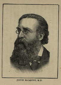
Image, Justin McCarthy M.P., 1864
McCarthy, JUSTIN, Irish politician, journalist, novelist, and historian, b. at Cork, November 22, 1830; d. at Folkestone, England, June 24, 1912. He was the son of Michael McCarthy, and was educated at a private school in his native city. At the age of eighteen he obtained a position on the literary staff of the "Cork Examiner". In 1853 he went to Liverpool as a journalist; in 1860 became Parliamentary reporter of the London "Morning Star", which he edited later (1864-68). From 1868 till 1871 he lectured with great success throughout the United States of America and was one of the assistant editors of the New York "Independent". On his return to England he contributed frequently to the "Nineteenth Century", the "Fortnightly Review", and the "Contemporary Review", and for many years was leader writer for the London "Daily News". From 1879 till 1896 he was a member of the British Parliament, representing the Irish constituencies of County Longford, Derry City, and North Longford. In November, 1880, he joined the Irish Land League, which won so many victories for the Catholic peasantry; two years later he became chairman of the National Land and Labor League of Great Britain. In 1886 he revisited the United States. From 1890 till 1896 he was chairman of the Irish Parliamentary party in succession to Parnell, having previously been vice-chairman for many years. His courtesy and moderation won him the respect of all parties in Parliament. Though participating so actively in the political life of Ireland, McCarthy took more interest in letters than in politics. His first novel, "The Waterdale Neighbors", appeared in 1867, and was followed by about twenty others, many of which are still popular. Of these the chief are: "Dear Lady Disdain" (1875); "A Fair Saxon" (1873); "Miss Misanthrope" (1877) and "The Dictator" (1893). Other publications were: "Con Amore", a volume of essays (1868), and biographies of Sir Robert Peel (1891), Leo XIII (1896), and Gladstone (1897). McCarthy's popularity as a writer depends rather on his historical writings, which are always lucid, forceful, and wonderfully free from party spirit. Of these works the most important are: "History of our own Times" (7 vols., London, 1879-1905), dealing with the events from the year 1830 to the death of Queen Victoria and supplemented by "Reminiscences of an Irishman" (1899); "A short History of our own Times" (1888); "The Epoch of Reform, 1830-1850" (London, 1874); "History of the Four Georges" (4 vols., 1884-1901), of which vols. 3 and 4 were written in collaboration with his son, Justin Huntly McCarthy well-known as a novelist and play-writer; "Ireland and her Story" (1903); "Modern England" (1899); "Rome in Ireland" (1904). Failing health and old age could not induce McCarthy to lay down his pen, and even as late as November, 1911, he published his "Irish Recollections", describing with his wonted charm the events of his earlier life. He was an ardent advocate of Catholic rights, and, though he had been indifferent for many years, in his old age he returned to the practices of his religion. A.A. MACERLEAN [http://oce.catholic.com/index.php?title=Justin_McCarthy, accessed 3/12/2013]Image of a bearded man wearing glasses. He is Justin McCarthy, M.P.ballarat irish, justin mccarthy, cork -
 Ballarat Heritage Services
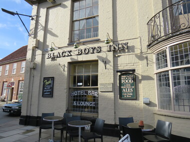
digital photographs, Inn, Aylesham, England, 2016
Black Boys Inn is in the market square of Aylesham, England. "Archaeological evidence shows that the site of the town has been occupied since prehistoric times. Aylsham is just over two miles (3 km) from a substantial Roman settlement at Brampton, linked to Venta Icenorum at Caistor St Edmund, south of Norwich, by a Roman road which can still be traced in places - that site was a bustling industrial centre with maritime links to the rest of the empire. Excavations in the 1970s provided evidence of several kilns, showing that this was an industrial centre, pottery and metal items being the main items manufactured. Aylsham is thought to have been founded around 500 AD by an Anglo Saxon thegn called Aegel, Aegel's Ham, meaning "Aegel's settlement". The town is mentioned in the Domesday Book of 1086 as Elesham and Ailesham, with a population of about 1,000. Until the 15th century, the linen and worsted industry was important here, as well as in North Walsham and Worstead and Aylsham webb or 'cloth of Aylsham' was supplied to the royal palaces of Edward II and III. John of Gaunt was lord of the manor from 1372 and Aylsham became the principal town of the Duchy of Lancaster. Although John of Gaunt probably never came to Aylsham, the townspeople enjoyed many privileges, including exemption from jury service outside the manor and from payment of certain taxes. The village sign depicts John of Gaunt. In 1519 Henry VIII granted a market on Saturdays and an annual fair to be held on 12 March, which was the eve of the feast of St Gregory the pope. Aylsham markets have always been an important feature of the town, and businesses developed to meet the needs of the town and the farming lands around it. Besides weekly markets there were cattle fairs twice a year and, in October, a hiring fair. The historic Black Boys Inn in the Market Place is one of Aylsham's oldest surviving buildings, and has been on the site since the 1650s, although the present frontage dates to between 1710 and 1720. There is a frieze of small black boys on the cornice and a good staircase and assembly room. The Black Boys was a stop for the post coach from Norwich to Cromer, had stabling for 40 horses, and employed three ostlers and four postboys. A thatched waterpump was built in 1911 at Carr's Corner in memory of John Soame by his uncle, a wealthy financier. An artesian well 170 feet (52 m) deep, its canopy is thatched in Norfolk reed. As with many of the other market towns in the county, the weaving of local cloth brought prosperity to the town in medieval times. Until the 15th century it was the manufacture of linen which was the more important, and Aylsham linens and Aylsham canvases were nationally known. From the 16th century linen manufacture declined and wool became more important, a situation that continued until the coming of the Industrial Revolution. Thereafter the principal trade of the town for the 19th century was grain and timber, together with the range of trades to be found in a town which supported local agriculture. Records show that Aylsham had markets and fairs, certainly from the 13th century. Such weekly and annual events were important for the trade that they brought. Annual horse fairs would bring many other traders to the town, and the weekly market would be the occasion for more local trade. The rights of the stallholders in the market place today date back to the rights established in medieval times." See wikipediaDigital photograph colouredinn, aylsham, england, black boys inn, market square -
 Ballarat Heritage Services
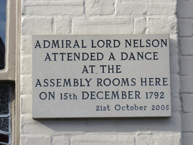
Photograph - Digital photograph, Lord Nelson Plaque, 2016
Black Boys Inn is in the market square of Aylsham, England. "Archaeological evidence shows that the site of the town has been occupied since prehistoric times. Aylsham is just over two miles (3 km) from a substantial Roman settlement at Brampton, linked to Venta Icenorum at Caistor St Edmund, south of Norwich, by a Roman road which can still be traced in places - that site was a bustling industrial centre with maritime links to the rest of the empire. Excavations in the 1970s provided evidence of several kilns, showing that this was an industrial centre, pottery and metal items being the main items manufactured. Aylsham is thought to have been founded around 500 AD by an Anglo Saxon thegn called Aegel, Aegel's Ham, meaning "Aegel's settlement". The town is mentioned in the Domesday Book of 1086 as Elesham and Ailesham, with a population of about 1,000. Until the 15th century, the linen and worsted industry was important here, as well as in North Walsham and Worstead and Aylsham webb or 'cloth of Aylsham' was supplied to the royal palaces of Edward II and III. John of Gaunt was lord of the manor from 1372 and Aylsham became the principal town of the Duchy of Lancaster. Although John of Gaunt probably never came to Aylsham, the townspeople enjoyed many privileges, including exemption from jury service outside the manor and from payment of certain taxes. The village sign depicts John of Gaunt. In 1519 Henry VIII granted a market on Saturdays and an annual fair to be held on 12 March, which was the eve of the feast of St Gregory the pope. Aylsham markets have always been an important feature of the town, and businesses developed to meet the needs of the town and the farming lands around it. Besides weekly markets there were cattle fairs twice a year and, in October, a hiring fair. The historic Black Boys Inn in the Market Place is one of Aylsham's oldest surviving buildings, and has been on the site since the 1650s, although the present frontage dates to between 1710 and 1720. There is a frieze of small black boys on the cornice and a good staircase and assembly room. The Black Boys was a stop for the post coach from Norwich to Cromer, had stabling for 40 horses, and employed three ostlers and four postboys. A thatched waterpump was built in 1911 at Carr's Corner in memory of John Soame by his uncle, a wealthy financier. An artesian well 170 feet (52 m) deep, its canopy is thatched in Norfolk reed. As with many of the other market towns in the county, the weaving of local cloth brought prosperity to the town in medieval times. Until the 15th century it was the manufacture of linen which was the more important, and Aylsham linens and Aylsham canvases were nationally known. From the 16th century linen manufacture declined and wool became more important, a situation that continued until the coming of the Industrial Revolution. Thereafter the principal trade of the town for the 19th century was grain and timber, together with the range of trades to be found in a town which supported local agriculture. Records show that Aylsham had markets and fairs, certainly from the 13th century. Such weekly and annual events were important for the trade that they brought. Annual horse fairs would bring many other traders to the town, and the weekly market would be the occasion for more local trade. The rights of the stallholders in the market place today date back to the rights established in medieval times." See wikipediaDigital photograph"Admiral Lord Nelson attended a dance at the Assembly rooms here on 15th December 1792 - 21st October 2005"aylsham, lord nelson, 1792, plaque -
 Ballarat Heritage Services
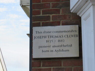
Photograph - Digital photograph, Dorothy Wickham, Plaque to Joseph Thomas Clover, ć2016
Lord Nelson plaque is in the town of Aylsham. "Archaeological evidence shows that the site of the town has been occupied since prehistoric times. Aylsham is just over two miles (3 km) from a substantial Roman settlement at Brampton, linked to Venta Icenorum at Caistor St Edmund, south of Norwich, by a Roman road which can still be traced in places - that site was a bustling industrial centre with maritime links to the rest of the empire. Excavations in the 1970s provided evidence of several kilns, showing that this was an industrial centre, pottery and metal items being the main items manufactured. Aylsham is thought to have been founded around 500 AD by an Anglo Saxon thegn called Aegel, Aegel's Ham, meaning "Aegel's settlement". The town is mentioned in the Domesday Book of 1086 as Elesham and Ailesham, with a population of about 1,000. Until the 15th century, the linen and worsted industry was important here, as well as in North Walsham and Worstead and Aylsham webb or 'cloth of Aylsham' was supplied to the royal palaces of Edward II and III. John of Gaunt was lord of the manor from 1372 and Aylsham became the principal town of the Duchy of Lancaster. Although John of Gaunt probably never came to Aylsham, the townspeople enjoyed many privileges, including exemption from jury service outside the manor and from payment of certain taxes. The village sign depicts John of Gaunt. In 1519 Henry VIII granted a market on Saturdays and an annual fair to be held on 12 March, which was the eve of the feast of St Gregory the pope. Aylsham markets have always been an important feature of the town, and businesses developed to meet the needs of the town and the farming lands around it. Besides weekly markets there were cattle fairs twice a year and, in October, a hiring fair. The historic Black Boys Inn in the Market Place is one of Aylsham's oldest surviving buildings, and has been on the site since the 1650s, although the present frontage dates to between 1710 and 1720. There is a frieze of small black boys on the cornice and a good staircase and assembly room. The Black Boys was a stop for the post coach from Norwich to Cromer, had stabling for 40 horses, and employed three ostlers and four postboys. A thatched waterpump was built in 1911 at Carr's Corner in memory of John Soame by his uncle, a wealthy financier. An artesian well 170 feet (52 m) deep, its canopy is thatched in Norfolk reed. As with many of the other market towns in the county, the weaving of local cloth brought prosperity to the town in medieval times. Until the 15th century it was the manufacture of linen which was the more important, and Aylsham linens and Aylsham canvases were nationally known. From the 16th century linen manufacture declined and wool became more important, a situation that continued until the coming of the Industrial Revolution. Thereafter the principal trade of the town for the 19th century was grain and timber, together with the range of trades to be found in a town which supported local agriculture. Records show that Aylsham had markets and fairs, certainly from the 13th century. Such weekly and annual events were important for the trade that they brought. Annual horse fairs would bring many other traders to the town, and the weekly market would be the occasion for more local trade. The rights of the stallholders in the market place today date back to the rights established in medieval times." See wikipediaDigital photograph"This stone commemorates JOSEPH THOMAS CLOVER 1825-1882 pioneer anaesthetist born in Aylsham"aylsham, joseph thomas clover, anaesthetist -
 Mission to Seafarers Victoria
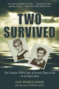
Book, G. P. Jones, Two Survived, 1941
On August 21, 1940, a Nazi raider torpedoed the British merchantman Anglo-Saxon and machine-gunned the survivors as they tried to escape in their lifeboats. One little boat escaped with seven men. Five of them perished, but Robert Tapscott and Wilbert Widdicombe endured for seventy full days and 2,300 miles to landfall on the other side of the Atlantic. This is the incredible account of their ordeal, one of the most thrilling stories of the sea ever written--and one that almost never came to light. "It has seldom happened," writes William McFee in the introduction, "that a narrative so circumstantial, so entirely stripped of all humbug and false sentiment, has come out of the depths of the sea, to inspire us with admiration for human valor." In the tradition of the Shackleton adventure and Nathaniel Philbrick's In the Heart of the Sea, Two Survived is an unforgettable true story of survival against the very longest odds.non-fictionOn August 21, 1940, a Nazi raider torpedoed the British merchantman Anglo-Saxon and machine-gunned the survivors as they tried to escape in their lifeboats. One little boat escaped with seven men. Five of them perished, but Robert Tapscott and Wilbert Widdicombe endured for seventy full days and 2,300 miles to landfall on the other side of the Atlantic. This is the incredible account of their ordeal, one of the most thrilling stories of the sea ever written--and one that almost never came to light. "It has seldom happened," writes William McFee in the introduction, "that a narrative so circumstantial, so entirely stripped of all humbug and false sentiment, has come out of the depths of the sea, to inspire us with admiration for human valor." In the tradition of the Shackleton adventure and Nathaniel Philbrick's In the Heart of the Sea, Two Survived is an unforgettable true story of survival against the very longest odds.ww2, survivors, german submarines, robert tapscott, wilbert widdicombe -
Glenelg Shire Council Cultural Collection
Book, Ivanhoe (Abridged), c. 1914
Ivanhoe is the story of one of the remaining Anglo-Saxon noble families at a time when the nobility in England was overwhelmingly Norman. It follows the Saxon protagonist, Sir Wilfred of Ivanhoe, who is out of favour with his father for Sir Wilfred's allegiance to the Norman king Richard the Lionheart.Novel, 'Ivanhoe' by Sir Walter Scott. Tan hard cover, black print and decorationIvanhoe is the story of one of the remaining Anglo-Saxon noble families at a time when the nobility in England was overwhelmingly Norman. It follows the Saxon protagonist, Sir Wilfred of Ivanhoe, who is out of favour with his father for Sir Wilfred's allegiance to the Norman king Richard the Lionheart. -
 Federation University Historical Collection
Book - Ledger, Ballarat School of Mines Assay and Analysis Ledger, 1887-1890, 1887-1890
The Ballarat School of Mines had a 'Model Mine' that was used to teach students. Practical work was undertaken for a fee, supervised by laboratory superintendents. Copies of assays undertaken are compiled together in this book. Leatherbound ledger with transfer copies assay reports from the Ballarat School of Mines. Those seeking assaying work from the Ballarat School of Mines are listed in alphabetical order in the front of the ledger. The ledger contains 543 pages. .2) Foolscap assay report on foolscap Ballarat School of Mines letterhead, and signed by Alfred Mica Smith, Superintendent of Laboratories. The report was on eight samples of Quartz submitted by R.C. Morgan, Scotts, Hotel, Melbourne .3) Assay report on Ballarat School of Mines letterhead, dated 14 August 1985, and signed by Andrew Berry, Registrar. The assay was supervised by Professor Alfred Mica Smith, and undertaken for James Burke, Broken Hill, New South Wales. .4) Assay report on Ballarat School of Mines letterhead, dated 18 August 1988, and signed by Alfred Mica Smith, Superintendent of Laboratories. The assay was undertaken on samples of Limonite submitted by James Burke and others, Broken Hill, New South Wales. The report includes information the the Ballarat School of Mines museum and the search for geological specimens from all Australian colonies for the collection. .5) A 'rough' assay report on samples of stone submitted by H. Major Senr, Wilcannia, New South Wales. 5) A 'rough' assay report on sample quartz drillings from quartz reef submitted by H. Morris, Egerton, and an sample of quartz and pyrites for determination by Professor Krause submitted by R.M. Serjeant. ballarat school of mines, a.c. allan, brittania g.m. co., s. body, black horse company, john m. bickett, william bell, james barker, w. bliss, w. bailey, william barrou, w.h. batten, w. bechervaise, band and albion, budd bros, charles barker, i. cahir, a. chamber, w. cahill, james coglan, d. clarke, a.w. dobbie, john dosett, john dunstan, j.a. evans, l. eggleton, charles forbes, d. fitzpatrick, e. ford, michael goold, j. graham, john greenwood, james hayes, ed hardy, arthur harvey, george hodges, john hall, jubilee gold mining company, krause, luplau, lempiere, mt lyell co, john law, ed meadway, john murray, j.h. middleton, c.m. miles, m. muir, e. mcmillan, w. mcdougall, c. napier, w.r. nicholls, napier freehold, w.b, ochiltree, oakleigh gold mining company, dr pinnock, c. quin, james ross, c.b. retallack, e. rowlands, royal standard, linton, frank rabling, william russell, charles soloman, f. selby, w.j. scott, sulieman pasha co, south clunes united, h.w. sinclair, george selby, e.h. schroeder, horsham, e.w. spain, c.h. sheary, sir henry loch gold mining company, a. sutherland, saxon consols, j.b. triggs, h. townsend, harold turnley, c. taylor, melbourne, c. thorpe, a. vandenberg, charles walker, charles wilson, thomas wellington, a. wynne, r. warne, e. wattis, john wood, walter warner, armidale, c. winterbottom, w.l. willliams, j.c. young -
 Bendigo Historical Society Inc.
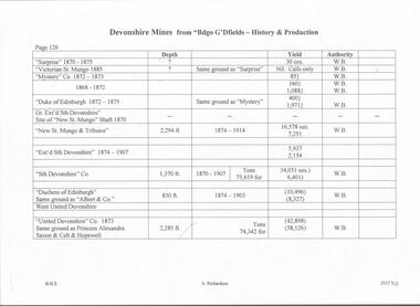
Document - DEVONSHIRE MINES - DEVONSHIRE MINES PRODUCTION
Hand written notes on Devonshire Mines mentioning name of mine, years of operating, depth, yield and authority.mine, gold, devonshire mines, devonshire mines, bendigo goldfields - history & production, surprise, victorian st mungo, mystery co, duke of edinburgh, gt ext'd sth devonshire, new st mungo shaft, new st mungo, ext'd sth devonshire, sth devonshire co, duchess of edinburgh, albert & coy, west united devonshire, united devonshire co, princess alexandria, saxon & celt & hopewell -
 Bendigo Historical Society Inc.
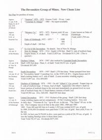
Document - DEVONSHIRE MINES - NOTES ON THE DEVONSHIRE GROUP OF MINES
Carbon copy of notes on the Devonshire Group of Mines - New Chum Line. Notes mention mines, years of operating, location in relation to other mines in the group, yields, dividends and depth of shafts. Some give locations in relationship to streets, etc. Signed by A. Richardson.mine, gold, devonshire mines, devonshire mines, new chum line, surprise, victorian st. mungo, mystery co., duke of edinburgh, gt ext'd st devonshire, new st mungo, duchess tribute, extended south devonshire, south devonshire, devonshire sands cyaniding coy, duchess of edinburgh, albert's coy, old albert's shaft, united devonshire, freeman & coy, the danes, west united devonshire, hopewell, phoenix, extended st mungo, princess alexandra, saxon & celt coys, east devonshire, sheepshead line, new st mungo east shaft, gt. extended hustlers -
Victorian Aboriginal Corporation for Languages
DVD, Rachel Perkins, First Australians - the untold story of Australia, 2008
Chronicles the birth of contemporary Australia as never told before, from the perspective of the country's First Peoples. The series explores what unfolds when the oldest living culture in the world is overrun by the world's greatest empire. Over seven episodes, First Australians depicts the true stories of individuals - both black and white - caught in an epic drama of friendship, revenge, loss and victory in Australia's most transformative period of history. The story begins in 1788 in Sydney, with the friendship between an Englishmen (Governor Phillip) and a warrior (Bennelong) and ends in 1993 with Koiki Mabo's legal challenge to the foundation of Australia. First Australians chronicles the collision of two worlds and the genesis of a new nation.DVD, bonus study guide -
Victorian Aboriginal Corporation for Languages
DVD, Suzy Bates, Nothing rhymes with Ngapartji, 2010
Nothing Rhymes with Ngapartji follows the journey of acclaimed Pitjantjatjara actor Trevor Jamieson, as he returns to his traditional country to perform his hit stage show Ngapartji Ngapartji to an all-Indigenous audience in the remote Australian Aboriginal community of Ernabella, South Australia. Nothing Rhymes with Ngapartji is a film about performing a multi-faceted drama to audiences who speak different languages, who are of different cultures and who have varying expectations. Offers an insight into Indigenous perspectives on the consequences of white settlement for Aboriginal cultures. In presenting the material in both Pitjantjatjara and English, it raises the important issue of stories needing to be told in languages that are central to different Australians' understanding of the world. The film is part of Big hART?s Ngapartji Ngapartji project, which is a collaborative work in progress between Indigenous and white Australians that pools their skills, experiences and resources to tell an important story about Indigenous history, culture, language and the experience of several generations.DVD, online study guidepitjantjatjara, theatre, music performance, big hart -
 Victorian Aboriginal Corporation for Languages
DVD, Oxfam Australia, Close the gap, 2008
-
 Victorian Aboriginal Corporation for Languages
DVD, Indigenous Community Television, Showing Our Way, 2003
Mostly Pilbara and Kimberley Aboriginal Media (PAKAM) programs showing aboriginal lifestyle, culture (traditional dances, painting) and sport.DVD