Showing 514 items matching " street directory"
-
 Whitehorse Historical Society Inc.
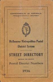
Book, Melbourne Metropolitan Postal District System, 1936
... This street directory was used at the Mitcham Post Office... Mitcham melbourne This street directory was used at the Mitcham ...96 page book of street addresses throughout Melbourne used by Post Office Communicationsnon-fiction96 page book of street addresses throughout Melbourne used by Post Office Communicationspostal services, street directories, mitcham post office -
 University of Melbourne, Burnley Campus Archives
Plan, Swinburne College of Technology Ltd. Detail Survey of Willsmere Park, 1978-c.1987
... of page from Melways street directory showing location of park..., B.S. Ooi, D.Ong. Photocopy of page from Melways street ...Plan dated 27.10.1978 for Swinburne College of Technology Ltd. With updated handwritten notes post 1978, imcluding 1987 flood level, by T.Smith, B. Jones, B.S. Ooi, D.Ong. Photocopy of page from Melways street directory showing location of parkswinburne college of technology, willsmere park, t.smith, b. jones, b.s. ooi, d.ong, kew east -
Glenelg Shire Council Cultural Collection
Book, E.N.T. HENRY, Historic Portland Street Names, 1972
... Cliff Street Portland great-ocean-road local history street ...Book of historic Portland street names, including their origin, location and significance. A street map of Portland is attached to inside of back cover. Semi gloss card covers, grey with red and blue print. Inside pages pale yellow, black print. Map of Portland white with black print.local history, street names, portland, directory -
 Bendigo Historical Society Inc.
Document - LONG GULLY HISTORY GROUP COLLECTION: LONG GULLY NAMES STREET BY STREET
... photocopied from a street directory. Date unknown.... have been photocopied from a street directory. Date unknown ...Five pages of copies of residents of streets in Long Gully including Derwent Gully, Sparrowhawk and St Just Point. Numbers beside names are possibly street numbers. Street names have E Side, W Side, N Side or South Side. These pages have been photocopied from a street directory. Date unknown.bendigo, history, long gully history group, the long gully history group - long gully residents street by street, derwent gully, sparrowhawk, st just point -
 Surrey Hills Historical Society Collection
Compact disc, Victorian Directory 1916-1920 (Sands & McDougall) (5 discs)
... the following sub-directories: city streets Directory: with a street... the following sub-directories: city streets Directory: with a street... comprehensive containing the following sub-directories: city streets ...The Sands and McDougall directories are amongst the most comprehensive. You can find out more details about places in which people lived, the other residents in the area, the services available in the region...all of which help to paint a picture of your ancestors' life. Apart from the Street,Alphabetical, Trade and Professional directories, this volume also contains Government and Official, Ecclesiastical, Legal, Municipal, Colonial, Societies and Institutions directories. This compendium of Sands and McDougall's directories covers 1916-1920. Each is very comprehensive containing the following sub-directories: city streets Directory: with a street index, and street by street listings of all houses and the householder at each address. Country directory: that lists people alphabetically for each town and their occupation. Alphabetical Directory: covering the whole of Victoria. Melbourne and Suburban Professional & Trade Directory: listing people by their trade. Country Professional & Trade Directory: complements the Melbourne list to give coverage of all Victoria. It also includes Agriculture and Pastoral; Government and Official; Legal and Judicial including Justices of the Peace; Ecclesiastical.The Sands and McDougall directories are amongst the most comprehensive. You can find out more details about places in which people lived, the other residents in the area, the services available in the region...all of which help to paint a picture of your ancestors' life. Apart from the Street,Alphabetical, Trade and Professional directories, this volume also contains Government and Official, Ecclesiastical, Legal, Municipal, Colonial, Societies and Institutions directories. This compendium of Sands and McDougall's directories covers 1916-1920. Each is very comprehensive containing the following sub-directories: city streets Directory: with a street index, and street by street listings of all houses and the householder at each address. Country directory: that lists people alphabetically for each town and their occupation. Alphabetical Directory: covering the whole of Victoria. Melbourne and Suburban Professional & Trade Directory: listing people by their trade. Country Professional & Trade Directory: complements the Melbourne list to give coverage of all Victoria. It also includes Agriculture and Pastoral; Government and Official; Legal and Judicial including Justices of the Peace; Ecclesiastical.streets, trade, agriculture, government, legal, ecclesiastical, farmers, farm workers, clergy -
 Ballarat Tramway Museum
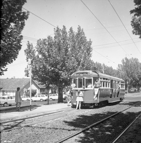
Photograph - Black & White Photograph/s, 1970's?
... Melbourne Street Directory, 21st edition.... Melway Melbourne Street Directory, 21st edition. Photograph Black ...Black and white photograph of L 104 in Dandenong Road Prahran, at tram stop 35 while on a special tour with a signalised intersection behind - Melway shows it as Orrong Road, Prahran. Tram showing destination of "SPECIAL". Possibly taken during the mid 1970's - see also item 1314, possibly on the same tour given the hair styles and skirt lengths. See Melway Melbourne Street Directory, 21st edition.trams, tramways, l class, dandenong road, melbourne, mmtb, tram 104 -
 Melbourne Tram Museum
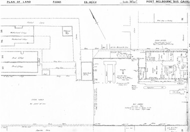
Drawing, Melbourne & Metropolitan Tramways Board (MMTB), "Port Melbourne Bus Garage", c1938
... Melway Street Directory No. 1 from Kevin Staines 24-2-2018... Melway Street Directory No. 1 from Kevin Staines 24-2-2018 ...Set of five photocopied plans or drawings on A3 sheets of the "Port Melbourne Bus Garage" .1 - P8383 - Plan showing building layouts and adjacent land - including a Poultry Farm - dated 1938 .2 - P8416 - Plan showing parts of the adjoining properties including houses. .3 - Unnumbered - more modern architects drawing showing details of offices - c1944? - two sheets. .4 - unnumbered - drawing showing layout of repair shed, pits, offices and mess room facing Bay St. Copy of the map from Melway Street Directory No. 1 from Kevin Staines 24-2-2018 - added 9-3-2018. See image i6trams, tramways, drawings, depots, property, port melbourne, buses, maps -
 Bendigo Historical Society Inc.
Document - VARIOUS DOCUMENTS FROM 'BOX 511'
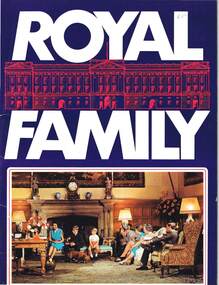
... (street directory), 1954 - ex libris A. Richardson, 1959; I... (street directory), 1954 - ex libris A. Richardson, 1959; I ...Various documents from 'Box 511': a. 'Royal Family' - re filmed portrait of Queen Elizabeth II (1959); b. 'Scientific American', issue of April 1934; c. 'Band of Hope Review, 1867 - published in England (Baptist); d. 'Beautiful Britain' - Art Series No 6 - Scenery of the United Kingdom, m1894; e. as for d. but Series 10; f. as for d. but Series 11; g. as for d. but Series unknown (no cover); h. 'Hobart and Suburbs' = Aerial Survey Maps (street directory), 1954 - ex libris A. Richardson, 1959; I. 'Weekly Times Annual, Dec 10, 1931 - cover and pages missing; j. 'Table Talk Christmas Annual, Dec 3, 1923 (cover and pages missing)document -
 Bendigo Historical Society Inc.
Book - SANDS AND MCDOUGALLS MELBOURNE SUBURBAN AND COUNTRY DIRECTORY FOR 1903, 1903
... Hard cover book containing a directory of street... and McDougall Hard cover book containing a directory of street ...BHS CollectionHard cover book containing a directory of street, alphabetical trade and professional people of Melbourne and suburbs. Also contains Government, ecclesiastical, legal official, municipal and miscellaneous information. Also contains a country section with street, trade and professional directories and the names of leading professional men, persons in trade and storekeepers in the principal towns in the State of Victoria.Sands and McDougallbook, directory, melbourne, victoria -
 Hume City Civic Collection
Photograph, Late 1980's
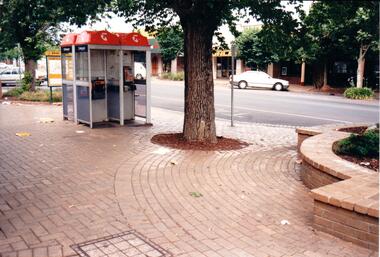
... rank in Evans Street. The telephone directories have been torn... Street. The telephone directories have been torn up an thrown ...The series of seven photographs highlight examples of vandalism within the town centre precinct. Most of the vandalism occurred on public buildingsA coloured photograph of public telephones and the taxi rank in Evans Street. The telephone directories have been torn up an thrown around the brick pavement along with other litter. The trunk of an elm tree is in the middle of the photograph.vandalism, evans street, taxi ranks, public telephones, telstra, telecom, george evans collection -
 Bendigo Historical Society Inc.
Photograph - WES HARRY COLLECTION: PROFESSOR MANNING-CLARK, 1973
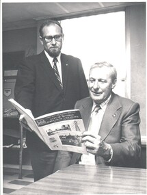
... a copy of the ' City of Bendigo and Borough of Eaglehawk, Street... Inc. History House 11 Mackenzie Street Bendigo goldfields ...Black and white photograph of Professor Manning - Clark (standing) and an unknown Gentleman (seated). They are studying a copy of the ' City of Bendigo and Borough of Eaglehawk, Street maps and Business Directory.Bendigo Advertiserperson, group, business, professor manning clark -
 Surrey Hills Historical Society Collection
Compact disc, Victorian Directory 1921-1925 (Sands & McDougall) (5 discs)
... the following sub-directories: city streets Directory: with a street... comprehensive containing the following sub-directories: city streets ...The Sands and McDougall directories are amongst the most comprehensive. You can find out more details about places in which people lived, the other residents in the area, the services available in the region...all of which help to paint a picture of your ancestors' life. Apart from the Street,Alphabetical, Trade and Professional directories, this volume also contains Government and Official, Ecclesiastical, Legal, Municipal, Colonial, Societies and Institutions directories. This compendium of Sands and McDougall's directories covers 1916-1920. Each is very comprehensive containing the following sub-directories: city streets Directory: with a street index, and street by street listings of all houses and the householder at each address. Country directory: that lists people alphabetically for each town and their occupation. Alphabetical Directory: covering the whole of Victoria. Melbourne and Suburban Professional & Trade Directory: listing people by their trade. Country Professional & Trade Directory: complements the Melbourne list to give coverage of all Victoria. It also includes Agriculture and Pastoral; Government and Official; Legal and Judicial including Justices of the Peace; Ecclesiastical.The Sands and McDougall directories are amongst the most comprehensive. You can find out more details about places in which people lived, the other residents in the area, the services available in the region...all of which help to paint a picture of your ancestors' life. Apart from the Street,Alphabetical, Trade and Professional directories, this volume also contains Government and Official, Ecclesiastical, Legal, Municipal, Colonial, Societies and Institutions directories.streets, trade, agriculture, government, legal, ecclesiastical, farmers, farm workers, clergy -
 Surrey Hills Historical Society Collection
Compact disc, Victorian Directory 1926-1930 (Sands & McDougall) (5 discs)
... the following sub-directories: city streets Directory: with a street... comprehensive containing the following sub-directories: city streets ...The Sands and McDougall directories are amongst the most comprehensive. You can find out more details about places in which people lived, the other residents in the area, the services available in the region...all of which help to paint a picture of your ancestors' life. Apart from the Street,Alphabetical, Trade and Professional directories, this volume also contains Government and Official, Ecclesiastical, Legal, Municipal, Colonial, Societies and Institutions directories. This compendium of Sands and McDougall's directories covers 1916-1920. Each is very comprehensive containing the following sub-directories: city streets Directory: with a street index, and street by street listings of all houses and the householder at each address. Country directory: that lists people alphabetically for each town and their occupation. Alphabetical Directory: covering the whole of Victoria. Melbourne and Suburban Professional & Trade Directory: listing people by their trade. Country Professional & Trade Directory: complements the Melbourne list to give coverage of all Victoria. It also includes Agriculture and Pastoral; Government and Official; Legal and Judicial including Justices of the Peace; Ecclesiastical.The Sands and McDougall directories are amongst the most comprehensive. You can find out more details about places in which people lived, the other residents in the area, the services available in the region...all of which help to paint a picture of your ancestors' life. Apart from the Street,Alphabetical, Trade and Professional directories, this volume also contains Government and Official, Ecclesiastical, Legal, Municipal, Colonial, Societies and Institutions directories.streets, trade, agriculture, government, legal, ecclesiastical, farmers, farm workers, clergy -
 Surrey Hills Historical Society Collection
Compact disc, Victorian Directory 1931 (Sands & McDougall)
... the following sub-directories: city streets Directory: with a street... comprehensive containing the following sub-directories: city streets ...The Sands and McDougall directories are amongst the most comprehensive. You can find out more details about places in which people lived, the other residents in the area, the services available in the region...all of which help to paint a picture of your ancestors' life. Apart from the Street,Alphabetical, Trade and Professional directories, this volume also contains Government and Official, Ecclesiastical, Legal, Municipal, Colonial, Societies and Institutions directories. This compendium of Sands and McDougall's directories covers 1916-1920. Each is very comprehensive containing the following sub-directories: city streets Directory: with a street index, and street by street listings of all houses and the householder at each address. Country directory: that lists people alphabetically for each town and their occupation. Alphabetical Directory: covering the whole of Victoria. Melbourne and Suburban Professional & Trade Directory: listing people by their trade. Country Professional & Trade Directory: complements the Melbourne list to give coverage of all Victoria. It also includes Agriculture and Pastoral; Government and Official; Legal and Judicial including Justices of the Peace; Ecclesiastical.The Sands and McDougall directories are amongst the most comprehensive. You can find out more details about places in which people lived, the other residents in the area, the services available in the region...all of which help to paint a picture of your ancestors' life. Apart from the Street,Alphabetical, Trade and Professional directories, this volume also contains Government and Official, Ecclesiastical, Legal, Municipal, Colonial, Societies and Institutions directories. This directory is divided into five main sections: City Strets Directory; Country Towns Directory; alphabetical Directory covering whole of Victoria; Melbourne and Suburban Professional and Trade Directory- listing people by their trade; Country Professional and Trade Directory which complements the Melbourne list togive coverage of all Victoria.streets, trade, agriculture, government, legal, ecclesiastical, farmers, farm workers, clergy -
 Surrey Hills Historical Society Collection
Compact disc, Victorian Directory 1933 (Sands & McDougall)
... the following sub-directories: city streets Directory: with a street... comprehensive containing the following sub-directories: city streets ...The Sands and McDougall directories are amongst the most comprehensive. You can find out more details about places in which people lived, the other residents in the area, the services available in the region...all of which help to paint a picture of your ancestors' life. Apart from the Street,Alphabetical, Trade and Professional directories, this volume also contains Government and Official, Ecclesiastical, Legal, Municipal, Colonial, Societies and Institutions directories. This compendium of Sands and McDougall's directories covers 1916-1920. Each is very comprehensive containing the following sub-directories: city streets Directory: with a street index, and street by street listings of all houses and the householder at each address. Country directory: that lists people alphabetically for each town and their occupation. Alphabetical Directory: covering the whole of Victoria. Melbourne and Suburban Professional & Trade Directory: listing people by their trade. Country Professional & Trade Directory: complements the Melbourne list to give coverage of all Victoria. It also includes Agriculture and Pastoral; Government and Official; Legal and Judicial including Justices of the Peace; Ecclesiastical.The Sands and McDougall directories are amongst the most comprehensive. You can find out more details about places in which people lived, the other residents in the area, the services available in the region...all of which help to paint a picture of your ancestors' life. Apart from the Street,Alphabetical, Trade and Professional directories, this volume also contains Government and Official, Ecclesiastical, Legal, Municipal, Colonial, Societies and Institutions directories.streets, trade, agriculture, government, legal, ecclesiastical, farmers, farm workers, clergy -
 Surrey Hills Historical Society Collection
Compact disc, Victorian Directory 1935(Sands & McDougall)
... the following sub-directories: city streets Directory: with a street... comprehensive containing the following sub-directories: city streets ...The Sands and McDougall directories are amongst the most comprehensive. You can find out more details about places in which people lived, the other residents in the area, the services available in the region...all of which help to paint a picture of your ancestors' life. Apart from the Street,Alphabetical, Trade and Professional directories, this volume also contains Government and Official, Ecclesiastical, Legal, Municipal, Colonial, Societies and Institutions directories. This compendium of Sands and McDougall's directories covers 1916-1920. Each is very comprehensive containing the following sub-directories: city streets Directory: with a street index, and street by street listings of all houses and the householder at each address. Country directory: that lists people alphabetically for each town and their occupation. Alphabetical Directory: covering the whole of Victoria. Melbourne and Suburban Professional & Trade Directory: listing people by their trade. Country Professional & Trade Directory: complements the Melbourne list to give coverage of all Victoria. It also includes Agriculture and Pastoral; Government and Official; Legal and Judicial including Justices of the Peace; Ecclesiastical.The Sands and McDougall directories are amongst the most comprehensive. You can find out more details about places in which people lived, the other residents in the area, the services available in the region, all of which help to paint a picture of your ancestors' life. Apart from the Street,Alphabetical, Trade and Professional directories, this volume also contains Government and Official, Ecclesiastical, Legal, Municipal, Colonial, Societies and Institutions directories.streets, trade, agriculture, government, legal, ecclesiastical, farmers, farm workers, clergy -
 Surrey Hills Historical Society Collection
Compact disc, Victorian Directory 1938 (Sands & McDougall)
... the following sub-directories: city streets Directory: with a street... comprehensive containing the following sub-directories: city streets ...The Sands and McDougall directories are amongst the most comprehensive. You can find out more details about places in which people lived, the other residents in the area, the services available in the region...all of which help to paint a picture of your ancestors' life. Apart from the Street,Alphabetical, Trade and Professional directories, this volume also contains Government and Official, Ecclesiastical, Legal, Municipal, Colonial, Societies and Institutions directories. This compendium of Sands and McDougall's directories covers 1916-1920. Each is very comprehensive containing the following sub-directories: city streets Directory: with a street index, and street by street listings of all houses and the householder at each address. Country directory: that lists people alphabetically for each town and their occupation. Alphabetical Directory: covering the whole of Victoria. Melbourne and Suburban Professional & Trade Directory: listing people by their trade. Country Professional & Trade Directory: complements the Melbourne list to give coverage of all Victoria. It also includes Agriculture and Pastoral; Government and Official; Legal and Judicial including Justices of the Peace; Ecclesiastical.The Sands and McDougall directories are amongst the most comprehensive. You can find out more details about places in which people lived, the other residents in the area, the services available in the region...all of which help to paint a picture of your ancestors' life. Apart from the Street, Alphabetical, Trade and Professional directories, this volume also contains Government and Official, Ecclesiastical, Legal, Municipal, Colonial, Societies and Institutions directories.streets, trade, agriculture, government, legal, ecclesiastical, farmers, farm workers, clergy -
 Surrey Hills Historical Society Collection
Compact disc, Victorian Directory 1942 (Sands & McDougall)
... the following sub-directories: city streets Directory: with a street... comprehensive containing the following sub-directories: city streets ...The Sands and McDougall directories are amongst the most comprehensive. You can find out more details about places in which people lived, the other residents in the area, the services available in the region...all of which help to paint a picture of your ancestors' life. Apart from the Street,Alphabetical, Trade and Professional directories, this volume also contains Government and Official, Ecclesiastical, Legal, Municipal, Colonial, Societies and Institutions directories. This compendium of Sands and McDougall's directories covers 1916-1920. Each is very comprehensive containing the following sub-directories: city streets Directory: with a street index, and street by street listings of all houses and the householder at each address. Country directory: that lists people alphabetically for each town and their occupation. Alphabetical Directory: covering the whole of Victoria. Melbourne and Suburban Professional & Trade Directory: listing people by their trade. Country Professional & Trade Directory: complements the Melbourne list to give coverage of all Victoria. It also includes Agriculture and Pastoral; Government and Official; Legal and Judicial including Justices of the Peace; Ecclesiastical.The Sands and McDougall directories are amongst the most comprehensive. You can find out more details about places in which people lived, the other residents in the area, the services available in the region...all of which help to paint a picture of your ancestors' life. Apart from the Street,Alphabetical, Trade and Professional directories, this volume also contains Government and Official, Ecclesiastical, Legal, Municipal, Colonial, Societies and Institutions directories.streets, trade, agriculture, government, legal, ecclesiastical, farmers, farm workers, clergy -
Glen Eira Historical Society
Document - Bambra Road Methodist Church, Northcote Avenue
... By Claire Barton Dated 07/05/2010 With Street And Directory.... Also Brief Note By Claire Barton Dated 07/05/2010 With Street ...Photocopy Of A 2 Page Extract From A Coming Together Book Compiled By Gwenda Mann Describing The History Of Bambra Road Methodist Church. It Contains Information From 75 Years At St Stephen’s Caulfield, Including Union With Bambra Road Methodist Church By Della Hilton, 1985. A Photograph Of Several Small Extracts From This Publication Is Also Included. Also Brief Note By Claire Barton Dated 07/05/2010 With Street And Directory References.bambra road, bambra road methodist church, caulfield north, everett l.d., st stephen’s presbyterian church caulfield, alday thomas rev, everett win, bambra road trustees, alday thomas mrs, everett keith, caulfield park, caulfield park bowling club, heazlewood vere, goddard sydney, smith ray j. m., hilton della, northcote avenue, pask n. h., goff j. t. j, talbot n. e. g, lavender j. c., o’ connor t. m., smith r. j. m, selomb h. w., hawkins h. l, freeman j. t., mannering c. w. j., gray n. a., weatherlake r. c., croxford r. l. g., wilson g. rev., small h. rev., dunstan a. rev., caulfield methodist circuit, caulfield council, anderson mrs., caulfield north, religious groups, methodist church, uniting church, clergy, sunday schools, organs, church furniture, stained glass. -
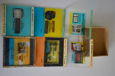 Warrnambool and District Historical Society Inc.
Glass Slides, Alex Gunn & Sons, 1930s-1950s
... . The company also produced the Morgans Street Directory for over 50.... The company also produced the Morgans Street Directory for over 50 ...These slides have been made by Alex Gunn and Sons, a 20th century lantern and slide maker based in Melbourne. The slides were produced for Val Morgan and Sons, a cinema advertising slide maker. Val (Valentine) Morgan (1867-1952) established a business in 1894 and by 1914 was making slides for cinemas. By 1921 the business was a company producing slides for movie houses and by the 1930s was the largest business of its type in Victoria. The company also produced the Morgans Street Directory for over 50 years in the 20th century. The company was sold in 1987. It is believed that these slides were shown in the Capitol Theatre in Warrnambool as the advertisements feature a local business, Fletts Plumbing. Most of the slides advertise Metters and Everhot bathroom and kitchen appliances, obtainable from the Warrnambool firm, going under the various trade names of Flett Brothers, F. Flett and Co and Fletts of 147 Lava Street (with ‘Lava’ spelt as ‘Laver’ in one ad). John Flett, boat and bridge builder, settled in Warrnamool in 1868 and it was his son William who first established a tinsmith and plumbing business in Warrnambool in the 1880s in a shop in Timor Street. His sons, Frederick and Charles, continued on the business after the father’s death in a Lava Street site until its demise in the 1950s. These items are of great interest as examples of cinema advertising slides used in cinemas in the mid 20th century and perhaps in the 1930s. The items have local significance as the slides feature advertisements for the business of the Flett family who were local plumbers and fitters. The slides are also of local interest as they are believed to have been used in the Capitol Theatre in Kepler Street, still operating today. These are eleven glass slides produced for cinema advertising in the mid 20th century. Three of the slides are blank and eight contain coloured images and printing advertising the products of kitchen and bathroom items and the local Warrnambool supplier. Four of the slides have thicker glass and four have paper labelling on the top and bottom edges. The slides are held in a cardboard box without a lid.Val Morgan & Sons Pty Ltd Reg. Office 64 Elizabeth Street Melbourne Please screen at least 12 SECONDS Gunn Slide flett family, plumbers, warrnambool, val morgan & sons cinema slides -
 Surrey Hills Historical Society Collection
Photograph, Mrs Florence Margaret Tacey (nee Edwards)
... and the Sands & MacDougall street directory indicates that a butcher’s... was a butcher and the Sands & MacDougall street directory indicates ...Mrs Florence Margaret Tacey (nee Edwards) was the mother of Albert Arthur Tacey. She was born in 1863; died in 1943 in Camberwell. Her husband was William Tacey born in the Buckland Valley near Bright in 1857. There were many members of the Tacey family who were butchers. Various members of the family were associated with Tacey's Butchers at 629 Canterbury Road, Surrey Hills. According to a Context P/L heritage assessment of the property the land on which the business was built "was purchased by Edward Tacey on 16 September 1889. Edward Tacey was a butcher and the Sands & MacDougall street directory indicates that a butcher’s shop had been constructed on the site and was operating by 1890. It seems that the family lived for some time at a house located next door to the shop at 627 Canterbury Road (visible on the 1909 MMBW plan, but since demolished). On 15 June 1920 Edward Tacey transferred all three blocks of land to Joseph Tacey, most likely his son * and also a butcher, who carried on business from the same premises. Joseph Tacey died on 20 February 1933, after which administration of his estate (which included the three blocks of land) passed to his widow, Mary Dorothy Tacey." Edward Tacey (1863 - 1952) was the brother of William Tacey (1857 - 1920). The property passed to Joseph Charles Tacey (1887 - 1933), his nephew and son of William, not his son. His wife was Mary Dorothy Coates. Albert Arthur Tacey was a brother of Joseph Charles Tacey. The SHNCHC has a large framed photo collage of the Tacey butcher's shop at 629 Canterbury Road. It hung in various Tacey family-owned butcher's shops around Victoria before coming back to Surrey Hills. The donor was the daughter of Albert Arthur Tacey (1902-1959). A black and white photograph of an older lady. She has greying hair, is wearing rimless glasses, pearls and a jacket over her dress.surrey hills, butchers, mrs florence margaret tacey, miss florence margaret edwards, william tacey, joseph charles tacey, albert arthur tacey -
 Surrey Hills Historical Society Collection
Photograph, Mr and Mrs William Tacey
... was a butcher and the Sands & MacDougall street directory indicates... directory entries are in 1888 & 1889 for the Surrey Hills shop ...William (1857 - 1920) was a butcher. William was born 7 Nov 1857 on the Buckland (River) near Bright, son of John Joseph Tacey and wife Elizabeth Cooper. This was just a few months after the Buckland River anti-Chinese riots. He had siblings Thomas (1856-1929), Mary Ann (1860-1920), Edward (1863-1952) and Arthur Edward (1870-1896). William died 30 March 1920, Camberwell. He married Florence Margaret Edwards in 1884. Both are buried in Box Hill Cemetery (CE-0162). They had 7 surviving children; 2 died in infancy. William was a butcher in Thornbury but moved to Camberwell with his brothers seeing the opportunity in the new suburbs. They set up shops in Canterbury Road, opposite Highfield Road, Surrey Hills; Burwood; corner of Elgar & Whitehorse Roads, opposite the Whitehorse Hotel and Canterbury Road, Surrey Hills just east of Surrey Hotel. The first directory entries are in 1888 & 1889 for the Surrey Hills shop & Elgar Road. In Surrey Hills a substantial property was developed on land which "was purchased by Edward Tacey on 16 September 1889. Edward Tacey was a butcher and the Sands & MacDougall street directory indicates that a butcher’s shop had been constructed on the site and was operating by 1890. It seems that the family lived for some time at a house located next door to the shop at 627 Canterbury Road (visible on the 1909 MMBW plan, but since demolished). On 15 June 1920 Edward Tacey transferred all three blocks of land to Joseph Tacey, most likely his son * and also a butcher, who carried on business from the same premises. Joseph Tacey died on 20 February 1933, after which administration of his estate (which included the three blocks of land) passed to his widow, Mary Dorothy Tacey." (Context P/L Heritage Assessment) Correction: *Edward Tacey (1863 - 1952) was the brother of William Tacey (1857 - 1920). The property passed to Joseph Charles Tacey (1887 - 1933), his nephew and son of William, not his son. His wife was Mary Dorothy Coates. Albert Arthur Tacey was a brother of Joseph Charles Tacey. Edward later moved from the area and continued in the business in a number of regional Victorian centres. In Surrey Hills the business was continued by other members of the family including Albert Arthur Tacey (1902-1959) who lived at 7 Sunbury Crescent, and daughter Stella Florence Tacey and her husband Roy Morris and their son Harry Tacey Morris. The donor of the Tacey collection of photos was Elaine Merle Tacey (1925-2003), daughter of Albert Arthur Tacey. She married Donald McKenzie. A black and white photograph of a couple in the garden. The man is standing and wearing a 3 piece suit whilst the lady is seated and holding a posy of flowers in her lap.(mr) william tacey, butchers, (mr) edward tacey, (mr) thomas tacey, (mr) joseph tacey, (mrs) stella morris, (mr) roy morris, (miss) florence margaret edwards, (mrs) florence margaret tacey, (mr) albert arthur tacey, (miss) stella tacey, (mr) harry tacey morris -
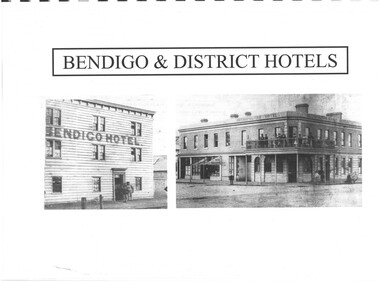 Bendigo Historical Society Inc.
Document - INDEXES
... McConnell’s Street and general Directory Date unknown Victorian... Street and general Directory Date unknown Victorian Directory ...Indexes Includes Names from the 1856 Petition Bendigo and District Hotels Final Marunari List Terry Davidson 1871 - 2018 Index to RHSV Bendigo Branch Newsletters Nov. 1971 - July 2002 Helen Mainka 1954 Bendigo Business District Directory McConnell’s Street and general Directory Date unknown Victorian Directory 1904 Bendigo and District Directory 1904 – 1905 Bendigo district general Directory 1859 City of Bendigo Historical Information Bendigo Hotels compiled by Len Bennetts Hotels of Bendigo and District Compiled by Len Bennetts Sandhurst Land Sales 1854 – 1856 Ralph Birrell Chronicles of Bendigo from the Bendigo Advertiser Christmas Supplement December 22 1904 Some Photographers 1850 – 1900. Including some Bendigo Photographers 1854 – 1958 St. Patrick’s Annual Sports advertisers. Date Unknown Fatalities listed in bendigo Advertiser 1888-1935. Two copies One by year. One alphabetical. District statistics - Mayors and Shire Presidents, Bendigo Football League Premiers 1880- 1987, Sportstar of the year 1965-1987 Plans of townships and Parishes held at Ducley House. From the Bendigo Lands Office 1976. -
 Eltham District Historical Society Inc
Photograph, Looking north across the Fitzsimons Lane Bridge over Yarra River between Eltham and Templestowe, c.1985, 1985c
... as the Eltham-Templestowe Road. The 1966 Melway street directory... as the Eltham-Templestowe Road. The 1966 Melway street directory ...Turnoff to Candlebark Park on right. The bridge over the Yarra River was initially opened September 22nd, 1961. Newspaper reports at the time of opening stated it linked Bolton Street, Eltham, with Fitzsimons Lane, Templestowe. In 1955 the Country Roads Board (CRB) produced survey plans that showed proposed land acquisition for the future bridge and road approaches. The 1955 plan shows that it was proposed to connect Fitzsimons Lane with Bolton Street in Eltham by a diagonal road across the river. The road connection would then continue along Bolton Street to Main Road. Prior to construction of the bridge the CRB modified the proposal significantly so that there was a new road parallel with Bolton Street and then curving to join Main Road at what was then its intersection with Old Eltham Road. This involved significantly more land acquisition and altered the pattern of land subdivision through this corridor. Initially the new road was just a single two-way carriageway as it would have required a significant widening of the cutting on the Shire of Eltham side of the river. The road was officially un-named but was known locally as the Eltham-Templestowe Road. The 1966 Melway street directory and other 1960s editions also listed the road as the Eltham-Templestowe Road. In December 1970, Eltham Shire Council, in pursuance of the provisions of the Local Government Act, named it Templestowe Road. The road was renamed Fitzsimons Lane around 1984 in conformity with the section south of the river. In 1991 a new bridge was built to the west of the original bridge. Fitzsimons Lane was widened to four traffic lanes although on the Eltham side this was done within the limits of the existing cutting. NEW BRIDGE STARTS THEM EXPLORING Without any fanfares, Country Roads Board workmen on Friday afternoon put the finishing touches to the approaches, removed the barricades, and let the traffic roll over the new Yarra bridge linking Bolton Street, Eltham, with Fitzsimons Lane, Templestowe. Over the week-end many “bridge watchers” who were making one of their periodic inspections of the progress on the new bridge found to their surprise that they could drive over it, so that people who had gone for a run out to Eltham suddenly found themselves wandering through Templestowe and Doncaster. By Monday the word of the bridge’s opening had got around sufficiently for many regular travellers to the city from Eltham and beyond to vary the monotony by going to town via Templestowe and Kew instead of through Heidelberg. They were surprised at the distances – about 3 ½ miles from Eltham to Templestowe, 6 miles from Eltham Shire hall to the Lower Heidelberg Road-Banksia Street intersection. NEW NEIGHBOURS For people on both sides of the river, the new bridge has turned distant friends into near neighbours. A Greensborough man on Sunday took 35 minutes to reach the home of a friend in East Doncaster, but the return trip over the new bridge took only 17 minutes. It will be some time yet before most people work out the possibilities in shorter and quicker trips form the north-eastern areas to the eastern and south-eastern suburbs. The coming of the warmer months will soon teach many, though the short cuts to Peninsular beaches and eastern suburban drive-ins. And before very long it is likely there will be a Tramways bus running from Templestowe to Eltham station. NEW BRIDGE STARTS THEM EXPLORING (1961, September 27). The Diamond Valley News (News clipping held in SEA_74-1_047) The previously un-named road between Main Road and Yarra River, Eltham South, east of Bolton Street was named Templestowe Road, December 15, 1970 NAMING OF STREETS AND ROADS. (1970, December 15). The Diamond Valley News (News clipping held in SEA_74-2_022)Colour photographinfrastructure, shire of eltham infrastructure, bridge, fitzsimons lane bridge, yarra river, candlebark park, red nose day -
 Eltham District Historical Society Inc
Photograph, Fitzsimons Lane Bridge over Yarra River between Eltham and Templestowe
... . The 1966 Melway street directory and other 1960s editions also.... The 1966 Melway street directory and other 1960s editions also ...The bridge over the Yarra River was initially opened September 22nd, 1961. Newspaper reports at the time of opening stated it linked Bolton Street, Eltham, with Fitzsimons Lane, Templestowe. In 1955 the Country Roads Board (CRB) produced survey plans that showed proposed land acquisition for the future bridge and road approaches. The 1955 plan shows that it was proposed to connect Fitzsimons Lane with Bolton Street in Eltham by a diagonal road across the river. The road connection would then continue along Bolton Street to Main Road. Prior to construction of the bridge the CRB modified the proposal significantly so that there was a new road parallel with Bolton Street and then curving to join Main Road at what was then its intersection with Old Eltham Road. This involved significantly more land acquisition and altered the pattern of land subdivision through this corridor. Initially the new road was just a single two-way carriageway as it would have required a significant widening of the cutting on the Shire of Eltham side of the river. The road was officially un-named but was known locally as the Eltham-Templestowe Road. The 1966 Melway street directory and other 1960s editions also listed the road as the Eltham-Templestowe Road. In December 1970, Eltham Shire Council, in pursuance of the provisions of the Local Government Act, named it Templestowe Road. The road was renamed Fitzsimons Lane around 1984 in conformity with the section south of the river. In 1991 a new bridge was built to the west of the original bridge. Fitzsimons Lane was widened to four traffic lanes although on the Eltham side this was done within the limits of the existing cutting. NEW BRIDGE STARTS THEM EXPLORING Without any fanfares, Country Roads Board workmen on Friday afternoon put the finishing touches to the approaches, removed the barricades, and let the traffic roll over the new Yarra bridge linking Bolton Street, Eltham, with Fitzsimons Lane, Templestowe. Over the week-end many “bridge watchers” who were making one of their periodic inspections of the progress on the new bridge found to their surprise that they could drive over it, so that people who had gone for a run out to Eltham suddenly found themselves wandering through Templestowe and Doncaster. By Monday the word of the bridge’s opening had got around sufficiently for many regular travellers to the city from Eltham and beyond to vary the monotony by going to town via Templestowe and Kew instead of through Heidelberg. They were surprised at the distances – about 3 ½ miles from Eltham to Templestowe, 6 miles from Eltham Shire hall to the Lower Heidelberg Road-Banksia Street intersection. NEW NEIGHBOURS For people on both sides of the river, the new bridge has turned distant friends into near neighbours. A Greensborough man on Sunday took 35 minutes to reach the home of a friend in East Doncaster, but the return trip over the new bridge took only 17 minutes. It will be some time yet before most people work out the possibilities in shorter and quicker trips form the north-eastern areas to the eastern and south-eastern suburbs. The coming of the warmer months will soon teach many, though the short cuts to Peninsular beaches and eastern suburban drive-ins. And before very long it is likely there will be a Tramways bus running from Templestowe to Eltham station. NEW BRIDGE STARTS THEM EXPLORING (1961, September 27). The Diamond Valley News (News clipping held in SEA_74-1_047) The previously un-named road between Main Road and Yarra River, Eltham South, east of Bolton Street was named Templestowe Road, December 15, 1970 NAMING OF STREETS AND ROADS. (1970, December 15). The Diamond Valley News (News clipping held in SEA_74-2_022)Black and white photographinfrastructure, shire of eltham infrastructure, bridge, fitzsimons lane bridge, yarra river -
 Eltham District Historical Society Inc
Photograph, Looking south across the Fitzsimons Lane Bridge over Yarra River between Eltham and Templestowe
... . The 1966 Melway street directory and other 1960s editions also.... The 1966 Melway street directory and other 1960s editions also ...The bridge over the Yarra River was initially opened September 22nd, 1961. Newspaper reports at the time of opening stated it linked Bolton Street, Eltham, with Fitzsimons Lane, Templestowe. In 1955 the Country Roads Board (CRB) produced survey plans that showed proposed land acquisition for the future bridge and road approaches. The 1955 plan shows that it was proposed to connect Fitzsimons Lane with Bolton Street in Eltham by a diagonal road across the river. The road connection would then continue along Bolton Street to Main Road. Prior to construction of the bridge the CRB modified the proposal significantly so that there was a new road parallel with Bolton Street and then curving to join Main Road at what was then its intersection with Old Eltham Road. This involved significantly more land acquisition and altered the pattern of land subdivision through this corridor. Initially the new road was just a single two-way carriageway as it would have required a significant widening of the cutting on the Shire of Eltham side of the river. The road was officially un-named but was known locally as the Eltham-Templestowe Road. The 1966 Melway street directory and other 1960s editions also listed the road as the Eltham-Templestowe Road. In December 1970, Eltham Shire Council, in pursuance of the provisions of the Local Government Act, named it Templestowe Road. The road was renamed Fitzsimons Lane around 1984 in conformity with the section south of the river. In 1991 a new bridge was built to the west of the original bridge. Fitzsimons Lane was widened to four traffic lanes although on the Eltham side this was done within the limits of the existing cutting. NEW BRIDGE STARTS THEM EXPLORING Without any fanfares, Country Roads Board workmen on Friday afternoon put the finishing touches to the approaches, removed the barricades, and let the traffic roll over the new Yarra bridge linking Bolton Street, Eltham, with Fitzsimons Lane, Templestowe. Over the week-end many “bridge watchers” who were making one of their periodic inspections of the progress on the new bridge found to their surprise that they could drive over it, so that people who had gone for a run out to Eltham suddenly found themselves wandering through Templestowe and Doncaster. By Monday the word of the bridge’s opening had got around sufficiently for many regular travellers to the city from Eltham and beyond to vary the monotony by going to town via Templestowe and Kew instead of through Heidelberg. They were surprised at the distances – about 3 ½ miles from Eltham to Templestowe, 6 miles from Eltham Shire hall to the Lower Heidelberg Road-Banksia Street intersection. NEW NEIGHBOURS For people on both sides of the river, the new bridge has turned distant friends into near neighbours. A Greensborough man on Sunday took 35 minutes to reach the home of a friend in East Doncaster, but the return trip over the new bridge took only 17 minutes. It will be some time yet before most people work out the possibilities in shorter and quicker trips form the north-eastern areas to the eastern and south-eastern suburbs. The coming of the warmer months will soon teach many, though the short cuts to Peninsular beaches and eastern suburban drive-ins. And before very long it is likely there will be a Tramways bus running from Templestowe to Eltham station. NEW BRIDGE STARTS THEM EXPLORING (1961, September 27). The Diamond Valley News (News clipping held in SEA_74-1_047) The previously un-named road between Main Road and Yarra River, Eltham South, east of Bolton Street was named Templestowe Road, December 15, 1970 NAMING OF STREETS AND ROADS. (1970, December 15). The Diamond Valley News (News clipping held in SEA_74-2_022)Black and white photographinfrastructure, shire of eltham infrastructure, bridge, fitzsimons lane bridge, yarra river -
 Eltham District Historical Society Inc
Photograph, Fitzsimons Lane Bridge over Yarra River between Eltham and Templestowe
... . The 1966 Melway street directory and other 1960s editions also.... The 1966 Melway street directory and other 1960s editions also ...The bridge over the Yarra River was initially opened September 22nd, 1961. Newspaper reports at the time of opening stated it linked Bolton Street, Eltham, with Fitzsimons Lane, Templestowe. In 1955 the Country Roads Board (CRB) produced survey plans that showed proposed land acquisition for the future bridge and road approaches. The 1955 plan shows that it was proposed to connect Fitzsimons Lane with Bolton Street in Eltham by a diagonal road across the river. The road connection would then continue along Bolton Street to Main Road. Prior to construction of the bridge the CRB modified the proposal significantly so that there was a new road parallel with Bolton Street and then curving to join Main Road at what was then its intersection with Old Eltham Road. This involved significantly more land acquisition and altered the pattern of land subdivision through this corridor. Initially the new road was just a single two-way carriageway as it would have required a significant widening of the cutting on the Shire of Eltham side of the river. The road was officially un-named but was known locally as the Eltham-Templestowe Road. The 1966 Melway street directory and other 1960s editions also listed the road as the Eltham-Templestowe Road. In December 1970, Eltham Shire Council, in pursuance of the provisions of the Local Government Act, named it Templestowe Road. The road was renamed Fitzsimons Lane around 1984 in conformity with the section south of the river. In 1991 a new bridge was built to the west of the original bridge. Fitzsimons Lane was widened to four traffic lanes although on the Eltham side this was done within the limits of the existing cutting. NEW BRIDGE STARTS THEM EXPLORING Without any fanfares, Country Roads Board workmen on Friday afternoon put the finishing touches to the approaches, removed the barricades, and let the traffic roll over the new Yarra bridge linking Bolton Street, Eltham, with Fitzsimons Lane, Templestowe. Over the week-end many “bridge watchers” who were making one of their periodic inspections of the progress on the new bridge found to their surprise that they could drive over it, so that people who had gone for a run out to Eltham suddenly found themselves wandering through Templestowe and Doncaster. By Monday the word of the bridge’s opening had got around sufficiently for many regular travellers to the city from Eltham and beyond to vary the monotony by going to town via Templestowe and Kew instead of through Heidelberg. They were surprised at the distances – about 3 ½ miles from Eltham to Templestowe, 6 miles from Eltham Shire hall to the Lower Heidelberg Road-Banksia Street intersection. NEW NEIGHBOURS For people on both sides of the river, the new bridge has turned distant friends into near neighbours. A Greensborough man on Sunday took 35 minutes to reach the home of a friend in East Doncaster, but the return trip over the new bridge took only 17 minutes. It will be some time yet before most people work out the possibilities in shorter and quicker trips form the north-eastern areas to the eastern and south-eastern suburbs. The coming of the warmer months will soon teach many, though the short cuts to Peninsular beaches and eastern suburban drive-ins. And before very long it is likely there will be a Tramways bus running from Templestowe to Eltham station. NEW BRIDGE STARTS THEM EXPLORING (1961, September 27). The Diamond Valley News (News clipping held in SEA_74-1_047) The previously un-named road between Main Road and Yarra River, Eltham South, east of Bolton Street was named Templestowe Road, December 15, 1970 NAMING OF STREETS AND ROADS. (1970, December 15). The Diamond Valley News (News clipping held in SEA_74-2_022)Black and white photographinfrastructure, shire of eltham infrastructure, bridge, fitzsimons lane bridge, yarra river -
 Eltham District Historical Society Inc
Photograph, Russell Yeoman, Fitzsimons Lane Bridge over Yarra River between Eltham and Templestowe, c.1970, 1970c
... . The 1966 Melway street directory and other 1960s editions also.... The 1966 Melway street directory and other 1960s editions also ...The bridge over the Yarra River was initially opened September 22nd, 1961. Newspaper reports at the time of opening stated it linked Bolton Street, Eltham, with Fitzsimons Lane, Templestowe. In 1955 the Country Roads Board (CRB) produced survey plans that showed proposed land acquisition for the future bridge and road approaches. The 1955 plan shows that it was proposed to connect Fitzsimons Lane with Bolton Street in Eltham by a diagonal road across the river. The road connection would then continue along Bolton Street to Main Road. Prior to construction of the bridge the CRB modified the proposal significantly so that there was a new road parallel with Bolton Street and then curving to join Main Road at what was then its intersection with Old Eltham Road. This involved significantly more land acquisition and altered the pattern of land subdivision through this corridor. Initially the new road was just a single two-way carriageway as it would have required a significant widening of the cutting on the Shire of Eltham side of the river. The road was officially un-named but was known locally as the Eltham-Templestowe Road. The 1966 Melway street directory and other 1960s editions also listed the road as the Eltham-Templestowe Road. In December 1970, Eltham Shire Council, in pursuance of the provisions of the Local Government Act, named it Templestowe Road. The road was renamed Fitzsimons Lane around 1984 in conformity with the section south of the river. In 1991 a new bridge was built to the west of the original bridge. Fitzsimons Lane was widened to four traffic lanes although on the Eltham side this was done within the limits of the existing cutting. NEW BRIDGE STARTS THEM EXPLORING Without any fanfares, Country Roads Board workmen on Friday afternoon put the finishing touches to the approaches, removed the barricades, and let the traffic roll over the new Yarra bridge linking Bolton Street, Eltham, with Fitzsimons Lane, Templestowe. Over the week-end many “bridge watchers” who were making one of their periodic inspections of the progress on the new bridge found to their surprise that they could drive over it, so that people who had gone for a run out to Eltham suddenly found themselves wandering through Templestowe and Doncaster. By Monday the word of the bridge’s opening had got around sufficiently for many regular travellers to the city from Eltham and beyond to vary the monotony by going to town via Templestowe and Kew instead of through Heidelberg. They were surprised at the distances – about 3 ½ miles from Eltham to Templestowe, 6 miles from Eltham Shire hall to the Lower Heidelberg Road-Banksia Street intersection. NEW NEIGHBOURS For people on both sides of the river, the new bridge has turned distant friends into near neighbours. A Greensborough man on Sunday took 35 minutes to reach the home of a friend in East Doncaster, but the return trip over the new bridge took only 17 minutes. It will be some time yet before most people work out the possibilities in shorter and quicker trips form the north-eastern areas to the eastern and south-eastern suburbs. The coming of the warmer months will soon teach many, though the short cuts to Peninsular beaches and eastern suburban drive-ins. And before very long it is likely there will be a Tramways bus running from Templestowe to Eltham station. NEW BRIDGE STARTS THEM EXPLORING (1961, September 27). The Diamond Valley News (News clipping held in SEA_74-1_047) The previously un-named road between Main Road and Yarra River, Eltham South, east of Bolton Street was named Templestowe Road, December 15, 1970 NAMING OF STREETS AND ROADS. (1970, December 15). The Diamond Valley News (News clipping held in SEA_74-2_022)Roll of 35mm black and white negative film, 4 of 7 stripsIlford HP4bridge, bridges, fitzsimons lane bridge, infrastructure, shire of eltham infrastructure, yarra river -
 Eltham District Historical Society Inc
Photograph, Fitzsimons Lane Bridge over Yarra River between Eltham and Templestowe, c.1966, 1966c
... . The 1966 Melway street directory and other 1960s editions also.... The 1966 Melway street directory and other 1960s editions also ...The bridge over the Yarra River was initially opened September 22nd, 1961. Newspaper reports at the time of opening stated it linked Bolton Street, Eltham, with Fitzsimons Lane, Templestowe. In 1955 the Country Roads Board (CRB) produced survey plans that showed proposed land acquisition for the future bridge and road approaches. The 1955 plan shows that it was proposed to connect Fitzsimons Lane with Bolton Street in Eltham by a diagonal road across the river. The road connection would then continue along Bolton Street to Main Road. Prior to construction of the bridge the CRB modified the proposal significantly so that there was a new road parallel with Bolton Street and then curving to join Main Road at what was then its intersection with Old Eltham Road. This involved significantly more land acquisition and altered the pattern of land subdivision through this corridor. Initially the new road was just a single two-way carriageway as it would have required a significant widening of the cutting on the Shire of Eltham side of the river. The road was officially un-named but was known locally as the Eltham-Templestowe Road. The 1966 Melway street directory and other 1960s editions also listed the road as the Eltham-Templestowe Road. In December 1970, Eltham Shire Council, in pursuance of the provisions of the Local Government Act, named it Templestowe Road. The road was renamed Fitzsimons Lane around 1984 in conformity with the section south of the river. In 1991 a new bridge was built to the west of the original bridge. Fitzsimons Lane was widened to four traffic lanes although on the Eltham side this was done within the limits of the existing cutting. NEW BRIDGE STARTS THEM EXPLORING Without any fanfares, Country Roads Board workmen on Friday afternoon put the finishing touches to the approaches, removed the barricades, and let the traffic roll over the new Yarra bridge linking Bolton Street, Eltham, with Fitzsimons Lane, Templestowe. Over the week-end many “bridge watchers” who were making one of their periodic inspections of the progress on the new bridge found to their surprise that they could drive over it, so that people who had gone for a run out to Eltham suddenly found themselves wandering through Templestowe and Doncaster. By Monday the word of the bridge’s opening had got around sufficiently for many regular travellers to the city from Eltham and beyond to vary the monotony by going to town via Templestowe and Kew instead of through Heidelberg. They were surprised at the distances – about 3 ½ miles from Eltham to Templestowe, 6 miles from Eltham Shire hall to the Lower Heidelberg Road-Banksia Street intersection. NEW NEIGHBOURS For people on both sides of the river, the new bridge has turned distant friends into near neighbours. A Greensborough man on Sunday took 35 minutes to reach the home of a friend in East Doncaster, but the return trip over the new bridge took only 17 minutes. It will be some time yet before most people work out the possibilities in shorter and quicker trips form the north-eastern areas to the eastern and south-eastern suburbs. The coming of the warmer months will soon teach many, though the short cuts to Peninsular beaches and eastern suburban drive-ins. And before very long it is likely there will be a Tramways bus running from Templestowe to Eltham station. NEW BRIDGE STARTS THEM EXPLORING (1961, September 27). The Diamond Valley News (News clipping held in SEA_74-1_047) The previously un-named road between Main Road and Yarra River, Eltham South, east of Bolton Street was named Templestowe Road, December 15, 1970 NAMING OF STREETS AND ROADS. (1970, December 15). The Diamond Valley News (News clipping held in SEA_74-2_022)Black and white photographManufacturer's marks: Polaroid, Batch #J62K181 (Sep 1966).infrastructure, shire of eltham infrastructure, bridge, fitzsimons lane bridge, polaroid, yarra river