Showing 3869 items
matching to the forest
-
 Marysville & District Historical Society
Painting (Item) - Watercolour painting, Miss I.K. Higgins, c1920
A watercolour painting of a track through a forest.A watercolour painting of a track through a forest.Painted by/ I.K. Higgins/ c.1920watercolour painting, i.k. higgins, forest -
 Whitehorse Historical Society Inc.
Document, Horticultural Heritage Advice, 1/11/2002 12:00:00 AM
A list of significant trees.A list of significant trees at 5 Longland Rd, Heatherdale, 449 Springvale Road, Forest Hill, 129 Mount Pleasant Road, Forest Hill and 347 Blackburn Road, Burwood East including aerial photographs by Francine Gilfedder & Associates.A list of significant trees. heritage studies, horticulture, longland road, heatherdale no. 5, springvale road, forest hill no. 449, mount pleasant road, forest hill no. 129, blackburn road, burwood east no 347, gilfedder francine -
 Marysville & District Historical Society
Flyer (item) - Information Flyer, Forests Commission, Victoria, Cumberland Scenic Reserve, 1918-1983
An information flyer that was produced as a guide to the Cumberland Scenic Reserve by the Forests Commission of Victoria. The Forests Commission Victoria (FCV) was the main government authority responsible for management and protection of State forests in Victoria, Australia between 1918 and 1983. The Commission was responsible for ″forest policy, prevention and suppression of bushfires, issuing leases and licences, planting and thinning of forests, the development of plantations, reforestation, nurseries, forestry education, the development of commercial timber harvesting and marketing of produce, building and maintaining forest roads, provision of recreation facilities, protection of water, soils and wildlife, forest research and making recommendations on the acquisition or alienation of land for forest purposes″. The Cumberland Scenic Reserve is set in the heart of the mountain forests of Victoria and is 16km east of Marysville on the Cumberland Road. This reserve forms part of the catchment of Armstrong Creek, a tributary of the Yarra River which provides water for the Melbourne area. The reserve is a prime mountain ash area in which is set the old Cambarville sawmill and village site.An information flyer that was produced as a guide to the Cumberland Scenic Reserve by the Forests Commission of Victoria. 423Aforests commission victoria, cumberland scenic reserve, marysville, victoria, cambarville, the big tree, cora-lyn falls, barton's lookout, cumberland falls, sovereign view, armstrong creek, yarra river, mountain ash -
Whitehorse Historical Society Inc.
Article, Splashing Out In Colour, 2001
Article with photo of the Reed FamilyArticle with photo of the Reed Family and article on the renovation of their 1950's Forest Hill house.Article with photo of the Reed Family reed family, forest hill, weatherboard, forest hill chase -
 Creswick Campus Historical Collection - University of Melbourne
Photograph - Photograph of Department Forestry Refresher Course, 1913, R. Morton, Forestry Refresher Course, 1913
Department Forestry Refresher Course, 1913. The photograph shows the Conservator of Forests, H MacKay and the Chief Superintendent of State Plantations, John Johnstone, with the Forest Officers of the department outside the Victorian School of Forestry (Tremearne House) in Creswick.sepia photograph mounted on cardboard with separate cardboard backing.On the front: With compliments, Conservator of Forests. R. Morton Photo. Creswick. On the Back: Photo presented to Forester J.S.Ritchie, Glen Park. Passed down to Asst Supt Pltns. W.Ritchie and finally Divl Forester N.E. Division, R.J. Ritchie. On separate card backing: Forest Officers (with list of names) including J.Johnstone Chief Supt of Plantations, H McKay Conservator of Forests -
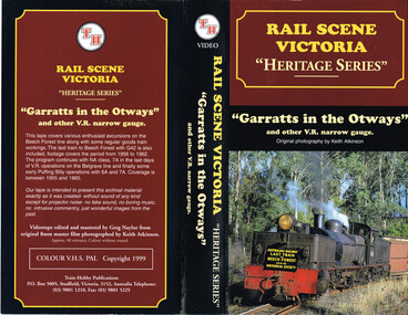 Otway Districts Historical Society
VHS Video, Train Hobby Publications, Garrats in the Otways, 1999
Video covers excursions on the Beech Forest Line. It covers the period 1956 to 1962.Film showing the Beechy Line and activitiesVideo covers excursions on the Beech Forest Line. It covers the period 1956 to 1962.railway narrow gauge -
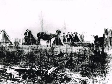 Otway Districts Historical Society
Photograph, Railway survey camp, c.1901
Six surveyors and a horse posing outside five tents somewhere on the Beech Forest line in approximately 1901.Photograph, B/W. Railway survey camp, Beech Forest line.survey camp; beech forest; railways; -
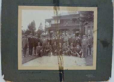
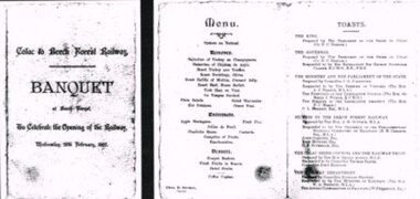 Otway Districts Historical Society
Photograph, Banquet, Opening of Colac-Beech Forest Railway, 1902, 26 Feb 1902
The official opening of the Colac-Beech Forest railway took place on Wednesday, 26th February, 1902. On a typical Beech Forest wet day the train halted at the bottom of Gardner Hill for the opening party led by the State Governor, Sir George Sydenham Clarke, to walk up to the Ditchley Park Hotel for the official banquet in the adjoining hall. The menu of four courses plus coffee was assembed by the caterer, Chas. D. Straker. The toast list was led as usual by a toast to the King, followed by 18 toasts concluded by the Acting Commissioner of Railways.B/W. The menu and toast list at the opening of the Colac-Beech Forest Railway on Wednesday, 26th February, 1902, at Beech Forest. 128mm x 264mm actual -
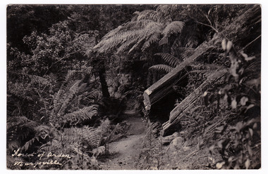 Marysville & District Historical Society
Postcard (item) - Black and white postcard, Forest of Arden Marysville, Unknown
Postcard of early photograph of the Forest of Arden near Marysville.Postcard of early photograph of the Forest of Arden near Marysville.POST CARD PLACE/ POSTAGE/ STAMP/ HEREforest of arden, marysville, forest, tree fern, postcard, souvenir, victoria -
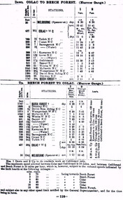 Otway Districts Historical Society
Photograph, Colac-Beech Forest timetable, May 1911
Leaving Colac the narrow gauge train goes through Tulloh. Coram, Barongarook, Kawarren, Lovat, Gellibrand, Banool, Wimba, McDevitt, Weeaproinah, Devitt Bros., and Ditchley before it reaches Beech Forest, and vice versa. The distance in miles, the height above sea level and the timing from the starting point is given. Note that Weeaproinah W NC changed its name to Dinmont when the Crowes line extension is built. Colac-Beech Forest timetable for May, 1911 showing the DOWN train from Colac to Beech Forest, and the UP train from Beech Forest to Colac plus annotations.colac; melbourne; tulloh; coram; barongarook; kawarren; lovat; gellibrand; banool; wimba; mcdevitt; weeaproinah; devitt bros.; ditchley; beech forest; railway; timetable; -
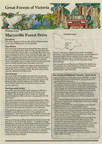 Marysville & District Historical Society
Flyer (item) - Information Flyer, Conservation & Environment, Great Forests of Victoria-Marysville Forest Drive, Pre 2009
A flyer with information on the Marysville Forest Drive in Victoria and the sights and attractions to be found along the drive.A flyer with information on the Marysville Forest Drive in Victoria and the sights and attractions to be found along the drive.marysville forest drive, conservation and environment, victoria, forest, state forest -
Stawell Historical Society Inc
Map, P Jones, Shire of Stawell Roads and Reserves, 1989
Shows Woodlands Forests & Open WoodlandTwo Copies (2) map With roads around Stawell. Forests Woodlands 2 Very open Woodlands Coloured.Drawn P Jones. May 1989. Last Amended 25 may 1989 -
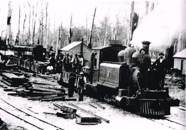 Otway Districts Historical Society
Photograph, Brucker, Beech Forest Station, c1902, c.1902
Gangers on an 5A-class 2-6-2T steam locomotive with goods wagons, and as well as men standing beside the train, at Beech Forest station during construction, c.1902.Beech Forest station during construction of the line, c.1902. gangers; na-class locomotive; beech forest; -
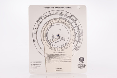 Forests Commission Retired Personnel Association (FCRPA)
McArthur Forest Fire Danger Meter - Mk 5, 1992
The Forest Fire Danger Index (FFDI) was originally invented by the grandfather of Australian bushfire science, Alan Grant McArthur, during the 1950s and ‘60s. Alan published his landmark paper, “Controlled burning in eucalypt forests” in 1962. Leaflet No. 80, as it was known, proved a turning point for forest and fire managers across Australia. More importantly, Alan was very practical forester and wanted his work to be useful to people in the field, so after several iterations he came up with the now familiar circular slide rule called the Forest Fire Danger Meter (FFDM). The Mk 4 version first appeared in operational use in 1967. This is the Mark 5 from 1992Alan McAthur's scientific legacy with the FFDI meter is unquestionably huge and has served forest firefighters very well over the decades.Control burning meter Series of circular slide rules to calculate Forest Fire Danger Index (FFDI)bushfire -
 Whitehorse Historical Society Inc.
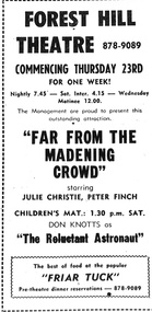
Poster - Forest Hill Theatre, No date
A laminated black and White poster advertising "Far from the Madening Crowd" at the Forest Hill Theatre. No dateA black and white poster advertising "Far from the Madening Crowd" at the Forest Hill Theatreforest hill theatre, films -
 Whitehorse Historical Society Inc.
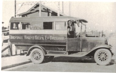
Photograph - Black and white photograph, Nunawading Bus Service
The first bus started running 3rd January 1924 from Tunstall Station to Forest Hill to Burwood.The first bus from Tunstall to Forest Hill to Burwood started 3rd January 1925.tunstall, forest hill, bus, transport -
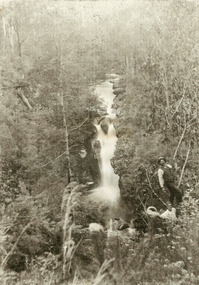
 Marysville & District Historical Society
Photograph (Item) - Black and white photograph, Way to Cumberland Falls, c1900
An early black and white photograph of the forest near the Cumberland Falls in Victoria.An early black and white photograph of the forest near the Cumberland Falls in Victoria. The falls are located on the Marysville-Wood's Point Road. Cambarville is notable for its giant mountain ash (Eucalyptus regnans) trees within the Cumberland Memorial Scenic Reserve, and relics from former sawmills and gold mining. The Big Culvert is located nearby on the Marysville - Woods Point Road, which was historically part of the Yarra Track. Cambarville was established as a timber mill town in the 1940s. Timber mill owners A Cameron and FJ Barton named Cambarville. They established the mill to salvage timber from trees destroyed in the 1939 bushfires. Cambarville was impacted by the 2009 Black Saturday bushfires and any remaining structures were destroyed.ARMSTRONG COLLECTION 42 STATION STREET/ SANDRINGHAM 3191/ TEL. (03) 9521 5442/ IAN M.L. ARMSTRONG OAMcumberland falls, cambarville, marysville, victoria, waterfalls, postcard, souvenir, mountain ash, mining, timber mills, big culvert, yarra track, a cameron, fj barton, black saturday bushfires, 1939 bushfires, eucalyptus regnans -
Whitehorse Historical Society Inc.
Document, Noel Spurr, 2008
Extracts from 'Spurr of the moment'.Extracts from 'Spurr of th moment'. Recollections of childhood of Noel Spurr, who grew up in Forest HillExtracts from 'Spurr of the moment'. mayors, spurr, noel -
 Otway Districts Historical Society
Photograph, Langford, Weston, Goods train arriving at Beech Forest, 1961, 9 August 1961
From late in 1960 VR took what were the first definite steps to close the Colac-Beech Forest line. 1,101 tonnes of freight per year flowed from Colac to Beech Forest because of increasing competition from the roads. From 1 July 1960 onwards, when pulpwood (hardwood) stopped being shipped from Beech Forest, a maximum of only 7,000 tonnes/year would be shipped to Colac. Including special trips passenger revenue earned a little more than $200 per annum. The issue of second-hand sleepers stopped entirely and the two track gangs only patrolled the track and tightened loose bolts. The line did not earn its way and on 4 November 1960 it was recommended that services over the narrow gauge line be discontinued.The rear of a goods train from Colac arrives at Beech Forest on 9 August 1961. The other line is the former Crowes line truncated at Weeaproinah in January 1955. In the background is the Beech Forest Hall and Shire of Otway offices. Colour.colac; beech forest; railway; -
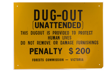 Forests Commission Retired Personnel Association (FCRPA)
Dugout sign, Post 1966
Considered in terms of both loss of property and loss of life, the Black Friday bushfires on 13 January 1939 were one of the worst disasters to have occurred in Australia and certainly the worst bushfire up to that time. The fires burnt 2 million hectares, 69 sawmills were destroyed, 71 people died, and several towns and sawmills were entirely obliterated. Among those killed were four men from the Commission The subsequent Royal Commission conducted by Judge Leonard Stretton has been described as one of the most significant inquiries in the history of Victorian public administration. Its recommendations led to sweeping changes. In addition to building dams and water points, the Stretton Royal Commission recommended expanding and controlling the use of bushfire dugouts at forest sawmills. Well-constructed dugouts had saved the lives of many sawmill workers and their families during the 1939 bushfires. But in some locations, they had proved fatal. Dugouts became mandatory for those few sawmills that remained in the forest after the 1939 fires. Many remote logging coupes and FCV roading camps also had dugouts. The local District Forester was required to make annual pre-season inspections of all dugouts on State forests and those within the Fire Protected Area (FPA). Some were built privately on private land. Most were primitive construction with a log or corrugated iron roof covered with earth. A hessian bag often hung at the entrance to keep the heat and smoke out. But they were dark and damp with snakes and other creepy crawlies often lurking inside. By 1940-41 there were 19 new dugouts constructed by the Commission and a further 128 by forest licensees. Ten years later there were 8 new Commission dugouts and 21 new ones built by other interests. By 1960-61 the rate of new builds was declining but the Commission still managed 103 dugouts while 127 were looked after by others. However, as the forest road network improved and gave all-weather access to modern two-wheel-drive vehicles the reliance on dugouts receded.Large metal sign that was positioned near forest dugoutsbushfire -
Whitehorse Historical Society Inc.
Article, Honor for Commissioner, 19/06/1991 12:00:00 AM
Article by Noeline Egan on David Wynne Jones.Article by Noeline Egan on David Wynne Jones, Forest Hill resident and recipient of an Order of Australia for Scout Association activities.Article by Noeline Egan on David Wynne Jones.jones, david wynne, scout groups -
 Bendigo Historical Society Inc.
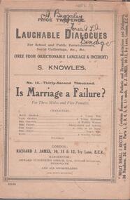
Booklet - Comic play, S. Knowles
Booklet owned by Arthur Baggaley, Fruiterer, who lived at 15 Forest Street, Bendigo. His business 'C.A. Baggaley & Son' was at Covent Garden, Mitchell Street, Bendigo. Arthur was born in Bendigo in 1903 to Charles Arthur Baggaley and Ada (Mallon). He married Evelyn May Grigg. Arthur died in September, 1993.Six page booklet, on front cover: Laughable Dialogues for School and Public Entertainments, Social Gatherings, &c, &c, (free from objectionable language and incident) by S. Knowles, No. 13 "Is Marriage a Failure?'.Baggaley CollectionOn front cover overwritten on text "A. Baggaley, Forest Street, Bendigo'.fruiterer, confectioner, business, mitchell street, covent garden, entertainment, play script, marriage -
 Otway Districts Historical Society
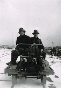
Photograph, Woosnan, Frank, Track gang at Beech Forest, c.1940
At its peak the Colac-Beech Forest-Crowes railway employed more than 21 staff tending the lines that the trains ran over. Gangers (the men in charge of the track gangs) tended to be promoted into the Otways but many of their subordinate repairers were local recruits. A few of the men who worked on the original construction gangs of 1900-02 remained and obtained positions in the track gangs along the line, but these eased out over time. The track was maintained by seven three-man gangs based at Colac, Barongarook, Gellibrand, Banool, Beech Forest (where the second Beech Forest crew was based at Wyelangta), and Lavers Hill.Track gang on an NK wagon at Beech Forest, c.1940. Snow covers the ground. B/W.colac; beech forest; crowes; railway; track gangs; -
Otway Districts Historical Society
Certificate, Australian Natives Association, Certificate of Membership, 1906, November 1906
At the beginning of February 1903 a few men covered the district to see whether the time was ripe to form a Beech Forest branch of the Australian Natives Association. They were surprised at the response from intending members so they contacted the Colac branch who sent up some members as a follow-up. 51 said they would become benefit members and 5 would become honorary members. As a result on the 26 February 1903 a branch of the Australian Natives Association was established in Beech Forest. At a meeting where 40 people were present, Mr. T.M. Burke, the Victorian President, spoke to the meeting, outlining the aims, objects and benefits of the ANA and saying that the Victorian membership was 22,000. He then installed the several officers of the newly constituted Beech Forest branch. By August 1906 the Beech Forest branch membership was moving ahead with sixteen new members being proposed. Mr Fred Cookson was one of them, and he and the other new members were given their Certificates of Membership on the 14 November, 1906.Australian Natives Association, Certificate of Membership, certifying that Mr Fred Cookson of Beech Forest was elected a member of the Beech Forest Branch No.211 on the 14th day of November 1906. Signed by Arthur D. Freeman, President of the Association, and F.C. Wainwright, General Secretary.australian natives association; ana; beech forest; -
Otway Districts Historical Society
Cuttings, Beech Forest Line, 1962
The 55 km narrow-gauge railway line ran for 60 years from 1902 from Colac in south-western Victoria into Beech Forest in the Otway Ranges. Newspaper cuttings from March to June, 1962, from The Age, Sun, Herald and Colac Herald outlining the closure have been collected by Frank McCabe from Lake Boga, Victoria.Beech Forest Line. Various cuttings, 1962.colac; beech forest; railways; frank mccabe; -
Whitehorse Historical Society Inc.
Article, Have your say in Strathdon House, 2015
Whitehorse Council is inviting community feedback.Whitehorse Council is inviting community feedback on the draft report for conservation of the Strathdon Homestead and orchard in Springvale Road, Forest Hill.Whitehorse Council is inviting community feedback. strathdon homestead, springvale road, forest hill, city of whitehorse -
 Otway Districts Historical Society
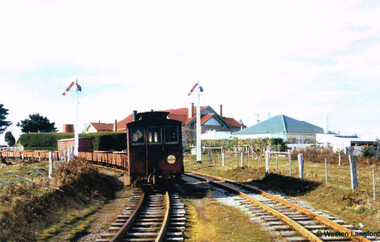
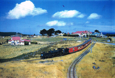
Photograph, Phil A'Vard, Beechy: "Kanyana Special" departing, 1 March 1959
Several "Kanyana Special"s ran from Beech Forest to Colac in the late 1950s to the early 1960s. This photograph of the locomotive G41 and carriages was taken in Beech Forest on 1 March 1959. In the background the Anglicn Church and the Otway Shire Hall and residence are shown.Beech Forest. "Kanyana Special" departing. 1 March 1959. Anglican Church and house, Otway Shire Hall and residence in background. Colour.colac; beech forest; "kanyana special"; anglican church; otway shire hall; locomotive g41; -
 Marysville & District Historical Society
Photograph (item) - Black and white photograph, 1900's
An early black and white photograph of two men in the forest alongside the top level of Steavenson Falls in Marysville in Victoria.An early black and white photograph of two men in the forest alongside the top level of Steavenson Falls in Marysville in Victoria. The Steavenson Falls is named after the Victorian Assistant Commissioner of Roads and Bridges, John Steavenson who arrived in Victoria in the early 1860s.steavenson falls, marysville, victoria, waterfalls, john steavenson -
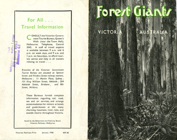 Marysville & District Historical Society
Ephemera (Item) - Information brochure, Victorian Government Tourist Bureau, Forest Giants Victoria Australia, 01-1938
An information brochure on where to see tall trees, Forest Giants, in Victoria, including Marysville, that was published in January, 1938.An information brochure on where to see tall trees, Forest Giants, in Victoria, including Marysville, that was published in January, 1938.Victorian Railways Print January, 1938 469-38 Stamp of Victorian/ Government Tourist Bureau/ 272 Collins Street/ Melbourne C.1victoria, australia, victorian government tourist bureau, betterment and publicity board, victorian railways, white mountain ash, red mountain ash, messmate, blue gum, mountain ash, cumberland valley, marysville, mount monda, healesville, acheron way, alpine highway, omeo, baw baws, strzelecki ranges, otway ranges, warburton, yarra junction, noojee, bulga and tarra valley park, yarram, turton's pass, otway forest, beech forest, apollo bay, information brochure, brochure -
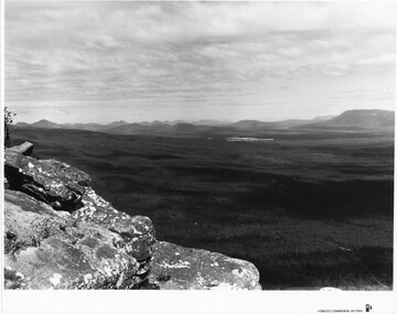 Halls Gap & Grampians Historical Society
Photograph - B/W
Photo is of Moora Moora in the Victorian Valley. Typical of the time as a promotional image taken by Forests Commission Victoria.View over a large Valley with ranges in the distance. Roads through the valley are visible and a body of water in the middle right of the photograph. A rocky outcrop is in the left side foreground.Publicity & Public Relations Branch. When reproducing please acknowledge Forests Commission Victoria Negative no. 322-26scenery, grampians ranges