Showing 176 items
matching victoria hill map
-
 Federation University Historical Collection
Book, The Old Pioneers' Memorial History of Melbourne From the Discovery of Port Phillip to the World War, 1924
Blue hard covered book of 494 pages. Images, and a large plan of prominent burials in the Melbourne Old Cemetery, and a Map of Melbourne. melbourne, melbourne cemetery, melbourne old cemetery, john batman, edmund hobson, batman's map, st francis' church, james balfour, mrs hornbrook, paddy's market, wilson hall, working men's college, henry kendall, le souef's cottage, world war one, westernport, melbourne cup, hoddle, collingwood, south melbourne, prahran, richmond, kew, brunswick, coburg, preston, hawthorn, camberwell, nunawading, doncaster, st kilda, brighton, sandringham, cheltenham, caulfield, oalkleigh, footscray, sunshine, north melbourne, carlton, ballarat school of art library, ballarat technical art school, book plate, library plate, hume and hovell's overland journey 1824-5, major mtichell's overland journey, australia felix, booplate, aborigine, aboriginal, captain cook, arthur phillip, isaac smith, george bass, matthew flinders, john murray, catain baudain, captain collins, edward henty, portalnd, map od melbourne in 1938, john pascoe fawkner, the "enterprise: and fawkner's first home, old colonists' homes, rushall crescent north fitszroy, richard bourke, the old melbourne post offfice, old governmnt house, toorak, latrobe's house at jolimont, first melbourne land sale, melbourne water supply, peter henry smith, victorian legislative council opening, map of melbourne and collingwood, prince's bridge, crossing the rivers by punt, f.a> rucker, canvas city emerald hill, arrival of the gold escort in melbourne, the yarra, queen's wharf, tall ships, old st james, mary e. budd, st francis church, michael carr, meolbourne city mission, state library of victoria, melbourne public library, bourke street, angus mcmilan, methodist ladies college, ormond college, armistance celebrations, robert russell, mia mia, theatre royal bouke st, melbourne from flaggstaff hill, federal coffee palace collins st, lord melbourne, melbourne mint, old melbourne town hall, robert russell's melbourne and yarra falls, mandevalle hall, point lansdale lighthouse, wilson's promontory, margaret m. ward cole, williamstown, flinders st melbourne, queenscliff battery, broadmeadows soldiers' camp, embarkation of first troops on the 'ceramic', general monsash, ian hamilton, general bridges, victorian war memorial, national war memorial, st kilda pier, first melbourne cup, hoddle's grid, albert park, melbourne mechanic's institute, st kilda toll gate, munted policeman, springthorpe memorial, james bonwick, mornane's paddock, victorian railways melbourne and surburban lines, carlton gardens, thomas napier, wiliam westgarth, george augustus robinson, william lonsdale, elizabeth mary batman, peomena frances darling batman, dig tree, exhibition of 1854, exhibition of 1866, exhibition buildings, geelong harbour, jubilee lake, port campbell, warrnambool, queenscliff lightboat, batman's first house -
 Federation University Historical Collection
Booklet, Buninyong Heritage Walks and other Interesting Cycle Rides and Scenic Drives, 2008
Blue soft covered book, with maps, plans and photographs relating to Buninyong, Victoria. buninyong, de soza park, buninyong tannery, buninyong railway station, eagle hotel, old buninyong library, hastie's hill, buninyong town hall, hastie's spring, crown hotel, buninyong post office, bowen tree, aborigines, buninyong primary school, buninyong cemetery, gold monument, mount buninyong, lal lal falls -
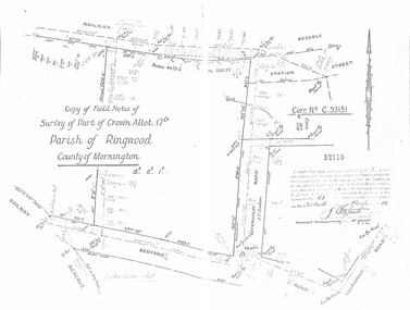 Ringwood and District Historical Society
Document - Copy of Lands Department Field Notes - Parish of Ringwood, Victoria, Field Notes - Part of Crown Allotment 17D Surveyed 1952 (Amended in 1953)
5616b Double foolscap size photocopy of survey map with handwritten notations. References include Corr no. C.93151, Railway Reserve, Station Street, Bedford Road, multiple post & wire fences, multiple galv iron pipes put in, Government Road (Hill Street), Tooronga Road, multiple recent pegs found, Certification 52710 by J. Fitzgerald Licensed Surveyor 17/3/1952. -
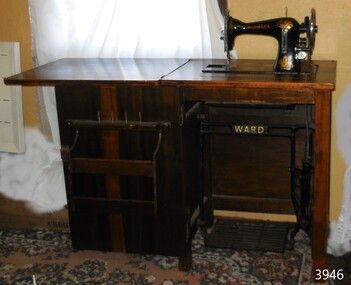 Flagstaff Hill Maritime Museum and Village
Domestic object - Sewing machine in cabinet, Ward Brothers (G & S Ward), ca. 1933
The donor inherited this Wardana machine from her mother, who bought it in about 1933 and used it to sew garments for her sister's dressmaking business in Frankston, Victoria. The donor often used this machine until she purchased an updated model. There were originally three Ward Brothers who owned the North Melbourne sewing machine business but they had a falling out. This machine's decals on the map of Australia only include the two remaining brothers. The Ward Brothers, G & S Ward, established their sewing machine business in North Melbourne in 1888. The cabinets and ironwork of the machines were made in Australia and the Ward Bros. imported their machines from overseas manufacturers in England, America and Germany. The assembled machines were sold under brand names that included Ward, A.N.A. the patriotic-sounding Australian Sewing Machine Company. The "Wardana" was one of their brands.This sewing machine was fabricated in Australia from imported parts from England, giving a snapshot into the early manufacturing industries that were operating at the time just after Federation.Sewing machine in a wooden cabinet with iron foot-operated cast iron treadle mechanism. The hinged cabinet top opens out to form a worktop. The sewing machine lifts out of the cabinet to sit level with the worktop, resting on two supports within the cabinet. The lockable cabinet door opens from right to left revealing fitted shelves and spikes for spools and bobbins. The gold-painted maker's name is cast into the black treadle. The machine has its original instruction book, oil can, and eighteen accessories in an enclosed cardboard box. The round shallow oil bottle has a rubber dispensing tube. Colourful decals decorate the black body of the machine. Inscriptions include a Serial Number stamped on the bed of the machine. The Wardarna Central Bobbin machine was made in England for the Ward Brothers of North Melbourne.TREADLE: cast into metal ACROSS THE TOPE AND ON THE FOOTPLATE "WARD", "WARD" SERIAL NUMBER stamped into oval plate "28383" DECAL: (Map of Australia ) with images of [two brothers] , "WARDANA" above (logo of the rising sun) DECAL: (Decorative floral design with heraldic-like emblems) above "MADE IN ENGLAND" ARM: "WARDANA" PEDESTAL: "C.B." (representing Central Bobbin) "MADE IN ENGLAND" "MADE IN ENGLAND / FOR / WARD BROS / NORTH MELBOURNE" BOOK TITLE: "Instructions for Treadle Machine" ACCESSORIES: some have indecipherable embossed stamps OIL BOTTLE base: (image of log and short lines radiating from a central inscription (indecipherable)sewing machine, domestic, wardana, ward bros., central bobbin, made in england, north melbourne, c.b., flagstaff hill, warrnambool, shipwrecked coast, flagstaff hill maritime museum, maritime museum, shipwreck coast, flagstaff hill maritime village, great ocean road, treadle sewing machine, home industry, clothing, dressmaking, clothing manufacturer -
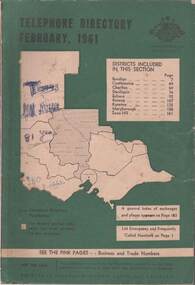 Bendigo Historical Society Inc.
Book - TELEPHONE DIRECTORY FEBRUARY 1961, February 1961
Soft covered Telephone Directory February 1961. Districts covered are Bendigo, Castlemaine, Charlton, Deniliquin, Echuca, Kerang, Kyneton, Maryborough, Swan Hill. Cover has a green background with an outline of the map of Victoria in white. The Victorian Telephone directory boundaries are indicated and the district covered is shaded with black dots. Some handwritten jottings are written in ink on the cover. The directory contains both white and pink pages.book, bendigo, bendigo history & its people -
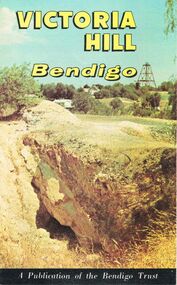 Bendigo Historical Society Inc.
Document - JOAN O'SHEA COLLECTION: VICTORIA HILL GOLDMINING AREA BOOKLET, March 1972
... Joan O'Shea Collection. Victoria Hill Bendigo Gold Mining... Pages. Includes Maps of the Victoria Hill Area, photographs ...Joan O'Shea Collection. Victoria Hill Bendigo Gold Mining on the Richest Quartz Reef in Bendigo, from 1854 to 1916. Colour and Black and White Booklet 16 Pages. Includes Maps of the Victoria Hill Area, photographs of the remains of a twenty head crushing battery, burnt ground from quartz roasting, The Victoria Quartz Mine Photograph from Australian Mining Standard June 1899, The compressor beds and concrete foundations for the poppet legs all that remain today of the Victoria Quartz Mine deepest mine on Bendigo Goldfield 4613 feet or 1406.04 metres. Also included photograph of the view of Victoria Hill from The New Chum Hill in the 1870s. The Location of the 3 mines Ballerstedt's open cut, North Old Chum and Lansell's 180 are marked. A depiction of Rae's Open Cut gives an understanding of the primitive nature of early workings on the Goldfields. The Booklet also provides a brief history of Victoria Hill itself.Bendigo Trust Publication March 1972. Printed in Bendigo Cambridge Press.bendigo, mining, victoria hill -
Bendigo Historical Society Inc.
Map - NERRING : COUNTY OF BENDIGO, August 1952
Map. Nerring, County of Bendigo, Yarraberb, Leichardt, Marong, Sandhurst, Huntly, Neilborough, Bendigo and Swan Hill Railway, Bendigo and Kulwin Railway, Loddon Valley Highway. By authority J.J. Gourley, Government Printer, Melbourne. Drawn and reproduced at the Department of Lands and Survey, Melbourne, Victoria. August 1952. Price $1.00. (number 76 in map cupboard 1)J.J. Gourley, Government Printer, Melbourne.map, bendigo, nerring -
 Bendigo Historical Society Inc.
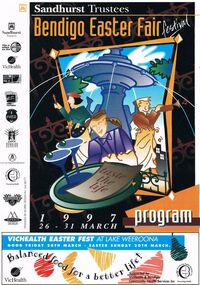
Document - BENDIGO EASTER FAIR FESTIVAL PROGRAM 1997, 26 March 1997
Bendigo Easter Fair Festival Program, 26-31 March, 1997. Festival Features, Evening of Art & Classical Music, Rotary Club of Bendigo. VicHealth Easter Fest, Victorian Health Promotion Foundation & Bendigo Community Health Services. Fine Food Fest. Free Stage. Free Evening Concert & Fireworks, Zaire. Torchlight Procession, sponsored by Prime TV & Coca Cola, Bendigo Market Place. Fireworks Spectacular, Sponsored by Bendigo Market Place & Prime TV. Street Fiesta, sponsored by Arts Victoria. Street Extravaganza, Coca Cola Carnival, Sponsored by Coca Cola. Star for a Day, Power Audio Visual & Prime Television. Handcraft Bazaar, Rotary Club of Bendigo Sandhurst Art & Craft Market. Cosmopolitan Street Café, Arts Victoria. Awakening of the Dragon, Bendigo Chinese Association. Gala Parade, Prime Television & Coca Cola. Firewalking by the Australian Skeptics, Discovery Science & Technology Centre. Up In Flames, Discovery Science & Technology Centre. Barry Kenny's Country Roundup, Nadort Promotions. School's Day. Teddy Bear's Picnic, Dragon City Marshals. Fire Brigades Children's Carnival. Family Event, Bendigo Minister's Fellowship. Bendigo Easter Antique Fair. Historic Photographic Exhibition, Burt Sargent Circa 1900. Open Garden at Nanga Gnulle (''nanga nully''). A parade of Quilts, Strathdale Bendigo Quilters Inc. Tasting the Life, Gail Tavener Studio. Snakes Alive Dangerous Australians, BRIT. Y's Men's Club of Bendigo Book Fair, YMCA. Bendigo Camera Club, BRIT. Bendigo Woodcraft Exhibition, Woodturners Bendigo Inc. Autumn Bonsai, Bendigo Bonsai Club. Convocation, National Trust Bendigo. Arms & Collectables, Golden City Collectors Assoc. In. Rotary Art Show. Rotary Pottery Exhibition. Women's Vision For The Church, Provincial Council of Mothers Union. Historic Toorak House, Lioness Club of Golden City Bendigo. White Hills Cemetery. Bendigo Cemetery. Festival of Flowers, Craft & Garden, Bendigo Jockey Club. Shannons Corporation Motorfest, City Drive Through, Static Display, Motorkhana, Time Trial. Bendigo Bank Dragon Mile. Volkswagen Car Show, a part of the 28th National Bug-In. Repco Cycles, Australian Veteran Cycling Council Inc. Championships. Under 17 Australian Badminton Championships. Palm Sunday, Bendigo Symphony Orchestra. Way of the Cross, Bendigo's Combined Churches. The Easter Story, Kangfluca Music. Sunrise Church Service, Bendigo Ministers' Fellowship. Map of CBD Advertisements: Bendigo Easter Antique Fair. Austar. Bendigo Art Gallery. Bendigo Visitor Information Centre. Prime. Golden Dragon Museum Inc. Bendigo Heritage Tours. Discovery Science & Technology Centre Bendigo. Sponsors: Sandhurst Trustees, Prime, Vic Health, ABC Radio, Arts Victoria, Coca Cola, Events Bendigo, City Of Greater Bendigo, Bendigo Community Health Services, Shannons., Morris Design PH 5448 8777Morris Designevent, easter fair, bendigo easter fair, bendigo easter fair festival program, 26-31 march, 1997. festival features, evening of art & classical music, easter fest, . fine food fest. free stage. free evening concert & fireworks. torchlight procession. fireworks spectacular, street fiesta, street extravaganza, coca cola carnival, star for a day, handcraft bazaar, art & craft market. cosmopolitan street café, awakening of the dragon. gala parade, firewalking australian skeptics, discovery science & technology centre. up in flames, barry kenny's country roundup, nadort promotions. school's day. teddy bear's picnic, fire brigades children's carnival. family event, bendigo minister's fellowship. antique fair. photographic exhibition, burt sargent circa 1900. open garden nanga gnulle a parade of quilts, strathdale bendigo quilters inc. tasting the life, gail tavener studio. snakes alive dangerous australians, brit. book fair, ymca. bendigo camera club, brit. bendigo woodcraft exhibition, woodturners bendigo inc. autumn bonsai, bendigo bonsai club. convocation, national trust bendigo. arms & collectables, golden city collectors assoc. art show. pottery exhibition. women's vision for the church, provincial council of mothers union. historic toorak house, lioness club. white hills cemetery. bendigo cemetery. festival of flowers, craft & garden, bendigo jockey club. motorfest, drive through, static display, motorkhana, time trial. dragon mile. volkswagen car show, national bug-in. repco cycles, australian veteran cycling council inc. championships. under 17 australian badminton championships. palm sunday, bendigo symphony orchestra. way of the cross, bendigo's combined churches. the easter story, kangfluca music. sunrise church service, bendigo ministers' fellowship. map of cbd advertisements: antique fair. golden dragon museum inc. bendigo heritage tours. discovery science & technology centre bendigo. sponsors: sandhurst trustees, vic health, abc radio, arts victoria, coca cola, events bendigo, city of greater bendigo, bendigo community health services, shannons., morris design. prime tv. austar. bendigo art gallery. bendigo visitor information centre. prime, victorian health promotion foundation, zaire, sponsored by bendigo market place & prime tv, sponsored by arts victoria, sponsored coca cola, power audio visual, rotary club of bendigo sandhurst, bendigo chinese association, y's men's club of bendigo -
 Bendigo Historical Society Inc.
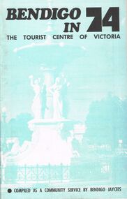
Book - BOOKLET: BENDIGO IN 74
48 paged booklet - ''Bendigo in 74 - The Tourist Centre of Victoria'' - compiled as a community service by Bendigo Jaycees. Comprehensive information about Bendigo and attractions - Index: Accommodation; Additional information; An introduction to Bendigo; Aquarium; Art Gallery; Bendigo Trust; Caravan parks; Dai Gum San; Directory; Eaglehawk Museum; Entertainment; Emergency services; Joss House; Lake Eppalock; National Trust classified buildings; Natural history; Map of Bendigo; Map of city centre; Pottery; Picnic areas; sporting facilities; 'Talking Trams'; Thanks; Tours; Tourist attractions; Victoria Hill; What's on in Bendigo.Bendigo Jaycees. Espress Printers Bendigo.bendigo, tourism, guide 1974, bendigo jaycees, radio 3bo, city family hotel, don murray's hotel motel, cambrian hotel, charlies craft & lifestyle store, powneys authorised newsagent, the bendigo trust, white hills panel works, bendigo pottery, bendigo racecourse, homestead motor inn, peter wade, the persian room, sandhurst trading co. pty. ltd., bendigo air services, bendigo sec, geo. r. innes & sons, cohns, the copper pot, sandhurst travel service. golden hills motel, welcome stranger motel, brian boru hotel, john lindsay's pharmacy & photographic centre, alf morris motors -
 Bendigo Historical Society Inc.
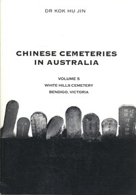
Book - CHINESE CEMETERIES IN AUSTRALIA VOLUME 5, c
Chinese Cemeteries in Australia Volume 5, White Hills Cemetery Bendigo, Victoria. Publisher: Golden Dragon Museum, Bendigo. ISBN: 09578013 7 8. 191 PAGES. Black and white illustrations & maps. Published post 12 July 2003. Inscriptions $30.Dr Kok Hu Jinaustralia, history, chinese, white hills cemetery, chinese graves, genealogy -
 Bendigo Historical Society Inc.
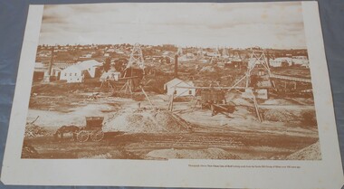
Photograph - Photograph of New Chum Line of Reef
BHS CollectionSepia coloured print of a photograph of the New Chum Line of Reef looking south from the Snobs Hill group of mines. The photo shows several poppet heads and chimneys, bridges and houses. New Chum Line of Reef. includes Victoria Hill possibly the richest spot on the field.On the back a drawing of a poppet head with the words: Bendigo gold project. A small map of Victoria is also printed on the back. bendigo mines, new chum line of reef, mining -
Bendigo Historical Society Inc.
Map - MINE LOCATION DRAWING AT VICTORIA HILL
Claims and shafts location for: Rae and co. - Noye and co. - Wittscheibe. Some additions to drawing made in pencil.mining, business -
 Bendigo Historical Society Inc.
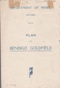
Map - BENDIGO GOLDFIELDS MAP
Map of the Bendigo Goldfield, showing reef lines, mines and significant geographical features such as Monument Hill, Quartz Hill and Diamond Hill. On the back of map 'Department of Mines, Victoria. Plan of Bendigo Goldfield.bendigo, mining, bendigo goldfields -
Bendigo Historical Society Inc.
Document - DIAMOND HILL HISTORIC AREA PARKS VICTORIA
Document, two pages, prepared by Parks Victoria in relation to the Diamond Hill Historic Area. Contains information regarding the history of the area; German Miners; Plants and animals. On second page is a map of the area showing historic features: Deborah Consolidated Gold workings Red, White and Blue Extended gold workings Goldfields Extended gold workings Dead Dog Gully, alluvial gold workings Glasgow & Golconda Gold workings and tramway Surface gold mining site Hansel Mundy gold workings Bendigo Goldfields Pty gold workings Stafford gold workings Langdon gold workings Great Opossum Gully alluvial gold workingsbendigo, mining, diamond hill -
Bendigo Historical Society Inc.
Map - HUSTLER'S & CHRISTMAS LINES OF REEFS - PLAN OF LINES OF SECTION OF REEFS
Underground Survey of Mines Bendigo. Plan of Cross Section Lines Shewing Connections with Trigonometrical Stations and Base Lines. 13/3/99 Signed ? Stirling. Places and mines mentioned Speciman Hill, Tambour Major, Lansell's 180, Victory and Pandora, Great Extended Hustler's, Windmill Hill on Victoria Reef. Next part of map is a Plan of Lines of Section between the Hustler's and Christmas Lines of Reefs. 8/3/99. Signed ?. Transverse Section. Shows Tambour Major Co., near the Christmas Line of Reef, Crosscuts and their depth, geological features and stone encountered. Then shows Thistle Line, Charshalton Line, Napoleon Line, Nell Gwynne Line, New Chum Line, Lansell's No 180 with levels, depths and geological features. Drawing is continued in three parts to fit on paper. Lansell's East Shaft with levels and depths, geological features and stone encountered. Sheepshead Line, Old Shaft, Garden Gully Line, Victory and Pabndora Co with crosscuts, depths, geological features and stone encountered. Paddy's Gully Line, Derby Line, Millers Line, Hustler's Line, Great Extended Hustler's Co with levels, depths, geological features and stone encountered. A note beside a Saddle Reef: 360,000 pounds paid in dividends from this reef. Average ounces per ton gold noted where found. Reference Table for stone and geological features. Datum Line 700 feet above Sea Level Unscannedmining, parish map, hustler's & christmas lines of reefs, plan of lines of section of reefs, ? stirling, specimen hill, tambour major, lansell's 180, victory & pandora, great extended hustler's, windmill hill, victoria reef, tambour major co, christmas line, hustler's line, thistle line, carshalton line, napoleon line, nell gwynne line, new chum line, lansell's no 180, lansell's east shaft, sheepshead line, old shaft, garden gully line, paddy's gully line, derby line, miller's line, hustler's line, great extended hustler's co -
Bendigo Historical Society Inc.
Map - CAMPBELL COLLECTION: BENDIGO AND DISTRICT MAPS, 1982
Map. Forest Commission Victoria, Bendigo Forest District, Sub-Plan 1 District Fire Prevention Plan, Greater Bendigo Area. Prevention Strategy Plan. Shire of Marong, Shire of Huntly, Borough of Eaglehawk, Shire of Strathfieldsaye, Sailors Gully, Epsom, Jackass Flat, White Hills, California Gully, Maiden Gully, Long Gully, North Bendigo, City of Bendigo, Bendigo East, Kennington, West Bendigo, Golden Square, Quarry Hill, Flora Hill, Spring Gully, Kangaroo Flat.Base prepared 1982. (number 397 in map cupboard 1)map, bendigo, forest district -
 Bendigo Historical Society Inc.
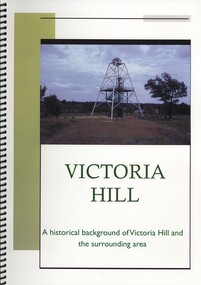
Book - VICTORIA HILL, A HISTORICAL BACKGROUND OF VICTORIA HILL AND THE SURROUNDING AREA, 2011
Victoria Hill a historical background of Victoria Hill and the surrounding area. Original article by Albert Richardson 1971 and revised and edited in 2012 by Philip Wilkin. Contains 26 pages with colour and black & white photographs and a map. Inside front cover is a 'Bendigo Miner' History Lives article by Jim Evans, dated 10 May 2012.Albert Richardson & Phillip Wilkinbendigo, mining, victoria hill -
 Bendigo Historical Society Inc.
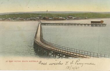
Postcard - GLADYS DEAN COLLECTION: POSTCARD, 1906 - 1908
Coloured photographic postcard of Port Victor South Australia with a 1.5cm white border along the bottom edge. Image is taken from the sea and depicts a long pier curving back to shore with another jetty running off to the right. On the shore many buildings are in the distance against a low green hill. The words At Port Victor, South Australia are printed in red on the left hand side of the border. Handwritten in the border are the words Best wishes T S Perryman 13/4/07 in pencil. On reverse, South Australia Post Card is printed in red with a map of Australia at the top and card is addressed to Miss R Dean Golden Square Victoria. A one penny stamp is affixed postmarked Adelaide.South Australia Post Cardpostcard -
 Bendigo Historical Society Inc.
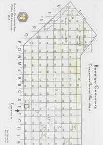
Map - FRIENDS OF WHITE HILLS CEMETERY COLLECTION: TWO MAPS
... by Remembrance Parks Central Victoria. Map FRIENDS OF WHITE HILLS ...Maps. Two maps of Bendigo Cemetery. (a) Bendigo Cemetery produced by Bendigo Cemeteries Trust. (b) Bendigo Remembrance Park produced by Remembrance Parks Central Victoria.map, bendigo, bendigo cemetery and remembrance park -
Bendigo Historical Society Inc.
Map - RAYWOOD GOLD FIELD MAP, 1902
Map. Raywood Gold Field Map. Linen backed map of Raywood and Neilborough Township and surrounds showing the location of varying underground workings. Surveyed by H S Whitelaw 1/6/02. It shows underground workings from The Perseverance Party and moreshed and Party and underground workings on the Old Pioneer Reef. Mentions the Parish of Yallook, Parish of Neilborough, Yarraberb, Mushroom Flat, Murray Valley Plain, Eaglehawk and Kerang Railway, Green Hill, Doughboy, Redmond's Gully, Pickpocket Lead, Raywood Lead, Inglewood Lead, Shaw's Road, Nuggety Shaft, Barkly Shaft, Maori Bendmap, gold field map, raywood gold field map, neilborough, h s whitelaw, geological survey of victoria bulletin no 12 plate 11 -
 Bendigo Historical Society Inc.
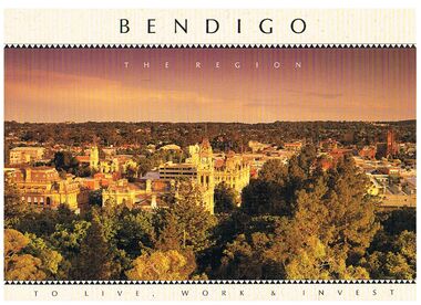
Book - BENDIGO - THE REGION TO LIVE, WORK & INVEST
Pale yellow 12 page book titled 'Bendigo the Region to Live Work & Invest'. On the front cover is a scenic view of Bendigo and on the back cover a picture of some quartz and gold nuggets on a green background. Sections in the book are: Live Work & Invest, Lifestyle, Access, Community, Infrastructure, Labour Force, Business, Opportunity, Successes and Information. Each page has a colour picture, they are:- Hargreaves Mall, Eaglehawk Golf Course, Map of Victoria, La Trobe University, Big Hill, Regional Office Department of Planning & Development, Sandhurst Farms, Construction Activity, Products of the Region, Dr. Ian Macbean, Mr Evan Jones and the Capital Theatre with information on each.book, bendigo, bendigo, bendigo - the region to live, work & invest, bendigo regional development board, dr ian macbean, mr evan jones, kate mildren, richard gibbs, express printers, hargreaves mall, eaglehawk golf course, map of victoria, la trobe university, big hill, regional office department of planning & development, sandhurst farms, construction activity, products of the region, capital theatre -
 Bendigo Historical Society Inc.
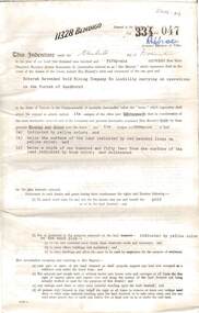
Document - MCCOLL, RANKIN AND STANISTREET COLLECTION: BENDIGO EXTENDED GOLD MINING COMPANY N/L MINING LEASE, 13 November 1956
Document: Bendigo Extended Gold Mining Company gold mining lease. 4 page document with attached map. Map shows area running roughly parallel to Adam Street, Quarry Hill. Lease between Bendigo Extended Gild Mining Co. N/L and State of Victoria. No. 11328, Vol 334 Fol 047.organization, mining, gold mining lease, bendigo extended gold mining co n/l; gold mining lease -
 Bendigo Historical Society Inc.
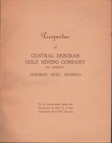
Document - MCCOLL, RANKIN AND STANISTREET COLLECTION: CENTRAL DEBORAH GOLD MINE NL: PROSPECTUS, 1939
Document: McColl, Rankin & Stanistreet Collection: Central Deborah Gold Mine NL - 4 copies of prospectus. Buff covered booklet. Written on front ' Prospectus of Central Deborah Gold Mining Company No Liability Deborah Reef, Bendigo. To be incorporated under the Provisions of Part II of the companies Act 1938. Victoria.' Details capital, proposed directors and manager. Contains map of Central and North Deborah mines and Monument Hill.organization, business, central deborah gold mine, mccoll, rankin & stanistreet collection: central deborah gold mine nl. gold mining -
Bendigo Historical Society Inc.
Map - BIG 180 SHAFT POSITION, No date visible
... Bendigo mining plan Mining Gold Mines. Victoria Hill Big 180 Map ...Map: Plan showing the location of various shafts in the Victoria Hill area, hand draughted in pencil. Scale 2 Chains to 1 inchmap, bendigo, mining plan, mining , gold mines. victoria hill, big 180 -
 Victorian Aboriginal Corporation for Languages
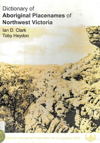
Book, Ian D Clark et al, Dictionary of Aboriginal placenames of Northwest Victoria, 2002
Dictionary including Indigenous and European place names. Origins are given.maps, b&w photographsgrampians, hindmarsh, horsham, ararat, gannawarra, mildura, swan hill, glenelg, djabwurrung, djadjawurrung, jardwadjali, dadidadi, wergaia, wembawemba, barababaraba, wadi wadi, wathawurrung, ladji ladji -
 Victorian Aboriginal Corporation for Languages
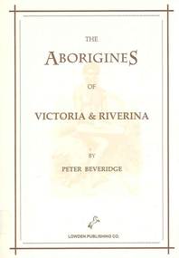
Book, Peter Beveridge et al, The Aborigines of Victoria and Riverina, 2008
The Beveridges pioneered the Swan Hill area on the Murray River and lived among the People of the Murray River. They learned the Aboriginal dialects, lore and customs. Peter Beveridge faithfully recorded these and his book was published posthumously by his family.maps, b&w illustrations, b&w photographsvictorian history, murray river -
 Nillumbik Historical Society Incorporated
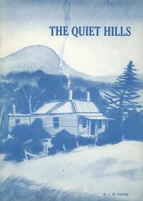
Book - Softcover book, Doreen Primary School, The Quiet Hills, 1983
A history in recollections and photographs of the Doreen district of Victoria, AustraliaCover is card 300gsm with painting converted to blue tones on front and back with white semi gloss paper pages 100gsm - 37 pages plus 3 page index and maps on inside of front and back coversnon-fictionA history in recollections and photographs of the Doreen district of Victoria, Australia -
Whitehorse Historical Society Inc.
Map, Aerial photographs Nunawading, 1972
Department of Crown Lands and Survey, Melbourne, 1972.Department of Crown Lands and Survey, Melbourne, 1972. Project runs 34 - 39 - City of Nunawading. frames numbered from South to North boundaries, each strip numbered from West to east. The series extends further West to Box Hill and East to Ringwood than the 1970 project. No index map. Sheets 39/2 and 34/28 missing.non-fictionDepartment of Crown Lands and Survey, Melbourne, 1972.victoria. department of crown lands and survey, aerial photographs, nunawading, mitcham, blackburn, blackburn north, blackburn south, forest hill, vermont, burwood east, box hill, ringwood, vermont south -
Whitehorse Historical Society Inc.
Map, Aerial photographs Nunawading, 1976
Department of Crown Lands and Survey, Melbourne, 1976 Project.Department of Crown Lands and Survey, Melbourne, 1976 Project. Runs 29 - 33 City of Nunawading. Frames numbered from South to North boundaries, each strip numbered from West to East. No index map. Sheets 30/8 and 30/9 missing.non-fictionDepartment of Crown Lands and Survey, Melbourne, 1976 Project. victoria. department of crown lands and survey, aerial photographs, nunawading, mitcham, blackburn, blackburn north, blackburn south, forest hill, vermont, vermont south, burwood east, box hill, ringwood -
Whitehorse Historical Society Inc.
Map, State Savings Bank of Victoria, 1921
... of Victoria Map of Box Hill, Blackburn and Tunstall, 1921 from ...Map of Box Hill, Blackburn and Tunstall, 1921 from Australian Guide and Business Directory showing site of Box Hill branch of State Savings Bank of Victoria.Map of Box Hill, Blackburn and Tunstall, 1921 from Australian Guide and Business Directory showing site of Box Hill branch of State Savings Bank of Victoria.Map of Box Hill, Blackburn and Tunstall, 1921 from Australian Guide and Business Directory showing site of Box Hill branch of State Savings Bank of Victoria.maps, box hill, blackburn, state savings bank of victoria