Showing 190 items
matching victoria reef gold mines
-
 Bendigo Historical Society Inc.
Document - VICTORIA HILL - THE RICH VICTORIA HILL AND IT'S HISTORICAL ASSOCIATIONS
Multiple handwritten and carbon copies refering to Victoria Hill. Mentioned in the notes are places of interest between Ironbark and Victoria Hill areas, history of the area and sign posts for the Victoria Hill area.document, gold, victoria hill, victoria hill, the rich victoria hill and it's historical associations, j n macartney, quartz miners' arms hotel, ironbark methodist church, greek orthodox church, conrad heinz, john brown industries knitwear factory, little 180 mine, george lansell, british & american hotel, victoria reef gold mining coy, manchester arms hotel, housing commission homes, the ironbark (victoria reef gold), hercules & energetic, midway, wittscheibe, gt central victoria, wm rae, mr and mrs conroy, mrs lavery, central nell gwynne, moorhead's shop, gill family, gold mines hotel, david chaplin sterry, new chum and victoria mine, p m g repeater station, old chum mine, pioneer, rotary club of bendigo south, north old chum mine, ballerstedt's first open cut, lansell's big 180 mine -
Bendigo Historical Society Inc.
Document - VICTORIA HILL - THE RICH VICTORIA HILL AND ITS HISTORICAL ASSOCIATIONS
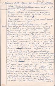
Copy and a photocopy of notes titled 'The rich Victoria Hill and its Historical Associations. The photocopy does not have copies of the photos. Notes include Introduction, directions for getting to Victoria Hill, North Old Chum Mine 2310 ft deep, Ballerstedt's First Open Cut, Geographical Features, Lansell's Big 180, Crushing Battery, Lansell's Cleopatra Needle type chimney, Victoria Quartz Mine 4613 ft deep, Victoria Reef Quartz Company, Victoria Quartz Company, Victoria Quartz Dams, Rae's Open Cut, Quartz Roasting, Floyd's small 5 Head Crushing Battery, Great Central Victoria (Midway) Shaft, Ballerstedt's Small 24 yard Claim, The Humboldt, The Adventure, The Advance and Luffsman and Sterry's Claim. Copies of photos include: Victoria Hill from Rae's Open Cut, Looking North from Old Chum Hill to the Victoria Hill, the Victoria Quartz Mine and Wm. Rae's Crushing Works.document, gold, victoria hill, victoria hill, the rich victoria hill and its historical associations, j n macartney, quartz miners' arms hotel, ironbark methodist church, john brown knitwear factory, little 180, george lansell, conrad heinz, british and american hotel, victoria reef gold mining company, manchester arms hotel, housing commission homes, the ironbark, hercules and energetic, midway, wittscheibe, great central victoria, wm rae, mr & mrs conroy, moorhead's shop, central nell gwynne, gold mines hotel, david chaplin sterry, new chum & victoria, old chum, burrowes & sterry, rotary club of bendigo south, big 180, north old chum mine, ballerstedt's first open-cut, lansell's bit 180 shaft, victoria quartz mine, victoria reef quartz company, a roberts & sons, mr e j dunn, h harkness & sons, new chum drainage scheme, eureka extended, new chum railway, the pearl, inrush of water, shamrock, shenandoah, victoria quartz dams, rae's open cut, floyd's small 5 head crushing battery, great central victoria (midway) shaft, midway no 2, midway north, the humboldt, the adventure, the advance, luffsman & sterry's claim, chinese joss house, fortuna, p m g repeater station, bendigo and vicinity 1895, j n macartney 1st edition 1871, mr rae anderson, 'gill family, annals of bendigo obituary notices 1904, mining records and australian mining standard special edition 1/6/1899, bendigo advertiser 22/6/1871, b m l records mines department, patterson's goldfields of victoria, dickers mining record 23/11/1861, annals of bendigo, bendigo advertiser 24/7/1933, 27/8/1908, 30/6/1910, 16/6/1910, 17/6/1910, mining reports for 1910, australian mining standard special edition 1/6/1899 p40, bendigo mines ltd, mines department records, the bendigo goldfield 1851 to 1954, the victoria hill 1854 to 1949, wm rae's crushing works -
 Bendigo Historical Society Inc.
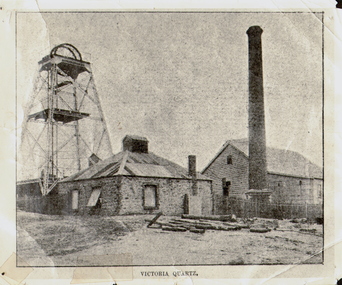
Photograph - VICTORIA QUARTZ - NEW CHUM LINE OF REEF, c.1890
Black and white photograph. Poppet head on LH side, stone building, centre, tall brick chimney, RH side in front of timber building. Inscriptions: on front - 'Victoria Quartz'. On back - typewritten description as follows: 'Situated on the rich Victoria Hill, Ironbark. Steel girders? rams type poppet legs - 60ft high. Vertical winding engines; pair of 24' dia. Winding drums. Made and erected by Roberts & Sons, Bendigo, in 1897. Then one of the best in the state. In 1910 it was the deepest gold mine in the world, having reached a depth of 4,613 ft in the winze. The shaft was then sunk to a depth of 4,588 ft. in an endeavour to reach a depth of 4,870 ft. to effectively work the deepest gold bearing reef in the world. On the night of June 14th, 1910, the mine was flooded out by the rising waters from the deep New Chum mines to the south, all of which had either ceased operations or had returned back to shallow workings. For details of the mine's record, see 'The Historical Guide to Bendigo'. Mine details completed by A Richardson, 29 Harrison Street, Bendigo.place, mining site, victoria quartz -
 Bendigo Historical Society Inc.
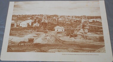
Photograph - Photograph of New Chum Line of Reef
BHS CollectionSepia coloured print of a photograph of the New Chum Line of Reef looking south from the Snobs Hill group of mines. The photo shows several poppet heads and chimneys, bridges and houses. New Chum Line of Reef. includes Victoria Hill possibly the richest spot on the field.On the back a drawing of a poppet head with the words: Bendigo gold project. A small map of Victoria is also printed on the back. bendigo mines, new chum line of reef, mining -
 Bendigo Historical Society Inc.
Photograph - Victoria Hill, Bendigo, 1973
Gold was discovered on Victoria Hill in 1854 and by 1861, 1,200,000 ounces of gold had been extracted from the site. The first claim was bought for 80 pounds by Prussian immigrant Christopher Ballerstedt and his son Theodore. Christopher Ballerstedt was nicknamed the "Father of the Hill" and was the first to prove that gold reefs extended below the surface. His 200-foot plus mine shafts yielded quartz rich with gold, inspired other miners, and were instrumental in Bendigo becoming the world's deepest and richest goldfield. The site still features relics of nineteenth century mining including quartz crushing machinery and the foundations of George Lansell’s 180 mine. These features are characteristic of Bendigo’s mining history and represent two prominent nineteenth century miners, Christopher Ballerstedt and George Lansell, who held important roles in the development of Bendigo. Victoria Hill Quartz Gold Mines are registered as a site of significance. The site is of historical, archaeological and scientific importance to Victoria. The mines represent the symbolic heart of Bendigo’s gold mining history and the importance that mining played in wealth creation and the development of Victoria. The diggings reserve is accessed from the rear of Albert Richardson Reserve located at 40-56 Marong Road, Ironbark. The site has steep and unformed paths and is closed to the public at dusk. It is important to stay to the paths to avoid the diggings. Interpretive signs help visitors to appreciate the importance of the site and the remaining relics of Bendigo’s mining history.Victoria Hill Ironbark, Bendigo. Photos of the poppet head, sand heap, tailings, shafts and tunnels. Before development into a tourist attraction.history, bendigo, victoria hill, ironbark, diggings -
 Bendigo Historical Society Inc.
Book - BENDIGO PHOTO ALBUM
Small booklet, green cover with golden writing. Bendigo in large letters, Victoria Australia square ornate around. Photos inside: Charing Cross and Pall Mall. Conservatory grounds. Post office and Law courts. Botanical gardens, White Hills. The fountain Charing cross, Pall Mall. Chinese procession on Easter Monday. School of mines and industries. A group of Bendigo mines. View Point. Boring on a gold bearing reef. New chum railway gold mine. Queen statue, Rosalind park. Soldiers 'statue near post office. Conservatory, Rosalind park. Gold Jubilee statue, Pall Mall. on the back cover in pen: Miss E. Briggs, Locksly P.O N.E. Lina(?)bendigo, tourism, various photos -
 Bendigo Historical Society Inc.
Document - ALBERT RICHARDSON COLLECITON: VICTORIA HILL IRONBARK
Thre page document hand written by Albert Richardson, on the history of Victoria Hill, Ironbark. 'one of the richest areas on Bendigo field. In the first six years, £1,200,000 worth of gold was obtained. Almost every claim returned a fortune.' Page three title: Other features on Victoria Hill. 'Adjacent to Central Nell Gwynne area as the mining museum. Adjacent to the New Chum Hill on direct south side of the Calder Highway. This hill reached by a short and excellent access road gives a magnificent view of Bendigo and Golden Square, and a very good view of another tourist attraction, Lansells 'Fortuna' now Survey Regiment's headquarters. This hill is the centre of another rich area. The Lazarus mine 3,360 feet deep with 24 saddle reefs in 2,200 feet. The New Chum United, Lansell's 222with its 120 ft high poppet legs. BCV 8, John Brown Knitwear factory, Esposito's Gold Mines Hotel, Central Nell Gwynne and Manchester tram loops are mentioned.Albert Richardsonbendigo, mining, victoria hill -
 Bendigo Historical Society Inc.
Document - ALBERT RICHARDSON COLLECTION: VICTORIA HILL MINES
Two page handwritten document titled 'Victoria Hill Mines, Dickers M.R. 23.11.1861. Wittschiebe and Co. Claim. Next north to No. 2, Midway Company' Transcribed by Albert Richardson. Extract from text: 'There are reefs passing through this ground at small intervals in every part of this claim, they all dip north. The mass of leaders struck in No. 4 (shaft) yielded, on an average about 1 1/2 ounces to the ton to the amount, in all, of about 12,000 pounds. From the eastern Victoria, the present proprietors extracted in nine months 55,000 pounds worth of gold.' Owners of mine. Messrs A. Witrtschiebe, A. Sagasser, F. Meison, A. Urban, H. Koch, C. Killian and A. Rudolf. Document details the claim, the shafts sunk, their depth, issues re workings and gold found.Albert Richardsonbendigo, mining, wittschiebe & co. claim -
 Bendigo Historical Society Inc.
Document - ALBERT RICHARDSON COLLECTION: VICTORIA REEF, TRY ME WELL REEF AND HERCULES REEF
Three page handwritten document transcribed by Albert Richardson. On top of document: The Victoria Reef, Victoria Spurs, East Victoria Reef, Try McWell Reef and the Hercules Reef. Reference Dickers Mining Record, Vol 1, No. 1 Page g. November 23, 1861. Document details the location of the reef lines and some of the mines and claims along them. For example, page one: 'The main Victoria, really a continuation of the South Victoria, commences at a point to the west of the Mt Korong Road, where the high portion of the ranges is intersected by the head of the Iron Bark Gully, the southern most claim being Ballerstedt and Son's. This line of reef is remarkable from the extraordinary richness of the lodes, not less than from the singular manner in which the gold has been distributed'.Albert Richardsonbendigo, mining, victoria reef line -
 Bendigo Historical Society Inc.
Document - ALBERT RICHARDSON COLLECTION: EARLY HISTORY OF THE BENDIGO GOLDFIELD
Typed foolscap two sided document with information about the early history of the Bendigo Goldfield. Topics include the first gold discovery, how gullies were worked, quartz reefing, gold cakes, hand dollies and Chilian mills. Some brief statistics of the Bendigo goldfield include the total gold yield of 17,370,561 ounces plus 5,000,000 oz sold outside Bendigo. The greatest depth reached by any mine in the State, 4,593 feet below surface, or 3,700 feet below sea-level, was attained by the Victoria Quartz Company. About 100 shafts exceed a depth of 1,000 feet, of which 40 are between 2,000 and 3,000 feet deep, fifteen are between 3,000 and 4,000 feet and two are over 4,000 feet.bendigo, mining, mines department -
Bendigo Historical Society Inc.
Map - MAP: VIRGINIA MINE GARDEN GULLY LINE OF REEF
Map of Virginia Mine on the Garden Gully line of reef, Eaglehawk, transverse section. Shaft, levels and Garden Gully anticlinal axial line drawn. Key shows types of formations - quartz, spurs, sandstone, slate, cleavage, lava. This map forms part of the Geological Survey of Victoria, Structure of Bendigo Goldfield report, No. 47, 1923. H.Herman, late Director of Geological Survey.Geological Survey Victoria, Geological Survey Office, Bendigo.bendigo, gold mining, virgina mine eaglehawk, eaglehawk, bendigo, gold mining, virginia mine, garden gully line of reef. -
Bendigo Historical Society Inc.
Map - NEW CHUM & VICTORIA LINES OF REEF - PLAN OF NEW CHUM & VICTORIA LINES OF REEF
Two pages of a Plan of New Chum & Victoria Lines of Reef, compiled by G. W. Hart. Taken from J. N. Macartney's G'Fields Registry for 1871. Plan shows leases from High Street to California Gully. Location of the Manchester Arms, British & American Hotel and the Quartz Miners Arms are shown. Townships of Long Gully and Ironbark are shown.map, goldfields, new chum & victoria lines of reef, plan of new chum & victoria lines of reef, victoria catharine g m coy, thornton & co, extd victoria reef g m co, ural tribute compy, nil desperandum compy, koch, north victoria g m co, danger hill coy, north endeavour coy, wheadon & co, pilot co, north energetic co, energetic compy, endeavour company, hercules co, victoria gold mines compy, iron duke g m co, golden fleece united, ballerstedt, alfred co, confidence co, prince alfred co, canterbury co, advance co, wells, humboldt co, adventure co, try me well, sterry & co, gibbs & ballerstedt, handy andy, wells?, south adventure co, w rae, victoria reef quartz m co, myra co, jackson, wybrants, burrows & sterry, new chum & victoria tribute, old chum co, ballerstedt, lazarus, watson, koch & hildebrand, lansell & hunt, dennis, abe lincoln co, bonati & co, ellesmere co, moore late menzies, british co, british tribute co, garibaldi, c c co, new chum trib, dobson & co, young chum co, little chum co, old chum co, new chum trib, little chum trib, g w hart, j n macartney's g'fields registry for 1871, manchester arms, british & american, quartz miners arms -
Bendigo Historical Society Inc.
Document - NEW CHUM LINE OF REEF - GOLD PRODUCTION ON THE NEW CHUM LINE OF REEF
Hand written page containing the names of mines and the number of ounces of gold they produced. Mines mentioned are: Lansell's 222, Lazarus New Chum, Old Chum, New Chum & Victoria, North Old Chum, Lansell's Big 180, Victoria Quartz, Gt Central Victoria, Victoria Consols, South Adventure Group, Adventure, Advance, Try - Me - Well, Prince Alfred, Alfred Co, Lansell's 83 and Ironbark (no production figures). Note beside Alfred & Co - Land pegged by J R Evans in 1857.document, gold, new chum line of reef, new chum line of reef, gold production on the new chum line of reef, lansell's 222, lazarus new chum, old chum, new chum & victoria, north old chum, lansell's big 180, victoria quartz, gt central victoria, victoria consols, south adventure group, adventure, advance, try - me - well, prince alfred, alfred co, lansell's 83, ironbark, j r evans -
Bendigo Historical Society Inc.
Document - NEW CHUM LINE OF REEF - REFERENCE TO CALEB THOMAS PLANS
Five pages of reference numbers used on Caleb Thomas plans. Has the mine's name, size of shaft and on other pages, the height of the sill. One mine on the Sheepshead Line, the New St Mungo is mentioned. Many mines along the reef are mentioned.document, gold, mines, new chum line of reef, reference to caleb thomas plans, catherine reef extd., new franklin, murchison, catherine reef united, catherine reef (south), williams (new), acadia catherine, william's united, york & durham, belmont & saxby, ellenborough, sadowa, (old) st mungo, lady barkly, princess alice (sth st mungo), unicorn trib, pheonix, hopewell, united devonshire (princess alex), west united devonshire, east united devonshire, duchess of edinburgh, south devonshire, duchess tribute, new st mungo, new st mungo, new vict catherine, gt extd vict, herc new chum (late pearl), pearl south, north herc & energetic, herc & energetic, ironbark, vict consols, south new chum, lansell's 616, south belle vue, eureka extd, new chum rly, south old chum, new chum consolidated, ellesmere (south shaft), garibaldi, cravens, young chum, ellesmere nth shaft, new chum united, new chum vic, old chum, lazarus, cent new chum, lansell's 222, north old chum, lansell's big 180, advents advance, gt cent vict, hamboldt, ballerstedt, victoria quartz, herc & energetic, herc (old), shenandoah, victoria reef gold, victoria consols -
Bendigo Historical Society Inc.
Document - NEW CHUM LINE OF REEF - NOTES ON SHAFT DETAILS ON THE NEW CHUM LINE OF REEF
Ten pages and one smaller page of notes showing depth of shaft, sill, size of shaft, relation to line of reef, depth bottom plat, depth to bottom of well, number of compartments, reference and remarks. Mines mentioned are: Young Chum, Old Chum (Old South), Shamrock, Shenandoah, New Chum Railway, Eureka Ext'd, South Belle Vue United, Lansell's 222, Denis Shaft, New Chum United, Ellesmere (North Shaft), New Chum Consolidated, Ellesmere No 1 or (South Shaft) also known as New Chum Coy, Garibaldi, Craven's, Lansell's Bit 180, North Old Chum, New Chum & Victoria, Old Chum, Lazarus New Chum Main, Lazarus New Chum (Old), Victoria Reef Gold (Ironbark), Victoria Consols, Adventure & Advance, Gt Central Victoria, Ballerstedt, Humbold, Victoria (Reef) Quartz, Pearl (later Hercules New Chum), Hercules Extended (Pearl (South) later, North Hercules, Hercules and Energetic, Hercules (Old),South Devonshire, Duchess Tribute, New St Mungo, Duke of Edinburgh, New Victoria Catherine (later Hercules Consols), Dixon's Tribute, Great Victoria Extended, Hopewell, Saxon & Celt Extended, St Mungo, Princess Alexander,West United Devonshire, United Devonshire, Duchess of Edinburgh, Sadowa, (Old) St Mungo, Lady Barkly, Princess Alice (South St Mungo) previously Gov. Barkly, Unicorn (Trib), Phoenix, Williams (New), Acadia Catherine, William United (Old Shaft), Snob's Hill Shaft, York & Durham, Belmont & Saxby, Ellenborough, Catherine Reef Extended, New Franklin, Murchison, Catherine Reef United Main Shaft, Catherine Reef United South Shaft. Small page has notes on the York and Durham: Reference - Matthew Mann - Mine Manager's Report 3/7/1893. This paragraph: Quote - 'Also measured main shaft from surface 1,430 and found it to be 1,416 feet and from Brace - 1,428 feet. Poppet legs 12 feet. Reference - Matthew Mann - Mine Manager's Report 15/7/1893 'Received cheque from La Belle Co. for 2 pound 13 shillings - which I payed into credit of Company'. Note: Report shows this to happen on several occasions. Note initialled AR.document, gold, new chum line of reef, new chum line of reef, notes on shaft details on the new chum line of reef, young chum, old chum (old south), shamrock, shenandoah, new chum railway, eureka ext'd, south belle vue united, lansell's 222, denis shaft, new chum united, ellesmere (north shaft), new chum consolidated, ellesmere no 1 or (south shaft) also known as new chum coy, garibaldi, craven's, lansell's bit 180, north old chum, new chum & victoria, old chum, lazarus new chum main, lazarus new chum (old), victoria reef gold (ironbark), victoria consols, adventure & advance, gt central victoria, ballerstedt, humbold, victoria (reef) quartz, pearl (later hercules new chum), hercules extended (pearl (south) later, north hercules, hercules and energetic, hercules (old), south devonshire, duchess tribute, new st mungo, duke of edinburgh, new victoria catherine (later hercules consols), dixon's tribute, great victoria extended, hopewell, saxon & celt extended, st mungo, princess alexander, west united devonshire, united devonshire, duchess of edinburgh, sadowa, (old) st mungo, lady barkly, princess alice (south st mungo) previously gov. barkly, unicorn (trib), phoenix, williams (new), acadia catherine, william united (old shaft), snob's hill shaft, york & durham, belmont & saxby, ellenborough, catherine reef extended, new franklin, murchison, catherine reef united main shaft, catherine reef united south shaft -
Bendigo Historical Society Inc.
Document - NEW CHUM LINE OF REEF - PART OF A PLAN OF MINES ALONG THE NEW CHUM LINE OF REEF
Sketch of mines along the New Chum Line Of Reef Sheet No 1 (811) Caleb Thomas Jun 28, 1879. Mines mentioned are the Hercules and the Energetic. The others are shaft numbers. Measurements between each in feet and yards. Probable course of cap of Victoria Reef drawn in.document, gold, new chum line of reef, new chum line of reef, part of a plan of mines along the new chum line of reef, caleb thomas, hercules mine, energetic mine, energetic coy -
Bendigo Historical Society Inc.
Newspaper - VICTORIA: ITS MINES AND MINERALS
Two copies of pages, one from Victoria: Its Mines and Minerals page 40, dated June1, 1899 and one from Special Edition Australian Mining Standard, page 41, dated June 1, 1899. Page 40 has a picture of Lansell's '180'. Reports on yields,dividends,depths, where the gold was found, amount of gold per load, and working the mines. Mines mentioned are: Tribute Company, North Old Chum, The 180,The Victoria QuartzNew Chum United, The Great Central Victoria, Victoria Consols, The Adventure, The Try-Me-Well, The Advance, The Cinderella, The Hercules Group, Ironbark Co, Victoria Gold Mines Co, Hercules & Energetic, Great Extended Hercules, The Pearl, New St Mungo, The Extended South Devonshire, Duchess Tribute, The Duchess of Edinburgh Co,Freeman & Co, The Danes.gold mining, miners' safety cage, victoria: its mines and minerals, victoria: its mines and minerals, special edition australian mining standard, tribute co, mr w w barker, mr hicks, lansell's 180, north old chum, mr john wybrants, victoria reef, ballerstedt, geo lansell, victoria quartz, victoria hill, great central victoria, new chum united, mr j h craig, victoria consols, the adventure, try - me - well, the advance, the cinderella, the albert, the hercules group, ironbark co, the victoria gold mines co, the hercules and energetic, the great extended hercules, the pearl, new st mungo, the extended south devonshire, duchess tribute, the south devonshire, the duchess of edinburgh co, freeman and co, the danes -
 Bendigo Historical Society Inc.
Map - BENDIGO GOLD FIELD - MAP OF PORTION OF THE BENDIGO GOLD FIELD
Map showing portion of the Bendigo Gold Field showing Alluvial working, shaft sites , streets and lines of reefs.Department of Mines, Victoria. Many mines, lines of reefs and gullies are on the map. Blue Royal Historical Society of Victoria Bendigo Branch stamp on the back.document, bendigo gold field, department of mines, lines of reefs, gullies, mines -
Bendigo Historical Society Inc.
Map - GREAT EXTENDED HUSTLER'S MINE - LONGITUDINAL SECTION OF THE GREAT EXTENDED HUSTLER'S MINE
Longitudinal Section of the Great Extended Hustler's Mine on the Hustler's Line of Reefs. Bulletin No 33, Plate No XIII. Map shows the Hustler's Tribute, 2 Old Shafts, Great Extended Hustler's Shaft, Latham & Watson's Shaft and Ironbark Gully. Datum Line 750 feet above Sea Level. Poppet Legs on the surface and Sill of Shaft 788.99 feet above Sea Level. Levels and their depths are shown and some geographical features. Some amounts of gold mined mentioned. Geological Survey of Victoria emblem and signed by H A Whitelaw, Underground Survey Office Bendigo, September 1913. Note - Plates 4, 8, 13,20, 26 & 31 form a Longitudinal Section from Fortuna Hustlers to Hustler's Consols Mine. This item has not been scanned or photographed.mining, parish map, great extended hustler's mine, longitudinal section of the great extended hustler's mine, geological survey of victoria, underground survey office bendigo, h a whitelaw, hustler's tribute, old shaft, great extended hustler's shaft, latham & watson's shaft, ironbark gully -
 Bendigo Historical Society Inc.
Map - FORTUNA HUSTLER'S MINE - LONGITUDINAL SECTION OF THE FORTUNA HUSTLER'S MINE
Longitudinal Section of the Fortuna Hustler's Mine on the Hustler's Line of Reef, Bendigo. Bulletin No 33, Plate No IV. Shows poppet legs at the surface level, Datum Line 750 feet above Sea Level, levels and their depths, the amount of gold per ton and some geographical features. Geological Survey of Victoria emblem and signed by H A Whitelaw, Underground Survey Office, Bendigo. Note - Plates 4, 8, 13, 20, 26 & 31 form a Longitudinal Section from Fortuna Hustler's to Hustler's Consols Mine. This item has not been scanned or photographed.mining, parish map, fortuna hustler's mine, longitudinal section of the fortuna hustler's mine, geological survey of victoria, h a whitelaw, underground survey office bendigo, hustler's line of reef, hustler's consols mine -
Bendigo Historical Society Inc.
Map - HUSTLER'S REEF & HUSTLER'S REEF NO 1 MINES - LONGITUDINAL SECTION OF THE HUSTLER'S REEF & HUSTLER'S
Longitudinal Section of the Hustler's Reef & Hustler's Reef No 1 Mines on the Hustler's Line of Reef. Bulletin No 33, Plate No XX. Note - Plates 4, 8, 13, 20, 26 & 31 form a Longitudinal Section from Fortuna Hustler's to Hustler's Consols Mine. Geological Survey of Victoria emblem. Signed by H A Whitelaw, Underground Survey Office Bendigo, September 1913. Shows the two shafts with their levels and depths. Also shows geographical features and yields of gold and amalgam per ton. This item has not been scanned or photographed.mining, parish map, hustler's reef & hustler's reef no 1 mines, longitudinal section of the hustler's reef & hustler's reef no 1 mines, geographical survey of victoria, underground survey office bendigo, h a whitelaw -
 Bendigo Historical Society Inc.
Document - CENTRAL DEBORAH GOLD MINE: HISTORY AND DESCRIPTION
2 typed copies of history and description of the Central Deborah Mine. Document describes the Historical Record, Historical Background, Brief Chronological History, Some Facts (a brief description of the machinery), Miners' Wages, Price of Gold, Huge Mining Machinery of Other Days, Some Notes on the Geology and the Central Deborah Reefs. Written by A. Richardson. One copy has 1235 D in a circle written on the top left corner and the second copy has Mr John Arthur 15/11/71 30c written across the top.mine, gold, central deborah mine, central deborah gold mine, history of central deborah gold mine, victoria hill, mining machinery, a. richardson, central deborah gold mine geology, central deborah gold mine reefs, price of gold -
Bendigo Historical Society Inc.
Map - MAP: VICTORIA MINING DISTRICTS, MINING DIVISIONS AND THE GOLD FIELDS, 1866
Map: printed map stuck on backing paper ( waxed ? ) to support material. Shows mining districts, divisions and goldfields of Victoria. Printed in blue ink on bottom ' this map compiled in 1866. Printed in 1869.' Printed on bottom ' engraved by William Slight under the direction of R. Brough Smyth FGS Lon., the Hon John Macgregor MLA Minister of Mines, published 24th. October, 1866. Revised and corrected by Arthur Everitt, January 25th. 1869. On back of map ' this mapp was compiled by the Mines Department of Victoria 24th. October 1866, corrected by Arthur Everett 15th. January 1869. Presented to the Bendigo Historical Society by E. Hayward 1st. December, 1950.map, victoria, victoria, bendigo, goldfields, gold reefs, mining divisions, map -
Bendigo Historical Society Inc.
Map - HUSTLER'S ROYAL RESERVE NO 2 CO. - LONGITUDINAL SECTION OF THE HUSTLER'S ROYAL RESERVE NO 2 CO
Longitudinal Section of the Hustler's Royal Reserve No 2 Co. on the Hustler's Line of Reef Bulletin No 33, Plate No VIII. Note - Plates 4, 8, 13, 20, 26 & 31 form a Longutudinal Section from Fortuna Hustler's to Hustler's Consols Mine. Mines mentioned are the Hustler's Royal Reserve No 2 Main Shaft, Hustler's Royal Reserve No 2 Park Shaft, Royal Hustler's, Imperial Hustler's, Great Extended Hustler's Freehold and the Great Extended. Section shows depth of levels, datum lines and height of sill above sea levelyield in ozs od gold. Geological Survey of Victoria emblem. H. Herman, Director, W. Dickson, Secretary for Mines and The Hon. J. Drysdale Brown MLC, Minister for Mines and signed by H S Whitelaw, Underground Survey Office Bendigo, September 1913. This item has not been scanned or photographed.mining, parish map, hustler's royal reserve no 2, longitudinal section of the hustler's royal reserve no 2 co, hustler's royal reserve no 2 (main shaft), hustler's royal reserve no 2 (park shaft), royal hustler's, imperial hustler's, great extended hustler's freehold, great extended, geological survey of victoria, underground survey office bendigo, h s whitelaw, h herman, w dickson, the hon j drysdale brown -
Bendigo Historical Society Inc.
Map - UNITED HUSTLER'S & REDAN & K. K. MINES - PLAN OF THE UNITED HUSTLER'S & REDAN & K. K. MINES
Plan of the United Hustler's & Redan & K. K. Mines Bulletin No 33 Plate No XXXI. Shows depth of levels, Probable positions of reefs and natural surface with the poppet legs at the two shafts. Sill of shaft of the K. K. Mine 773.56 ft above Sea Level and sill of shaft of the United Hustler's & Redan Mine 745.62 above Sea Level. Also mentioned is the average amount of gold obtained per ton. Note on the top of page - Plates 4, 8, 13, 20, 26 & 31 form a Longitudinal Section from Fortuna Hustler's to Hustler's Consols Mine. Geological Survey of Victoria emblem and signed by H S Whitelaw, Underground Survey Office, Bendigo, September 1913. This item has not been scanned or photographed.mining, parish map, united hustler's & redan & k. k. mines, plan of the united hustler's & redan & k. k. mines, geological survey of victoria, h s whitelaw, underground survey office bendigo -
Bendigo Historical Society Inc.
Document - HUSTLERS REEF MINE - REFERENCE FOR WM RICHARDSON
Hand written reference for William Richardson. It mentions he has been employed as an engine driver and is very handy at smith work. Signed by Tho Tregear, Mining Manager from the Hustlers Reef No 1 G. M. Co. Dated July 4th 1896. Blue stamp of Royal Historical Society of Victoria, Bendigo Branch in the top left corner. Also another piece of paper mentioning William Richardson is the grandfather of Albert Richardson who wrote notes on mines.mine, gold, hustlers reef mine, hustlers reef no 1 co, william richardson, tho tregear -
 Bendigo Historical Society Inc.
Document - FORTUNA COLLECTION: NOTES ON FORTUNA
Typed copy of notes on Fortuna. Notes include original builder, description of building, the 180 Gold Mine, Advance Mine. Two copies of page one.buildings, house, fortuna, fortuna, mr ballerstedt, 180 gold mine, wittscheibe brothers, mr george lansell, reidle's furniture store, wooton lansell, william lansell, miss edith bassford, duke of edinburgh, king george vi, duke of windsor, sir henry lock, marquis of normandy, earl of hopetoun, madam melba, advance mine, victoria reef, alfred e. wallis -
 Bendigo Historical Society Inc.
Document - CENTRAL DEBORAH GOLD MINE - HISTORY OF CENTRAL DEBORAH GOLD MINE
Typed carbon copy of the History of the Central Deborah Gold Mine from 1939 to 1954. Includes Chronological History, Machinery & Poppet Legs, the Reefs and the Method of Mining. Also a paragraph on the Victoria Hill site. There are a number of hand written inclusions on the pages.mine, gold, central deborah gold mine, central deborah gold mine, history of central deborah gold mine, mine machinery, victoria hill site -
Bendigo Historical Society Inc.
Document - NEW CHUM RAILWAY MINE - GOLD MINES OF BENDIGO & EAGLEHAWK
Handwritten notes on the New Chum Railway Mine and other mines and connections between various mines underground. Descriptions of mines and their equipment. Mines mentioned are: New Chum Railway Mine, Eureka Extended, Shenandoah, Shamrock Mine, Young Chum, Old Chum, Little Chum, New Chum Tribute, Cravens, Garibaldi, New Chum Consolidated, Menzies, Ellesmere, Consolidated, Denis, Lansell's 222, New Chum United, Kochs & Hildebrandt Mine, Lazarus, Central Blue, Lazarus No 1 Coy, Hudson's, Burrows & Sterry, Victoria Tribute, North Old Chum, Lansell's Big 180, Sandhurst, Victoria Quartz, The Great Central Victoria (known as the 'Midway'), Victoria Consols, Advance, Adventure, Ironbark, Victoria Gold Mines Company, No 83 claim, The Hercules & Energetic, North Energetic, Victoria Pilot, Bendigo Amalgamated Goldfields Company, Pearl, Hercules No 1, Hercules New Chum, Great Extended Victoria, New Victoria Catherine, Mystery (later the Duke of Edinburgh), New St Mungo, Duchess Tribute, Extended South Devonshire, South Devonshirte, Duchess of Edinburgh, Princess Alexandia (later United Devonshire), Danes, United Devonshire, South Devonshire, Hopewell, Phoenix, Unicorn, Lady Barkly, Sadowa, Eastwood Lease, Ellenborough, Belmont & Saxby, York & Durham, Acadia, Williams United, Ulster, North Red White & Blue, North Deborah, Catherine Reef United, Central Catherine, Princess Alice, Catherine Reef United, Murchison, North Catherine (or Franklin), Catherine Reef Extended,document, gold, gold mines of bendigo & eaglehawk, new chum railway mine, gold mines of bendigo & eaglehawk, eureka extended, shenandoah, shamrock mine, young chum, old chum, little chum, new chum tribute, cravens, garibaldi, new chum consolidated, menzies, ellesmere, consolidated, denis, lansell's 222, new chum united, kochs & hildebrandt mine, lazarus, central blue, lazarus no 1 coy, hudson's, burrows & sterry, victoria tribute, north old chum, lansell's big 180, sandhurst, victoria quartz, the great central victoria (known as the 'midway'), victoria consols, advance, adventure, ironbark, victoria gold mines company, no 83 claim, the hercules & energetic, north energetic, victoria pilot, bendigo amalgamated goldfields company, pearl, hercules no 1, hercules new chum, great extended victoria, new victoria catherine, mystery (later the duke of edinburgh), new st mungo, duchess tribute, extended south devonshire, south devonshirte, duchess of edinburgh, princess alexandia (later united devonshire), danes, united devonshire, south devonshire, hopewell, phoenix, unicorn, lady barkly, sadowa, eastwood lease, ellenborough, belmont & saxby, york & durham, acadia, williams united, ulster, north red white & blue, north deborah, catherine reef united, central catherine, princess alice, catherine reef united, murchison, north catherine (or franklin), catherine reef extended, mr clark magee, john delbridge - engineers, a harkness & sons, mr lansell, b c v 8 studios, mr gibbs, mr barnet lazarus, mt alvernia hospital, p m g repeater station, john brown knitwear, mr burrows, mr sterry, john wybrants, mr wittschiebe, theodore ballerstadt, mr wm rae, california hill state school, freeman & coy -
Bendigo Historical Society Inc.
Document - NEW CHUM RAILWAY MINE - NOTES ON THE NEW CHUM RAILWAY MINE
Handwritten notes on the New Chum Railway Mine on the New Chum Line of Reef. Notes include depth of shaft, (At the time, the New Chum Railway Mine and the Victoria Quartz were the deepest in the world), size of lease, locality, plant, engine houses, crushing battery, early history, where the best gold was found, prominence, total gold production and dividends.document, gold, new chum railway mine, new chum railway mine, notes on the new chum railway mine, victoria quartz, great extended hustler's coy, w d c denovan, mr piper, rourke & henderson's claim, young chum reef, thorpe's reef, shenandoah reef, mines dept. special edition australian mining standard 1/6/1899, mines dept booklet bendigo goldfield geo brown 1936, annals of bendigo mining sections 1880 to 1910, a richardson