Showing 85 items matching " view bend"
-
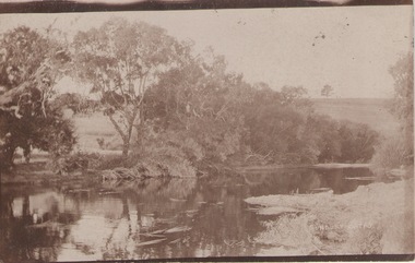
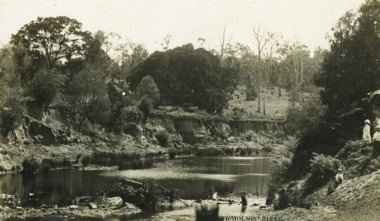
![Victorian Canoe Club: Pound Bend Tunnel [Warrandyte]](/media/collectors/550653872162f11fb04854aa/items/64e4a6590e4970d244f22219/item-media/64e4a6910e4970d244f22a00/item-fit-380x285.jpg) Kew Historical Society Inc
Kew Historical Society IncPhotograph - Victorian Canoe Club, Pound Bend Tunnel [Warrandyte], 1930–35
Canoeing on the River Yarra at Melbourne was an important and widespread recreational pursuit for Melbournians, especially in the first half of the twentieth century. The Victorian Canoe Club was formed in 1912 at a meeting in Melbourne and its first committee elected in the same year. Records indicate that the Club continued into at least the 1950s .The photos in this album are historically and socially significant as a record of recreational activities in the first half of the twentieth century. A number of photographs in the album provide views of sections of the Yarra, as well as areas in regional Victoria, that may otherwise be unavailable.One of 12 sepia [faded] photographs of members of the Victorian Canoe Club. This photo shows members of the club relaxing on the rocks near the Pound Bend Tunnel at Warrandyte."Pound Bend Tunnel"victorian canoe club, travel -- 1930s, canoeing, warrandyte, yarra river -
 Kew Historical Society Inc
Photograph - Historic re-enactment during the Festival of Kew, 1978
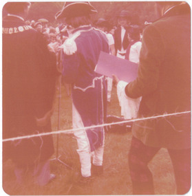
At the 1978 Festival of Kew, a number of organisations, including the City of Kew, the Kew Historical Society, Trinity Boys Grammar School and local Girl Guides participated in a re-enactment of the expedition of the party of Charles Grimes in surveying the Yarra River as far as Kew in February 1803. The location for the event was Yarra Bend Park near the Studley Park Boat House. The event was organised by the Kew Historical Society. The re-enactment was captured by a number of amateur photographers as well as by a photographer from the local Progress Press.Local communities select events to commemorate according to their shared history and values. Commemorations of colonial exploration were popular with local historical groups such as the Kew Historical Society in the twentieth century. In re-enacting events such as the Grimes survey of the Yarra, students from a local school were encouraged to take on specific roles, including play-acting individuals involved in the survey party as well as members of the local Wurundjeri People. The photographs, taken by amateur and professional photographers, represent a period in time when the dominant values were those shared by the descendants of European settlers in Victoria. Original colour photographic positive of a Trinity Grammar School student in period costume reciting the report of his survey of the Yarra at the 1978 Kew Festival. . Annotated on reverse: "GRIMES GIVING A REPORT OF HIS JOURNEY / BACK VIEW"kew historical society, trinity grammar school, kew girl guides, city of kew, yarra river, charles grimes, collins expedition, wurundjeri people, yarra bend park, colonial surveys, historic re-enactments, festival of kew, kew festival -
 Kew Historical Society Inc
Photograph - Yarra River, Kew, 1924
Henry Beater Christian (1886-1962) , was a descendant of one of the earliest settler families in Kew. Employed at the Kew Asylum as a 'public servant', he was a skilled amateur photographer, photographing numerous scenes in Kew and on his travels around Victoria. The majority of his photographs date from 1916 to 1929. His finest photographs are housed in two photograph albums. A dated early photograph of the Zig-Zag Bridge.Digital copy of a photograph from page 1 of the 47-page photograph album containing 261 gelatinous silver images, loaned by Diane Washfold with permission given to digitise and hold a copy in our collection. The image is a closeup view of the Zig-Zag Bridge which was constructed in the 1870s to link the Yarra Bend Asylum and Kew Asylum. "Yarra River Kew 1924"henry beater christian (1886-1962), landscape photography, kew (vic.) — yarra river, christian-washfold collection, photograph albums, zig-zag bridge -
 Kew Historical Society Inc
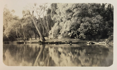
Photograph - Macauley's, Kew, 1924
Henry Beater Christian (1886-1962) , was a descendant of one of the earliest settler families in Kew. Employed at the Kew Asylum as a 'public servant', he was a skilled amateur photographer, photographing numerous scenes in Kew and on his travels around Victoria. The majority of his photographs date from 1916 to 1929. His finest photographs are housed in two photograph albums. A very rare, early panoramic view of Macauley's boat house on the Yarra River at Kew.Digital copy of a photograph from page 2 of the 47-page photograph album containing 261 gelatinous silver images, loaned by Diane Washfold with permission given to digitise and hold a copy in our collection. The photograph is of Macauley's boat sheds on the Yarra River at Kew. The boat sheds was located at the west end of Molesworth Street. The photograph is taken from the Yarra Bend Park side of the river looking down on the boat house from above. The canoes belonging to Macauley's are lined up on the river bank. "Macauley’s Kew"henry beater christian (1886-1962), landscape photography, kew (vic.) — yarra river, christian-washfold collection, photograph albums, macauley's boat sheds -
 Kew Historical Society Inc
Photograph - Macauley's, Kew, 1924
Henry Beater Christian (1886-1962) , was a descendant of one of the earliest settler families in Kew. Employed at the Kew Asylum as a 'public servant', he was a skilled amateur photographer, photographing numerous scenes in Kew and on his travels around Victoria. The majority of his photographs date from 1916 to 1929. His finest photographs are housed in two photograph albums. A fine, early view of Macauley's boat sheds on the Yarra River at Kew.Digital copy of a photograph from page 2 of the 47-page photograph album containing 261 gelatinous silver images, loaned by Diane Washfold with permission given to digitise and hold a copy in our collection. The photograph is of Macauley's boat sheds on the Yarra River at Kew. The boat sheds were located at the west end of Molesworth Street. The photograph is taken from the Yarra Bend Park side of the river, or from a boat on the river. The canoes belonging to Macauley's are lined up on the river bank. "Macauley’s Kew"henry beater christian (1886-1962), landscape photography, kew (vic.) — yarra river, christian-washfold collection, photograph albums, macauley's boat sheds -
 Kew Historical Society Inc
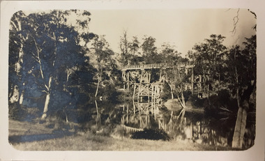
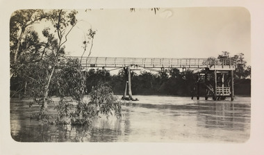
Photograph - Flood, Zig-Zag, Kew, 1924
Henry Beater Christian (1886-1962) , was a descendant of one of the earliest settler families in Kew. Employed at the Kew Asylum as a 'public servant', he was a skilled amateur photographer, photographing numerous scenes in Kew and on his travels around Victoria. The majority of his photographs date from 1916 to 1929. His finest photographs are housed in two photograph albums. A fine and clear view of the Zig-Zag Bridge across the Yarra River.Digital copy of a photograph from page 5 of the 47-page photograph album containing 261 gelatinous silver images, loaned by Diane Washfold with permission given to digitise and hold a copy in our collection. This is a photograph of the 1870s Zig-Zag Bridge that linked the Yarra Bend and Kew Asylums. The Bridge was demolished in 1929."Flood / Zig-Zag / Kew / 1.24"henry beater christian (1886-1962), landscape photography, kew (vic.) — yarra river, christian-washfold collection, photograph albums, zig-zag bridge -
 Kew Historical Society Inc
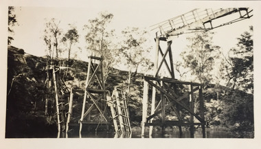
Photograph - Demolishing the Zig-Zag Bridge, 1929
Henry Beater Christian (1886-1962) , was a descendant of one of the earliest settler families in Kew. Employed at the Kew Asylum as a 'public servant', he was a skilled amateur photographer, photographing numerous scenes in Kew and on his travels around Victoria. The majority of his photographs date from 1916 to 1929. His finest photographs are housed in two photograph albums. Rare photograph of the demolition of the Zig-Zag Bridge linking the two asylums on either side of the Yarra River.Digital copy of a photograph from page 16 of the 47-page photograph album containing 261 gelatinous silver images, loaned by Diane Washfold with permission given to digitise and hold a copy in our collection. The Zig-Zag Bridge linked the grounds of the Yarra Bend and Kew Asylums. The wooden bridge was constructed in the 1870s and lasted through numerous floods until its destruction in 1929. A horizontal structure, the walkway was reached via a wooden staircase on the Kew bank of the river. The steps were required due to the different levels of the banks on this stretch of the river. This is a closeup view of the bridge showing the level of destruction caused by the initial damage from the flood and subsequent dismantling of the horizontal struts and walkway, prior to to its destruction by fire."Demolishing Zig-Zag / 6. 1929"henry beater christian (1886-1962), landscape photography, kew (vic.) — yarra river, christian-washfold collection, photograph albums, zig-zag bridge -
 Kew Historical Society Inc
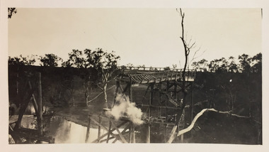
Photograph - Demolishing the Zig-Zag Bridge, 1929
Henry Beater Christian (1886-1962) , was a descendant of one of the earliest settler families in Kew. Employed at the Kew Asylum as a 'public servant', he was a skilled amateur photographer, photographing numerous scenes in Kew and on his travels around Victoria. The majority of his photographs date from 1916 to 1929. His finest photographs are housed in two photograph albums. Rare photograph of the demolition of the Zig-Zag Bridge linking the two asylums on either side of the Yarra River.Digital copy of a photograph from page 16 of the 47-page photograph album containing 261 gelatinous silver images, loaned by Diane Washfold with permission given to digitise and hold a copy in our collection. The Zig-Zag Bridge linked the grounds of the Yarra Bend and Kew Asylums. The wooden bridge was constructed in the 1870s and lasted through numerous floods until its destruction in 1929. A horizontal structure, the walkway was reached via a wooden staircase on the Kew bank of the river. The steps were required due to the different levels of the banks on this stretch of the river. This is a view of the bridge showing the level of destruction caused by the initial damage from the flood, the subsequent dismantling of the horizontal struts and walkway, and the setting on fire of the remaining structure."Demolishing Zig-Zag / 6. 1929"henry beater christian (1886-1962), landscape photography, kew (vic.) — yarra river, christian-washfold collection, photograph albums, zig-zag bridge -
![Bend of the River Watt / [by] Nicholas Caire, circa 1876](/media/collectors/550653872162f11fb04854aa/items/577b52c2d0cdd10948cc9307/item-media/577b5328d0cdd10948ccc8b6/item-fit-380x285.jpg) Kew Historical Society Inc
Kew Historical Society IncPhotograph, Anglo-Australasian Photographic Company, Bend of the River Watt, c.1876
Nicholas Caire was born on Guernsey in the Channel Islands in 1837. He arrived in Adelaide with his parents in about 1860. In 1867, following photographic journeys in Gippsland, he opened a studio in Adelaide. From 1870 to 1876 he lived and worked in Talbot in Central Victoria. In 1876 he purchased T. F. Chuck's studios in the Royal Arcade Melbourne. In 1885, following the introduction of dry plate photography, he began a series of landscape series, which were commercially successful. As a photographer, he travelled extensively through Victoria, photographing places few of his contemporaries had previously seen. He died in 1918. Reference: Jack Cato, 'Caire, Nicholas John (1837–1918)', Australian Dictionary of Biography.An original, rare photograph from the series 'Views of Victoria: General Series' by the photographer, Nicholas Caire (1837-1918). The series of 60 photographs that comprise the series was issued c. 1876 and reinforced a neo-Romantic view of the Australian landscape to which a growing nationalist movement would respond. Nicholas Caire was active as a photographer in Australia from 1858 until his death in 1918. His vision of the Australian bush and pioneer life had a counterpart in the works of Henry Lawson and other nationalist poets, authors and painters.Views of Victoria (General Series) No.26 / 'Bend of the River Watt' / Albumen silver photograph mounted on boardOn Reverse: 'The present illustration represents a scene on the River Watt, and is situated in the valley between Mount Juliet and Mount Monda. The immediate neighbourhood abounds with scenery of the wildest and most romantic character. The River here is as clear as crystal, owing, no doubt, to its bed being composed of rock and pebbles. The banks on either side are studded with foliage so dense as to render access to the neighbourhood almost impracticable.’nicholas caire (1837-1918), australia - landscape photography -
![The Bend of the Yarra at Studley Park / [by] Nicholas Caire, circa 1876](/media/collectors/550653872162f11fb04854aa/items/5783120ed0cdd1176c47d8c8/item-media/57831278d0cdd1176c4805d6/item-fit-380x285.jpg) Kew Historical Society Inc
Kew Historical Society IncPhotograph, Anglo-Australasian Photographic Company, The Bend of the Yarra at Studley Park, c. 1876
Nicholas Caire was born on Guernsey in the Channel Islands in 1837. He arrived in Adelaide with his parents in about 1860. In 1867, following photographic journeys in Gippsland, he opened a studio in Adelaide. From 1870 to 1876 he lived and worked in Talbot in Central Victoria. In 1876 he purchased T. F. Chuck's studios in the Royal Arcade Melbourne. In 1885, following the introduction of dry plate photography, he began a series of landscape series, which were commercially successful. As a photographer, he travelled extensively through Victoria, photographing places few of his contemporaries had previously seen. He died in 1918. Reference: Jack Cato, 'Caire, Nicholas John (1837–1918)', Australian Dictionary of Biography.An original, rare photograph from the series 'Views of Victoria: General Series' by the photographer, Nicholas Caire (1837-1918). The series of 60 photographs that comprise the series was issued c. 1876 and reinforced a neo-Romantic view of the Australian landscape to which a growing nationalist movement would respond. Nicholas Caire was active as a photographer in Australia from 1858 until his death in 1918. His vision of the Australian bush and pioneer life had a counterpart in the works of Henry Lawson and other nationalist poets, authors and painters.‘The Bend of the Yarra at Studley Park’ : Views of Victoria (General Series) No.49 : Albumen silver photograph | Photo on card with Title and Description on reverse | Mounted 24 x 30 cm; Photo 12 x 17 cm.On Reverse: The subject of the present illustration is taken from near the Kew Road, on the Park-hill side of the Yarra. The curve of the River at this and other parts of the Park represents a gigantic letter S. It is a remarkable fact that the hilly side of the River is covered with a mass of foliage of various descriptions, from the stately gum tree to the stunted wattle, whilst the opposite side of flat country has scarcely a shrub to be seen any where.’nicholas caire (1837-1918), studley park, yarra river, kew, landscape photography - victoria -
 Kew Historical Society Inc
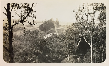
Photograph - Studley Park, 1937
Those sections of Studley Park closest to the River Yarra were set aside as parkland in the 1850s. After initial discussions about whether it was a suitable site for a Government House, much of the land was instead gazetted in the 1860s as the location for a new lunatic asylum, to expand overcrowded mental health facilities at the Yarra Bend Asylum on the other side of the river at Fairfield. Those sections of Studley Park bounded by the Yarra River, Studley Park Road, Princess Street and Fellows Street were subdivided and sold at the Crown Land Sales in 1851. Much of this urban area remained open farmland until the twentieth century, apart from mansions, largely located along the main roads.Original, black and white positive print of what is said to represent Studley Park in 1937. If the attribution and date is literally to be understood, then it would appear that the photograph may have been taken from the Kew side of the river looking across to open farmland in the Yarra Bend Park. If the designation of Studley Park is to be understood more loosely, then it might be a view of what is now East Kew, taken from a section of Kilby Road. Inscribed verso: "Studley Park 1937" studley park -- kew (vic.) -
 Brimbank City Council Art Collection
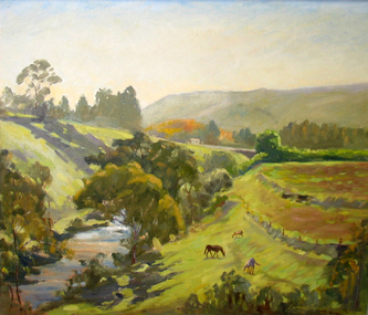
Painting, Maribyrnong River from Horseshoe Bend Road, Keilor, 1977
Local SceneImpressionistic view of valley with a creek running through it. Three horses in the foreground - AR0064Information about the artist on the back. "James Farrell is a member of the Victorian Artists Society" and "is represented at the Australian War Memorial, Canberra".keilor, maribyrnong, river, painting, impressionist, landscape -
 Sunbury Family History and Heritage Society Inc.
Photograph, SUNBURY BATHS
The scene featured on the post card is a view of The Nook on the Jacksons Creek. For many years before the Aquatic Centre was build in the town, The Nook was the swimming place for local residents. The surrounding area had seats and change rooms. The Sunbury Swimming club was established at this site before the Aquatic Centre was built.A sepia photograph in post card format of river bend and small sandy beach on the bank.the nook, swimming -
 Williamstown Botanic Gardens- Hobsons Bay City Council
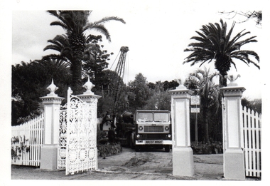
Photos - Cannons, 1970
The Armstrong Cannons were originally placed at Fort Gellibrand, located at the southernmost tip of the Williamstown peninsula. The Fort was developed during the 1850s as part of a defensive system for the city and port of Melbourne. The importance of the Fort batteries declined from the 1890s, when they were effectively replaced by new facilities at Queenscliff and Point Nepean, but they were still used for gunnery practice. Local residents, through the Williamstown Town Council, complained to the Acting Minister for Defence that the concussion from the guns damaged windows, walls and foundations of buildings. The Armstrong Cannons were moved from Fort Gellibrand to the Gardens in 1906. A primary source of evidence of the cannons being in the Gardens. The cannons are remembered fondly as play equipment for the local children. Many tales have been told of climbing over them and pretending to be shot out of them A collection of seven black and white photographs documenting the removal of the cannons from the Gardens Photo 1 (a) Black and white landscape image. View is looking through the main gates looking at the front of the truck, which has the name Walter Wright across the front bumper, the crane and canon. The gates and fence are painted a light colour, probably white. Photo 2 (b) Black and white landscape image. Back of loader with cannon on it. Man standing on top of the cannon bending over either tying or untying ropes. Trunk of a palm tree is on the left side of the photo with a top of a palm tree in the background. Photo 3 (c) Black and portrait white image. A cannon being loaded by the crane on to trailer. Palm tree is in the background and fronds from a palm tree can be seen in the right top corner. Photo 4 (d) Black and white landscape image. Side on view of a cannon on the truck parked outside the grounds of the Gardens. The logo of the name of the trucking company is on the door of the truck above the words ‘WALTER H WRIGHT / TRANSPORT PTY LTD / S SCHULZ ST WEST MELB’. A second cannon can be seen in the background. A bus is in the background on the middle right side of the image. Photo 5 (e) Black and white landscape image. Truck with cannon on the back leaving the ground of the Gardens. Tree on the right side of the image and power pole is behind the truck. The logo of the name of the trucking company is on the door of the truck above the words ‘WALTER H WRIGHT / TRANSPORT PTY LTD / S SCHULZ ST WEST MELB’. ‘WALTER WRIGHT’ is on the front bumper Photo 6 (f) Black and white landscape image. Cannon tied down on the back of the truck as it is being driven across the street. Three houses in the background and two cars, one is a Volkswagen Photo 7 (g) Black and white landscape image. Cannon on the back of the truck which is parked over the street from the Gardens. Three houses are in the background. Two trees bare of leaves. The front of a car in in the foreground – it has a sun visor and the steering wheel is a light colour.armstrong cannons, williamstown botanic gardens, hobsons bay city council, 1970, walter h wright / transport pty ltd -
 University of Melbourne, Burnley Campus Archives
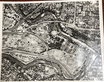
Photograph - Black and white print, Aerial View of Burnley Campus, 1977
Framed enlargements. (A) Burnley College and surrounding suburbs showing the nearly constructed Freeway, the College in the bend of the Yarra River, Glenferrie Road to the East Swan Street to the North. (B) Enlargement of (A) showing detail of Burnley College.burnley college, suburbs, freeway, yarra river, glenferrie road, east swan street, aerial view -
 University of Melbourne, Burnley Campus Archives
Photograph - Black and white print, Aerial View of Burnley Campus C.1970, c. 1970
Colour photograph of black and white photograph. Aerial View of Burnley Campus. Enlargement. Shows position of Campus in bend of Yarra River after alterations to the position of the river due to building of Freeway, new ovals and Richmond Public Golf Course.burnley campus, aerial view, yarra river, richmond public golf course -
 Lakes Entrance Historical Society
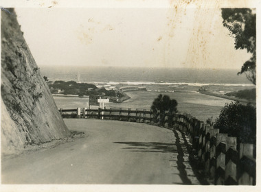
Postcard - The Entrance, Bulmer H.D, 1940c
Black and white small format postcard showing a bend in the Princes Highway on the Kalimna Hill. The road runs between the steep road cutting and post and rail guard fence. The artificial entrance from Bass Strait to Lakes system is in view. Lakes Entrance Victoriawaterways, islands -
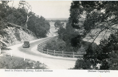 Lakes Entrance Historical Society
Postcard - Princes Highway Kalimna, Bulmer H D, 1935c
Black and white postcard of the Princes Highway as it winds around Jemmys Point. A motor car driving up the hill between steep road cutting and post and rail fence. View of the lake and ocean in the distance. Lakes Entrance VictoriaBend in Princes Highway, Lakes Entrance fences, roads and streets -
 Sunbury Family History and Heritage Society Inc.
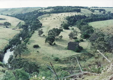
Photograph, Lochton Mill at Bulla, C1980s
The building in the photograph is a present day view of the former Lochton Mill which was built on a bend of Deep Creek in Bulla on 1856 on property owned by Captain William Morrison Hunter. Lochton Mill was one of a few mills that were set-up on the banks of Deep Creek in Bulla and Jacksons Creek in Sunbury.A non-digital coloured photograph of the ruins of a bluestone mill that was built on a bend of a river. It is an elevated view and clearly shows the river's course in the deep valley as well as the surrounding hilly countryside. lochton mill, bulla, deep creek, captain william morrison hunter, milling -
 Lakes Entrance Historical Society
Postcard, 1970
Postcard has long personal message on reverse.Colour postcard taken at a bend in the Princes Highway approaching Lakes Entrance, showing a car travelling downhill, two cars parked with five people viewing the entrance from Bass Strait. Lakes Entrance Victoriawaterways, islands -
 Stawell Historical Society Inc
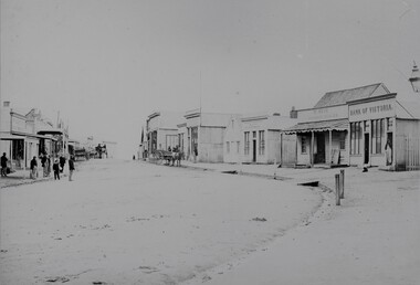
Photograph, Upper Main Street with the London Chartered Bank on the right, Mr W Muir Produce Dealer & the Bank of Victoria 1866
Main Street. On Right is London Chartered Bank. W Muir Produce Dealer. Bank of Victoria. Part of a collection of Photographs by Mr. O.G. Armstrong as commissioned by the Shire of Stawell for the Inter-colonial and Paris Exhibition in Melbourne in 1866. Another view of the top or eastern end of Main Street 1866. It is almost the same area as in photo No 14 but looking westward towards the Grampians. Streetscape with bend of road in foreground. Bank of Victoria prominent on right side of image.stawell businesses streetscape -
 Lakes Entrance Historical Society
Postcard - Nicholson River, Bulmer and Segenberg Bairnsdale, 1910
Also a second black and white postcard showing two rowboats on river at wide bend 05350.1 8.5 x 13.5 cmBlack and white postcard showing view of Upper Nicholson River with three women shown, water level low Nicholson VictoriaNicholson River waterways, boats and boating -
 Lakes Entrance Historical Society
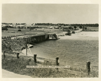
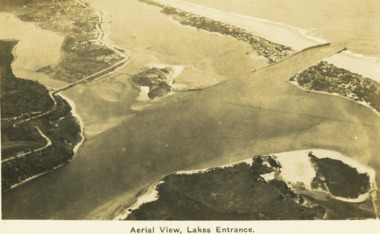
Postcard - Aerial view Lakes Entrance, H D Bulmer, 1922 c
Image clearly shows new alignment of Princes Highway around Jemmys Point and part of the original high road to the first bend above North Arm BridgeBlack and white postcard aerial view of the western area of the town, Bullock Island and Snake Island and waterways Lakes Entrance VictoriaAerial View Lakes Entrancewaterways, islands, township -
 Lakes Entrance Historical Society
Photograph - Views from Jemmys Point, Lakes Entrance c1960, 1960 c
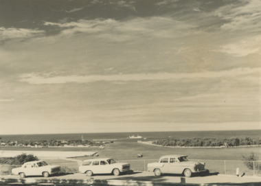
Black and white photograph of the entrance taken from a bend in the Princes Highway showing three cars parked at the viewing area beside the highway. Boat and dredge in waterway below highway dredged sand in Bullock Island extension, dredge Mathew Flinders working outside the entrance Lakes Entrance Victoria. Also two black and white photographs taken of Entrance from Jemmys Point taken 1960 c waterways, vehicles, islands, roads and streets -
 Lakes Entrance Historical Society
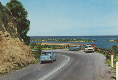
Postcard - Princes Highway Lakes Entrance, AFK International Publishers, 1970 c
Parking bay for viewing the Entrance situated on a sharp bend of the Princes Highway. Also in image part of Bullock Island and New Works area. Three motor cars in picture, post and rail safety fence Lakes Entrance Victoria. Also three colour postcards of same view showing progress at parking bay to steel mesh fence and steel guard rails numbers 04206.1, size 9 x 14 cm, 04206.2, 04206.3 size 10 x 14.5 cmColour postcard showing parking bay for viewing the Entrance situated on a sharp bend of the Princes Highway. Also in image part of Bullock Island and New Works area. Three motor cars in picture, post and rail safety fence Lakes Entrance Victoriacivil engineering, islands, waterways, gippsland lakes, vehicles