Showing 243 items matching " waterfront"
-
 Lakes Entrance Historical Society
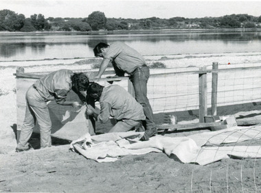
Photograph, Lakes Post Newspaper, 1991
Date made June 1991Black and white photograph of work in progress during the development of the recreational area beside Cunninghame Arm. It shows three men building a shelter fence, to protect proposed plantings of native trees and shrubs. Lakes Entrance Victoria vegetation, waterfront -
 Lakes Entrance Historical Society
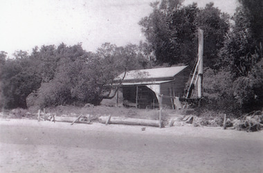
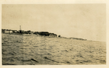
Photograph - The Beacons, 1910c
Black and white photograph showing cottage, The Beacons, on dune, beacon pole to right of cottage, trees and vegetation on dune, logs along beachfront to stop erosion. Lakes Entrance Victoria waterfront, historic buildings -
 Lakes Entrance Historical Society
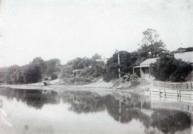
Photograph - New Cottages, 1910c
Black and white photograph showing cottages on dunes, nearest cottage, At Rest, next one The Beacons, Cunninghame Arm in front. Picket fence in front of At Rest, at Lakes Entrance, Victoria.houses, waterfront -
 Lakes Entrance Historical Society
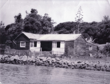
Photograph - Schnapper Cottage, 1944
Black and white photograph showing, Schnapper cottage on western side of entrance. Dark weatherboards, front partially screened in, picket fence along front, rocks along shoreline, thick vegetation on dunes, tall century plant at rear of house. Lakes Entrance Victoria waterfront, historic buildings -
 Lakes Entrance Historical Society
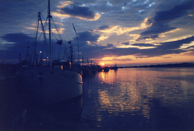
Photograph, Shepherd, Dennis, 1985
Colour photograph taken from boat harbour of sunrise reflections on Cunninghame Arm. Fishing vessel Ken Dean in foreground. Lakes Entrance Victoriawaterfront, boats and boating -
 Lakes Entrance Historical Society
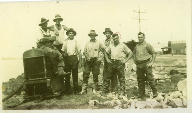
Photograph, 1930c
Men - from right- F Worseldine, R Martin, E Bourke, B SmithBlack and white photograph snapshot of Tambo Shire workers constructing retaining wall along Cunninghame Arm, after WW1. Four men on right. Photograph presumed to be opposite present McDonald's restaurant. Lakes Entrance Victoria waterfront, maintenance -
 Lakes Entrance Historical Society
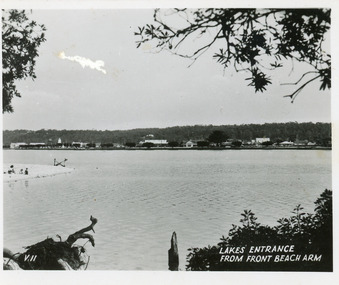
Postcard, 1945c
Black and white small format postcard showing a distant view of the town, taken from the southern shore of the lake. The view shows a glimpse of the beach known formerly as Play Point, the picture framed by native vegetation. Lakes Entrance VictoriaLakes Entrance from front beach armtownship, waterfront -
 Lakes Entrance Historical Society
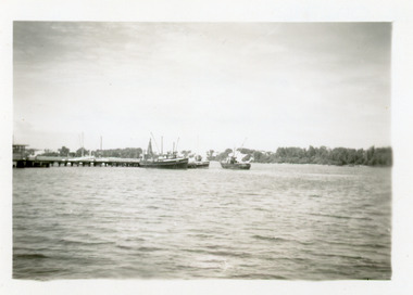
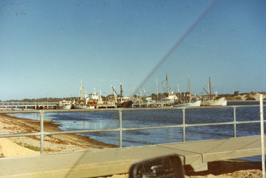
Photograph - Boat Harbour, 1950c
Black and white small format photograph of one arm of the boat haven harbour, showing fishing boats moored in the lake, south shore of the lake in background. Lakes Entrance Victoriawaterfront, boats and boating -
 Lakes Entrance Historical Society
Photograph - Lakeside, Holding George, 1984c
Part of a series of seven colour photographs taken from same spot on the same dayColor photographs showing progress of extension to lakeside at the West boat Harbour, taken from the car park, showing many moored vessels. In the foreground the sand dredged from other areas and dumped in order to extend the car park and lakeside walkways. Lakes Entrance Victoriawaterfront, boats and boating -
 Lakes Entrance Historical Society
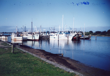
Photograph - Bank Jetty, Soderlund Olav, 1993c
Color photograph of Bank Jetty, showing some of the fishing fleet moored around the jetty. In background the scrub covered hummocks, forming the southern shore of Cunninghame Arm in the foreground the sandy shore strewn with seagrass below the bluestone lake wall and lawn. Lakes Entrance Victoriawaterfront, fishing industry -
 Lakes Entrance Historical Society
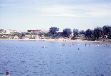
Photograph, Nelson Joan, 1980c
Colour photograph of a crowd on the beach at the southern shore of Cunninghame Arm. It shows many people enjoying the sand and water, footbridge and northern shore of township in distance. Lakes Entrance Victoriawaterfront, recreation -
 Lakes Entrance Historical Society
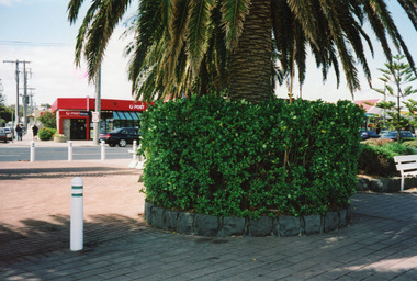
Photograph - Post Office, LERHS, 1999c
Paving was completed November 1993.Colour photograph of the forecourt of the Post Office Jetty, showing paved area, palm tree in circular garden. Norfolk Island pine in distance. Post Office over the road. Lakes Entrance Victoriawaterfront, postal services -
 Lakes Entrance Historical Society
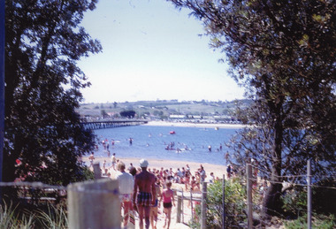
Photograph, Nelson Joan, 1980c
Colour photograph of the beach at the southern shore of Cunninghame Arm. It shows people swimming and paddling, also on the beach, coastal banksia and scrub on sand hummocks, surf lifesaving clubrooms in background. Lakes Entrance Victoriawaterfront, recreation -
 Lakes Entrance Historical Society
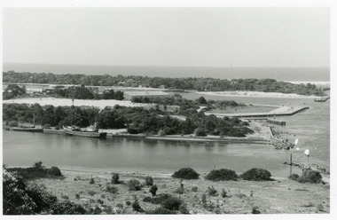
Photograph - Bullock Island, 1990c
Black and white photograph of the entrance. It shows two fishing boats moored in North Arm, western end of Bullock Island with Fishermens Co-op building, and area below Jemmys Point, both formed during dredging operations over many years. Lakes Entrance Victoria waterfront, islands -
 Lakes Entrance Historical Society
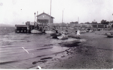
Photograph - New Works Jetty, Phillips, Miss L, 1900c
Black and white photograph showing New Works jetty with shed on end. Wooden fish boxes stacked at end of shed. Three boats at jetty, two rowing boats at waters edge, two small children, one in boat, one on beach. Lakes Entrance Victoria waterfront, jetties -
 Lakes Entrance Historical Society
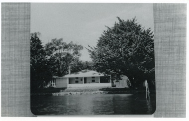
Photograph - Carpenter house, 1989c
Photo taken of photo in albumBlack and white photograph showing present day Carpenter House on Hummocks at New Works. Cyprus trees either side well grown, twin gables replaced by hip roof, neat lawn and rock retaining wall along lakeside. Lakes Entrance Victoria waterfront, historic buildings -
 Lakes Entrance Historical Society
Photograph - Eastern Pier, 1925c
Also black and white print 10 x 17.5 cmBlack and white photograph showing Eastern Pier and Entrance to Gippsland Lakes from Bass Strait. Works machinery, buildings, cranes etc still in place. Lakes Entrance Victoria waterfront, piers -
 Lakes Entrance Historical Society
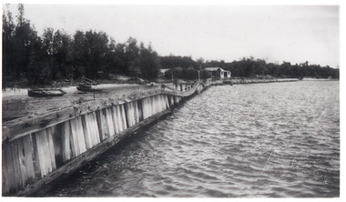
Photograph - Hopetoun Channel, 1946
Black and white photograph showing walings along shoreline west of entrance piers and Schnapper Cotttage further along. Dense vegetation on dunes, several small boats on beach behind walings, Hopetoun channel right foreground. Lakes Entrance Victoriahouses, waterfront -
 Lakes Entrance Historical Society
Book, Department of Conservation and Environment, Lake Tyers Foreshore Reserves Management Plan, 1991
An approved management plan relating to the public foreshore land between Lake Bunga and Mill Point. Contains plans and appendices.waterfront, vegetation -
 Lakes Entrance Historical Society
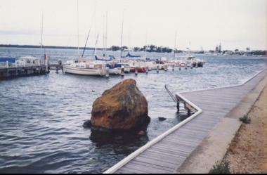
Photograph, M Holding, Boardwalk Metung Victoria, 1/11/1999 12:00:00 AM
Colour photograph of Metung Rock in the lake between the boardwalk and Marina, in distance the village of Metung Victoriapublic works, waterfront -
 Lakes Entrance Historical Society
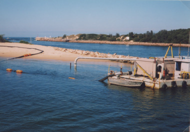
Photograph, small dredge Lakes Entrance Victoria, 1/04/1999 12:00:00 AM
Colour photograph of small dredge and pipeline from dredge across sand beside entrance at launch of six month trial of sand transfer pumping system at New Works area Lakes Entrance Victoria. Plus two other photos including Barrie Martin of Gippsland Ports, Marie Tehan Minister for Conservation Forests and Land, environment, waterfront -
 Lakes Entrance Historical Society
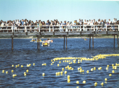
Photograph - Cunninghame Arm footbridge, LE Tidy Town Committee, Lakes Entrance Victoria, 1994 c
Also a colour photograph of four people at picnic table adjacent to Northern end of Cunninghame Arm Footbridge Lakes Entrance 05158.1. 10 x 15 cmColour photograph showing crowd of people on Cunninghame Arm footbridge at start of the Duck Race a local fundraiser with paddle boats in background Lakes Entrance Victoria. Also a colour photograph of four people at picnic table adjacent to Northern end of Cunninghame Arm Footbridge Lakes Entrancewaterfront, bridges -
 Lakes Entrance Historical Society
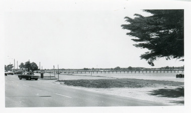
Photograph - Footbridge, footbridge and Princes Highway Lakes Entrance Victoria, 1990c
Small format, black and white photograph of the footbridge and Princes Highway. It shows cars parked beside the road, footbridge, lake, and part of a WW1 memorial cypress tree in foreground. Lakes Entrance Victoria waterfront, foreshore -
 Lakes Entrance Historical Society
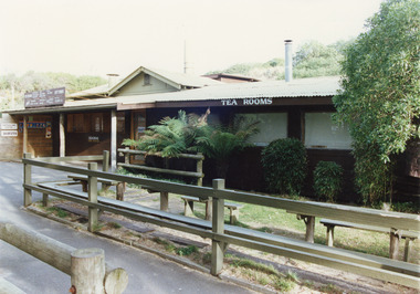
Photograph - Tea Room, Tambo Shire, kiosk on the hummocks. Lakes Entrance Victoria, 1980c
This is the before paired photograph used in the 150 year Lakes Entrance 1858-2008 display.|The after paired photograph number is 01544.1|Also one 12 x 16 framed photograph used in room display.Colour photograph of the kiosk on the hummocks. It shows the recently renovated and extended kiosk and garden, nestling beside the scrub covered sand hummock. Rustic picnic tables and seats inside garden grounds. Lakes Entrance Victoriawaterfront, restaurant -
 Lakes Entrance Historical Society
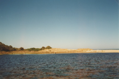
Photograph - Lake Bunga, M Holding, 1990c
Colour photograph of eastern shore near the entrance to ocean, the low area between upland and sand dune indicating the original waterway Lake Bunga Victoriatopography, waterfront -
Port Melbourne Historical & Preservation Society
Photograph - Port Melbourne's changing waterfront, Ron Laing, 1999
Part of Ron Laing's collection of photographs recording Port Melbourne over a thirteen year period. Donated to the PMH&PS by the photographer.A set of 34 colour photographs of Port Melbourne's changing waterfront, covering the old and new harbor control tower on Fishermens Bend, restoration of the outer beacon, reconstruction of the west wing of Station Pier, demolition of the concrete 'steps' breakwater at Port Melbourne, reconstruction of the foreshore - Sandridge Beach to Beacon Roadbuilt environment, natural environment, demolitions, piers and wharves, ron laing -
 Mission to Seafarers Victoria
Photograph - Photograph, Black and white, circa 1960s
The Geelong Rest located at 3 Moorabool Street was created in 1895. The building depicted in the photograph ( taken from the Western Beach Road) is known as the King Edward VII Sailors' Rest building; it was designed by architect Percy Everett and replaced the older building in 1912. In 1901, it became the Geelong branch of the Mission to Seamen. The building is still standing on the waterfront in Geelong and has a commercial use.Medium b & w photograph depicting the front facade of the Sailors' Rest in Geelong.geelong, sailors' rest, seafarer, king edward vii sailors' rest building, 1912, percy everett, kombi -
Port Melbourne Historical & Preservation Society
Photograph - Station Pier, Port Melbourne, Lyn Allison, Mar 1993
Colour photograph showing Station Pier with West kiosk still in original location and some foreshore work in progress taken 8th Match 1993. In the foreground a sheoak (casuarina species) is visible and is of interest as it is still there in 2015 after so much change has occurred in the area (opposite 1-11 Waterfront Place)piers and wharves - station pier, natural environment - beaches and foreshore, abel tasman -
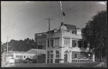
 National Wool Museum
Sign
Metal sign (one of two- the other is missing) that previously hung on one side of the main entrance door at Dalgety Wool Store on Gheringhap St (now Deakin University waterfront campus). Sign was polished daily by Percy Johnson, a janitor at the building in the 1960's. Donor worked at the building as a clerk between 1958 - 1982. Sign was found by a metal collector by the side of the road c.2018. Metal sign with pressed text. Possibly brass. May have originally been gold colour but now a dull brown. Text is cracked and shows losses in some places. Four screw holes, one at each corner.AGENT FOR DALGETY AND COMPANY LIMITED (INCORPORATED IN ENGLAND) WOOLBROKERS -
 Lakes Entrance Historical Society
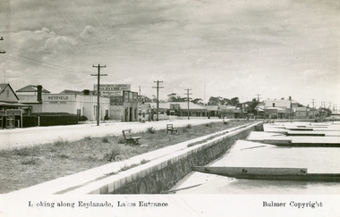
Postcard - Lakes Entrance, Bulmer H D, 1940c
Black and white postcard of Esplanade, showing timber sand groynes, rock wall, concrete footpath along the foreshore. Across the highway from left to right Kia-Ora House, Heyfield House, Coates Bros Garage, Robin Hood Inn, Vises Cafe, Methodist Church, Bellevue Guesthouse, Police Station, Maranui Guesthouse and Glenara Guesthouse. Lakes Entrance VictoriaLooking Along The Esplanade Lakes Entrancewaterfront, township, accommodation