Showing 268 items matching " williamstown road"
-
 Port Melbourne Historical & Preservation Society
Plan - Raglan Street from Williamstown Street to Ross Street, 14 Mar 1893
... Plan of Raglan Street from Williamstown Road to Ross Street... of Raglan Street from Williamstown Road to Ross Street, 1893 Plan ...Plan of Raglan Street from Williamstown Road to Ross Street, 1893engineering - roads streets lanes and footpaths, town planning, town clerks, mayors, arthur victor heath, james john bartlett -
 Port Melbourne Historical & Preservation Society
Photograph - Port Melbourne Boys band, Bill Goudie and other band members, c 1942
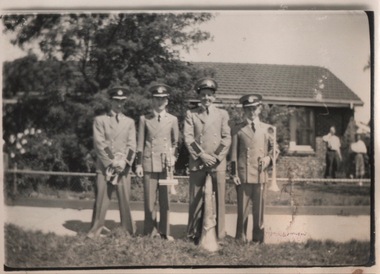
... Bill Goudie and other band members outside 236 Williamstown... members outside 236 Williamstown Road Bill Goudie and other band ...Bill Goudie was a member of the Port Melbourne Boys Band in the late 1930s. He is on the right of the photo (with trombone) and Harold McLeish (with cornet) is on the left. Goudie was born in 1939 and would be about 13 in the photoBill Goudie and other band members outside 236 Williamstown Roadarts and entertainment - community arts, bill goudie, harold mcleish -
Port Melbourne Historical & Preservation Society
Plan - Traffic census, Port Melbourne, 6 Mar 1947
... at Ingles Street and Williamstown Road (no 84), Lorimer Street... and Williamstown Road (no 84), Lorimer Street and Salmon Street )no 90 ...Traffic census 6th March 1947 showing intersections at Ingles Street and Williamstown Road (no 84), Lorimer Street and Salmon Street )no 90) Beach Street and Bay Street (no 113) Williamstown Road and Beach Road (no 112), Railway Crossing Graham Street (no 77)engineering - roads streets lanes and footpaths -
Port Melbourne Historical & Preservation Society
Photograph - Aerial view over Yarra River and Port Melbourne, 18 Jun 1940
... Melbourne in the middle. Background - Williamstown Road is visible.... Background - Williamstown Road is visible at the top of the picture ...Aerial photograph overlooking the Yarra River with Port Melbourne in the middle. Background - Williamstown Road is visible at the top of the picture.piers and wharves - miscellaneous, built environment - commercial, malcolm moore ltd, north wharf, south wharf, nordfest -
Port Melbourne Historical & Preservation Society
Map - City of Port Melbourne, Department of Lands and Survey, 29 Nov 1938
... area and down to Williamstown Road (Kitchens etc). 1938... - Fishermens Bend area and down to Williamstown Road (Kitchens etc ...Printed map of City of Port Melbourne - Fishermens Bend area and down to Williamstown Road (Kitchens etc). 1938Red pencil marks through existing Lorimer St (refer 306)built environment - industrial, health - general health, fishermans bend, j kitchen & sons pty ltd -
 Port Melbourne Historical & Preservation Society
Photograph - Short Road ferry crossing Yarra from west side, 1930
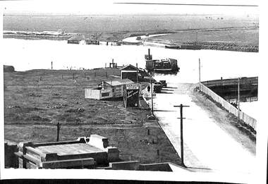
... williamstown road... and wharves short road ferry williamstown road Black and white ...Black and white photograph of Short Road ferry crossing the Yarra, taken from the west side. Roads on both sides with cars. Buildings on west side.piers and wharves, short road ferry, williamstown road -
Port Melbourne Historical & Preservation Society
Document - Mrs Mary barrett's connection to Holy Trinity Anglican Church, Port Melbourne
... williamstown road... - anglican (holy trinity) mary barrett williamstown road Hand written ...Hand written description detailing Mrs Mary Barrett's connection to the Holy Trinity Church of England. The description details the author's memories of Mary Bennettreligion - anglican (holy trinity), mary barrett, williamstown road -
Port Melbourne Historical & Preservation Society
Document, Recollections of Holy Trinity's earlier days
... williamstown road... - anglican (holy trinity) mary barrett williamstown road ...Recollections of Holy Trinity's earlier days. Copy of description detailing Mary Barrett's connection to the Holy Trinity Church. Further detail is given about the song mentioned in the author's memories of Mary Barrettreligion - anglican (holy trinity), mary barrett, williamstown road -
 Port Melbourne Historical & Preservation Society
Photograph - Relating to Malcom Moore Pty Ltd, 1948 - 1988
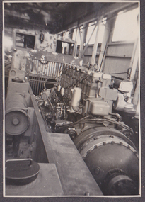
... to donor. Moore's premises were in Williamstown Road... to donor. Moore's premises were in Williamstown Road ...Collected by donor's father Norm Robinson during his 40 year employment with Malcolm Moore between 1948 and 1988.Photos of worksites, machinery, manufactured equipment for Malcolm Moore's. Selection taken from photo album now returned to donor. Moore's premises were in Williamstown Road (approximately where Bunnings is now)industry, built environment - industrial, norm robinson, malcolm moore pty ltd -
Port Melbourne Historical & Preservation Society
Map - MMBW Map Area No 56, after 1911
... . In particular houses in Bridge Street between Williamstown Road.... In particular houses in Bridge Street between Williamstown Road ...The map is based on the 1894 MMBW map (Cat No 271) but shows buildings that were constructed after this date. In particular houses in Bridge Street between Williamstown Road and Derham Street, buildings between the right of way and Derham Street and Williamstown Road including an A T Harmon building constructed in 1911. There are also houses at the top end of Derham Street near Williamstown Road.Photocopy of a section of a larger MMBW map created after 1911.engineering - board of works, built environment, alfred thomas harmon -
 Melbourne Tram Museum
Negative, Wal Jack, 20/04/1945 12:00:00 AM
... of Williamstown Road. Photo dated 20-4-1945 in the Wal Jack album along... of Williamstown Road. Photo dated 20-4-1945 in the Wal Jack album along ...Black and white negative, by Wal Jack, of X1 464 possibly at the Ballarat Road terminus. The tram has the destination of Williamstown Road. Photo dated 20-4-1945 in the Wal Jack album along with details of the location and the tramcar.trams, tramways, footscray, world war 2, x1 class, ballarat road, tram 464 -
Port Melbourne Historical & Preservation Society
Document - Short Road Ferry ticket, c.1974
... ferry ran between the end of Williamstown Road in Port Melbourne... from Williamstown on the Short Road Ferry. The off white ticket... the end of Williamstown Road in Port Melbourne across ...From the collection of Warren DOUBLEDAY. The Short Road ferry ran between the end of Williamstown Road in Port Melbourne across the narrowest section of the Yarra River to the bottom of the Strand in Williamstown. The name came from it being the 'short road' between the two places. There was a type of ferry service in operation from around 1873 which was modernised in the 20th century to take cars and trucks across the river. It was operated by two heavy chains which sank to the river bed to allow ships to pass.A single trip 15 cent ticket for crossing the Yarra River from Williamstown on the Short Road Ferry. The off white ticket has two diagonal blue stripes and the number P016322 printed on the side. transport - ferries, short road ferry, williamstown, transport - motor vehicles -
Port Melbourne Historical & Preservation Society
Document - Short Road Ferry ticket 1974, 7 Jan1974
... ferry ran between the end of Williamstown Road in Port Melbourne... from Williamstown on the Short Road Ferry. The off white ticket... the end of Williamstown Road in Port Melbourne across ...From the collection of Warren DOUBLEDAY. The Short Road ferry ran between the end of Williamstown Road in Port Melbourne across the narrowest section of the Yarra River to the bottom of the Strand in Williamstown. The name came from it being the 'short road' between the two places. There was a type of ferry service in operation from around 1873 which was modernised in the 20th century to take cars and trucks across the river. It was operated by two heavy chains which sank to the river bed to allow ships to pass.A single trip 20 cent ticket for crossing the Yarra River from Williamstown on the Short Road Ferry. The off white ticket has two diagonal blue stripes and the number C049655 printed on the side. On reverse side of ticket -" 8.25 pm trip. 7-1-74 (last East bound for day'"transport - ferries, short road ferry, williamstown, transport - motor vehicles -
Port Melbourne Historical & Preservation Society
Document - Short Road Ferry ticket, c.1974
... ferry ran between the end of Williamstown Road in Port Melbourne... from Williamstown on the Short Road Ferry. The off white ticket... the end of Williamstown Road in Port Melbourne across ...From the collection of Warren DOUBLEDAY. The short Road ferry ran between the end of Williamstown Road in Port Melbourne across the narrowest section of the Yarra River to the bottom of the Strand in Williamstown. The name came from it being the 'short road' between the two places. There was a type of ferry service in operation from around 1873 which was modernised in the 20th century to take cars and trucks across the river. It was operated by two heavy chains which sank to the river bed to allow ships to pass.A single trip 15 cent ticket for crossing the Yarra River from Williamstown on the Short Road Ferry. The off white ticket has two diagonal blue stripes and the number F 048261 printed on the side. transport - ferries, short road ferry, williamstown, transport - motor vehicles -
Port Melbourne Historical & Preservation Society
Photograph - Malcolm Moore advertising, c.1960
... in Williamstown Road, Port Melbourne in 1927.... Moore Engineering Works Pty Ltd was established in Williamstown ...Malcolm Moore Engineering Works Pty Ltd was established in Williamstown Road, Port Melbourne in 1927.Digital image of advertising for Malcolm Moore Engineering Works.malcolm moore pty ltd -
 Port Melbourne Historical & Preservation Society
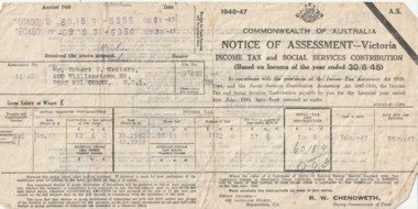
Financial record (Item) - Tax Assessment notice, Commonwealth of Australia, 16 May 1947
... Williamstown Road, Port Melbourne.... Williamstown Road, Port Melbourne. Robert Cornelius WATTERS Finance ...The 1946-7 Tax Assessment is for Mr Robert C WATTERS of 400 Williamstown Road, Port Melbourne.60189/993robert cornelius watters, finance -
 Port Melbourne Historical & Preservation Society
Photograph - Aerial view of first Bank Houses in Garden City, 1927
... Street and Williamstown Road, west wing of Station Pier... Street State School, Princes Pier, Graham Street and Williamstown ...Photographic copies from black and white aerial photograph of the building of the first State Savings Bank Houses in Garden City 1927, showing also Graham Street State School, Princes Pier, Graham Street and Williamstown Road, west wing of Station Pier ("Rotomahana" at pier)built environment - domestic, fishermans bend, garden city, education - primary schools, melbourne harbor trust - port of melbourne authority, state savings bank of victoria, graham street state school, port melbourne primary school, bank houses -
 Port Melbourne Historical & Preservation Society
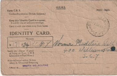
Card (Item) - Australian WW2 Identity Card, c.1940
... who lived at 400 Williamstown Road, Port Melbourne... Williamstown Road, Port Melbourne and was employed at the Myer Emporium ...The WW2 identity card was issued to Norma Madeline WATTERS who lived at 400 Williamstown Road, Port Melbourne and was employed at the Myer Emporium, Bourke Street , Melbourne.norma madeline watters, war - world war ii -
Port Melbourne Historical & Preservation Society
Photograph - Various streets in Port Melbourne, Ron Laing, 1990 - 1999
... wrecking), Bain Street, Graham overpass, Williamstown Road..., Graham overpass, Williamstown Road, Normanby Road, Ross Street ...Part of Ron LAING's collection of photographs recording Port Melbourne over a thirteen year period. Donated to the PMH&PS by the photographer.A set of 49 colour photographs of varous streets in Port Melbourne, including Graham Street, Swallow Street (before and after wrecking), Bain Street, Graham overpass, Williamstown Road, Normanby Road, Ross Street and Bay Street, Princes Street March 1999 (Number 48 missing August 2015)built environment, ron laing -
 Melbourne Tram Museum
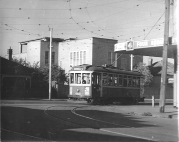
Photograph - Footscray - Buckley St tram 460, Jim Seletto, c1960
... Williamstown Road. There is a Four Square grocery shop on the corner.... Williamstown Road. There is a Four Square grocery shop on the corner ...The photograph shows MMTB X1 class No. 460 in Buckley Street turning into Nicholson St on its way to Russell St from Williamstown Road. There is a Four Square grocery shop on the corner.Yields information about trams in Buckley St Footscray c1960.Black and White photograph with photographer's notes on rear"J Seletto photo"trams, footscray, x1 class, tram 460, buckley st -
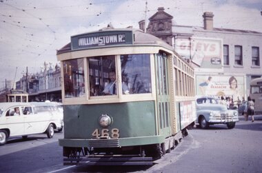 Melbourne Tram Museum
Slide - X1 468 turning into Leeds St Footscray, Tramway Museum Society of Victoria (TMSV), early 1960s
... into Leeds St with the destination of Williamstown Road. Another X1... into Leeds St with the destination of Williamstown Road. Another X1 ...Colour slide of X1 468 turning from Hopkins St Footscray into Leeds St with the destination of Williamstown Road. Another X1 class tram can be seen in the background bound for Russell Street.Yields information about X1 class in Footscray.Kodachrome colour slides, cardboard mount, duplicate.Stamped "Tramways Museum Society Victoria" and "Windsor Publications" on rear along with number 0228leeds st, hopkins st, tram 468, x1 class, mmtb, footscray, tramways, trams -
Port Melbourne Historical & Preservation Society
Functional object - Missions to Seamen building, Port Melbourne, BI Ltd, 1937
... them to pave their yard at 488 Williamstown Road. She and David... their yard at 488 Williamstown Road. She and David saved two for PMH ...Liana THOMPSON, Mayor of Port Phillip at the time, purchased many of the bricks from the demolished Mission and used them to pave their yard at 488 Williamstown Road. She and David saved two for PMH&PSTwo bricks from the 1937 Missions to Seamen building demolished 1995. Salmon coloured, with bits of mortar; impressed one side with 'BI Ltd'mission to seamen, demolitions, liana thompson, harry a norris -
Port Melbourne Historical & Preservation Society
Photograph - Joint birthday party for Nellie Thackruh and Amelia Finch, Mission Arts Centre, Missions to Seamen buiding, Port Melbourne, Alison Kelly, 4 Feb 1988
... held at Mission for Nellie Thackruh of 444 Williamstown Road... party held at Mission for Nellie Thackruh of 444 Williamstown ...One of thirty photos taken by Alison Kelly at the Mission Arts Centre, late 1980s, early 1990s. Some with captions. Many have copies already in collection. Joint 83/60 birthday party held at Mission for Nellie Thackruh of 444 Williamstown Road and Amelia Finch of 201 Stokes Street, 4 February 1988. Lloyd Finch on left, unknown woman centre.missions to seamen, celebrations fetes and exhibitions, social activities, mission arts centre -
 Flagstaff Hill Maritime Museum and Village
Photograph - Historical, maritime, Charles Nettleton, Mid-to-late 19th century
... village great ocean road williamstown breakwater breakwater ...Photograph of Port Melbourne, typical scene of a large port in the 19th century, loading and unloading cargo from tall ships vial cranes and a network of rails and carriages.Photograph, black and white, framed, mounted on Masonite timber, behind glass. Several tall ships docked at a pier, with rails and carriages for cargo. Buildings on pier, small boats in water. Location is Williamstown, Melbourne. Victoria. Photographer is Charles Nettleton. Inscriptions below photograph and on backing board.Under matte at base of photo: "NETTLETON PHOTO" and "(undecipherable)" Handwritten on backing board "WILLIAMSTOWN, MELB., VIC."photograph, photo, flagstaff hill, warrnambool, shipwrecked coast, flagstaff hill maritime museum, maritime museum, shipwreck coast, flagstaff hill maritime village, great ocean road, williamstown breakwater, breakwater, nettleton, charles nettleton, williamstown pier, 19th century williamstown -
 Williamstown Historical Society Inc
Photograph - Melbourne Road, Cnr Yarra Street, Williamstown, No.242-244
... Melbourne Road, Cnr Yarra Street, Williamstown, No.242-244...242-244 Melbourne Road Williamstown House Craignair Yarra ..."Craignair", Home of William Murdoch, pre 1914242-244 melbourne road, williamstown, house, craignair, yarra strreet, william murdoch -
 Port Melbourne Historical & Preservation Society
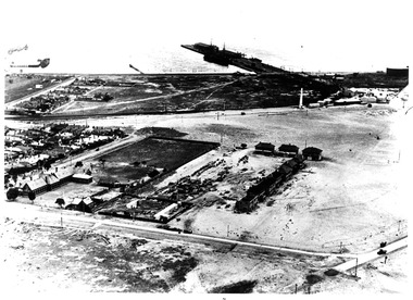
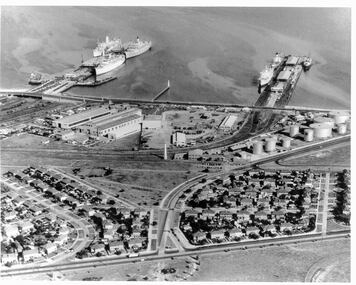
Photograph - Aerial view 1960s of Piers and surrounds
... , Williamstown Road..., Williamstown Road PIers and wharves Built Environment mission to seamen ...Gives a good overview of this area of Port Melbourne at a point in time. Identifiable objects are Station and Princes piers; Centenary Bridge; Commonwealth Government Marine Engine works; Beacons; Bank Houses; Commonwealth Oil fuel storage tanks; Missions to Seamen; Trugo club; Railway yards; Beacon Rad, Williamstown RoadPort Melbourne piers and surrounds. Aerial photo from the 1960spiers and wharves, built environment, mission to seamen, beacon -
Port Melbourne Historical & Preservation Society
Poster, History of a Street Precinct
... of the history of the area bounded by Williamstown Road and Evans, Bridge... of the history of the area bounded by Williamstown Road and Evans, Bridge ...A cultural grant was given to Margaret BRIDE to implement this study, which she did with the help of her husband Graham and several residents of the study area including PMH&PS members Emily LOCK, David THOMPSON, Jack BOLT and Kerrie MATHEE.History of a Street Precinct, documenting 80 years plus of the history of the area bounded by Williamstown Road and Evans, Bridge and Farrell Streets, since 1880. One of two products of a 2005 project (which subsequently won the 2007 Victorian Local History Award for research). A brochure containing a map of the area and photos and information on key properties. An interactive CD (2148.02) containing information and photographs on 91 buildings and their occupants over time was also produced. built environment -
Port Melbourne Historical & Preservation Society
Mixed media, History of a Street Precinct
... of the history of the area bounded by Williamstown Road and Evans, Bridge... of the history of the area bounded by Williamstown Road and Evans, Bridge ...A cultural grant was given to Margaret BRIDE to implement this study, which she did with the help of her husband Graham and several residents of the study area including PMH&PS members Emily LOCK, David THOMPSON, Jack BOLT and Kerrie MATHEE.History of a Street Precinct, documenting 80 years plus of the history of the area bounded by Williamstown Road and Evans, Bridge and Farrell Streets, since 1880. One of two products of a 2005 project (which subsequently won the 2007 Victorian Local History Awards for research). An interactive CD containing information and photographs. This was packaged with a brochure (2148.01) containing a map of the area and photos and information on key properties and individuals on 91 buildings and their occupants over time.built environment -
 Port Melbourne Historical & Preservation Society
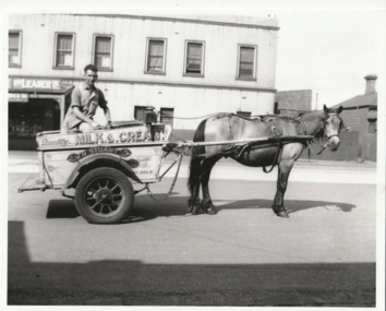
Photograph - William Raeburn STUART on milk float with horse, 'Goatie', Bridge Street, near Ross Street, Port Melbourne, 1930s
... and Williamstown Road. The newsagent and Milk Bar on the corner of Ross... Diary on the corner of Bridge street and Williamstown Road ...'Goatie' was William STUART first horse. William's parents owned the Gladysdale Diary on the corner of Bridge street and Williamstown Road. The newsagent and Milk Bar on the corner of Ross & Bridge Street is still in operation (2024). The Photo was printed from a 620 box Brownie-size negative which was found in a box of negatives taken by the late Mrs M F StuartPhoto of William Raeburn STUART on his two wheeled milk float with horse 'Goatie' standing in Bridge Street near Ross Street, late 1930s-early 40s. In background is the newsagent/milk barbusiness and traders - dairies, transport - horse, william raeburn stuart, gladysdale dairy, business and traders - milkbars, bridge street, ross street, mrs m f stuart -
 Melbourne Tram Museum
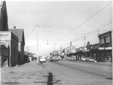
Photograph - Footscray - Victoria St - tram 678, Jim Seletto, c1960
... in Victoria St Footscray/Seddon on its way to Williamstown Road... in Victoria St Footscray/Seddon on its way to Williamstown Road ...The photograph shows MMTB X2 class tram No 678, southbound in Victoria St Footscray/Seddon on its way to Williamstown Road terminus at the corner with Walter St. On the left side is the Victoria St Methodist church. On the right is a shopping centre with signs for The Sun, The Herald, Keily, Solite floor, and Glen Valley tea. See item 8215 for a photo of X1 in the same street.Yields information about the trams in Victoria St Footscray / Seddon c1960.Black and White photograph with photographer's notes on rear"J Seletto photo"trams, x2 class, tram 678, victoria st, footscray