Showing 67 items
matching 1974 floods
-
 National Communication Museum
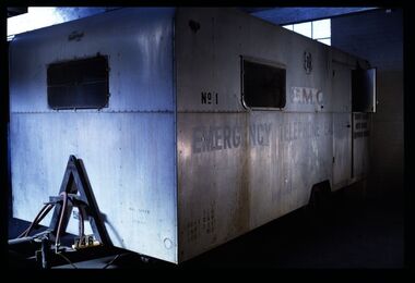
Vehicle - Mobile Telephone Exchange, c. 1965
Manufactured in the 1960s, this mobile emergency telephone exchange was fitted into a caravan. Part of the Shepparton Division State Disaster Plan, the caravan could be towed to areas affected by disasters to enable communications to recommence. The caravan remained in service until approximately 1974.Mobile infrastructure plays an important role in Australian communications, owing to the often remote and hostile environments in which Australians live and work. Exchanges such as this facilitated phone calls in the aftermath of an emergency, particularly for hospitals, police and other emergency services. Today, Mobile Exchange on Wheels (MEOWs), Cell on Wheels (CoW) and Satellite Cell on Wheels (SatCOW) - which provide temporary landline and broadband services, mobile phone coverage and service in areas without communications infrastructure respectively - are a critical part of emergency response procedures for natural disasters such as fire and flood. Though technology has progressed, the need for rapid service in remote areas remains a present concern of the communications service providers in Australia. This mobile service infrastructure is historically significant as an early example of a service which has evolved over decades, yet is still needed today. The exchange, as a representative example of a vehicle which would provide early-response in a disaster, is socially significant as a facilitator of critical communications needs in devastated communities: access to emergency services and contact with family and friends. The exchange itself, intact from its period of use, provides an insight into technology of the 1970s.Mobile emergency exchange housed in a caravan trailer on 2 wheel base, duralin body, steel tow bar, Caravan divided into 3 sections; the exchange room; the relay room and the main frame room. The exchange room contains 3 switchboards, a folding table, cupboards, benches and switch rack (.1). table (.2), steel bar for attaching the table (.3), back boards of switchboards (.4-.6), switches (.7-.16), box of switches (.17). There is a wall phone magneto, 300 type handset on wall and 2 skylights with wire screens. .11? hat pegs and shelf; there are 2 fluorescent tubes for lighting, all in exchange section. The floor is covered with 2 tone grey tiles and there are wire mesh on outside of windows and a geometric curtain inside behind switch rack. There is a flywire screen door as well as exterior door. The relay room has a sectioned door so half can open at a time. Room contains a cupboard with folding bench top beneath a curtained window. The opposite wall has a bank of batteries and transmission condensers; there is a shelf above window, one fluorescent tube and fuse boxes. Tiles on floor also. The main frame room contains many metres of coiled black covered cable, a black covered magneto wall telephone with 300 type handset; grey plastic jumper cords, a rack of termination points and wire with wasp nests attached. There is a small iron step under door, a fluorescent tube on wall and 3 hat hooks. Roll of Paper Handtowels (.18), cord and handle (.19), red exchange cords and plugs (.20-.22), plastic aluminium runners (.23,.24), headset (.25,.26), logbook (.27), battery readings (.28), box containing papers circuit drawings etc (.29-.93), paper lists off wall (.94,.95). Books, record books etc (.96-.103). Manila folder (.104) containing circuit drawings (105-.124). Wooden drawer (.125), metal drawer containing subscribers master cards, record of faults cards, particular switchboards connected, Junction line cards (.126). Box of valves (.127), box of clamps (.128). Box of 2000 type rack fuses, red 1 1/2 AMPS, black 3 AMP, blue 1/2 AMP (.129). Box of sleeves for covering wire joints (.130), plastic beakers (.131,.132), soap (.133), box of white plastic squares (.134), time switch "Venner BF/43 time switch" Made in England (.135), box of bolts, knobs etc (.136), box of switchboard number indicators (.137), fuse (.138), fuse wire (.139), football card (.140). Box of cartridge fuse 6 AMP (.141). Envelope of drawing pins, rubber bands (.142), black plastic, paper tape centres (.143-.152), metal plug (.153), 2 signs "Beware of vehicles" (.154-.155). Paper listing Naringal East automatic conversion (.156). Green Commonwealth of Australia note pad (.157). Wiring plug for tail lights (.158). Black fuse plugs (.159,.160). Box of bolts (.161). 2 sections of blue plastic coated wires (.162,.163). Gloves used for working on batteries (.164-.167). Wasp nests (.168,.169). White fuse (.170). Photographs of van in use (.171,.172)..1 on front: "ANOTHER / MOBILETRAIL / PRODUCT" "MAX SPEED / 25MPH" "TRAILER BRAKES / --- / " On sides: "EMERGENCY TELEPHONE EXCHANGE" "NO 1" "PMG" "TCQ / GROSS 250 / TARE 182 / LOAD 162" "6" "COUNTRY BRANCH / NORTH REGION / [SHEPPARTON DIVISION]" "LAW'S SIGNS" "Telecom Australia" On back: "DANGER / LONG LOAD" "MQA 3787" .133: "FIR OIL" "AUSTRALIA"mobile telephone exchanges, mobile telecommunications trailers, trailers, transport, natural disaster, black saturday, bushfires, floods, emergency communications -
 City of Kingston
Photograph - Colour, 29 January 1993
Bonbeach, Carrum and Patterson Lakes are suburbs in the City of Kingston. Bonbeach and Carrum were holiday destinations in early 20th century and over time the housing has converted to permanent residential structures. In Patterson Lakes, the area consists predominantly of newer housing developments and the tidal canal system which is accessible to many dwellings joins Port Phillip Bay.Bonbeach, Carrum and Patterson Lakes were previously part of the extensive Carrum Carrum Swamp. The area was once a source of fish and eels for the Mayone-Bulluk clan of the Bunurong people. Over time the area was drained and this allowed farming at Carrum and Bonbeach, although the area was prone to flooding. In the early 1920s and 30s the land was converted to residential dwellings. In 1973 investigations commenced nearby to Bonbeach and Carrum into the development of a unique residential area comprising canals and waterways. It was originally proposed to be known as "Gladesville". Circa 1974, the area was rezoned from rural to residential and named Patterson Lakes. Development has been continuous since the 1970s with staged construction of the waterways, residential housing, and supporting infrastructure and facilities.Laminated colour aerial photograph of the Bonbeach, Carrum and Patterson Lakes region within City of Kingston. This 1993 image includes Bonbeach High School prior to demolition, Bonbeach Primary School and Patterson River Golf Club. Sections of Patterson Lakes are not yet developed, including Rhode and Staten Islands. Long Island Point appears to be a recent development with many spare blocks and new houses under construction. The Patterson River marina is prominent and the river mouth as it meets Port Phillip Bay. The Carrum railway station is visible.Black type on white adhesive sticker: No. 6661 Black type on white adhesive sticker: 26E/6661, 29/1/93, 4.25 pm Black type on white adhesive sticker 29-1-93 Yellow circular adhesive stickerbonbeach, carrum, patterson lakes, patterson river, carrum carrum swamp, canals and waterways -
City of Moorabbin Historical Society (Operating the Box Cottage Museum)
Newsletter - CMHS Moorabbin Mirror Issue 13 February 2018, CMHS Moorabbin Mirror Newsletter Issue 13 February 2018, 2018
This is Issue 13 of the Moorabbin Mirror produced by CMHS members Fran & Holger Bader , Geoffrey Paterson, February 2018 The Moorabbin Mirror reflects the history and heritage of the former City of Moorabbin — derived from Mooroobin, ‘a resting place’ in the Bunurrung spoken language. In 1994, the City of Moorabbin was integrated into the Cities of Bayside, Glen Eira, Kingston and Monash. Topics: Vale Mr Laurie Lewis; Street Names Files; KCC Tribute for Dr G Whitehead 20years ; Local heritage 'What House is that?'; Sands & McDougal 1860-1974 digitized by State Library Vic.;Alan Clarke donated in 2016 handwritten S&M copies of residents ; 1818 1st Australia Day Gvnr. Lachlan Macquarie;1858 Foundation Stone St Patrick's Cathedral laid by Bishop J.A. Goold; 1882 Assassination attempt on A/Bishop Goold in Brighton; 1948 UN Declaration of Human Rights; Census Victoria 2016 results; Plateways by Phil Rickard Light Rail HS;Flooding at BCM Dec./Jan. ; August Rietman Exhibition Report & Photos; This is Issue 13 of the Moorabbin Mirror, Newsletter of CMHS February 2018A4 x 3 paper folded to A5 x 6pp printed both sides with colour photographs. Moorabbin / Mirror / Newsletter City of Moorabbin Historical Society Inc. A0020543 (CMHS) / operating Box Cottage Museum (BCM) / ISSUE 13 FEBRUARY 2018moorabbin mirror, bader fran, bader holger, patterson geoffrey, lewis laurie;street name files; whitehead dr g.; sands and mcdougal; clark a; archbishop gool j.a.; st. patrick's cathedral melbourne; governor macquarie l.; plateways; rickard phil.; ohm 2017; reitman august, rietman stefanie; rietman william; lone digger memorials wwi; -
Bendigo Historical Society Inc.
Photograph - AUSTIN COLLECTION: Ray Beer, Central Deborah Gold Mine
Ray Beer was an employee of the Central Deborah Gold Mine. February 15th 2009: Bendigo Advertiser: 'MINING stalwart Raymond Beer has died at the age of 74 after a battle with cancer. He leaves behind an extended family and a legacy in Bendigo’s mining history. Ray was mine manager at the Central Deborah Gold Mine - appointed in 1978 - and led the team that made possible the underground project at the second level. He had a vision to allow visitors to go underground and experience Bendigo’s mining heritage first hand. Ray was responsible for developing the new battery, shaft and poppet head to make this a reality. It took persistence and lots of hard work. Friend and work colleague Bill McNamara said Ray was as good as 10 men. His enthusiasm and work ethic were unprecedented. Ray will be sadly missed by his wife, Thelma, six children, 15 grandchildren, seven brothers, three sisters, his extended family, and friends. He will be remembered for his kindness, tenacity and strength of character. In recognition of his contribution to Bendigo’s mining history, after more than 20 years of service at his retirement, a bronze life-sized statue was unveiled in his honour'. Central Deborah Gold Mine history: At its peak, Central Deborah Gold Mine reached a depth of 412 metres. It has 17 separate levels and 15 kilometres of drives and cross cuts (tunnels). The Central Deborah was very much a hands-on mine and the conditions that the miners worked in would be considered shocking by today's standards – being lowered underground in a cage with only two sides, often working ankle to knee deep in water, filling up to 32 ore trucks a shift by hand which were then pushed a mile or more along rails in the drives, working by carbide lamp, breathing in the fumes and rock dust and communication by bells. Geez, they were ironmen. However, at the time working conditions were considered to be among the best on the goldfields at Central Deborah, after all it was one of the only mines that had hot showers. Following Central Deborah Gold Mine's closure, the Bendigo skyline began to noticeably change. Obvious remnants of mining such as poppet heads, engine rooms, service quarters, battery houses and chimneys were steadily disappearing. After intense lobbying by the local community, the Bendigo City Council purchased the still very much intact Central Deborah Gold Mine in 1970 for a mere $6,000 to ensure that a vital link to Bendigo's historic golden past was maintained. The Bendigo Trust was then formed to oversee the operations of the Central Deborah Gold Mine, which led to the surface of the mine being opened to the public in 1971. Initially the surface was open for just 12 hours a week and as the demand for viewing a part of Bendigo's history increased, so did the opening hours. In 1974 the mine was gazetted as a Public Historical Purposes Reserve and attracted such visitors as H.R.H Prince Charles. By far the greatest shortcoming at this stage was that no one could view the underground workings, as these had become flooded. After what could only be described as a monumental effort by everyone involved, Level 2 of the mine was officially opened to the public by the Premier of Victoria, the Honourable John Cain, on 20 June 1986, which brought to fruition a long standing dream.Black and white photograph. Ray Beer, underground at Central Deborah Gold Mine, standing alongside wooden sign 'Murrell's Corner'. Sign is placed horizontally on timber supports; side of drive visible in background. Ray is wearing bib and brace overalls and hard hat with a belt around his waist. He is giving a 'thumbs up' sign. gold mining, central deborah gold mine, ray beer, mine manager -
Bendigo Historical Society Inc.
Photograph - AUSTIN COLLECTION: Central Deborah Gold Mine Lift Shaft
Central Deborah Gold Mine history: At its peak, Central Deborah Gold Mine reached a depth of 412 metres. It has 17 separate levels and 15 kilometres of drives and cross cuts (tunnels). The Central Deborah was very much a hands-on mine and the conditions that the miners worked in would be considered shocking by today's standards – being lowered underground in a cage with only two sides, often working ankle to knee deep in water, filling up to 32 ore trucks a shift by hand which were then pushed a mile or more along rails in the drives, working by carbide lamp, breathing in the fumes and rock dust and communication by bells. Geez, they were ironmen. However, at the time working conditions were considered to be among the best on the goldfields at Central Deborah, after all it was one of the only mines that had hot showers. Following Central Deborah Gold Mine's closure, the Bendigo skyline began to noticeably change. Obvious remnants of mining such as poppet heads, engine rooms, service quarters, battery houses and chimneys were steadily disappearing. After intense lobbying by the local community, the Bendigo City Council purchased the still very much intact Central Deborah Gold Mine in 1970 for a mere $6,000 to ensure that a vital link to Bendigo's historic golden past was maintained. The Bendigo Trust was then formed to oversee the operations of the Central Deborah Gold Mine, which led to the surface of the mine being opened to the public in 1971. Initially the surface was open for just 12 hours a week and as the demand for viewing a part of Bendigo's history increased, so did the opening hours. In 1974 the mine was gazetted as a Public Historical Purposes Reserve and attracted such visitors as H.R.H Prince Charles. By far the greatest shortcoming at this stage was that no one could view the underground workings, as these had become flooded. After what could only be described as a monumental effort by everyone involved, Level 2 of the mine was officially opened to the public by the Premier of Victoria, the Honourable John Cain, on 20 June 1986, which brought to fruition a long standing dream.Black and white photograph, looking from bottom of lift shaft towards the surface; light visible at top of shaft. Lift cables and safety mesh on sides of shaft. gold mining, central deborah gold mine, ray beer, mine manager -
Bendigo Historical Society Inc.
Photograph - AUSTIN COLLECTION: Central Deborah Gold Mine, Possibly 1990's
Central Deborah Gold Mine history: At its peak, Central Deborah Gold Mine reached a depth of 412 metres. It has 17 separate levels and 15 kilometres of drives and cross cuts (tunnels). The Central Deborah was very much a hands-on mine and the conditions that the miners worked in would be considered shocking by today's standards – being lowered underground in a cage with only two sides, often working ankle to knee deep in water, filling up to 32 ore trucks a shift by hand which were then pushed a mile or more along rails in the drives, working by carbide lamp, breathing in the fumes and rock dust and communication by bells. Geez, they were ironmen. However, at the time working conditions were considered to be among the best on the goldfields at Central Deborah, after all it was one of the only mines that had hot showers. Following Central Deborah Gold Mine's closure, the Bendigo skyline began to noticeably change. Obvious remnants of mining such as poppet heads, engine rooms, service quarters, battery houses and chimneys were steadily disappearing. After intense lobbying by the local community, the Bendigo City Council purchased the still very much intact Central Deborah Gold Mine in 1970 for a mere $6,000 to ensure that a vital link to Bendigo's historic golden past was maintained. The Bendigo Trust was then formed to oversee the operations of the Central Deborah Gold Mine, which led to the surface of the mine being opened to the public in 1971. Initially the surface was open for just 12 hours a week and as the demand for viewing a part of Bendigo's history increased, so did the opening hours. In 1974 the mine was gazetted as a Public Historical Purposes Reserve and attracted such visitors as H.R.H Prince Charles. By far the greatest shortcoming at this stage was that no one could view the underground workings, as these had become flooded. After what could only be described as a monumental effort by everyone involved, Level 2 of the mine was officially opened to the public by the Premier of Victoria, the Honourable John Cain, on 20 June 1986, which brought to fruition a long standing dream.Black and white photograph. Two men with hard hats and lights, inspecting quartz outcrop on wall of drive at Central Deborah Gold Mine.gold mining, central deborah gold mine, ray beer, mine manager -
Bendigo Historical Society Inc.
Photograph - AUSTIN COLLECTION: Operating rock drill, Central Deborah Gold Mine, Possibly 1990's
Central Deborah Gold Mine history: At its peak, Central Deborah Gold Mine reached a depth of 412 metres. It has 17 separate levels and 15 kilometres of drives and cross cuts (tunnels). The Central Deborah was very much a hands-on mine and the conditions that the miners worked in would be considered shocking by today's standards – being lowered underground in a cage with only two sides, often working ankle to knee deep in water, filling up to 32 ore trucks a shift by hand which were then pushed a mile or more along rails in the drives, working by carbide lamp, breathing in the fumes and rock dust and communication by bells. Geez, they were ironmen. However, at the time working conditions were considered to be among the best on the goldfields at Central Deborah, after all it was one of the only mines that had hot showers. Following Central Deborah Gold Mine's closure, the Bendigo skyline began to noticeably change. Obvious remnants of mining such as poppet heads, engine rooms, service quarters, battery houses and chimneys were steadily disappearing. After intense lobbying by the local community, the Bendigo City Council purchased the still very much intact Central Deborah Gold Mine in 1970 for a mere $6,000 to ensure that a vital link to Bendigo's historic golden past was maintained. The Bendigo Trust was then formed to oversee the operations of the Central Deborah Gold Mine, which led to the surface of the mine being opened to the public in 1971. Initially the surface was open for just 12 hours a week and as the demand for viewing a part of Bendigo's history increased, so did the opening hours. In 1974 the mine was gazetted as a Public Historical Purposes Reserve and attracted such visitors as H.R.H Prince Charles. By far the greatest shortcoming at this stage was that no one could view the underground workings, as these had become flooded. After what could only be described as a monumental effort by everyone involved, Level 2 of the mine was officially opened to the public by the Premier of Victoria, the Honourable John Cain, on 20 June 1986, which brought to fruition a long standing dream.Black and white photograph. Two men with hard hats and lights standing in front of underground rock surface at Central Deborah Gold Mine. Man on left hand side of image is operating a small rock drill. Man on right hand side is observing the procedure. gold mining, central deborah gold mine, rock drill, underground