Showing 1533 items
matching aerial photograph
-
 Greensborough Historical Society
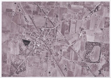
Aerial Photograph, Watsonia, Greensborough, 1945c
... Aerial Photograph...Black and white aerial photograph... aerial photograph Watsonia, Greensborough Aerial Photograph ...Covers Greensborough, Watsonia and Macleod areasBlack and white aerial photographgreensborough, watsonia, macleod -
 Rutherglen Historical Society
Map - Photocopy of an aerial photograph
... Photocopy of an aerial photograph...Photocopy of an aerial photograph of Rutherglen...-country aerial photographs rutherglen Photocopy of an aerial ...Photocopy of an aerial photograph of Rutherglenaerial photographs, rutherglen -
 Kew Historical Society Inc
Photograph, Department of Property & Services (Victoria), City of Kew No.2/6, 12/12/1987
... aerial photograph - kew...One of a series of six small square black and white aerial...Aerial photograph of a part of Kew, taken by photographers... of a series of six small square black and white aerial photographs ...One of a series of six small square black and white aerial photographs of Kew taken and produced by the Victorian Department of Property Services.Aerial photographs, of which the Society has a number in its collection, allow researchers to identify changes in urban infrastructure and demographics over timeAerial photograph of a part of Kew, taken by photographers employed by the Victorian Department of Property and Services in December 1987.aerial photograph - kew -
 Kew Historical Society Inc
Photograph, Department of Property & Services (Victoria), City of Kew No.3/6, 12/12/1987
... aerial photograph - kew...One of a series of six small square black and white aerial...Aerial photograph of a part of Kew, taken by photographers... of a series of six small square black and white aerial photographs ...One of a series of six small square black and white aerial photographs of Kew taken and produced by the Victorian Department of Property Services.Aerial photographs, of which the Society has a number in its collection, allow researchers to identify changes in urban infrastructure and demographics over timeAerial photograph of a part of Kew, taken by photographers employed by the Victorian Department of Property and Services in December 1987.aerial photograph - kew, aerial photographs -
 Kew Historical Society Inc
Photograph, Department of Property & Services (Victoria), City of Kew No.4/6, 12/12/1987
... aerial photograph - kew...One of a series of six small square black and white aerial...Aerial photograph of a part of Kew, taken by photographers... of a series of six small square black and white aerial photographs ...One of a series of six small square black and white aerial photographs of Kew taken and produced by the Victorian Department of Property Services.Aerial photographs, of which the Society has a number in its collection, allow researchers to identify changes in urban infrastructure and demographics over timeAerial photograph of a part of Kew, taken by photographers employed by the Victorian Department of Property and Services in December 1987.aerial photograph - kew, aerial photographs -
 Kew Historical Society Inc
Photograph, Department of Property & Services (Victoria), City of Kew, No.5/6, 12/12/1987
... aerial photograph - kew...One of a series of six small square black and white aerial...Aerial photograph of a part of Kew, taken by photographers... of a series of six small square black and white aerial photographs ...One of a series of six small square black and white aerial photographs of Kew taken and produced by the Victorian Department of Property Services.Aerial photographs, of which the Society has a number in its collection, allow researchers to identify changes in urban infrastructure and demographics over timeAerial photograph of a part of Kew, taken by photographers employed by the Victorian Department of Property and Services in December 1987.aerial photograph - kew, aerial photographs -
 Kew Historical Society Inc
Photograph, Department of Property & Services (Victoria), City of Kew, No.6/6, 12/12/1987
... aerial photograph - kew...One of a series of six small square black and white aerial...Aerial photograph of a part of Kew, taken by photographers... of a series of six small square black and white aerial photographs ...One of a series of six small square black and white aerial photographs of Kew taken and produced by the Victorian Department of Property Services.Aerial photographs, of which the Society has a number in its collection, allow researchers to identify changes in urban infrastructure and demographics over timeAerial photograph of a part of Kew, taken by photographers employed by the Victorian Department of Property and Services in December 1987.4312-108 Ringwood M'Sheet 7922-3 Run 4 5600'ASL Vic DPS © 12-12-87aerial photograph - kew, aerial photographs -
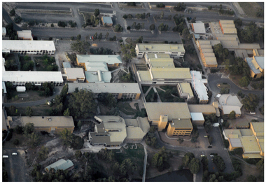
 Federation University Historical Collection
Photograph - Aerial Photograph, Federation University Mount Helen Campus, 06/08/2013
... Aerial Photograph...aerial photograph... buildings Mount Helen campus aerial photograph Colour photograph ...Colour photograph of Federation University Mount Helen Campusbuildings, mount helen campus, aerial photograph -
 Federation University Historical Collection
Photograph - Aerial Photograph, Federation University SMB Campus, 06/08/2013
... Aerial Photograph...aerial photograph... buildings aerial photograph SMB Campus Ballarat Club Uniting Church ...Colour photograph of Federation University SMB Campusbuildings, aerial photograph, smb campus, ballarat club, uniting church -
 Federation University Historical Collection
Photograph - Aerial Photograph, Federation University Arts Academy Campus, 06/08/2013
... Aerial Photograph...aerial photograph... buildings aerial photograph ballarat club Arts Academy camp Street ...Colour photograph of Federation University Arts Academy Campusbuildings, aerial photograph, ballarat club, arts academy, camp street campus, ballarat trades hall, former ballarat state officers, art gallery of ballarat, old colonists' hall, ballarat mining exchange -
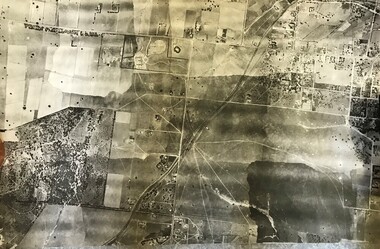
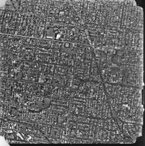
 Greensborough Historical Society
Aerial Photograph, Flintoff land - View from above, 1945_
... Aerial Photograph...aerial photograph... family flintoff family aerial photograph "Flintoff land to west ...Section of the 1945 Greensborough aerial survey, focusing on the land belonging to the Flintoff familyPhotocopy of section of 1945 aerial survey of Greensborough area"Flintoff land to west of Diamond Creek Rd" written in pencil on backflintoff family, aerial photograph -
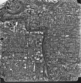
 Greensborough Historical Society
Aerial Photograph, Watsonia and Rosanna, 1945c
... Aerial Photograph...Black and white aerial photograph (copy of section)... aerial photograph (copy of section) Watsonia and Rosanna Aerial ...Covers Yallambie (Simpson Barracks) and Macleod areasBlack and white aerial photograph (copy of section)yallambie, macleod, simpson barracks -
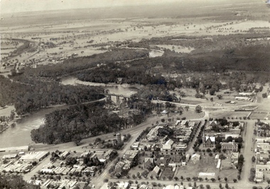 Echuca Historical Society
Aerial photograph Echuca 1927
... Aerial photograph Echuca 1927...Aerial photograph (scanned) 1927 Note open spaces...-country Aerial photograph (scanned) 1927 Note open spaces Aerial ...Aerial photograph (scanned) 1927 Note open spaces -
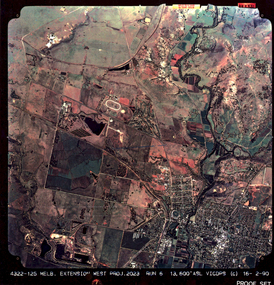 Federation University Historical Collection
colored aerial photograph, Melb. Extension West Project, 2023
... colored aerial photograph...13323.1, 13323.2, 13323.3 colored typographical aerial... colored typographical aerial photographs, encapsulated Melb ...13323.1, 13323.2, 13323.3 colored typographical aerial photographs, encapsulatedprinted "Melb. Extension West Proj. 2023..." -
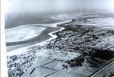
 Queenscliffe Maritime Museum
Photograph - Aerial photograph of Queenscliff and Swan Island 1960s
... Aerial photograph of Queenscliff and Swan Island 1960s...Aerial photograph on cardboard depicting Queenscliff...-and-the-bellarine-peninsula Aerial photograph on cardboard depicting ...Aerial photograph on cardboard depicting Queenscliff and Swan Island C1960s -
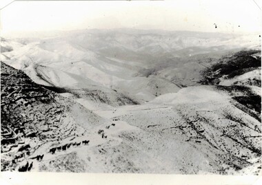 8th/13th Victorian Mounted Rifles Regimental Collection
Photograph - Aerial photograph desert column
... Aerial photograph desert column...Black and White aerial photograph of column of horses... aerial photograph of column of horses in desert terrain ...Example of aerial photography during WWI in Middle East.Black and White aerial photograph of column of horses in desert terrainmilitary, wwi, world war one, desert, horses, aerial -
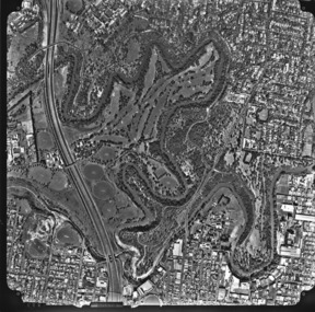
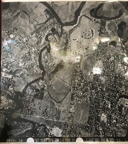 Greensborough Historical Society
Aerial Photograph, Yan Yean M/S 7922 Run 17 No. 3833-18, 1/11/1984
... Aerial Photograph...Laminated black and white aerial photograph; adjoins 6227... and white aerial photograph; adjoins 6227 on west side Yan Yean M/S ...Covers Viewbank area: North boundary Martin's Lane; South boundary Yarra River & Birrarung Park; East boundary east of Plenty RiverLaminated black and white aerial photograph; adjoins 6227 on west sideviewbank -
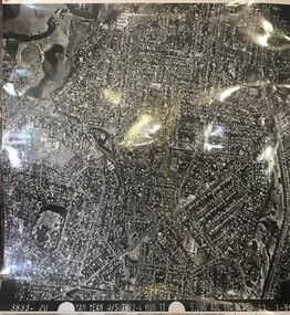 Greensborough Historical Society
Aerial Photograph, Yan Yean M/S 7922 Run 17 No. 3833-20, 01/11/1984
... Aerial Photograph...Laminated black and white aerial photograph; adjoins 6226... and white aerial photograph; adjoins 6226 on east side Yan Yean M/S ...Covers Rosanna and parts of Viewbank and Heidelberg. East boundary Price Park; West boundary Hurstbridge railway lineLaminated black and white aerial photograph; adjoins 6226 on east siderosanna, viewbank, heidelberg -
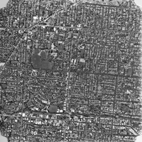
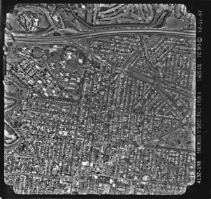
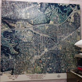 Kew Historical Society Inc
Photograph - Aerial Photograph, Division of Survey and Mapping, Department of Property and Services, City of Kew, Scale 1 : 3,000, 1989, 1989
... Aerial Photograph...Very large aerial photograph of “City of Kew” Scale 1...) Copyright 1990. Very large aerial photograph of “City of Kew” Scale ...The City of Kew was a local government area about 4 kilometres east of Melbourne, the state capital of Victoria, Australia, on the southeast bank of the Yarra River. The city covered an area of 14.56 square kilometres, and existed from 1860 until 1994.Very large aerial photograph of “City of Kew” Scale 1 : 3,000. 1989. “City of Kew” Scale 1 : 3,000. 1989. Photomosaic compiled by Division of Survey and Mapping, Department of Property and Services. © Crown (State of Victoria) Copyright 1990.city of kew, kew (vic.), aerial photography -
 Federation University Historical Collection
Photograph, Ballarat Aerial Photograph
... Ballarat Aerial Photograph... Ballarat Aerial Photograph Photograph ... -
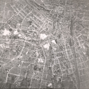
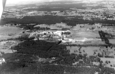
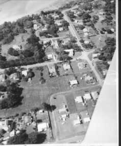
 Ringwood and District Historical Society
Photograph, Aerial photograph of Heathmont, Victoria - c.1960s, 1975
... Aerial photograph of Heathmont, Victoria - c.1960s..... Aerial view of Heathmont - black and white photograph ...Aerial view of Heathmont - black and white photograph on chipboard backing. (Protected by slightly damaged plastic cover which could be removed for clearer image.)Department of Crown Lands and Survey Melbourne, Project Run 31A 27-12-1975, Lens 209 1951M ASL. -
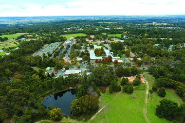
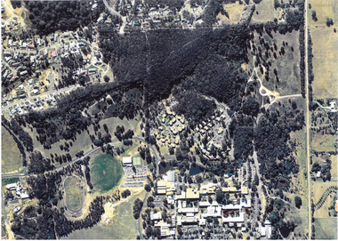
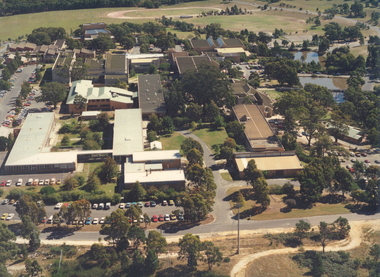 Federation University Historical Collection
Photograph, Aerial Photograph of Federation University Mount Helen campus looking towards the oval, 1991, 1991
... Aerial Photograph of Federation University Mount Helen... of Federation University Australia, taken from above. Aerial Photograph ...The Mount Helen Campus opened to students in 1970.Laminated colour photograph of the Mount Helen Campus of Federation University Australia, taken from above. mount helen, mount helen campus, ballarat institute of advanced education, aerial, rooftop -
 Federation University Historical Collection
Photograph - Photograph - Colour, Aerial Photograph of Federation University Mount Helen Campus
... Aerial Photograph of Federation University Mount Helen...Colour photograph showing an aerial view of the Federation... university Colour photograph showing an aerial view of the Federation ...Federation University Australia was established on 1 January 2014. Formerly known as the University of Ballarat, its enabling legislation was the University of Ballarat Amendment (Federation University Australia) Act 2013. Although formally created as a University in 1994, the University of Ballarat has a lineage back to 1870 with the establishment of the School of Mines Ballarat, making it the third institution of higher learning to be established in Australia and the first to be established in regional Australia. On 1 January 1994, Ballarat University College became the University of Ballarat and in 1998 the University merged with three TAFE Institutes to become a dual sector institution with multiple campuses. On 1 January 2014, the University of Ballarat amalgamated with the Monash University Gippsland Campus to form Federation University Australia. The Gippsland Campus also had a long lineage dating back to 1928 with the establishment of the Yallourn Technical School which became a predecessor institution to the Gippsland College of Advanced Education formed in 1968. In 1990, it was renamed the Monash University College and in 1993 became the Gippsland Campus of Monash University. In 2016, Federation University Australia announced plans to take possession, over a two-year period, of Monash’s Berwick Campus in the south-east corridor of Melbourne. Federation University Australia, or FedUni, is headquartered in Ballarat and offers programs in Higher Education and Vocational Education and Training to regional Victoria and beyond. The University’s commitment to educational and social equity, teaching excellence, research distinction, environmental sustainability and regional capacity building has enabled it to develop in a way that draws on its proud heritage to inform its future. Its regional character sets a framework for the University’s priorities but does not constrain it from serving wider community interests, nationally and internationally. The name Federation University Australia was chosen to convey the scope and capacity of an expanded regional university with a federated network of campuses.Colour photograph showing an aerial view of the Federation University Mount Helen Campus.aerial, mount helen campus, federation university -
 Federation University Historical Collection
Photograph - Photograph - Black and White, Aerial Photograph of Federation University Mount Helen Campus
... Aerial Photograph of Federation University Mount Helen... University Mount Helen Campus. Aerial Photograph of Federation ...Federation University Australia was established on 1 January 2014. Formerly known as the University of Ballarat, its enabling legislation was the University of Ballarat Amendment (Federation University Australia) Act 2013. Although formally created as a University in 1994, the University of Ballarat has a lineage back to 1870 with the establishment of the School of Mines Ballarat, making it the third institution of higher learning to be established in Australia and the first to be established in regional Australia. On 1 January 1994, Ballarat University College became the University of Ballarat and in 1998 the University merged with three TAFE Institutes to become a dual sector institution with multiple campuses. On 1 January 2014, the University of Ballarat amalgamated with the Monash University Gippsland Campus to form Federation University Australia. The Gippsland Campus also had a long lineage dating back to 1928 with the establishment of the Yallourn Technical School which became a predecessor institution to the Gippsland College of Advanced Education formed in 1968. In 1990, it was renamed the Monash University College and in 1993 became the Gippsland Campus of Monash University. In 2016, Federation University Australia announced plans to take possession, over a two-year period, of Monash’s Berwick Campus in the south-east corridor of Melbourne. Federation University Australia, or FedUni, is headquartered in Ballarat and offers programs in Higher Education and Vocational Education and Training to regional Victoria and beyond. The University’s commitment to educational and social equity, teaching excellence, research distinction, environmental sustainability and regional capacity building has enabled it to develop in a way that draws on its proud heritage to inform its future. Its regional character sets a framework for the University’s priorities but does not constrain it from serving wider community interests, nationally and internationally. The name Federation University Australia was chosen to convey the scope and capacity of an expanded regional university with a federated network of campuses.Colour photograph showing an aereal view of the Federation University Mount Helen Campus.aerial, mount helen campus, federation university -
 Federation University Historical Collection
Photograph - Colour, Aerial Photograph of Federation University Mount Helen Campus, c2010
... Aerial Photograph of Federation University Mount Helen... University Mount Helen Campus. Aerial Photograph of Federation ...Federation University Australia was established on 1 January 2014. Formerly known as the University of Ballarat, its enabling legislation was the University of Ballarat Amendment (Federation University Australia) Act 2013. Although formally created as a University in 1994, the University of Ballarat has a lineage back to 1870 with the establishment of the School of Mines Ballarat, making it the third institution of higher learning to be established in Australia and the first to be established in regional Australia. On 1 January 1994, Ballarat University College became the University of Ballarat and in 1998 the University merged with three TAFE Institutes to become a dual sector institution with multiple campuses. On 1 January 2014, the University of Ballarat amalgamated with the Monash University Gippsland Campus to form Federation University Australia. The Gippsland Campus also had a long lineage dating back to 1928 with the establishment of the Yallourn Technical School which became a predecessor institution to the Gippsland College of Advanced Education formed in 1968. In 1990, it was renamed the Monash University College and in 1993 became the Gippsland Campus of Monash University. In 2016, Federation University Australia announced plans to take possession, over a two-year period, of Monash’s Berwick Campus in the south-east corridor of Melbourne. Federation University Australia, or FedUni, is headquartered in Ballarat and offers programs in Higher Education and Vocational Education and Training to regional Victoria and beyond. The University’s commitment to educational and social equity, teaching excellence, research distinction, environmental sustainability and regional capacity building has enabled it to develop in a way that draws on its proud heritage to inform its future. Its regional character sets a framework for the University’s priorities but does not constrain it from serving wider community interests, nationally and internationally. The name Federation University Australia was chosen to convey the scope and capacity of an expanded regional university with a federated network of campuses.Colour photograph showing an aereal view of the Federation University Mount Helen Campus.aerial, mount helen campus, federation university -
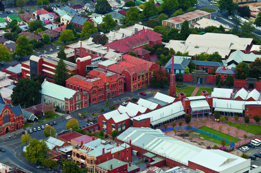
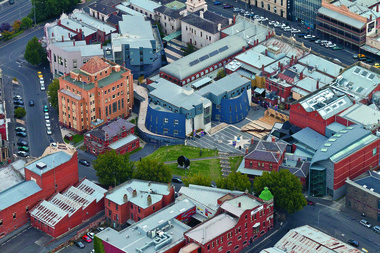
 Federation University Historical Collection
Photograph - Colour, Aerial Photograph of an area of Ballarat
... Aerial Photograph of an area of Ballarat... of Ballarat Aerial Photograph of an area of Ballarat Photograph ...Colour photograph showing an aereal view of an area of Ballarataerial, ballarat -
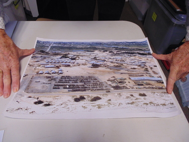 National Vietnam Veterans Museum (NVVM)
Photograph, Aerial Photograph
... Aerial Photograph... Base Aerial Photograph Photograph Photograph ...A coloured photograph taken from the aire of Vung Tau Army BasePhotograph,Vung Tau Army Base -
 Inverloch Historical Society
000146 - Photograph - Aerial Photograph - R Young
... 000146 - Photograph - Aerial Photograph - R Young...) Inverloch gippsland 000146 - Photograph - Aerial Photograph - R ... -
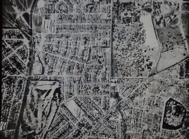
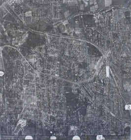
Whitehorse Historical Society Inc.
Map, Aerial photograph, c1950
... Aerial photograph... Mitcham melbourne vermont south burwood east aerial photographs ...Arial photo of Vermont South and Burwood East, Middleborough Road, Burwood Highway, Springvale Road, Highbury Road and environs.Aerial photo of Vermont South and Burwood East, Middleborough Road, Burwood Highway, Springvale Road, Highbury Road and environs.Arial photo of Vermont South and Burwood East, Middleborough Road, Burwood Highway, Springvale Road, Highbury Road and environs.vermont south, burwood east, aerial photographs -
 Inverloch Historical Society
001247 - Photograph - circa 1960's - Aerial Photograph - Inverloch from North East (looking South West) - from L Bailey
... 001247 - Photograph - circa 1960's - Aerial Photograph...) Inverloch gippsland 001247 - Photograph - circa 1960's - Aerial ...