Showing 732 items
matching aerial photos
-
 Port Melbourne Historical & Preservation Society
Photograph - Aerial view of land reclamation at Webb Dock, Port Melbourne, 1997
... Colour aerial photo showing land reclamatioon at Webb Dock... authority Colour aerial photo showing land reclamatioon at Webb Dock ...Colour aerial photo showing land reclamatioon at Webb Dock, 1997piers and wharves - webb dock, melbourne harbor trust - port of melbourne authority -
Tatura Irrigation & Wartime Camps Museum
Book, Ernestine Hill, Water Into Gold, 1965
... Blue soft cover. Depicting aerial photo of farmland. White... cover. Depicting aerial photo of farmland. White lettering Water ...Depicts pioneers of irrigation - Chaffey bros and story of irrigation on the MurrayBlue soft cover. Depicting aerial photo of farmland. White letteringirrigation, chaffey -
Tatura Irrigation & Wartime Camps Museum
Book, Water into Gold, 1965
... Blue soft cover, depicting aerial photo of farmland, white... cover, depicting aerial photo of farmland, white lettering ...Depicts pioneers of irrigation, Chaffey Bros., and story of irrigation on the Murray RiverBlue soft cover, depicting aerial photo of farmland, white lettering.water into gold, irrigation, hill e, tatura, books, history, local, rural, industry -
Stawell Historical Society Inc
Photograph, Stawell Gold Mine, Aerial Photomap of Stawell & Mining 1997, 1997
... Large Laminated Aerial Photo Map showing Stawell... 1997 Large Laminated Aerial Photo Map showing Stawell ...Evaporation Dams Mining SiteLarge Laminated Aerial Photo Map showing Stawell and Mining activityMining Geology Office 1997mining -
 Ringwood and District Historical Society
Photograph, Aerial photo of Cherrydene Estate in foreground off Oban Rd, Ringwood - c.1967
... Aerial photo of Cherrydene Estate in foreground off Oban Rd...Written on back of photograph, "Aerial photo of Cherry Dene..., "Aerial photo of Cherry Dene Estate in foreground, c1967 off Oban ...Written on back of photograph, "Aerial photo of Cherry Dene Estate in foreground, c1967 off Oban Rd." -
 Bacchus Marsh & District Historical Society
Photograph, Aerial image of Bacchus Marsh and Darley in 1994
... "Bacchus Marsh - Darley. Aerial Photo 27 November, 1994... Marsh Vic. "Bacchus Marsh - Darley. Aerial Photo 27 November ...A whole of town and nearby area aerial image of Bacchus Marsh produced for display in the Arbee Real Estate Agency premises in Main Street, Bacchus Marsh.A large framed colour aerial photograph showing the township of Bacchus Marsh, the neighbouring smaller community of Darley, and the nearby areas of both places. "Bacchus Marsh - Darley. Aerial Photo 27 November, 1994. Presented by Arbee Real Estate "Professionals"'arbee real estate agency bacchus marsh, aerial views bacchus marsh vic. -
Glenelg Shire Council Cultural Collection
Photograph - Photograph - Cape Grant Quarry, n.d
... Black and white photo. Aerial photo of Cape Grant quarry.... Aerial photo of Cape Grant quarry, from sea Photograph Photograph ...Port of Portland Authority ArchivesBack: 'JAN 24, 1968' - pencil, top rightport of portland archives, cape grant quarry -
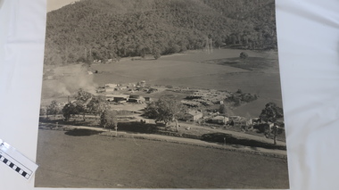 Kiewa Valley Historical Society
Photo - Tawonga Sawmill
... Black/grey and white aerial photo of the Tawonga Mill site... and white aerial photo of the Tawonga Mill site circa 1960s. Photo ...Photo of the Tawonga Sawmill at Tawonga. It was operated by Mt Beauty Timbers P/L circa 1960s. Prior to transfer to Mt Beauty site.The Mt Beauty Timber mill closed in the 1990s due to changes to government legislation regarding logging in the National Park.Black/grey and white aerial photo of the Tawonga Mill site circa 1960s.tawonga sawmill, mt beauty timbers pty ltd, logging -
 Kiewa Valley Historical Society
Photo - Aerial photo of Mt Beauty
... Photo - Aerial photo of Mt Beauty...Small sepia aerial photo of Mt Beauty taken from Big Hill... sepia aerial photo of Mt Beauty taken from Big Hill Photo ...Small sepia aerial photo of Mt Beauty taken from Big Hill -
Glenelg Shire Council Cultural Collection
Photograph - Photograph - Portland harbour, n.d
... Black and white aerial photo of Harbour and surrounds... Authority Black and white aerial photo of Harbour and surrounds ...Port of Portland Authority -
Glenelg Shire Council Cultural Collection
Photograph - Photograph - Portland Harbour, port area and Pivot fertilizer, n.d
... Black and white aerial photo of harbour and port area... Authority Black and white aerial photo of harbour and port area ...Port of Portland Authority -
Port Melbourne Historical & Preservation Society
Photograph - Aerial view of J Kitchen & Sons site, Ingles Street, Port Melbourne, 1930
... Overhead -aerial - photo of J Kitchen & Sons factories... Pty Ltd Overhead -aerial - photo of J Kitchen & Sons factories ...Overhead -aerial - photo of J Kitchen & Sons factories with Football ground at rearsport - australian rules football, sport - cricket, industry, j kitchen & sons pty ltd -
Port Melbourne Historical & Preservation Society
Photograph - Double-sided aerial photograph, Hobson's Bay and the Yarra River/Port Phillip and Western Port Bay, Surveyor General and Director of Mapping, Apr 1990
... Aerial photos of Port Phillip and Western Port (double... authority Aerial photos of Port Phillip and Western Port (double ...Landsat imagery - an extract from the atlas of VictoriaAerial photos of Port Phillip and Western Port (double sided aerial photographs). 1995 side A: Hobson's Bay and Yarra River - aerial photo mosaic; side B. Port Phillip and Western Port Bays - satellite photo.port of melbourne authority -
Glenelg Shire Council Cultural Collection
Photograph - Photograph - aerial view of Portland, n.d
... Black & white aerial photo of K.S. Anderson wharf area... Portland Harbour K S Anderson Wharf Black & white aerial photo ...Port of Portland Authority Archivesport of portland archives, aerial photography, portland harbour, k s anderson wharf -
Glenelg Shire Council Cultural Collection
Photograph - Photograph - aerial view of Portland, n.d
... Black & white aerial photo of Portland Harbour, taken from... Portland Harbour Black & white aerial photo of Portland Harbour ...Port of Portland Authority Archivesport of portland archives, aerial photography, portland harbour -
Glenelg Shire Council Cultural Collection
Photograph - Photograph - aerial view of Portland, n.d
... Black & white aerial photo of the Port of Portland... Portland Harbour Black & white aerial photo of the Port of Portland ...Port of Portland Authority Archivesport of portland archives, aerial photography, portland harbour -
Glenelg Shire Council Cultural Collection
Photograph - Photograph - Main Breakwater Construction, n.d
... Aerial Photo...Black and white aerial photo of the harbour, looking toward... breakwater construction Aerial Photo Black and white aerial photo ...Port of Portland Authority Archivesport of portland archives, portland harbour, main breakwater, construction, aerial photo -
Glenelg Shire Council Cultural Collection
Photograph - Photograph - Main Breakwater construction, Portland, 17/11/1958
... Black and white aerial photo of the harbour, looking toward... and white aerial photo of the harbour, looking toward main ...Port of Portland Authority ArchivesFront: Purplestamp- '17 Nov 1958' L81-Pencil Back: Purple stamp- '17 Nov 1958' L81 - Pencilport of portland archives, main breakwater, construction, harbour development -
Glenelg Shire Council Cultural Collection
Photograph, n.d
... Black and white aerial photo of Cape Grant quarry... Authority Archives Port of Portland Black and white aerial photo ...Port of Portland Authority Archivesport of portland -
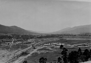
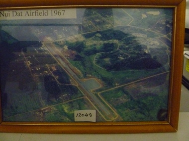 National Vietnam Veterans Museum (NVVM)
Photograph, Nui Dat Airfield 1967
... Framed coloured aerial photo of Nui Dat Airfield depicting... Photograph Nui Dat Airfield 1962 Framed coloured aerial photo of Nui ...Framed coloured aerial photo of Nui Dat Airfield depicting runway and surrounding infrastructure.Nui Dat Airfield 1962nui dat airfield, photograph -
Whitehorse Historical Society Inc.
Map, Burwood Highway, c1970
... Enlarged aerial photo of area South of Burwood Highway..., Vermont South. Enlarged aerial photo of area South of Burwood ...Enlarged aerial photo of area South of Burwood Highway to Dandenong Creek, Vermont South.Enlarged aerial photo of area South of Burwood Highway to Dandenong Creek, Vermont South.Enlarged aerial photo of area South of Burwood Highway to Dandenong Creek, Vermont South.dandenong creek, morack road, vermont south, burwood highway, vermont south, aerial photographs -
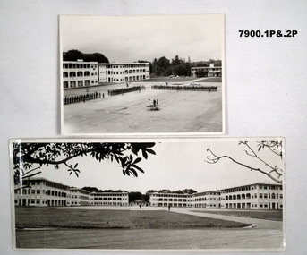 Bendigo Military Museum
Photograph - SELARANG BARRACKS, 1970
... and buildings of Selarang Base, Singapore in 1970. 3. Aerial photo.... 3. Aerial photo of Selarang Barracks from a distance. 4 ...Various photos of Selarang Barracks in Singapore in 1970. Some aerial and some ground level views. Refer items in Collection of LLoyd Farrell. Refer Cat 7889P.1. Photo of 1 RAR on parade for Trooping of the Colours in 1970 at Selarang Base in Singapore. Covering 'A' 'B' 'C' and Admin Company. 2. Extended portrait photo of the Parade Square and buildings of Selarang Base, Singapore in 1970. 3. Aerial photo of Selarang Barracks from a distance. 4. Aerial photo of Selarang Barracks 1970. 5. Aerial photo of Changi Prison 1970 in Singapore.Written on back. 1. "1 M1+" 2. “Selarang Barracks 1970 occupied by 1st RAR” 4. “Selarang 70” 5. "Changi Prison 1970 Singapore".photograhs, changi, selarang, 1970, lloyd farrell. -
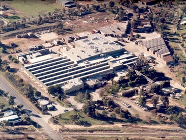 Tatura Irrigation & Wartime Camps Museum
Photograph, Rosella aerial
... Aerial photo of the Unifoods "Rosella" factory at Tatura... Tatura the-murray Aerial photo of the Unifoods "Rosella" factory ...Aerial photo of the Unifoods "Rosella" factory at Tatura, 1997.|Aerial photo of Rosella factory 1949. -
Glenelg Shire Council Cultural Collection
Photograph - Photograph - Cape Grant Quarry, 24/01/1968
... Black and white photo. Aerial photo of Cape Grant quarry.... Aerial photo of Cape Grant quarry from sea, looking north ...Port of Portland Authority ArchivesBack: 'JAN 24, 1968 ' - pencil top rightport of portland archives, cape grant quarry -
Glenelg Shire Council Cultural Collection
Photograph - Photograph - aerial view of Portland Harbour, n.d
... Black & white aerial photo of Portland Harbour, taken from... Blow to 110% -7/101 all in blue biro Black & white aerial photo ...Port of Portland Authority ArchivesBack: Harbour Broad scene P.2 Blow to 110% -7/101 all in blue biroport of portland archives, aerial photography, portland harbour, k s anderson wharf -
Glenelg Shire Council Cultural Collection
Photograph - Photograph - Main Breakwater construction, Portland, n.d
... Black and white aerial photo of land reclamation for main... Portland Harbour Black and white aerial photo of land reclamation ...Port of Portland Authority Archivesport of portland archives, aerial photography, portland harbour -
Glenelg Shire Council Cultural Collection
Photograph - Photograph - Railway Construction, Port of Portland, n.d
... Black and white aerial photo of the Port of Portland... Authority Archives Port of Portland Archives Black and white aerial ...Port of Portland Authority Archivesport of portland archives -
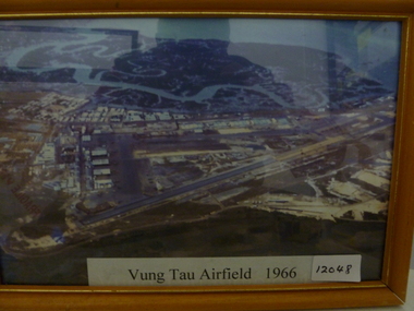 National Vietnam Veterans Museum (NVVM)
Photograph, Vung Tau Airfield 1966
... Framed coloured aerial photo of Vung Tau airfield depicting... Photograph Vung Tau Airfield -1966 Framed coloured aerial photo ...Framed coloured aerial photo of Vung Tau airfield depicting runway infrastructure and surrounding buildings.Vung Tau Airfield -1966vung tau airfield, photograph -
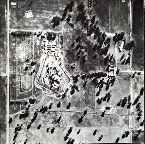 Tatura Irrigation & Wartime Camps Museum
Photograph, Aerial Photograph Dhurringile Mansion, 1940
... Dhurringile aerial photo...Black and white photograph. Aerial photo of Dhurringile... Dhurringile aerial photo Black and white photograph. Aerial photo ...Dhurringile POW camp aerial photograph. Obtain May 1989 from the Historic Photographs Department, Treasury Place, Melbourne (Central Planning Office). Black and white photograph. Aerial photo of Dhurringile Camp and surrounding area. North is at top of picture.dhurringile pow camp, dhurringile aerial photo -
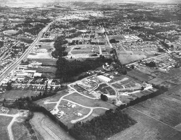
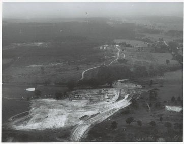 Buninyong & District Historical Society
Photograph - Original Photograph, N.L. Harvey and Sons, Ballarat, B/W photo of early site works Mt. Helen Campus of University of Ballarat, 13 May 1968
... B/W aerial photo of early site works Mt. Helen Campus... Photographers 131 Sturt Street Ballarat" B/W aerial photo of early site ...Educational historyB/W aerial photo of early site works Mt. Helen Campus of University of Ballarat.On rear, "Tertiary Institute site work at Mt. Helen commenced March 1968 (see A.R. 1967-68, p.8 Knowles and Stapleton had earthworks contract" also stamp " N.L. Harvey & Son Photographers 131 Sturt Street Ballarat"buninyong, mt. helen, ballarat university, campus, earthworks