Showing 810 items matching "aerial view"
-
 Bendigo Historical Society Inc.
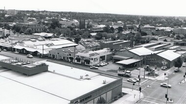
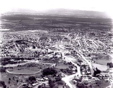
Photograph - AERIAL VIEW BENDIGO, 1995
... AERIAL VIEW BENDIGO...Aerial view of bendigo... PLACE Aerial view of bendigo Peter Hyett Black and white photo ...Black and white photo: Bendigo skyline from St. Pauls, bottom left corner of Williamson St. and Myers St., Williamson St. across centre of photo. Anne Caudle centre left on skyline. Bendigo Base Hospital centre on skyline. ( Noelene Wild - 7.2000 ) In image ' Bruce's Discount Store ' ' Nissan Symes Motors ' ' Furniture Warehouse' Bendigo Bulk Carpets' The Carpet Giants 'Peter Hyettplace, aerial view of bendigo -
 Bendigo Historical Society Inc.
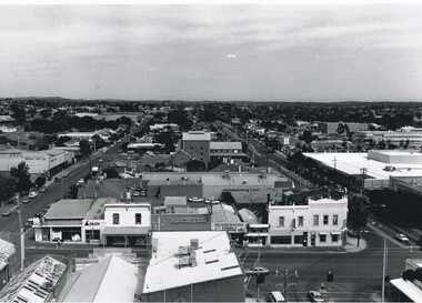
Photograph - AERIAL VIEW BENDIGO, 1995
... AERIAL VIEW BENDIGO...Aerial view of bendigo... PLACE Aerial view of bendigo Peter Hyett Black and white ...Black and white photograph: city skyline taken from St. Pauls's, Mitchell St. in foreground ( left to right ) Wills St. on RHS ( to distance ) and Garsed St. on LHS ( to distance ) Edwards St. ( next street parallel to Mitchell St. ( Noelene Wild 7.2000 )Peter Hyettplace, aerial view of bendigo -
 Bendigo Historical Society Inc.
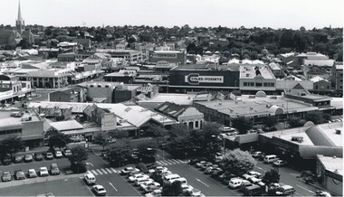
Photograph - AERIAL VIEW OF BENDIGO, 1995
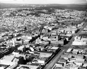
... AERIAL VIEW OF BENDIGO...Aerial view of bendigo... PLACE Aerial view of bendigo Peter Hyett Black and white photo ...Black and white photo: view of Bendigo with Mitchell St. from centre left to centre. Shows Sacred Heart Cathedral at left. Coles supermarket carpark in foreground. Dome of RSL in Pall Mall in front of trees to right. On back C 26A. Noelene Wild July 2000 ' photo by Peter Hyett 1995 from St. Paul's Myer St., Sacred Heart Cathedral at left.'Peter Hyettplace, aerial view of bendigo -
 Bendigo Historical Society Inc.
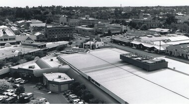
Photograph - AERIAL VIEW OF BENDIGO, 1995
... AERIAL VIEW OF BENDIGO...Aerial view of bendigo... PLACE Aerial view of bendigo Peter Hyett Black and white photo ...Black and white photo. View from St. Paul's, tower showing Coles New World, Furniture Warehouse, Webbs Flour Mill, Library, Town Hall, Shamrock Hotel, Multistorey car park. On back 'C27A'Peter Hyettplace, aerial view of bendigo -
 Ballaarat Mechanics' Institute (BMI Ballarat)
Aerial view looking south over Ballarat
... Aerial view looking south over Ballarat... aerial view above Aerial view looking south over Ballarat ...ballarat, lydiart st, sturt st, armstrong st, aerial, view, above -
 Bendigo Historical Society Inc.
Photograph - WES HARRY COLLECTION: AERIAL VIEW OF BENDIGO CBD, 1966
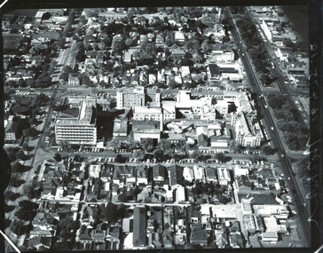
... WES HARRY COLLECTION: AERIAL VIEW OF BENDIGO CBD...Aerial view of bendigo... PLACE Aerial view of bendigo cbd Bendigo CBD Aerial Survey ...Aerial photograph of the Bendigo CBD. On the reverse is written : 'City of Bendigo 1966, State aerial Surveyplace, aerial view of bendigo, cbd, bendigo cbd, aerial survey of victoria -
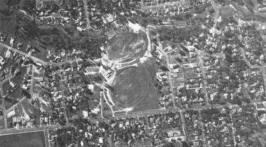
 Ballarat Base Hospital Trained Nurses League
Aerial view BBH , neg Mr Harvey Photographer
... Aerial view BBH , neg Mr Harvey Photographer...Aerial, view, BBH... Street Nth Ballarat goldfields Aerial, view, BBH Photo Aerial ...Photoaerial, view, bbh -
 Glenelg Shire Council Cultural Collection
Photograph - Photograph - aerial view of grain silos, Portland, n.d
... Photograph - aerial view of grain silos, Portland...Black and white photograph of an aerial view of grain silos... photograph of an aerial view of grain silos Photograph Photograph ...Port of Portland Authority archivesFront: (no inscriptions) Back: P.H.T./ Print No. ... Neg. No 186/ Date taken .../ SUBJECT./ ... (Ink stamp with blue pen and pencil additions, centre)port of portland archives, aerial photography, portland harbour -
Glenelg Shire Council Cultural Collection
Photograph - Photograph - aerial view of Cresco factory, Portland, c. 1960
... Photograph - aerial view of Cresco factory, Portland...Black and white photograph of an aerial view of Cresco... and white photograph of an aerial view of Cresco factory. Photograph ...Port of Portland Authority archivesFront: (no inscriptions) Back: (no inscriptions)port of portland archives, aerial photography, cresco -
 Eltham District Historical Society Inc
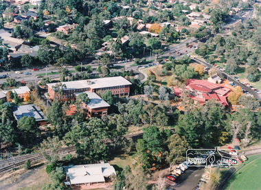
Photograph, Aerial view of Eltham Shire Office and Eltham Library precinct, 1994, 1994
... Aerial view of Eltham Shire Office and Eltham Library...Colour photograph of oblique aerial view centred on Eltham... photograph Colour photograph of oblique aerial view centred on Eltham ...Colour photograph of oblique aerial view centred on Eltham Shire Offices, 1994eltham shire office, eltham library, main road, eltham, aerial photograph -
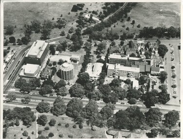
 Federation University Historical Collection
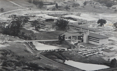
Photograph - Photograph - Black and White, Ballarat College of Advanced Education, Aerial view of the Mt Helen campus from the north, c1975
... Ballarat College of Advanced Education, Aerial view of the...black and white photograph: Aerial view of Mt Helen campus... photograph: Aerial view of Mt Helen campus from the north Ballarat ...black and white photograph: Aerial view of Mt Helen campus from the north mount helen campus, mount helen campus aerial, student residences, p building, f building, g building, l building, mt helen library, union building, u building, e.j. barker library, aerial -
 Ringwood and District Historical Society
Photograph, Aerial view taken from slide - Ringwood Lake and surrounds 1969
... Aerial view taken from slide - Ringwood Lake and surrounds...Written on plastic sleeve, "Aerial view taken from slide..., "Aerial view taken from slide - Ringwood Lake 7/8/69". Aerial view ...Written on plastic sleeve, "Aerial view taken from slide - Ringwood Lake 7/8/69". -
 Federation University Historical Collection
Photograph - Colour Photograph, Aerial View of Mt Clear, 1985, 1985
... Aerial View of Mt Clear, 1985...Aerial View of Mt Clear showing Mt Clear Technical School... clear mount clear TEchncial School canadian Creek Aerial View ...Aerial View of Mt Clear showing Mt Clear Technical School and Canadian Creek.mount clear, mount clear techncial school, canadian creek -
 Eltham District Historical Society Inc
Photograph, Aerial view of Yarra River near Kangaroo Ground - Bend of Islands area
... Aerial view of Yarra River near Kangaroo Ground - Bend of...Sepia aerial view of Yarra river at Bend of Islands; Henley... Sepia aerial view of Yarra river at Bend of Islands; Henley Road ...Sepia aerial view of Yarra river at Bend of Islands; Henley Road on left in foregroundbend of isles, kangaroo ground, yarra river, henley road -
 Ringwood and District Historical Society
Photograph, Aerial view showing Mullum Ovals 1 and 2, Mullum Road. c.1970
... Aerial view showing Mullum Ovals 1 and 2, Mullum Road. c...Aerial view showing Mullum Ovals 1 and 2, Mullum Road. c... Road Ringwood North melbourne Aerial view showing Mullum Ovals ...Aerial view showing Mullum Ovals 1 and 2, Mullum Road. c.1970. -
 International House, The University of Melbourne
Photograph (Item), Aerial view of the site of International House (includes Scheps Building)
... Aerial view of the site of International House (includes...Black and white photograph of Aerial view of the site... Building) Aerial view of the site of International House (includes ... -
Port Melbourne Historical & Preservation Society
Photograph - Aerial view of Port Melbourne, 1978
... Aerial view of Port Melbourne...Two A3 photocopies of aerial view of Port Melbourne c 1978... photocopies of aerial view of Port Melbourne c 1978 Photograph Aerial ...Two A3 photocopies of aerial view of Port Melbourne c 1978local government - city of port melbourne, phillip donnellon -
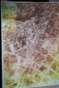
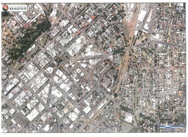 Bendigo Historical Society Inc.
Map - BENDIGO MAP AERIAL VIEW
... BENDIGO MAP AERIAL VIEW...Map of Bendigo. Aerial View of Bendigo. Published by City... PHOTOGRAPH Aerial bendigo Map of Bendigo. Aerial View of Bendigo ...Map of Bendigo. Aerial View of Bendigo. Published by City of Bendigo. Undated.photograph, aerial, bendigo -
 Ballarat and Queen's Anglican Grammar School
b&w Photograph, Aerial view of Ballarat Grammar buildings
... Aerial view of Ballarat Grammar buildings...aerial view of school buildings with large trees along... St. N. 2996 pencilled on verso aerial view of school ...aerial view of school buildings with large trees along building line and hedge around propertyVerso - N. L. HARVEY (Press Photo Service) A.M.P. Chambers Lydiard St. N. 2996 pencilled on versoballarat-grammar, education, ballarat, wendouree, school -
 University of Melbourne, Burnley Campus Archives
Photograph - Black and white print, Airspy, Aerial View of Burnley Campus c. 1925, c. 1925
... Aerial View of Burnley Campus c. 1925...Colour photograph of black and white photograph. Aerial... photograph of black and white photograph. Aerial view of Burnley ...TH Kneen and EB Littlejohn note that the Principal's House has been extended. This was done for J P McLennan, Principal 1917-1921. Note "Bird Cage" in Orchard, dwarf fruit trees, shed where tobacco was stored. Photo taken before Plant Research Institute was built in 1929. Photo shows there had been cultivation outside the College grounds, beyond the orchard area and hedge.Colour photograph of black and white photograph. Aerial view of Burnley Campus. Cultivation outside Burnley Campus burnley campus, principal's house, jp mclennan, bird cage, orchard, dwarf fruit trees, plant research institute, principal's residence, tobacco storage sheds, cultivation outside campus -
 Ringwood and District Historical Society
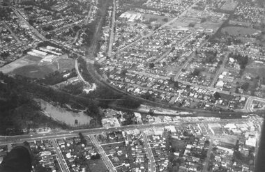
Photograph, Aerial view of the City of Ringwood - Circa 1972
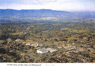
... Aerial view of the City of Ringwood - Circa 1972..."Written on face of photograph" Aerial view of the City..." Aerial view of the City of Ringwood showing Eastland (stage 1 ...Coloured photograph"Written on face of photograph" Aerial view of the City of Ringwood showing Eastland (stage 1), Ringwood High and Technical Schools. -
Port Melbourne Historical & Preservation Society
Photograph - Aerial view Webb Dock and Beacon Cove site, Port Melbourne, 6 Sep 1997
... Aerial view Webb Dock and Beacon Cove site, Port Melbourne...(.01) Aerial photographic view of Webb Dock - September... photographic view of Webb Dock - September 1997 (.02) Aerial view ...(.01) Aerial photographic view of Webb Dock - September 1997 (.02) Aerial view of cleared site for future Beacon Cove project - September 1997piers and wharves - webb dock, built environment, beacon cove -
 Glenelg Shire Council Cultural Collection
Photograph - Photograph - Unknown cargo ship, aerial view, n.d
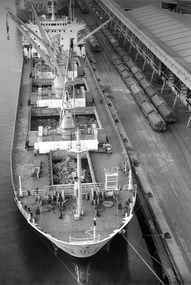
... Photograph - Unknown cargo ship, aerial view...Aerial view of cargo ship berthed at a wharf. Contents...: (no inscriptions) Back: (no inscriptions) Aerial view of cargo ship berthed ...Port of Portland Authority archives.Front: (no inscriptions) Back: (no inscriptions)port of portland archives -
 Glenelg Shire Council Cultural Collection
Photograph - Photograph - Unknown cargo ship, aerial view, n.d
... Photograph - Unknown cargo ship, aerial view...Aerial view of cargo ship berthed at a wharf. Contents...: (no inscriptions) Back: (no inscriptions) Aerial view of cargo ship berthed ...Port of Portland Authority archives.Front: (no inscriptions) Back: (no inscriptions)port of portland archives -
 Glenelg Shire Council Cultural Collection
Photograph - Photograph - aerial view of Lucerne pellets loaded onto ship, 1972
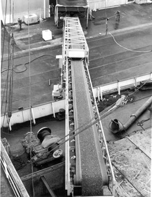
... Photograph - aerial view of Lucerne pellets loaded onto...Aerial view of Lucerne pellets for the Japanese market...: (no inscriptions) Aerial view of Lucerne pellets for the Japanese market ...Port of Portland Authority archivesFront: (no inscriptions) Back: (no inscriptions)port of portland archives, cargo, cargo handling, portland harbour, japanese cargo -
 Bendigo Historical Society Inc.
Map - BENDIGO MAP AERIAL VIEW, 1934
... BENDIGO MAP AERIAL VIEW...Map of Bendigo. Aerial View of Bendigo taken in 1934... PHOTOGRAPH Aerial bendigo 1934 Map of Bendigo. Aerial View of Bendigo ...Map of Bendigo. Aerial View of Bendigo taken in 1934. Published by City of Great Bendigo.photograph, aerial, bendigo 1934 -
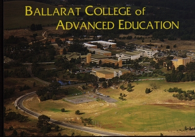 Federation University Historical Collection
Postcard - Colour, Ballarat College of Advanced Education Aerial View, c1980, c1980
... Ballarat College of Advanced Education Aerial View, c1980...Colour photographic postcard of an aerial view... photograph Colour photographic postcard of an aerial view ...Colour photographic postcard of an aerial view of the Ballarat College of Advanced Education (now Federation University) campus at Mount Helen. ballarat college of advanced education, mt helen campus, aerial photograph -
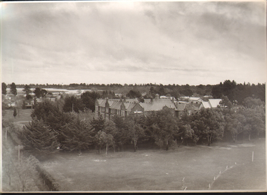
 Whitehorse Historical Society Inc.
Photograph, Aerial View of Matheson Orchard, 1944
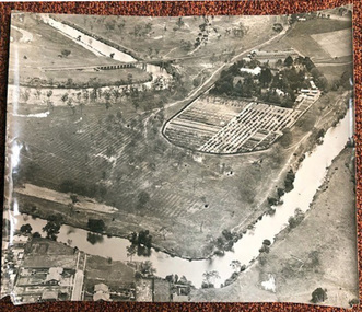
... Aerial View of Matheson Orchard....Poor photo copy of black and white photo of Aerial View... copy of black and white photo of Aerial View of Matheson ...Poor photo copy of black and white photo of Aerial View of Matheson Orchard 'Strathdon', Springvale Road , Forest Hill.matheson, strathdon orchard, orchards -
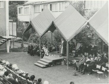 International House, The University of Melbourne
Photograph (Item), Aerial view of speakers and some audience members at the opening of the Samuel Wadham Wing at International House
... Aerial view of speakers and some audience members at the...Black and white photo of Aerial view of speakers and some... of Aerial view of speakers and some audience members at the opening ...ceremony -
 Stawell Historical Society Inc
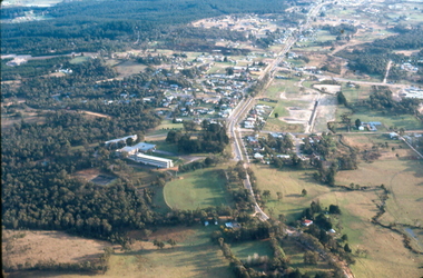
Photograph, Stawell Aerial View 1969
... Stawell Aerial View 1969...Aerial View of Stawell 1969... grampians Aerial View of Stawell 1969 Stawell Stawell Aerial View ...Aerial View of Stawell 1969stawell