Showing 2553 items
matching aerials
-
 Greensborough Historical Society
Photograph, Diamond Valley Leader, Greensborough: Aerial photograph, 21/05/2013
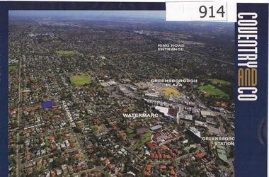
This advertisement for a property at 95 Alexandra Street Greensborough includes several aerial photographs of Greensborough with the Ring Road, Watermarc and Greensborough Plaza marked.An aerial view of Greensborough and surrounding areas in 2013.Colour advertisement including aerial photograph of Greensborough.alexandra street, greensborough plaza, watermarc -
 Greensborough Historical Society
Aerial Photograph, Watsonia North 1945, 1945_
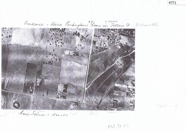
Part of 1945 aerial survey, area of Watsonia North, including Grimshaw Street, Sellars Street and Macorna Street, indicating the home of Prudence and Maria Partington in Sellars Street.Photocopy of part 1945 aerial survey"Prudence and Maria Partington's home in Sellars St. Watsonia North"watsonia north, partington family -
 Greensborough Historical Society
Aerial Photograph, AAM Photographics, Heidelberg AAM1969c 086, 24/11/1991
One of a series of four overlapping aerial photographs of the Heidelberg/Greensborough areas in 1991, covering Simpson Barracks, Macleod, Rosanna, Viewbank, Watsonia & Yallambie. North boundary Yallambie Road; West boundary Hurstbridge railway.Laminated colour aerial photographssimpson barracks, yallambie, watsonia, macleod, rosanna, viewbank -
 Greensborough Historical Society
Aerial Photograph, AAM Photographics, Heidelberg AAM1969c 088, 24/11/1991
One of a series of overlapping aerial photographs of the Heidelberg/Greensborough area, covering Eaglemont, Heidelberg, Ivanhoe East & Viewbank. North boundary Hurstbridge railway, South boundary Ivanhoe East, East boundary Bulleen RoadLaminated colour aerial photographeaglemont, heidelberg, ivanhoe east, viewbank -
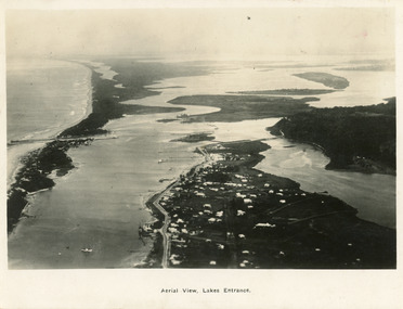 Lakes Entrance Historical Society
Postcard - Lakes Entrance, 1923c
Also large postcard 15 x 20|Also two mini postcard 6 x 9|Also copy black and white 9 x 14.5Black and white postcard of an aerial view of township of Lakes Entrance, showing western end of town, jetties and boat harbours in Cunninghame Arm, the entrance and piers, North Arm bridge, Bullock Island, Rigby, Fraser and Flannegan Islands, and a distant view of Boole Poole, Bunga Arm and Lake King. Lakes Entrance VictoriaAn aerial view showing position of Lakes Entranceaerial photograph, islands, waterways, topography, township -
 Greensborough Historical Society
Aerial Photograph, AAM Photographics, Heidelberg AAM1969c 106, 24/11/1991
One of an overlapping series of aerial photographs of the Heidelberg/Greensborough areas in 1991, covering the Simpson Barracks, Greensborough & Viewbank. North boundary Nell Street, East boundary Plenty River, South boundary Lower Plenty Road.Laminated colour aerial photographsimpson barracks, greensborough, viewbank -
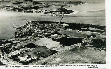 Phillip Island and District Historical Society Inc.
Photograph - Post Card, 1954
One of a collection of photographs donated by Daryl JohnsBlack & White photograph of aerial view over water and land. Newhaven in foreground and San Remo at rear of suspension bridge."The Rose Series P.14000. Aerial view showing Newhaven, San Remo & Suspension Bridge." Airspy Photo.phillip island, newhaven, san remo, daryl johns -
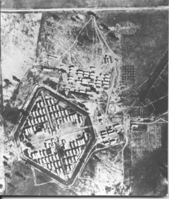 Tatura Irrigation & Wartime Camps Museum
Photograph, Aerial photo of camp 3 1946
Aerial photograph, taken in 1946 of the Rushworth internment camp.Black and white aerial photograph of camp 3 Rushworth showing layout of the camp.aerial photo of camp 3, taken in 1946, rushworth internment camp, aerial photographs, victorian internment camps -
 Creswick Campus Historical Collection - University of Melbourne
Still Image, 1952
Subject: King Lake . 6 brown envelopes marked Run 3, 4, 7, 7a, 8, 9 containing c. 80 prints. 1 section of a topographical map marked State Aerial Survey. Stored in a brown cardboard file box marked King Lake Run No.3 - 9. (x9). Photos commissioned by Forests Commission Victoria.Aerial Photographs -
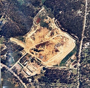 Greensborough Historical Society
Map - Aerial Photograph, Yarrambat, 04/11/1986
Colour aerial photograph of Diamond Valley Shire Depot, Yarrambat, now Nillumbik Shire Council Works Depot & Recycling CentreColour aerial photograph. Scale approx. 1:1000shire of diamond valley, yarrambat, nillumbik council -
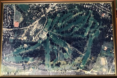
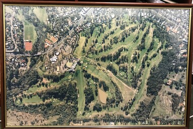
 Heidelberg Golf Club
Photograph - Framed Photograph, K. J. Kosnar, Heidelberg Golf Club: The new course, 1960s
An aerial photograph of the Heidelberg Golf Course, around late 1960s. Known as the 'new course' it was designed in 1968.One of several aerial photogrphs showing the layout of the Heidelberg Golf CourseLarge Black and white aerial photograph, metal frame with glass. heidelberg golf club, new course 1968 -
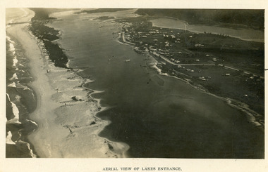 Lakes Entrance Historical Society
Photograph - Lakes Entrance, 1923c
Two copies 16.5 x 25.5 very darkBlack and white photograph showing early aerial view of township of Lakes Entrance, photo shows highway going along Myer Street and along Roadknight Street, no shops in Myer Street appears to be no foot bridge, therefore taken prior to 1937, sparce vegetation on foreground dunes, four barriers built on dunes to stop erosion through sand, two masted sailing boat in lake. Bullock Island in distance appears very small, Snake Island of Rigby Island in centre distance. Lakes Entrance VictoriaAerial View of Lakes Entrancewaterways, coast, aerial photograph, islands, township -
 Peterborough History Group
Photograph - Aerial Photograph Peterborough, Department of Crown Lands & Survey, Jan 1971
Aerial photograph showing the past layout of the townSignificant in that it shows the town as it was in 1971.Square 9" x 9" aerial photograph x 4 - (2 photos in duplicate)Stamped Dept of Crown Lands & Surveypeterborough 3270, curdies estuary, bay of islands, crown land photograph, aerial photograph, department of crown lands -
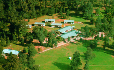 Marysville & District Historical Society
Photograph (Item) - Colour photograph, Unknown
A colour photograph of an aerial view of the lodges at the E.S.A. Camping and Conference Centre in Marysville.A colour photograph of an aerial view of the lodges at the E.S.A. Camping and Conference Centre in Marysville.marysville, victoria, australia, e.s.a. camping and conference centre, photograph -
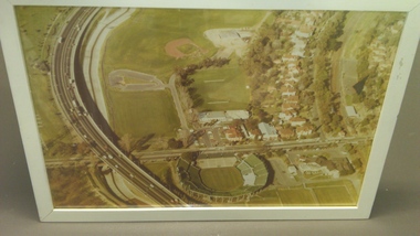
 Heidelberg Golf Club
Photograph - Framed Photograph, Heidelberg Golf Club: The new course, 1980s
An aerial photograph of the Heidelberg Golf Course, around 1980s. Known as the 'new course' it was designed in 1968. This image shows the growth of treed areas around the course.One of several aerial photogrphs showing the layout of the Heidelberg Golf CourseLarge colour aerial photograph, timber frame with glass. heidelberg golf club, new course 1968 -
Whitehorse Historical Society Inc.
Article, Blackburn North, 2013
Real estate advertisement for former orchard block of land in Blackburn North.Real estate advertisement for former orchard block of land in Blackburn North. Agent: Woodards. Aerial photo.Real estate advertisement for former orchard block of land in Blackburn North. surrey road blackburn north, no. 59-67, cock, herbert, junction road blackburn north -
 Vision Australia
Photograph - Image, Association for the Blind offices in Kooyong aerial view
Aerial view of Kooyong. The Kooyong Tennis Centre, Glenferrie Road, train station, Talbot Crescent, Monash Freeway and parklands are clearly visible. Few trees are lining the roadway around the sporting fields, the Glenferrie Road building has not expanded and the Blind Cricket pavilion is not yet built. Aerial photograph in brown frame.association for the blind, kooyong tennis centre -
 Vision Australia
Photograph - Image, Association for the Blind offices in Kooyong aerial view
Aerial view of Kooyong. The Kooyong Tennis Centre, Glenferrie Road, train station, Talbot Crescent, Monash Freeway and parklands are clearly visible. Few trees are lining the roadway around the sporting fields, the Glenferrie Road building has not expanded and the Blind Cricket pavilion is not yet built. Aerial photograph in white frameassociation for the blind, kooyong tennis centre -
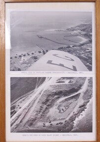 Glenelg Shire Council Cultural Collection
Photograph - Photographs - Aerial views of Portland and Cape Grant Quarry, 1957
Displayed in History House.Two photographs of aerial views in a wooden varnished frame.Front: Aerial view of Portland Harbour construction - Christmas 1957. (typed, under top image) Back: Bird's eye view of Cape Grant quarry - Christmas, 1957. (typed, under lower image)aerial photography, cape grant, portland harbour -
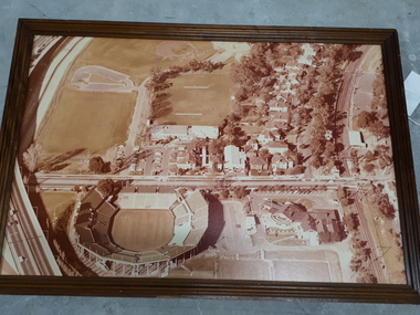
 Heidelberg Golf Club
Photograph - Framed Photograph, Heidelberg Golf Club: The new course, 1970s
An aerial photograph of the Heidelberg Golf Course, around late 1970s. Known as the 'new course' it was designed in 1968. This image shows the encroaching residential areas around the course.One of several aerial photogrphs showing the layout of the Heidelberg Golf CourseLarge colour aerial photograph, timber frame with glass. heidelberg golf club, new course 1968 -
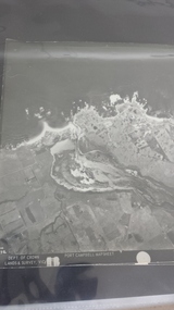
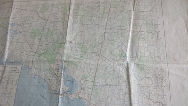 Peterborough History Group
Map - Government map, Government Printer, Port campbell, 1957
Aerial survey map showing roads, vegetation and other landscape features.Significant because it shows the detail of the region in 1957Original 1957 State Aerial Survey Map of Port Campbell region, including Peterboroughpeterborough, aerial survey map, maps, port campell -
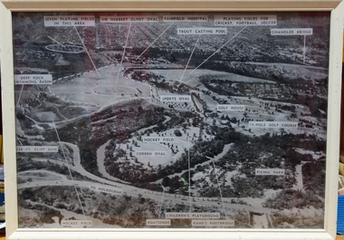 Kew Historical Society Inc
Photograph, Yarra Bend Park Trust, Yarra Bend Park Facilities, 1940s
Old aerial photograph of Yarra bend Park labelled with park facilitiesFramed annotated aerial photograph of Yarra Bend Park. The white frame is original to the work.yarra bend park, sports facilities - kew - fairfield, sir herbert olney oval, fairfield hospital, chandler bridge, deep rock swimming basin, kane's footbridge -
Glenelg Shire Council Cultural Collection
Photograph, Photograph Reclamation and Canal Work, 1959
Port of Portland Authority ArchivesFront: General view: Aerial view West showing wharf and canal areas. November 1959 - typed.port of portland -
 Greensborough Historical Society
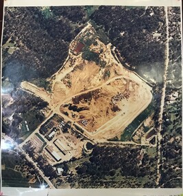
Photograph - Digital image, Frank Solomon, Pig Farm, Weidlich Road area: aerial view, 02/08/2009
An aerial view of the pig farm in Weidlich Road Greensborough, owned by Werner Hanusch. The land was used as a pig farm and quarry from 1954 and has now been subdivided into the Evelyn Way estate. This project of fifty, one double storey, dwellings was commenced on 2/8/2009 and completed on 6/2/2011.An example of the changing land use in Greensborough, from farming to residential.Digital copy of aerial photographwerner otto fritz hanusch, pig farm st helena, weidlich road greensborough, one evelyn way greensborough -
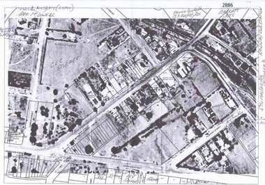 Greensborough Historical Society
Aerial Photograph, Greensborough, 1945_
Aerial photograph of Greensborough showing residents and businesses in the area. Annotations by Bill Cecil.Photocopy of enlargement of 1945 aerial photograph, with 2 p. of annotations indicating locations of residents and businessesgreensborough, bill cecil -
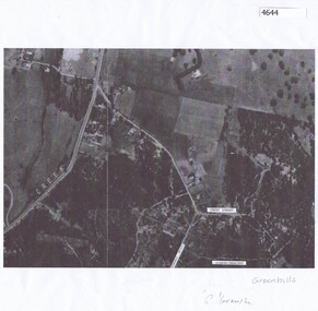 Greensborough Historical Society
Aerial Photograph, Greenhills Aerial View, 1945_
Section from the 1945 aerial survey of Greensborough, including part of Diamond Creek Road, Greenhill Road, Crest Street and Albion Crescent.Photocopy of part of 1945 aerial survey. Some streets have been marked.greenhills -
Port Fairy Historical Society Museum and Archives
Photograph
aerial view over Port Fairy looking across the river at the railway line and butter factoryBlack and white aerial photograph of Port Fairy looking across the Moyne river and railway stationaerial, railway, river, town -
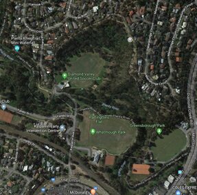 Greensborough Historical Society
Aerial Photograph - Digital Image, Greensborough central with modern landmarks, 2015_
Aerial photograph of Greensborough showing modern landmarks and businesses, including Partington's Flat, Whatmough Park, Plenty River Trail. Bounded by Diamond Creek Road to the East and the Plenty River to the East, The Circuit to the South. Aerial photograph in colour with overlay text indicating modern landmarksgreensborough, manatunga circuit greensborough, plenty river, diamond creek road greensborough, the circuit greensborough, aerial photograph -
Frankston RSL Sub Branch
Computer, Navigation
Aerial Dead Reckoning Computer in leather pouch. This device was used as a navigational aid by aircraft pilots and crew. W&G Aerial Dead Reckoning Computer R.A.A.F. Mk 1 Made in Australia by White & Gillespie Front Scale: Distance Naut Miles, True Air Speed (Time Min, Hrs, Density Altitude, Air Temp ) Back Scale: Wind Correction Angle( True Heading ) The leather pouch has the following printed on the outside "W&G Aerial Dead Reckoning Computer R.A.A.F. Mk 1" -
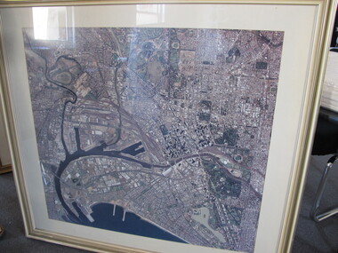 Mission to Seafarers Victoria
Photograph - Aerial Photograph, 1980-1997
Aerial view of Melbourne pre October 1997 as the Docklands stadium, landmark of the new precinct is not yet built.Large framed and glazed print of aerial colour photograph of the Yarra river and Docklands, C - 1982 - 1995 docklands, melbourne, aerial view, yarra river, city, port melbourne, albert park