Showing 73 items matching "aircraft navigation"
-
 Port Fairy Historical Society Museum and Archives
Vehicle - Artefact, 1930s
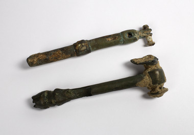
Retrieved from crashed (during W.W.2) Avro Anson aircraft at Propeller Bay near Lady Julia Percy Island in 13 metres of water. Found adjacent to the remains of the engine and propeller in June 1993 by Peter Ronald. It was possibly used to adjust control cables. The plane went down on the 15th February 1944 Flight Sgt. J.H. MacLellen, Flight Sgt D.l. Baulderstone, LAC N.T. Kruck, LAC B.C. Ladyman were killed. A memorial was erected at the 'Crags' on the 14th of February 2015 . " At 0800 Anson AW878 of 2AOS took off from Mount Gambier to carry out a radius of action navigation exercise to Lady Julia Percy Island (located off the Victorian coast, midway between Portland and Warrnambool) and back to Mount Gambier. By 1230 it was overdue, and that afternoon a search was instituted. No radio messages had been received from the Anson, although it had been seen during the exercise by another aircaraft. At 1430 part of the mainplane was sighted on Lady Julia Percy Island. Subsequently a fishing boat searched in the vicinity of the island and passed through small pieces of wreckage strewn over about 3 miles. A further search uncovered wreckage which identified the plane beyond doubt, including fuel tank bay cover with AW878 penciled on it, and a Mae West which had been signed out by one of the crew. The bodies of the four crew were never located." This information comes from a report at Mt Gambier Airport where the plane was stationed.Two small pieces of metal that bring the reality of war to our shoresArtefact from crashed aircraft at Lady Julia Percy islandlocal history, transport, aviation, aircraft, lady julia percy island, j.h. maclellen, d.l. baulderstone, n.t. kruck, b.c. ladyman -
 Wodonga & District Historical Society Inc
Book - Going My Way, Russell J Kelly, Going My Way - The story of the Mysterious Crash of a Beaufort Bomber, 2000
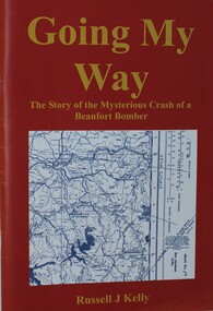
This book tracks the crash of the RAAF Beaufort, A9-228 which crashed in the mountains near Eskdale, Victoria and the search to locate the wreckage. On the night of 4 June 1945, just weeks before the end of World War 1, a Beaufort Bomber went missing whilst conducting a navigational exercise between Mount Gambier in South Australia and Sale in Victoria.The aircraft was meant to head east, but instead it headed north east due to a series of navigational errors. It flew over Albury, circled and then headed towards the Victorian Alps. It flew over the town of Eskdale in Northeast Victoria and crashed into the side of Mount Tawonga. All crew on board perished. Those lost were Flight Officer Don Flavel (pilot), Flight Officer Robert Clayton (navigator), Flight Officer Fred Wallis and Flight Sergeant L. J. Sims (radio operator). At the time of the crash, many members of the Eskdale community were in the public hall just beginning to watch a screening of the Bing Crosby movie, "Going My Way". This accounts for the title of the publication.A 62 page book outlining the loss of the Beaufort Bomber and the search to locate it. The book includes maps, illustrations and a bibliography. The cover features a map of the search area for the bomber.This book tracks the crash of the RAAF Beaufort, A9-228 which crashed in the mountains near Eskdale, Victoria and the search to locate the wreckage. On the night of 4 June 1945, just weeks before the end of World War 1, a Beaufort Bomber went missing whilst conducting a navigational exercise between Mount Gambier in South Australia and Sale in Victoria.The aircraft was meant to head east, but instead it headed north east due to a series of navigational errors. It flew over Albury, circled and then headed towards the Victorian Alps. It flew over the town of Eskdale in Northeast Victoria and crashed into the side of Mount Tawonga. All crew on board perished. Those lost were Flight Officer Don Flavel (pilot), Flight Officer Robert Clayton (navigator), Flight Officer Fred Wallis and Flight Sergeant L. J. Sims (radio operator). At the time of the crash, many members of the Eskdale community were in the public hall just beginning to watch a screening of the Bing Crosby movie, "Going My Way". This accounts for the title of the publication.beaufort bomber crash 1945, beaufort bomber eskdale, aircraft accidents victoria -
 Department of Energy, Environment and Climate Action
Hasselblad aerial camera
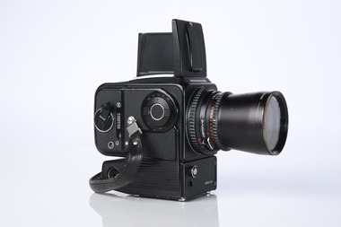
Aerial photos were used to make maps of forest types, timber resources, to survey logging areas and regeneration, to mark boundaries of public land and new plantations, to identify new roads and tracks, as well as for fire suppression. Infrared film was sometimes used to monitor insect and disease attack. The images needed to sharp, with high contrast, and in a large format (most were printed in B&W on 9-inch by 9-inch glossy photographic paper) with at least a 60% overlap to enable stereoscopic viewing and with a 20-30% side lap to allow for aircraft drift. Preferably, the photo scale was close to the final map scale avoid to problems when enlarging and to reduce distortion. Something was needed to supplement the very expensive and infrequent large-area photography programs. From the mid-1960s Victorian foresters began experimenting with small format 70mm and 35mm cameras which proved simple, practical, cheap and flexible. It was found that any SLR camera could be used provided it had a good quality lens and fast shutter speed (preferably down to 1/1000 second). Motorised cameras with a large film capacity had obvious advantages and were essential when access to the camera was not possible during flight. It is also essential for the shutter to operate at low temperatures and those lubricated with silicones were recommended. Components of a typical FCV Divisional Office system included – A Hasselblad or Vinten 70 mm format aerial camera with a focal plane shutter which could be electrically operated. Interchangeable lenses to allow for different photo scales and flying heights. Several large film magazines, which were loaded in a darkroom, each with a capacity of 100 feet or approximately 500 frames. A remote control for the camera in single-shot mode or automatic firing at selected intervals of 2 to 50 seconds. It also needed a frame counter. A light aircraft was modified with an internal mounting for the camera to keep it level and steady. Often a hole was cut through the floor for the lens. The aircraft also needed an inbuilt 12 Volt DC battery to operate the motorised camera shutter. The front passenger seat was generally removed to improve access to the camera. An Aldis drift sight was also fitted. This might be likened to an inverted periscope and is used to determine drift, to facilitate accurate navigation along flight lines and to determine the exposure interval for stereoscopic overlap. This item is kept at Traralgon.Hasselblad 500 ELM camera with 70mm lens, film pack, motor drive and battery In 1964 Hasselblad started production of a motorized camera, the 500 EL The EL/M is a modified version of the EL, "M" means modified, "EL" electric. Perhaps the most famous use of the Hasselblad camera was during the Apollo program missions when man first landed on the Moon. Almost all of the still photographs taken during these missions used modified Hasselblad cameras. forests commission victoria (fcv), forest measurement, surveying, mapping -
 Bendigo Military Museum
Photograph - 4th Field Survey Squadron – Operation ARIGHT 93, Queensland, 1993
This is a set of 42 photographs taken during 4th Field Survey Squadron’s deployment on Operation ARIGHT 93 in North Queensland from the 30th of August to the 8th of October 1993. The Survey Field Completion area of operations was Weipa near the top end of the Cape York Peninsula. Survey parties conducted field checking of topographic maps covering Bamaga, Heathlands, Weipa, Lockhart River and Strathgordon in Perentie 110 Series Survey variant FFR Land Rovers. Hand-held Trimble and Magellan GPS receivers were used to assist with navigation and to position remote isolated features. Three Bell Kiowa LOH helicopters provided by 162 Recce Sqn supported field checking operations. Supplementary and Vital Asset Protection photography was taken by air camera operators in AAAvn Nomad aircraft from 173 Survl Sqn fitted with an RC10 aerial camera.This is a set of 42 photographs taken in 1993 durin8g 4th Field Survey Squadron’s deployment on Operation ARIGHT in North Queensland. The colour photographs are on 35mm negative film and are part of the Army Survey Regiment’s Collection. The photographs were scanned at 96 dpi. .1) - Photo, colour, 1993. Survey party in Perentie 110 Series Land Rover navigates through Cape York Peninsula sand hills. .2) - Photo, colour, 1993. Cape York Peninsula sand hills. .3) - Photo, colour, 1993. Cape York Peninsula Island. .4) - Photo, colour, 1993. Survey party in Perentie 110 Series Land Rover enters a Cape York Peninsula beach. .5) - Photo, colour, 1993. SPR Kim Baker takes a break on a Cape York Peninsula beach. .6) - Photo, colour, 1993. L to R: MAJ Andy Cordova (USA Exchange) from the Army Survey Regiment and unidentified civilians. .7) to .14) - Photo, colour, 1993. Cape York Peninsula topography. .15) - Photo, colour, 1993. Unidentified surveyor in Bell Kiowa LOH helicopter. .16) - Photo, colour, 1993. Bell Kiowa LOH helicopter circles base camp. .17) to .18) - Photo, colour, 1993. Cape York Peninsula topography. .19) - Photo, colour, 1993. Vehicle convoy taking a break. L to R: LT John Bath (Detachment OC), unidentified (x2), SPR Chris Pearse. .20) - Photo, colour, 1993. Vehicle convoy taking a break. .21) - Photo, colour, 1993. Vehicle convoy ready to go. SPR Chris Pearse. .22) - Photo, colour, 1993. Vehicle convoy on the move. .23) - Photo, colour, 1993. Cape York Peninsula topography. .24) - Photo, colour, 1993. Unidentified personnel. .25) - Photo, colour, 1993. SGT Neale ‘Tex’ Houston. .26) - Photo, colour, 1993. Ground below a Bell Kiowa LOH helicopter .27) - Photo, colour, 1993. L to R: SPR Mark Sinderberry and CPL Stuart Adrain in a Bell Kiowa LOH helicopter. .28) & .29) - Photo, colour, 1993. Ground below a Bell Kiowa LOH helicopter. .30) - Photo, colour, 1993. Base camp viewed from a Bell Kiowa LOH helicopter. .31) - Photo, colour, 1993. Cape York Peninsula topography in recovery after burn-off. .32) & .33) - Photo, colour, 1993. SPR Kim Baker contemplates crossing this bridge in his Land Rover. .34) - Photo, colour, 1993. SPR Kim Baker takes a break next to a billabong. .35) - Photo, colour, 1993. Survey party in Perentie 110 Series Land Rover crosses a creek. .36) - Photo, colour, 1993. Cape York Peninsula bush fire in distance. .37) - Photo, colour, 1993. Survey party in Perentie 110 Series Land Rover traverses a sand hill. .38) - Photo, colour, 1993. SPR Kim Baker. .39) - Photo, colour, 1993. Cape York Peninsula bush fire. .40) - Photo, colour, 1993. Cape York Peninsula topography. .41) & .42) - Photo, colour, 1993. Cape York Peninsula sand hills..1P to .42P – There are no personnel identified. ‘1993 OP ARIGHT’ annotated on negative sleeve.royal australian survey corps, rasvy, 4 fd svy sqn, op aright 93 -
 Moorabbin Air Museum
Document (Item) - (SP) Percival Aircraft draft technical modifications leaflet
... Possibly related to navigation Document (SP) Percival ...Possibly related to navigation -
 Moorabbin Air Museum
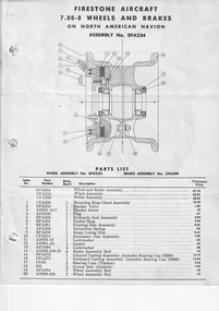
Document (Item) - (SP) Firestone Aircraft Wheels and Brakes on Navion DFA234
... Possibly related to navigation Document (SP) Firestone ...Possibly related to navigation -
 Moorabbin Air Museum
Document (Item) - (SP) Percival IV and V Aircraft modifications advice
Possibly related to navigation -
 Moorabbin Air Museum
Book - A 1950's description of all things to do with operation of civilian aircraft and airports, ie such things as navigation, air space control, general air craft engine types, aircraft design. Does not have specific aircraft detail. THE WORLD'S AIRWAYS AND HOW THEY WORK, CAPTAIN J. W. G. JAMES, JOHN STROUD, THE WORLD'S AIRWAYS AND HOW THEY WORK, 1950
A 1950's description of all things to do with operation of civilian aircraft and airports, ie such things as navigation, air space control, general air craft engine types, aircraft design. Does not have specific aircraft detail. THE WORLD'S AIRWAYS AND HOW THEY WORKCover jacket showing black and white sketch of 1950's four radial engine passenger aircraft in flight, between orange coloured band top and bottom of cover.non-fictionA 1950's description of all things to do with operation of civilian aircraft and airports, ie such things as navigation, air space control, general air craft engine types, aircraft design. Does not have specific aircraft detail. THE WORLD'S AIRWAYS AND HOW THEY WORK -
Moorabbin Air Museum
Magazine - The BASI Journal - Bureau of Air Safety Investigation, The Basi Journal 10
... yaw, drugs, air safety & the media, air navigation laws ...Articles on heicopter yaw, drugs, air safety & the media, air navigation laws, aircraft accidents smoke & dust haze. Circa Dcember 1991MagazineArticles on heicopter yaw, drugs, air safety & the media, air navigation laws, aircraft accidents smoke & dust haze. Circa Dcember 1991 -
Moorabbin Air Museum
Manual - RAAF Air reservist manuals, Royal Austrralian Air Force Manual for Air Crew Reservists
... of flight Overview of flight, aircraft systems, navigation, etc ...Overview of flight, aircraft systems, navigation, etc. for RAAF Reservists circa 1940Manual in book formOverview of flight, aircraft systems, navigation, etc. for RAAF Reservists circa 1940aircraft systems, navigtion, principles of flight -
Moorabbin Air Museum
Book - Technical pilot interviews, Act The Technical Pilot Interview
Technical questions/answers & illustrations covering light aircraft to heavy jet operations, circa 1993Technical questions/answers & illustrations covering light aircraft to heavy jet operations, circa 1993aerodynamics, engines, navigation, instruments, and more -
 Moorabbin Air Museum
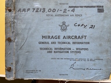
Manual (Item) - (SP) AAP 7213.001-2-4 RAAF Pub 721:3 Mirage aircraft general and technical information weapons and navigation systems Volume 1 Part 2 Book 1
-
Moorabbin Air Museum
Document (item) - Wackett trainer Boomerang CA15 Mustang Spitfire Mignet H.M. 14 Pou-du- Ciel Curtiss Hawk 75A-4 CurtissP-40E Kittyhawk Cloth Map South Celebes The Griff Falcon flapping wing Repco Steering Shaft M14A2401 1140 series Tugan LJW7 Monoplane Gannet Rotol contra rotating propeller Rolls Royce BS 360 engine oil system Avro York Handley Page nosewheel Douglas DC10 Auster aircraft Autocrat 5J1 Taylor aircraft Sulu Archipelago Philippines Victoria Australia radio centres FISCOM Tasmania air navigation chart Wagga Wagga Charleville navigation map Broken Hill Bourke New Guinea Bismarck sea Coral sea Solomon islands Gulf of Carpentaria Tennant creek Mackay Palau Suain east and west Nanu east and west Hauk East Aitape East Maprik West But west Rockhampton map Australian built beaufort poster Beaufighter 30 Squadron Poster Woomera 737 overhead instrument panel Uiver London to Melbourne 1934 1984 memorial flight Poster Air India to Australia Poster, Posters of aircraft navigational maps schematics of engines instrument panel drawings
... Posters of aircraft navigational maps schematics of engines ...