Showing 404 items matching "bank records"
-
 Warrnambool and District Historical Society Inc.
Financial record - Bank Book, Bank of Australasia, Burnley Melbourne, 1939
... on the inside back cover. Financial record Bank Book Bank of Australasia ...This bank book is from the Bank of Australasia branch in Burnley, Melbourne and records the financial transactions of Mrs May Ferguson from July 1939 to June 1944 with an additional entry for 1955. Mrs Ferguson was related to Thomas Ferguson of Dennington, Warrnambool. The Bank of Australasia was established in Sydney in 1835 (Warrnambool in 1854) and joined with other banks in the 1950s to form the present day, ANZ Bank.This book has little local provenance but is of interest as an example of a pass book from the Bank of Australasia, an important early bank in Warrnambool.This is a bank pass book with a dark blue cloth cover. The pages are ruled with black lines and contain printed material and handwritten material in black and red ink. The pages are stapled. There is some scribble on the inside back cover.Mrs May Fergusonbank of australasia, mrs may ferguson, anz bank -
 Warrnambool and District Historical Society Inc.
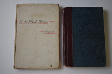
Administrative record - Cash Books, Christ Church Wardens Folio 781, 1930s
These two notebooks come from Christ Church in Warrnambool. One contains the cash transactions of the Christ Church wardens (Folio 78) with the National Bank of Australasia (1932-1938) and the other contains the financial transactions of the Christ Church Parochial Missionary Association, Warrnambool (1933-1940). The Anglican Christ Church in Warrnambool was opened in 1856 with the addition of the nave in 1860 and the square tower in 1882. These cash books are of historic interest as records of financial transactions of Christ Church in Warrnambool in the first half of the 20th century..1 A buff-coloured, hard cover notebook with handwriting on the front cover. The pages contain ruled black lines and printing and handwritten material in black and red ink. .2 A hard cover notebook with a blue cover with dark red leather binding. The pages contain printed red lines and handwritten material in black ink.Christ Church Parochial Missionary Association Warrnamboolchrist church warrnambool, christ church parochial missionary association -
 Warrnambool and District Historical Society Inc.
Administrative record - Bank Cash Book, Early 20th century
... . Administrative record Bank Cash Book National Bank Personnel ...This cash book comes from the National Bank of Warrnambool and the entries date from 1909 to 1911.The Warrnambool National Bank opened in 1867. The bank opened in temporary premises in Timor Street and in 1869 it moved to a new stone building on the corner of Timor and Kepler Streets which it occupied until 1975. The National Australia Bank still operates today in Koroit Street.This cash book is of considerable interest mostly because of the listing of local names in the early 20th Century.This is a ledger used as a cash book. It has printed red lines and hand written entries in black and red ink. It also has the National Bank stamp. The hard board cover has a mottled pattern on the back and the front and is completely detached from the pages.warrnambool banks, warrnambool national bank, bank ledger 1910 -
 Eltham District Historical Society Inc
Postcard - Photograph postcard, The Rapids, Devils' Bank, Eltham, 1907
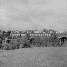
Devils' Bank was situated some two miles from Eltham. It is probably the section along the Yarra River where there are a series of rapids stretching past Petty's Orchard to Griffiths Park and the confluence with the Diamond Creek. Only three properties existed in this area in 1945 aerial maps, Worlingworth and the adjoining property on the bank of the Diamond Creek in Banoon Road and No. 2 Kent Hughes Road. Devils' Bank. The death of Ann Edwards, 77 years, an old resident of the district was reported who lived in an old hut at Devil's Bank who had been found dead in her bed on 13 May 1897 FOUND DEAD IN BED. (1897, May 28). Evelyn Observer, and South and East Bourke Record (Vic. : 1882 - 1902), p. 2 (MORNING.). Retrieved September 3, 2022, from http://nla.gov.au/nla.news-article60696388 A very similar view was published in the Leader paper in January 1908 - Devil's Bank Falls, Eltham VIEWS ON THE UPPER YARRA. (1908, January 11). Leader (Melbourne, Vic. : 1862 - 1918, 1935), p. 28. Retrieved September 3, 2022, from http://nla.gov.au/nla.news-article198106006 On the reverse of the postcard it appears to be postmarked Eltham, Dec 27, 1907 addressed to Mrs Christie Millmoss of Bull Street, Bendigo "Arrived here 10.45 am - ? ? raining cause of ? - ? till evenings it is lovely - but quite fresh after the (rain - crossed out) great ? - I may assume it all go well"Digital file only Postcards scanned from the collection of Michael Aitken on loan to EDHS, 2 Sep. 2022michael aitken collection, devils bank, eltham, postcards, rapids, yarra river -
 Eltham District Historical Society Inc
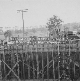
Album - Photograph, J.A. McDonald, Dixons Creek Road, June 1957
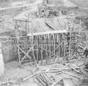
Bridge over Dixons Creek Job 56FD330 June 1957 Formwork for Dixons Creek pier completed Advertising (1957, January 19). The Argus (Melbourne, Vic. : 1848 - 1957), p. 33 (Col. 9). Retrieved August 24, 2022, from http://nla.gov.au/nla.news-article71777065 SHIRE OF ELTHAM. Loan No. 27.-Notice of Intention to Borrow Sum of £ 15,000 for Permanent Works and Undertakings. - Notice is hereby given, that the Council of the Shire of Eltham proposes to borrow the sum of £15,000 on the credit of the municipal revenues of the president, councillors, and ratepayers for the said shire, such sum to be raised by the Issue of debentures in accordance with the provisions of the Local Government Acts. 1. Maximum rate of interest that may be paid is £5/10/ per cent, per annum. 2. The purposes for which the loan is to be applied are: Construction of Sanitary Conveniences at Shire Office, Council's contribution towards costs of Dixons Creek Bridge, Construction of Mt. Pleasant rd., Construction of Cherry Tree rd. 3. The period of the loan shall be 10 years. 4. Moneys borrowed will be repayable by providing out of the Municipal Fund twenty half-yearly instalments of approximately £985/1/6 each, including principal and interest on the first day of October and the first day of April during the currency of the loan. The first Instalment shall be payable on the first day of October 1957. 5. Such moneys shall be repayable at the Commercial Bank of Australia Limited, Melbourne, or at the Council's bankers for the time being in Melbourne. The plans and specifications and the estimates of the costs of the proposed works and a statement showing the proposed expenditure of the moneys to be borrowed are open for inspection at the Shire Office, Eltham. R. J. HAM. Shire Secretary.Record of various Shire of Eltham infrastructure works undertaken during the period of 1952-1962 involving bridge and road reconstruction projects, sometimes with Eltham Shire Council Project Reference numbers quoted. It was during this period that a number of significant improvements were made to roads and new bridges constructed within the shire that remain in place as of present day (2022). In many situations, the photos provide a tangible visible record of infrastructure that existed throughout the early days of the Shire. The album was put together by or under the direction of the Shire Engineer, J.A. McDonald.infrastructure, road construction, shire of eltham, bridge construction, dixons creek bridge, dixon's creek road, 1957-06 -
 Eltham District Historical Society Inc
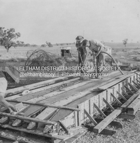
Album - Photograph, J.A. McDonald, Dixons Creek Road, June 1957
Piles being cast 1957 P. Morris on vibrator Advertising (1957, January 19). The Argus (Melbourne, Vic. : 1848 - 1957), p. 33 (Col. 9). Retrieved August 24, 2022, from http://nla.gov.au/nla.news-article71777065 SHIRE OF ELTHAM. Loan No. 27.-Notice of Intention to Borrow Sum of £ 15,000 for Permanent Works and Undertakings. - Notice is hereby given, that the Council of the Shire of Eltham proposes to borrow the sum of £15,000 on the credit of the municipal revenues of the president, councillors, and ratepayers for the said shire, such sum to be raised by the Issue of debentures in accordance with the provisions of the Local Government Acts. 1. Maximum rate of interest that may be paid is £5/10/ per cent, per annum. 2. The purposes for which the loan is to be applied are: Construction of Sanitary Conveniences at Shire Office, Council's contribution towards costs of Dixons Creek Bridge, Construction of Mt. Pleasant rd., Construction of Cherry Tree rd. 3. The period of the loan shall be 10 years. 4. Moneys borrowed will be repayable by providing out of the Municipal Fund twenty half-yearly instalments of approximately £985/1/6 each, including principal and interest on the first day of October and the first day of April during the currency of the loan. The first Instalment shall be payable on the first day of October 1957. 5. Such moneys shall be repayable at the Commercial Bank of Australia Limited, Melbourne, or at the Council's bankers for the time being in Melbourne. The plans and specifications and the estimates of the costs of the proposed works and a statement showing the proposed expenditure of the moneys to be borrowed are open for inspection at the Shire Office, Eltham. R. J. HAM. Shire Secretary.Record of various Shire of Eltham infrastructure works undertaken during the period of 1952-1962 involving bridge and road reconstruction projects, sometimes with Eltham Shire Council Project Reference numbers quoted. It was during this period that a number of significant improvements were made to roads and new bridges constructed within the shire that remain in place as of present day (2022). In many situations, the photos provide a tangible visible record of infrastructure that existed throughout the early days of the Shire. The album was put together by or under the direction of the Shire Engineer, J.A. McDonald.infrastructure, road construction, shire of eltham, bridge construction, dixons creek bridge, dixon's creek road, 1957-06, p. morris -
 Eltham District Historical Society Inc
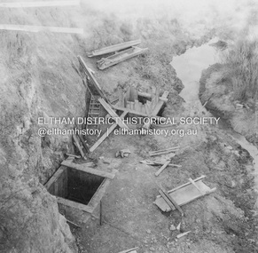
Album - Photograph, J.A. McDonald, Dixons Creek Road, June 1957
Dixons Creek Road P. Morris – Contractor Dixons Creek (North) abutment 1957 Advertising (1957, January 19). The Argus (Melbourne, Vic. : 1848 - 1957), p. 33 (Col. 9). Retrieved August 24, 2022, from http://nla.gov.au/nla.news-article71777065 SHIRE OF ELTHAM. Loan No. 27.-Notice of Intention to Borrow Sum of £ 15,000 for Permanent Works and Undertakings. - Notice is hereby given, that the Council of the Shire of Eltham proposes to borrow the sum of £15,000 on the credit of the municipal revenues of the president, councillors, and ratepayers for the said shire, such sum to be raised by the Issue of debentures in accordance with the provisions of the Local Government Acts. 1. Maximum rate of interest that may be paid is £5/10/ per cent, per annum. 2. The purposes for which the loan is to be applied are: Construction of Sanitary Conveniences at Shire Office, Council's contribution towards costs of Dixons Creek Bridge, Construction of Mt. Pleasant rd., Construction of Cherry Tree rd. 3. The period of the loan shall be 10 years. 4. Moneys borrowed will be repayable by providing out of the Municipal Fund twenty half-yearly instalments of approximately £985/1/6 each, including principal and interest on the first day of October and the first day of April during the currency of the loan. The first Instalment shall be payable on the first day of October 1957. 5. Such moneys shall be repayable at the Commercial Bank of Australia Limited, Melbourne, or at the Council's bankers for the time being in Melbourne. The plans and specifications and the estimates of the costs of the proposed works and a statement showing the proposed expenditure of the moneys to be borrowed are open for inspection at the Shire Office, Eltham. R. J. HAM. Shire Secretary.Record of various Shire of Eltham infrastructure works undertaken during the period of 1952-1962 involving bridge and road reconstruction projects, sometimes with Eltham Shire Council Project Reference numbers quoted. It was during this period that a number of significant improvements were made to roads and new bridges constructed within the shire that remain in place as of present day (2022). In many situations, the photos provide a tangible visible record of infrastructure that existed throughout the early days of the Shire. The album was put together by or under the direction of the Shire Engineer, J.A. McDonald.infrastructure, road construction, shire of eltham, bridge construction, dixons creek bridge, dixon's creek road, 1957-06 -
 Eltham District Historical Society Inc
Album - Photograph, J.A. McDonald, Dixons Creek Road, June 1957
Dixons Creek Road Bridge over Dixons Creek – 56FD330 June 1957 Dixons Creek pier forming columns and beam Advertising (1957, January 19). The Argus (Melbourne, Vic. : 1848 - 1957), p. 33 (Col. 9). Retrieved August 24, 2022, from http://nla.gov.au/nla.news-article71777065 SHIRE OF ELTHAM. Loan No. 27.-Notice of Intention to Borrow Sum of £ 15,000 for Permanent Works and Undertakings. - Notice is hereby given, that the Council of the Shire of Eltham proposes to borrow the sum of £15,000 on the credit of the municipal revenues of the president, councillors, and ratepayers for the said shire, such sum to be raised by the Issue of debentures in accordance with the provisions of the Local Government Acts. 1. Maximum rate of interest that may be paid is £5/10/ per cent, per annum. 2. The purposes for which the loan is to be applied are: Construction of Sanitary Conveniences at Shire Office, Council's contribution towards costs of Dixons Creek Bridge, Construction of Mt. Pleasant rd., Construction of Cherry Tree rd. 3. The period of the loan shall be 10 years. 4. Moneys borrowed will be repayable by providing out of the Municipal Fund twenty half-yearly instalments of approximately £985/1/6 each, including principal and interest on the first day of October and the first day of April during the currency of the loan. The first Instalment shall be payable on the first day of October 1957. 5. Such moneys shall be repayable at the Commercial Bank of Australia Limited, Melbourne, or at the Council's bankers for the time being in Melbourne. The plans and specifications and the estimates of the costs of the proposed works and a statement showing the proposed expenditure of the moneys to be borrowed are open for inspection at the Shire Office, Eltham. R. J. HAM. Shire Secretary.Record of various Shire of Eltham infrastructure works undertaken during the period of 1952-1962 involving bridge and road reconstruction projects, sometimes with Eltham Shire Council Project Reference numbers quoted. It was during this period that a number of significant improvements were made to roads and new bridges constructed within the shire that remain in place as of present day (2022). In many situations, the photos provide a tangible visible record of infrastructure that existed throughout the early days of the Shire. The album was put together by or under the direction of the Shire Engineer, J.A. McDonald.infrastructure, road construction, shire of eltham, bridge construction, dixons creek bridge, dixon's creek road, 1957-06 -
 Eltham District Historical Society Inc
Album - Photograph, J.A. McDonald, Eltham-Greensborough Road, June 1956
Diamond Creek Bridge (Bridge Street Bridge) Deck being stripped June 1956 View looking southeast from the western bank of the Diamond Creek close to the present-day Eltham Skatepark. On the far centre left can be seen the Eltham Methodist Church on the cirner of John Street and Main Road, now the Eltham-Montmorency Uniting ChurchRecord of various Shire of Eltham infrastructure works undertaken during the period of 1952-1962 involving bridge and road reconstruction projects, sometimes with Eltham Shire Council Project Reference numbers quoted. It was during this period that a number of significant improvements were made to roads and new bridges constructed within the shire that remain in place as of present day (2022). In many situations, the photos provide a tangible visible record of infrastructure that existed throughout the early days of the Shire. The album was put together by or under the direction of the Shire Engineer, J.A. McDonald.infrastructure, road construction, shire of eltham, bridge construction, 1956-06, bridge street bridge, eltham, eltham-greensborough road, methodist church, presbyterian church, uniting church -
 Eltham District Historical Society Inc
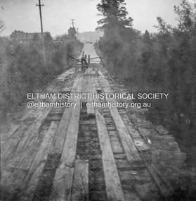
Album - Photograph, J.A. McDonald, Eltham-Greensborough Road, 26 July 1956
Diamond Creek Bridge (Bridge Street Bridge) Old bridge from N.W. bank Handrails stripped – 26/7/56 View looking west along bridge to Susan Street intersection with barriers placed across the roadRecord of various Shire of Eltham infrastructure works undertaken during the period of 1952-1962 involving bridge and road reconstruction projects, sometimes with Eltham Shire Council Project Reference numbers quoted. It was during this period that a number of significant improvements were made to roads and new bridges constructed within the shire that remain in place as of present day (2022). In many situations, the photos provide a tangible visible record of infrastructure that existed throughout the early days of the Shire. The album was put together by or under the direction of the Shire Engineer, J.A. McDonald.infrastructure, road construction, shire of eltham, bridge construction, bridge street bridge, eltham, eltham-greensborough road, 1956-07-26 -
 Eltham District Historical Society Inc
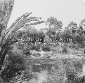
Album - Photograph, J.A. McDonald, Eltham-Templestowe Road, c. 1957
... melbourne Site for bridge over Yarra River looking from Eltham bank ...Site for bridge over Yarra River looking from Eltham bank.Record of various Shire of Eltham infrastructure works undertaken during the period of 1952-1962 involving bridge and road reconstruction projects, sometimes with Eltham Shire Council Project Reference numbers quoted. It was during this period that a number of significant improvements were made to roads and new bridges constructed within the shire that remain in place as of present day (2022). In many situations, the photos provide a tangible visible record of infrastructure that existed throughout the early days of the Shire. The album was put together by or under the direction of the Shire Engineer, J.A. McDonald.infrastructure, road construction, shire of eltham, bridge construction, bridge street bridge, 1957, fitzsimons lane bridge, eltham-templestowe road -
 Eltham District Historical Society Inc
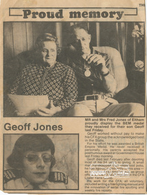
Document - Folder, Jones, 1979
Fred, Gwenda and Geoff Jones Contents 1. Proud memory; Geoff Jones, Diamond Valley News, 21 Nov 1979 2. Sudden death of 'much loved man', Diamond Valley News, 13 Feb 1979 3. Honor for a community friend, Diamond Valley News, 8 March 1995 (On reverse, 'Diverse program to entice riders' about St Andrews Saddle Club and fgeatures a photo of Debbie Jones) Gwendoline (Gwenda) Grace Watson Davies, only daughter of Mr. William Watson Davies and Mrs. Grace Davies (nee Hayes) of Arthur Street, Eltham was born in Newport, 18 February 1908. Gwenda grew up in Arthur Street and when she left school she was employed as an officer at the State Bank of Victoria, Chief Accountants Department, Head Office, Elizabeth Street, Melbourne. On October 20, 1937 after ten years of service, Gwenda submitted her letter of resignation effective November 26th as she was to be married in the near future to Fred Jones. Frederick Geoffrey Jones, born 7 January 1911, third son of Mr. and Mrs. W. Jones of Napoleon Street, Eltham, married Gwenda at the Eltham Methodist Church on 27 November 1937. They made their home at ‘Llangollen’, Arthur Street, Eltham, a new house Fred had constructed earlier that year opposite the Shire Offices. Their residence was recorded in the Electoral Rolls from 1963-1980 as 6 Arthur Street, Eltham which was situated on the corner of Arthur Street and present-day Commercial Place. In the 1970s their home was sold and demolished to make way for the new shops. They built a new home at the top of the hill in Bible Street. In the Electoral Rolls for 1943-1980, Frederick’s occupation was recorded as a Plumber’s Assistant. Fred was also a long-standing member of the Eltham Cemetery Trust. He was first appointed 26 April 1944 and resigned 17 July 1957 to be appointed to the Warringal and Eltham Joint Trust where he served till February 1980. He then re-joined the Eltham Cemetery Trust and served a further 14 years till his resignation on 24 August 1994. In total, Fred represented the interests of Eltham Cemetery for 50 years (1944-1994). Gwenda and Fred were blessed with a son, Frederick William Jones in March 1942. Sadly, Frederick only lived two days and was buried at Eltham Cemetery on March 11. It is not known whether his grave is marked. A second son, Geoffrey Morris Jones arrived 25 November 1944 but he sadly contracted polio as a child. A fall down the front steps of Fred and Gwenda’s new home in Bible Street culminated in Geoff’s death from a heart attack whilst in transit to the Austin Hospital on February 6, 1979, at age 34. He was also interred in the Eltham Cemetery. Geoff was posthumously awarded the British Empire Medal for his services to fire safety at the CFA. A small man, handicapped from his childhood polio, he had figured prominently in the area as an active Apex member and as group officer for the 13 local brigades in the CFA Lower Yarra Group. His work for the CFA, all voluntary, included writing a fire-fighting manual and the innovation of aerial fire spotting and weekly fire reports. Gwendoline and Fred were presented with Geoff’s B.EM. award at Government House. Four years later on the anniversary of Geoff’s death, Gwenda could not sleep and collapsed in the hallway at home from a heart attack, 6 February 1983 at age 74. She was interred with her son Geoff, at Eltham Cemetery on February 9th. Fred died 31 July 1997 at age 86 and was also interred at Eltham Cemetery. A memorial plaque to Gwenda, Fred and Geoff lies within the lawn cemetery at Eltham Cemetery.Newsprint clippingscfa, eltham cemetery, eltham cemetery trust, frederick geoffrey jones, geoffrey morris jones b.e.m., gwendoline grace watson jones (nee davies), lower yarra group, debbie jones, st andrews saddle club -
 Eltham District Historical Society Inc
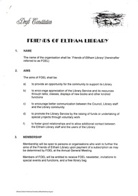
Folder, Friends of Eltham Library, 1988-1995
Folder of information relating to the library dates from 1988 to 1995 (before during and after construction of current Eltham Library located in Panther Place, Eltham). Folder includes record of meeting 15 October 1995 to relaunch FOEL. Includes plans of the library and draft constitution Bank account information. Selection of material re planning for new library including: Shire of Eltham Eltham Library Occasional committee agenda, Adult Literacy Group background; consultation progress. 1988-89. Newspaper article The aims of the community group are to (in summary) provide an opportunity for the community to support its library. To encourage appreciation of the library service and its resources. To encourage better communication between council, library staff and the community, to promote the library by raising funds and undertaking special projects and to foster good relationships. Also 15 page written submission prepapred on behalf of the Council of the Shire of Eltham and hand written notes by Harry Gilham in a folder. Submission to Administrative Appeals Tribunal of Victoria. Appeal on behalf of the Council of the Shire of Eltham supporting issuance of Permit, by Maddock Lonie and Chisholm, 21 January 1993. The submission includes discussion of the application, the subject land and the surrounding area, the proposed development, the planning controls, the objections, comments from referral authorities, the appeals, council's commitment to the projectand discussion of the issues raised.HG Booklets 2, 6 and 49.eltham library, friends of eltham library, community group, eltham adult literacy group inc., harry gilham collection -
 Eltham District Historical Society Inc
Photograph, Hume and Hovell passed here at Seymour 28 Oct 1824, Spring Excursion, Hume and Hovell's 1824 expedition (Part 2), 26 October 1997, 26/10/1997
[article by Diana Bassett-Smith in EDHS Newsletter No. 117, November 1997:] MONUMENT HUNTING THE HUME AND HOVELL WAY - Sunday October 26 1997 dawned bright and very warm. Some twenty-five members, complete with picnic baskets, met outside the Eltham Library awaiting the Cobb and Co. large coach which would be taking us on the second leg of our travels along the route of the early explorers Hume and Hovell. Stephen West was our very good driver for the day. He would be guided around the circuitous route by Russell Yeoman who had made a detailed study, not only of the intended route, but of the story of these two explorers. During the trip Russell regaled us with poetry, quotations from the Journals and the History of the Shire of Seymour, "The New Crossing Place" by Martindale, 1982, (now Mitchell Shire due to the recent amalgamations). We headed towards the Hume Highway via Greensborough and Cooper Street and proceeded north to our first stop, noting on the way Monument Hill in the distance which is near Kilmore and, according to Russell, well worth the effort to visit as the view across the valley is magnificent. Past Sunday Creek Valley, Mt Piper and Mt Disappointment, all traversed and noted and named by them. We passed through Tallarook, then onto Seymour where we took photos of the monument telling us that Hume and Hovell had passed through on the 28th of October 1824. We also deviated down Hume and Hovell Road viewing deer and emu farming and the Bellbourie property now a sanctuary. Leaving Seymour behind we travelled up the Avenel Road to the Avenel monument, pyramidal in design of four reducing square blocks with a sharply pointed peak, erected in 1924 in memory of the 1824 exploration. The day was warming up and the countryside showing the dryness of the current drought. A parallel note had been made in their journal too of 1824 of the drought appearance of the country they were traversing. At Seven Creeks, Euroa we stopped for some minutes to check the monument placed 20th November 1924 to commemorate their passage on the 29th December 1824. More photos. Russell had pointed out the abrupt termination of the distant ranges which is noted in their journal. The next monument is beside the road at the entrance to Honey Suckle Creek Caravan Park, Violet Town. The squarish shaped monument some eight feet high is topped with a simple steel cross, and was to mark the date of 28th December 1824 and built for the 20th November 1924. By now it was 12.20 and nearly lunchtime as we drove along the Warranbayne Road to Roach's Road, monument hunting without success. Though there is a large, what appears to be an old timber sign which was hard to read, maybe this was the lost monument. In many of the paddocks hay had been cut and baled or was being cut, what a contrast to the rugged country they had passed through which was smoky from the fires of the natives burning off. By 1.00 pm we were at Benalla and pulled up beside the park where abundant beds of roses filled the air with their scent and the smell of barbecued food twitched the nostrils whilst the cheerful sounds of other picnickers could be heard throughout the park. We left the bus and collected up our picnics, dispersed to the various tables and enjoyed the shade from the various European trees. 2.00 pm and we were on the road again driving along the Benalla, Mansfield, Yea road. The Swanpool monument states that they passed four miles south and returned three miles north. Then we stopped at the Barjarg monument which notes that they camped near this spot. It is again a pyramidal monument and this time topped with a steel arrow indicating their route of the 29th November 1824. Half an hour later we came to another monument, again with a steel arrow marker on top and the plaque dated the 2nd of 12th 1824. Erected on the 12th of 12th 1924. "They blazed the way that we might inherit the land." Another square based and needle topped monument appeared at Yarck near Yea and this plaque records the date of 3 December 1824. Near McGuigans Road Russell related that the expedition had lost a dog but it had found them next day, the dog was apparently torn by a kangaroo. A short while later Russell reminded us here of the problems they encountered in crossing the Goulburn River near Molesworth where banks were high, water deep and wide. "Good coat of grass but quite dry due to drought". At Yea we stopped for afternoon tea and raided the last of our picnics and looked at the monument to their journey of 1824, situated at a corner of the gardens near the bowling green. No photo – we were out of film. We returned home via Kinglake West and Whittlesea past the Yan Yean Reservoir, not full. 5.00 pm back at Eltham we emptied out of the bus and everyone, including Joan Cole, collected their things, Joan also had the major souvenir of the day, a large carp she had picked up from the river bank, her cat was in for a great feast. The day was made so interesting by the informed commentary which Russell provided. His background knowledge of the route and nature of the journey could only have come from many hours of reading and driving the area. Thank you to Russell and to everyone who made the day so informative and pleasurable. Colour photographactivities, hume and hovell, monument, seymour -
 Eltham District Historical Society Inc
Photograph, Spring Excursion, Hume and Hovell's 1824 expedition (Part 2), 26 October 1997, 26/10/1997
[article by Diana Bassett-Smith in EDHS Newsletter No. 117, November 1997:] MONUMENT HUNTING THE HUME AND HOVELL WAY - Sunday October 26 1997 dawned bright and very warm. Some twenty-five members, complete with picnic baskets, met outside the Eltham Library awaiting the Cobb and Co. large coach which would be taking us on the second leg of our travels along the route of the early explorers Hume and Hovell. Stephen West was our very good driver for the day. He would be guided around the circuitous route by Russell Yeoman who had made a detailed study, not only of the intended route, but of the story of these two explorers. During the trip Russell regaled us with poetry, quotations from the Journals and the History of the Shire of Seymour, "The New Crossing Place" by Martindale, 1982, (now Mitchell Shire due to the recent amalgamations). We headed towards the Hume Highway via Greensborough and Cooper Street and proceeded north to our first stop, noting on the way Monument Hill in the distance which is near Kilmore and, according to Russell, well worth the effort to visit as the view across the valley is magnificent. Past Sunday Creek Valley, Mt Piper and Mt Disappointment, all traversed and noted and named by them. We passed through Tallarook, then onto Seymour where we took photos of the monument telling us that Hume and Hovell had passed through on the 28th of October 1824. We also deviated down Hume and Hovell Road viewing deer and emu farming and the Bellbourie property now a sanctuary. Leaving Seymour behind we travelled up the Avenel Road to the Avenel monument, pyramidal in design of four reducing square blocks with a sharply pointed peak, erected in 1924 in memory of the 1824 exploration. The day was warming up and the countryside showing the dryness of the current drought. A parallel note had been made in their journal too of 1824 of the drought appearance of the country they were traversing. At Seven Creeks, Euroa we stopped for some minutes to check the monument placed 20th November 1924 to commemorate their passage on the 29th December 1824. More photos. Russell had pointed out the abrupt termination of the distant ranges which is noted in their journal. The next monument is beside the road at the entrance to Honey Suckle Creek Caravan Park, Violet Town. The squarish shaped monument some eight feet high is topped with a simple steel cross, and was to mark the date of 28th December 1824 and built for the 20th November 1924. By now it was 12.20 and nearly lunchtime as we drove along the Warranbayne Road to Roach's Road, monument hunting without success. Though there is a large, what appears to be an old timber sign which was hard to read, maybe this was the lost monument. In many of the paddocks hay had been cut and baled or was being cut, what a contrast to the rugged country they had passed through which was smoky from the fires of the natives burning off. By 1.00 pm we were at Benalla and pulled up beside the park where abundant beds of roses filled the air with their scent and the smell of barbecued food twitched the nostrils whilst the cheerful sounds of other picnickers could be heard throughout the park. We left the bus and collected up our picnics, dispersed to the various tables and enjoyed the shade from the various European trees. 2.00 pm and we were on the road again driving along the Benalla, Mansfield, Yea road. The Swanpool monument states that they passed four miles south and returned three miles north. Then we stopped at the Barjarg monument which notes that they camped near this spot. It is again a pyramidal monument and this time topped with a steel arrow indicating their route of the 29th November 1824. Half an hour later we came to another monument, again with a steel arrow marker on top and the plaque dated the 2nd of 12th 1824. Erected on the 12th of 12th 1924. "They blazed the way that we might inherit the land." Another square based and needle topped monument appeared at Yarck near Yea and this plaque records the date of 3 December 1824. Near McGuigans Road Russell related that the expedition had lost a dog but it had found them next day, the dog was apparently torn by a kangaroo. A short while later Russell reminded us here of the problems they encountered in crossing the Goulburn River near Molesworth where banks were high, water deep and wide. "Good coat of grass but quite dry due to drought". At Yea we stopped for afternoon tea and raided the last of our picnics and looked at the monument to their journey of 1824, situated at a corner of the gardens near the bowling green. No photo – we were out of film. We returned home via Kinglake West and Whittlesea past the Yan Yean Reservoir, not full. 5.00 pm back at Eltham we emptied out of the bus and everyone, including Joan Cole, collected their things, Joan also had the major souvenir of the day, a large carp she had picked up from the river bank, her cat was in for a great feast. The day was made so interesting by the informed commentary which Russell provided. His background knowledge of the route and nature of the journey could only have come from many hours of reading and driving the area. Thank you to Russell and to everyone who made the day so informative and pleasurable. Colour photographactivities, hume and hovell, bridge -
Federation University Historical Collection
Book - Book - Scrapbook, Ballarat Institute of Advanced Education: Scrapbook of newspaper cutting, Book 3, July 1970 to December 1970
Newspaper cuttings relating to Ballarat Institute of Advanced Education. These are from various newspapers and include The Age, Ballarat Courier, The Australian, The Herald. The cuttings cover the period from 7 July 1970 to 12 December 1970. Book with yellow cover, front. Spiral bound.ballarat institute of advanced education, biae, employment advertisements, early school records found, council records from 1870 - 1893, john lynch wins stock exchange award, b r hames to deliver lecture at smb, death of a w steane, biae motor cycle club visit factory, mount helen campus of the future, visit from mt isa officer, centenary celebrations, peter hensley outstanding academic record 1969, rosslynne guymer, hill climb, repco gives $5000 to smb fund, ray woolard artist, mineral discoveries in australia, centenary prediction, centenary medallion, betty archdale to deliver fourth lecture, looking back on school history, e j tippett, threshold of the second century, e j barker, stanley white awarded csiro doctoral scholarship, tertiary colleges should be community centre, post-diploma course in malting and brewing, young geologists from broken hill, technical conference for ballarat, banks' gift, exhibition by students, rare rocks for biae, teachers' college at mt helen?, technical principals' association, miss n findley of emily mcpherson college, visiting heads admire facilities at biae, advisory council sets guidelines, smb plaque unveiled, $25000 to centenary appeal, national service exemption granted, technical schools disrupted by teachers' strike, bid for fourth university, librarian course advocated, smb appeal at $221000, centenary of technical education in australia, mt helen campus opening, centenary of great achievement, governments give $100000 to institute, student from last century, mrs o ratray, biae asked to train librarians, buninyong seek talks, problems of "background" in education, exhibition by jon crawley - potter, mr thompson's comment, art sake at school, 90 engineers at biae, ray woollard -
 Lara RSL Sub Branch
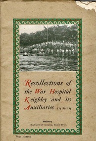
Booklet, Wadsworth & Company, Recollections of the War Hospital Keighley and its Auxiliaries 1916-19, circa 1920
Keighley War Hospital at Morton Banks was originally The Morton Banks Fever Hospital and after local funds were raised, extra wards were built to turn it into a War Hospital. It opened in time to take some of the first casualties from the Battle of the Somme in July 1916 and continued until the end of the war. The War Hospital Register archived at Keighley Library contains 13,214 names of servicemen who were treated there. It also contains the names of German prisoners of war who were being held locally and required treatment from time to time, notably from the influenza epidemic. Morton Banks had 746 beds. The book records the details of the hospital between 1916-19 including staff, hospital layout and departments, the Auxiliary Hospitals, Discipline, Recreation, Education, Comforts Committee and Affiliated Associations.Document of Military Hospital in Keighley, U.K. during WW1. Contains significant information on staff and different departments at the hospital.Carboard and paper booklet of 48 pages. The cover is beige with green border with black and red writing. Silverfish have eaten top right corner of cover.On front cover is publisher Wadsworth & Company, Russell Street, Keighley, (also known as Rydal Press) title and cost of Sixpence. Inside first blank page is written 'With kind regards from Willie To Jack'. 'Jack' refers to J.L.McIntyreworld war 1, ww1, military hospital, army hospital, keighley war hospital, morton banks, morton banks fever hospital, keighley -
 Bendigo Military Museum
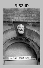
Photograph - Army Survey Regiment Personnel and Equipment, Fortuna, Bendigo, 1992
This collection of 15 photos of personnel and equipment was taken at the Army Survey Regiment, Fortuna, Bendigo, in 1992. The photos feature the inside Lithographic Squadron, external buildings, the transport compound, and the gardener’s end of the duty hut. Although these photos are not annotated most personnel are positively identified. Photos .14) to.15) feature Neil Morgan, who was a permanent ground maintenance employee.This is a set of 15 photographs of personnel and equipment at the Army Survey Regiment, Fortuna, Bendigo, 1992. The photographs are on 35mm negative film and were scanned at 96 dpi. They are part of the Army Survey Regiment’s Collection. .1) - Photo, black & white, 1992, outside Litho’s BARCRO work area (old entrance to Roman Bath) .2) - Photo, black & white, 1992, SPR Scott Cameron outside the Old OR’s Barracks. .3) - Photo, black & white, 1992, bank of the lake with Old & New OR’s Barracks. .4) - Photo, black & white, 1992, unidentified outside Q-Store buildings. .5)- Photo, black & white, 1992, records building under construction. .6) - Photo, black & white, 1992, ITEC type setter. .7) and .8) - Photo, black & white, 1992, ITEC type setter and IGX printer. .9) - Photo, black & white, 1992, IGX printer. .10) - Photo, black & white, 1992, Pakotone photographic processor. .11) - Photo, black & white, 1992, densitometer. .12) and .13) - Photo, black & white, 1992, unidentified RACT personnel in transport compound. .14) to.15) - Photo, black & white, 1992, Neil Morgan readying the ride-on lawn mower at rear end of Duty Hut. No personnel are identified.royal australian survey corps, rasvy, army survey regiment, army svy regt, fortuna, asr, litho -
 Bendigo Military Museum
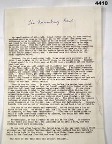
Document - ACCOUNT OF A WW2 BOMBING RAID, F.G. Davey, c. 1972
The document details F.G. Davey's eyewitness account of a raid on Nuremburg, Germany during WW2. On return from the raid the Lancaster Davey was piloting was damaged in an attack by a JU-88. See catalogue no. 4411P which shows the damage to the aircraft. Part of the F.G. Davey Collection. See 3536P for his service record.Single page document in black type on cream coloured foolscap sized paper. The text consists of seven paragraphs. The paper bears two watermarks each stating 'BURNIE BANK. MADE IN AUSTRALIA'.Heading handwritten in blue ink: 'The Nuremburg Raid'.bombing raids, f.g. davey, personal stories, raid on nuremburg -
 Federation University Historical Collection
Photograph - Colour, ANZAC Dawn Remembrance During the Covid-19 Pandemic, 2020, 25/04/2020
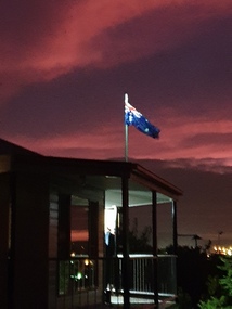
On 12 January, the World Health Organization (WHO) confirmed that a novel coronavirus was the cause of a respiratory illness in a cluster of people in Wuhan City, Hubei Province, China, who had initially come to the attention of the WHO on 31 December 2019. On 3 March, the Reserve Bank of Australia became the first central bank to cut interest rates in response to the outbreak. Official interest rates were cut by 0.25% (25 base points) to a record low of 0.5%. On 12 March, the Federal Government announced a A$17.6 billion stimulus package, the first since the 2008 GFC. he package consists of multiple parts, a one-off A$750 payment to around 6.5 million welfare recipients as early as 31 March 2020, small business assistance with 700,000 grants up to $25,000 and a 50% wage subsidy for 120,000 apprenticies or trainees for up to 9 months, 1 billion to support economically impacted sectors, regions and communities, and $700 million to increase tax write off and $3.2 billion to support short-term small and medium-sized business investment. On 16 March, Premier Dan Andrews and Minister for Health Jenny Mikakos declared a state of emergency for Victoria for at least four weeks. On 19 March, the Reserve Bank again cut interest rates by a further 0.25% to 0.25%, the lowest in Australian history. On 22 March, the government announced a second stimulus package of A$66bn, increasing the amount of total financial package offered to A$89bn. This included several new measures like doubling income support for individuals on Jobseeker's allowance, granting A$100,000 to small and medium-sized businesses and A$715 million to Australian airports and airlines. It also allowed individuals affected by the outbreak to access up to A$10,000 of their superannuation during 2019–2020 and also being able to take an additional same amount for the next year. on the same day Victorian Premier Daniel Andrews announced on 22 March that the state will bring the school holiday forwards to 24 March from 27 March. On 30 March, the Australian Federal Government announced a $130 billion "JobKeeper" wage subsidy program offering to pay employers up to $1500 a fortnight per full-time, part-time or casual employee that has worked for that business for over a year. For a business to be eligible, they must have lost 30% of turnover after 1 March of annual revenue up to and including $1 billion. For businesses with a revenue of over $1 billion, turnover must have decreased by 50%. Businesses are then required by law to pay the subsidy to their staff, in lieu of their usual wages. This response came after the enormous job losses seen just a week prior when an estimated 1 million Australians lost their jobs. This massive loss in jobs caused the myGov website to crash and lines out of Centrelink offices to run hundreds of metres long.The program was backdated to 1 March, to aim at reemploying the many people who had just lost their jobs in the weeks before. Businesses would receive the JobKeeper subsidy for six months. On 2 April, the number of cases in Victoria exceeded 1,000, including over 100 healthcare workers. On 5 April, New South Wales Police launched a criminal investigation into whether the operator of Ruby Princess, Carnival Australia, broke the Biosecurity Act 2015 (Cwth) and New South Wales state laws, by deliberately concealing COVID-19 cases. On 6 April, the Department of Health revealed that 2,432 people recovered from the infection as the federal government started reporting recovery statistics. This is more than a third from the official number reported so far, Deputy Chief Medical Officer Professor Paul Kelly stating, "I think it is important. Firstly it really reinforces that message, which is a true one, that most people who get this disease do recover”. The day before, at 3pm, it was announced that 2,315 of the 5,687 confirmed coronavirus cases had recovered. May 2020 - An outbreak in Victoria at a meatworks that was later revealed to be Cedar Meats was announced on 02 May with eight cases. By 8 May, the cluster of cases linked to Cedar Meats in Victoria was 71, consisting of at least 57 workers and 13 close contacts, including a nurse, aged care worker and high school student. The number had increased to 75 by 9 May, 88 by 13 May, and 90 by 14 May. On 9 May, two Victorian cases were announced to be related to McDonald's Fawkner. By 18 May, this had increased to 12 cases, and on that day it was revealed that a delivery driver had tested positive, prompting the closing for cleaning of 12 more McDonald's locations: Melton East, Laverton North, Yallambie, Taylors Lakes, Campbellfield, Sunbury, Hoppers Crossing, Riverdale Village, Sandown, Calder Highway Northbound/Outbound, Calder Highway Southbound/Inbound, and BP Rockbank Service Centre Outbound. On 15 May, South Australia became the second jurisdiction, after the ACT, to be free of any active cases, however on 26 May, a woman returning from overseas who was granted exemption into South Australia from her hotel quarantine in Victoria tested positive for COVID-19. This was the first new case in 19 days for the state.[101] On 4 June, it was announced that the woman had recovered and the state was free of any active cases once again.[102] On 17 May, Victoria announced two further business sites had been shut down due to a suspected case at each. Domino's Pizza in Fairfield has been shut for two weeks, and mattress manufacturer The Comfort Group in Deer Park was closed from Friday 15 May to at least Wednesday 20 May. On 6 June, both New South Wales and Victoria reported no new cases for the previous 24 hours, with only Queensland and Western Australia reporting one new case each, the lowest national total since February. Western Australia also announced two old cases. However, the new case in Queensland was linked to the Rydges on Swanston cluster in Melbourne when a man who travelled from Melbourne to Brisbane on Virgin flight VA313 on 1 June tested positive.Colour photographs of an ANZAC dawn remembrance from Armstrong Street South, Ballarat looking East towards Mount Warrenheip. Due to the Covid-19 Pandemic and associated social distancing requirements regular ANZAC Day services and marches could not be held. People were encouraged to remember from their driveways at dawn on 25 April 2020. covid-19, corona virus, pandemic, social distancing, anzac day driveway remembrance, dawn, australian flag, mount warrenheip -
 Federation University Historical Collection
Photograph - Colour, Federation University SMB Campus library Covid 19 Lockdown Notices, 2020, 23/04/2020
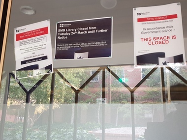
On 12 January, the World Health Organization (WHO) confirmed that a novel coronavirus was the cause of a respiratory illness in a cluster of people in Wuhan City, Hubei Province, China, who had initially come to the attention of the WHO on 31 December 2019. On 3 March, the Reserve Bank of Australia became the first central bank to cut interest rates in response to the outbreak. Official interest rates were cut by 0.25% (25 base points) to a record low of 0.5%. On 12 March, the Federal Government announced a A$17.6 billion stimulus package, the first since the 2008 GFC. he package consists of multiple parts, a one-off A$750 payment to around 6.5 million welfare recipients as early as 31 March 2020, small business assistance with 700,000 grants up to $25,000 and a 50% wage subsidy for 120,000 apprenticies or trainees for up to 9 months, 1 billion to support economically impacted sectors, regions and communities, and $700 million to increase tax write off and $3.2 billion to support short-term small and medium-sized business investment. On 16 March, Premier Dan Andrews and Minister for Health Jenny Mikakos declared a state of emergency for Victoria for at least four weeks. On 19 March, the Reserve Bank again cut interest rates by a further 0.25% to 0.25%, the lowest in Australian history. On 22 March, the government announced a second stimulus package of A$66bn, increasing the amount of total financial package offered to A$89bn. This included several new measures like doubling income support for individuals on Jobseeker's allowance, granting A$100,000 to small and medium-sized businesses and A$715 million to Australian airports and airlines. It also allowed individuals affected by the outbreak to access up to A$10,000 of their superannuation during 2019–2020 and also being able to take an additional same amount for the next year. on the same day Victorian Premier Daniel Andrews announced on 22 March that the state will bring the school holiday forwards to 24 March from 27 March. On 30 March, the Australian Federal Government announced a $130 billion "JobKeeper" wage subsidy program offering to pay employers up to $1500 a fortnight per full-time, part-time or casual employee that has worked for that business for over a year. For a business to be eligible, they must have lost 30% of turnover after 1 March of annual revenue up to and including $1 billion. For businesses with a revenue of over $1 billion, turnover must have decreased by 50%. Businesses are then required by law to pay the subsidy to their staff, in lieu of their usual wages. This response came after the enormous job losses seen just a week prior when an estimated 1 million Australians lost their jobs. This massive loss in jobs caused the myGov website to crash and lines out of Centrelink offices to run hundreds of metres long.The program was backdated to 1 March, to aim at reemploying the many people who had just lost their jobs in the weeks before. Businesses would receive the JobKeeper subsidy for six months. On 2 April, the number of cases in Victoria exceeded 1,000, including over 100 healthcare workers. On 5 April, New South Wales Police launched a criminal investigation into whether the operator of Ruby Princess, Carnival Australia, broke the Biosecurity Act 2015 (Cwth) and New South Wales state laws, by deliberately concealing COVID-19 cases. On 6 April, the Department of Health revealed that 2,432 people recovered from the infection as the federal government started reporting recovery statistics. This is more than a third from the official number reported so far, Deputy Chief Medical Officer Professor Paul Kelly stating, "I think it is important. Firstly it really reinforces that message, which is a true one, that most people who get this disease do recover”. The day before, at 3pm, it was announced that 2,315 of the 5,687 confirmed coronavirus cases had recovered. May 2020 - An outbreak in Victoria at a meatworks that was later revealed to be Cedar Meats was announced on 02 May with eight cases. By 8 May, the cluster of cases linked to Cedar Meats in Victoria was 71, consisting of at least 57 workers and 13 close contacts, including a nurse, aged care worker and high school student. The number had increased to 75 by 9 May, 88 by 13 May, and 90 by 14 May. On 9 May, two Victorian cases were announced to be related to McDonald's Fawkner. By 18 May, this had increased to 12 cases, and on that day it was revealed that a delivery driver had tested positive, prompting the closing for cleaning of 12 more McDonald's locations: Melton East, Laverton North, Yallambie, Taylors Lakes, Campbellfield, Sunbury, Hoppers Crossing, Riverdale Village, Sandown, Calder Highway Northbound/Outbound, Calder Highway Southbound/Inbound, and BP Rockbank Service Centre Outbound. On 15 May, South Australia became the second jurisdiction, after the ACT, to be free of any active cases, however on 26 May, a woman returning from overseas who was granted exemption into South Australia from her hotel quarantine in Victoria tested positive for COVID-19. This was the first new case in 19 days for the state.[101] On 4 June, it was announced that the woman had recovered and the state was free of any active cases once again.[102] On 17 May, Victoria announced two further business sites had been shut down due to a suspected case at each. Domino's Pizza in Fairfield has been shut for two weeks, and mattress manufacturer The Comfort Group in Deer Park was closed from Friday 15 May to at least Wednesday 20 May. On 6 June, both New South Wales and Victoria reported no new cases for the previous 24 hours, with only Queensland and Western Australia reporting one new case each, the lowest national total since February. Western Australia also announced two old cases. However, the new case in Queensland was linked to the Rydges on Swanston cluster in Melbourne when a man who travelled from Melbourne to Brisbane on Virgin flight VA313 on 1 June tested positive.Colour photographs of closure signs on the E.J Tippett Library due to the Covid-19 Pandemic and associated lock down and social distancing requirements.covid-19, corona virus, pandemic, social distancing, ballarat school of mines, e.j. tippett library, lock down -
 Federation University Historical Collection
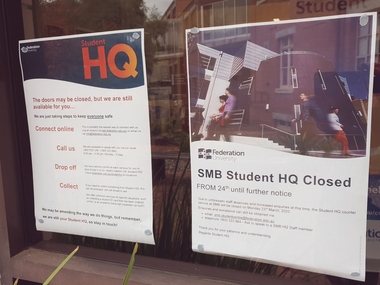
Photograph - Colour, Federation University SMB Campus Student HQ Covid 19 Closure Notices, 2020, 23/04/2020
On 12 January, the World Health Organization (WHO) confirmed that a novel coronavirus was the cause of a respiratory illness in a cluster of people in Wuhan City, Hubei Province, China, who had initially come to the attention of the WHO on 31 December 2019. On 3 March, the Reserve Bank of Australia became the first central bank to cut interest rates in response to the outbreak. Official interest rates were cut by 0.25% (25 base points) to a record low of 0.5%. On 12 March, the Federal Government announced a A$17.6 billion stimulus package, the first since the 2008 GFC. he package consists of multiple parts, a one-off A$750 payment to around 6.5 million welfare recipients as early as 31 March 2020, small business assistance with 700,000 grants up to $25,000 and a 50% wage subsidy for 120,000 apprenticies or trainees for up to 9 months, 1 billion to support economically impacted sectors, regions and communities, and $700 million to increase tax write off and $3.2 billion to support short-term small and medium-sized business investment. On 16 March, Premier Dan Andrews and Minister for Health Jenny Mikakos declared a state of emergency for Victoria for at least four weeks. On 19 March, the Reserve Bank again cut interest rates by a further 0.25% to 0.25%, the lowest in Australian history. On 22 March, the government announced a second stimulus package of A$66bn, increasing the amount of total financial package offered to A$89bn. This included several new measures like doubling income support for individuals on Jobseeker's allowance, granting A$100,000 to small and medium-sized businesses and A$715 million to Australian airports and airlines. It also allowed individuals affected by the outbreak to access up to A$10,000 of their superannuation during 2019–2020 and also being able to take an additional same amount for the next year. on the same day Victorian Premier Daniel Andrews announced on 22 March that the state will bring the school holiday forwards to 24 March from 27 March. On 30 March, the Australian Federal Government announced a $130 billion "JobKeeper" wage subsidy program offering to pay employers up to $1500 a fortnight per full-time, part-time or casual employee that has worked for that business for over a year. For a business to be eligible, they must have lost 30% of turnover after 1 March of annual revenue up to and including $1 billion. For businesses with a revenue of over $1 billion, turnover must have decreased by 50%. Businesses are then required by law to pay the subsidy to their staff, in lieu of their usual wages. This response came after the enormous job losses seen just a week prior when an estimated 1 million Australians lost their jobs. This massive loss in jobs caused the myGov website to crash and lines out of Centrelink offices to run hundreds of metres long.The program was backdated to 1 March, to aim at reemploying the many people who had just lost their jobs in the weeks before. Businesses would receive the JobKeeper subsidy for six months. On 2 April, the number of cases in Victoria exceeded 1,000, including over 100 healthcare workers. On 5 April, New South Wales Police launched a criminal investigation into whether the operator of Ruby Princess, Carnival Australia, broke the Biosecurity Act 2015 (Cwth) and New South Wales state laws, by deliberately concealing COVID-19 cases. On 6 April, the Department of Health revealed that 2,432 people recovered from the infection as the federal government started reporting recovery statistics. This is more than a third from the official number reported so far, Deputy Chief Medical Officer Professor Paul Kelly stating, "I think it is important. Firstly it really reinforces that message, which is a true one, that most people who get this disease do recover”. The day before, at 3pm, it was announced that 2,315 of the 5,687 confirmed coronavirus cases had recovered. May 2020 - An outbreak in Victoria at a meatworks that was later revealed to be Cedar Meats was announced on 02 May with eight cases. By 8 May, the cluster of cases linked to Cedar Meats in Victoria was 71, consisting of at least 57 workers and 13 close contacts, including a nurse, aged care worker and high school student. The number had increased to 75 by 9 May, 88 by 13 May, and 90 by 14 May. On 9 May, two Victorian cases were announced to be related to McDonald's Fawkner. By 18 May, this had increased to 12 cases, and on that day it was revealed that a delivery driver had tested positive, prompting the closing for cleaning of 12 more McDonald's locations: Melton East, Laverton North, Yallambie, Taylors Lakes, Campbellfield, Sunbury, Hoppers Crossing, Riverdale Village, Sandown, Calder Highway Northbound/Outbound, Calder Highway Southbound/Inbound, and BP Rockbank Service Centre Outbound. On 15 May, South Australia became the second jurisdiction, after the ACT, to be free of any active cases, however on 26 May, a woman returning from overseas who was granted exemption into South Australia from her hotel quarantine in Victoria tested positive for COVID-19. This was the first new case in 19 days for the state.[101] On 4 June, it was announced that the woman had recovered and the state was free of any active cases once again.[102] On 17 May, Victoria announced two further business sites had been shut down due to a suspected case at each. Domino's Pizza in Fairfield has been shut for two weeks, and mattress manufacturer The Comfort Group in Deer Park was closed from Friday 15 May to at least Wednesday 20 May. On 6 June, both New South Wales and Victoria reported no new cases for the previous 24 hours, with only Queensland and Western Australia reporting one new case each, the lowest national total since February. Western Australia also announced two old cases. However, the new case in Queensland was linked to the Rydges on Swanston cluster in Melbourne when a man who travelled from Melbourne to Brisbane on Virgin flight VA313 on 1 June tested positive.Colour photographs of closure signs on the E.J Tippett Library due to the Covid-19 Pandemic and associated lock down and social distancing requirements.covid-19, corona virus, pandemic, social distancing, ballarat school of mines, e.j. tippett library, lock down -
Federation University Historical Collection
Document - Documents, Federation University Notifications Referring to Covid-19, 2020, 06/04/2020
On 12 January, the World Health Organization (WHO) confirmed that a novel coronavirus was the cause of a respiratory illness in a cluster of people in Wuhan City, Hubei Province, China, who had initially come to the attention of the WHO on 31 December 2019. On 3 March, the Reserve Bank of Australia became the first central bank to cut interest rates in response to the outbreak. Official interest rates were cut by 0.25% (25 base points) to a record low of 0.5%. On 12 March, the Federal Government announced a A$17.6 billion stimulus package, the first since the 2008 GFC. he package consists of multiple parts, a one-off A$750 payment to around 6.5 million welfare recipients as early as 31 March 2020, small business assistance with 700,000 grants up to $25,000 and a 50% wage subsidy for 120,000 apprenticies or trainees for up to 9 months, 1 billion to support economically impacted sectors, regions and communities, and $700 million to increase tax write off and $3.2 billion to support short-term small and medium-sized business investment. On 16 March, Premier Dan Andrews and Minister for Health Jenny Mikakos declared a state of emergency for Victoria for at least four weeks. On 19 March, the Reserve Bank again cut interest rates by a further 0.25% to 0.25%, the lowest in Australian history. On 22 March, the government announced a second stimulus package of A$66bn, increasing the amount of total financial package offered to A$89bn. This included several new measures like doubling income support for individuals on Jobseeker's allowance, granting A$100,000 to small and medium-sized businesses and A$715 million to Australian airports and airlines. It also allowed individuals affected by the outbreak to access up to A$10,000 of their superannuation during 2019–2020 and also being able to take an additional same amount for the next year. on the same day Victorian Premier Daniel Andrews announced on 22 March that the state will bring the school holiday forwards to 24 March from 27 March. On 30 March, the Australian Federal Government announced a $130 billion "JobKeeper" wage subsidy program offering to pay employers up to $1500 a fortnight per full-time, part-time or casual employee that has worked for that business for over a year. For a business to be eligible, they must have lost 30% of turnover after 1 March of annual revenue up to and including $1 billion. For businesses with a revenue of over $1 billion, turnover must have decreased by 50%. Businesses are then required by law to pay the subsidy to their staff, in lieu of their usual wages. This response came after the enormous job losses seen just a week prior when an estimated 1 million Australians lost their jobs. This massive loss in jobs caused the myGov website to crash and lines out of Centrelink offices to run hundreds of metres long.The program was backdated to 1 March, to aim at reemploying the many people who had just lost their jobs in the weeks before. Businesses would receive the JobKeeper subsidy for six months. On 2 April, the number of cases in Victoria exceeded 1,000, including over 100 healthcare workers. On 5 April, New South Wales Police launched a criminal investigation into whether the operator of Ruby Princess, Carnival Australia, broke the Biosecurity Act 2015 (Cwth) and New South Wales state laws, by deliberately concealing COVID-19 cases. On 6 April, the Department of Health revealed that 2,432 people recovered from the infection as the federal government started reporting recovery statistics. This is more than a third from the official number reported so far, Deputy Chief Medical Officer Professor Paul Kelly stating, "I think it is important. Firstly it really reinforces that message, which is a true one, that most people who get this disease do recover”. The day before, at 3pm, it was announced that 2,315 of the 5,687 confirmed coronavirus cases had recovered. May 2020 - An outbreak in Victoria at a meatworks that was later revealed to be Cedar Meats was announced on 02 May with eight cases. By 8 May, the cluster of cases linked to Cedar Meats in Victoria was 71, consisting of at least 57 workers and 13 close contacts, including a nurse, aged care worker and high school student. The number had increased to 75 by 9 May, 88 by 13 May, and 90 by 14 May. On 9 May, two Victorian cases were announced to be related to McDonald's Fawkner. By 18 May, this had increased to 12 cases, and on that day it was revealed that a delivery driver had tested positive, prompting the closing for cleaning of 12 more McDonald's locations: Melton East, Laverton North, Yallambie, Taylors Lakes, Campbellfield, Sunbury, Hoppers Crossing, Riverdale Village, Sandown, Calder Highway Northbound/Outbound, Calder Highway Southbound/Inbound, and BP Rockbank Service Centre Outbound. On 15 May, South Australia became the second jurisdiction, after the ACT, to be free of any active cases, however on 26 May, a woman returning from overseas who was granted exemption into South Australia from her hotel quarantine in Victoria tested positive for COVID-19. This was the first new case in 19 days for the state.[101] On 4 June, it was announced that the woman had recovered and the state was free of any active cases once again.[102] On 17 May, Victoria announced two further business sites had been shut down due to a suspected case at each. Domino's Pizza in Fairfield has been shut for two weeks, and mattress manufacturer The Comfort Group in Deer Park was closed from Friday 15 May to at least Wednesday 20 May. On 6 June, both New South Wales and Victoria reported no new cases for the previous 24 hours, with only Queensland and Western Australia reporting one new case each, the lowest national total since February. Western Australia also announced two old cases. However, the new case in Queensland was linked to the Rydges on Swanston cluster in Melbourne when a man who travelled from Melbourne to Brisbane on Virgin flight VA313 on 1 June tested positive.Notifications to staff and students relating to the worldwide Covid-19 Pandemic. * Federation University COVIDSafe Plan prepared by the Transition to Campus Control Group, Version 1.4, 21 July 2020 * Federation University Notifications Referring to Covid-19, 18 August 2020covid-19, corona virus, pandemic, social distancing, lock down, federation university australia, covidsafe plan -
 Bendigo Military Museum
Financial record - CHEQUE BOOK, Commonwealth Bank of Australia, c.WWII
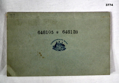
... Reg No 3536P for his service details. Banks cheques books ...Item re Frederick Gardner DAVEY DFC No 410533 RAAF. Refer Reg No 3536P for his service details.Commonwealth Bank of Australia cheque book from the Strand Branch, Australia House, London. Cover is grey card. Each cheque is printed in red ink on cream paper. 5 cheque stubs detail used cheques. Printed in black on cover: 648105 to 648128 In blue ink on cover: CBA Coat of Arms Handwritten in black ink: Details of recipients details issued & amountsbanks, cheques, books -
 Bendigo Military Museum
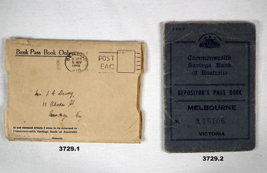
Financial record - PASSBOOK, c.WWII
Passbook covered Military & RAAF payments between 1942 & 1943. Item re Frederick Gardner DAVEY DFC No 410533 RAAF. Refer Reg No 3536P for his service details..1) Cream paper envelope which covered a bank passbook. .2) Blue buckram bank passbook. 20 cut edge pages. Pages contain details of banking transactions. Instructions for use & notices printed on end papers, first & last pages are on back cover..1) In centre in black ink: Bendigo post mark stamp. In centre handwritten address in black ink: Mr F G Davey 88 Olinda St Bendigo Vic On back: Commonwealth Savings Bank coat of arms. .2) Stamped on front: M15106 Handwritten in black ink on pages 2 & 3: Frederick Gardner Davey Remaining pages have handwritten transaction details & date savings.banks, military payments, raaf -
 Federation University Historical Collection
Photograph - Photograph - Colour, Social Distancing Signs during the Covid-19 Pandemic, 2020, 06/04/2020
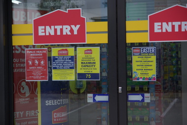
On 12 January, the World Health Organization (WHO) confirmed that a novel coronavirus was the cause of a respiratory illness in a cluster of people in Wuhan City, Hubei Province, China, who had initially come to the attention of the WHO on 31 December 2019. On 3 March, the Reserve Bank of Australia became the first central bank to cut interest rates in response to the outbreak. Official interest rates were cut by 0.25% (25 base points) to a record low of 0.5%. On 12 March, the Federal Government announced a A$17.6 billion stimulus package, the first since the 2008 GFC. he package consists of multiple parts, a one-off A$750 payment to around 6.5 million welfare recipients as early as 31 March 2020, small business assistance with 700,000 grants up to $25,000 and a 50% wage subsidy for 120,000 apprenticies or trainees for up to 9 months, 1 billion to support economically impacted sectors, regions and communities, and $700 million to increase tax write off and $3.2 billion to support short-term small and medium-sized business investment. On 16 March, Premier Dan Andrews and Minister for Health Jenny Mikakos declared a state of emergency for Victoria for at least four weeks. On 19 March, the Reserve Bank again cut interest rates by a further 0.25% to 0.25%, the lowest in Australian history. On 22 March, the government announced a second stimulus package of A$66bn, increasing the amount of total financial package offered to A$89bn. This included several new measures like doubling income support for individuals on Jobseeker's allowance, granting A$100,000 to small and medium-sized businesses and A$715 million to Australian airports and airlines. It also allowed individuals affected by the outbreak to access up to A$10,000 of their superannuation during 2019–2020 and also being able to take an additional same amount for the next year. on the same day Victorian Premier Daniel Andrews announced on 22 March that the state will bring the school holiday forwards to 24 March from 27 March. On 30 March, the Australian Federal Government announced a $130 billion "JobKeeper" wage subsidy program offering to pay employers up to $1500 a fortnight per full-time, part-time or casual employee that has worked for that business for over a year. For a business to be eligible, they must have lost 30% of turnover after 1 March of annual revenue up to and including $1 billion. For businesses with a revenue of over $1 billion, turnover must have decreased by 50%. Businesses are then required by law to pay the subsidy to their staff, in lieu of their usual wages. This response came after the enormous job losses seen just a week prior when an estimated 1 million Australians lost their jobs. This massive loss in jobs caused the myGov website to crash and lines out of Centrelink offices to run hundreds of metres long.The program was backdated to 1 March, to aim at reemploying the many people who had just lost their jobs in the weeks before. Businesses would receive the JobKeeper subsidy for six months. Victoria's "Second Wave" from Ballarat Courier, 05 August 2020 Wednesday, August 5: 725 cases, 15 deaths. A record figure reached yet again. Tuesday, August 4: 439 cases, 11 deaths. New fines introduced for COVID-infected people who aren't home. Monday, August 3: 429 cases, 13 deaths. Premier details mass industry shutdowns in Melbourne. Sunday, August 2: 671 cases, seven deaths as harsh new statewide lockdowns are announced Saturday, August 1: 397 new cases, three deaths Friday, July 31: 627 new cases, eight deaths. Premier says one in four Covid cases not home when checked. Thursday July 30: 723 cases, 13 deaths. Just when it was looking promising, alarming new record set. Wednesday July 29: 295 new cases, nine deaths as new cases drop below 300 for first time in nine days Tuesday July 28: 380 new cases, six deaths as aged care outbreaks continue to climb Monday July 27: 532 new cases as daily cases hits 500 for first time, six deaths Sunday July 26: 459 new cases as double-digit death toll is recorded for first time with 10 deaths Saturday July 25: 357 new cases, five new deaths Friday July 24: 300 cases, six deaths, ADF role expanded to help with contact tracing. Thursday July 23 - 403 cases, five deaths, worst day for fatalities in any state, masks now mandatory Wednesday July 22 - 484 cases, two deaths Tuesday July 21 - 374 cases, three deaths Monday July 20 - 275 cases, one death Sunday July 19 - 363 cases, three deaths, notice that masks will become mandatory in lockdown areas Saturday July 18 - 217 cases, three deaths, final Melbourne public housing tower released from hard lockdown Friday July 17 - 428 cases, three deaths Thursday July 16 - 317 cases, two deaths Wednesday July 15 - 238 cases, one death Tuesday July 14 - 270 cases, two deaths Monday July 13 - 177 cases Sunday July 12 - 273 cases, one death Saturday July 11 - 216 cases, one death Friday July 10 - 288 cases, a national daily record at the time Thursday July 9 - 165 cases, eight of nine Melbourne public housing towers released from hard lockdown Wednesday July 8 - 134 cases, new stage-three restrictions announced for metropolitan Melbourne and Mitchell Shire Tuesday July 7 - 191 cases Monday July 6 - 127 cases, two deaths, NSW border closed Sunday July 5 - 74 cases Saturday July 4 - 108 cases, immediate hard lockdown of nine Melbourne public housing towers Friday July 3 - 66 cases Thursday July 2 - 77 cases Wednesday July 1 - 73 casesColour photographs of social distancing signs during the Covid-19 Pandemic, on Chemist Warehouse in Sebastopol. On 06 April 2020 a maximum of 75 people were allowed in the chemist at one time, and those with syptoms of Covid-19 (fever, cough, shortness of breath) were asked to not enter without phone contact. Upon entering customers were directed to use hand sanitizer, and 1.5 metre markings were placed on the floor to enable legal social distancing.covid-19, corona virus, pandemic, chemist's warehouse, sebastopol, social distancing -
 Federation University Historical Collection
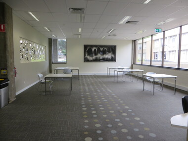
Photograph - Photograph - Colour, E.J. Barker Library Social Distancing During the Covid19 Pandemic, 2020, 06/04/2020
On 12 January, the World Health Organization (WHO) confirmed that a novel coronavirus was the cause of a respiratory illness in a cluster of people in Wuhan City, Hubei Province, China, who had initially come to the attention of the WHO on 31 December 2019. On 3 March, the Reserve Bank of Australia became the first central bank to cut interest rates in response to the outbreak. Official interest rates were cut by 0.25% (25 base points) to a record low of 0.5%. On 12 March, the Federal Government announced a A$17.6 billion stimulus package, the first since the 2008 GFC. he package consists of multiple parts, a one-off A$750 payment to around 6.5 million welfare recipients as early as 31 March 2020, small business assistance with 700,000 grants up to $25,000 and a 50% wage subsidy for 120,000 apprenticies or trainees for up to 9 months, 1 billion to support economically impacted sectors, regions and communities, and $700 million to increase tax write off and $3.2 billion to support short-term small and medium-sized business investment. On 16 March, Premier Dan Andrews and Minister for Health Jenny Mikakos declared a state of emergency for Victoria for at least four weeks. On 19 March, the Reserve Bank again cut interest rates by a further 0.25% to 0.25%, the lowest in Australian history. On 22 March, the government announced a second stimulus package of A$66bn, increasing the amount of total financial package offered to A$89bn. This included several new measures like doubling income support for individuals on Jobseeker's allowance, granting A$100,000 to small and medium-sized businesses and A$715 million to Australian airports and airlines. It also allowed individuals affected by the outbreak to access up to A$10,000 of their superannuation during 2019–2020 and also being able to take an additional same amount for the next year. on the same day Victorian Premier Daniel Andrews announced on 22 March that the state will bring the school holiday forwards to 24 March from 27 March. On 30 March, the Australian Federal Government announced a $130 billion "JobKeeper" wage subsidy program offering to pay employers up to $1500 a fortnight per full-time, part-time or casual employee that has worked for that business for over a year. For a business to be eligible, they must have lost 30% of turnover after 1 March of annual revenue up to and including $1 billion. For businesses with a revenue of over $1 billion, turnover must have decreased by 50%. Businesses are then required by law to pay the subsidy to their staff, in lieu of their usual wages. This response came after the enormous job losses seen just a week prior when an estimated 1 million Australians lost their jobs. This massive loss in jobs caused the myGov website to crash and lines out of Centrelink offices to run hundreds of metres long.The program was backdated to 1 March, to aim at reemploying the many people who had just lost their jobs in the weeks before. Businesses would receive the JobKeeper subsidy for six months.Colour photographs of furniture placed for social distancing in the Federation University E.J Barker Library during the Covid-19 Pandemic. The next day the library was closed all except staff.covid-19, corona virus, pandemic, library, e.j. barker library, mt helen library -
 Federation University Historical Collection
Photograph, Dana Street, Ballarat During Covid-19 State of Emergency, 13/04/2020
On 12 January, the World Health Organization (WHO) confirmed that a novel coronavirus was the cause of a respiratory illness in a cluster of people in Wuhan City, Hubei Province, China, who had initially come to the attention of the WHO on 31 December 2019. On 3 March, the Reserve Bank of Australia became the first central bank to cut interest rates in response to the outbreak. Official interest rates were cut by 0.25% (25 base points) to a record low of 0.5%. On 12 March, the Federal Government announced a A$17.6 billion stimulus package, the first since the 2008 GFC. he package consists of multiple parts, a one-off A$750 payment to around 6.5 million welfare recipients as early as 31 March 2020, small business assistance with 700,000 grants up to $25,000 and a 50% wage subsidy for 120,000 apprenticies or trainees for up to 9 months, 1 billion to support economically impacted sectors, regions and communities, and $700 million to increase tax write off and $3.2 billion to support short-term small and medium-sized business investment. On 16 March, Premier Dan Andrews and Minister for Health Jenny Mikakos declared a state of emergency for Victoria for at least four weeks. On 19 March, the Reserve Bank again cut interest rates by a further 0.25% to 0.25%, the lowest in Australian history. On 22 March, the government announced a second stimulus package of A$66bn, increasing the amount of total financial package offered to A$89bn. This included several new measures like doubling income support for individuals on Jobseeker's allowance, granting A$100,000 to small and medium-sized businesses and A$715 million to Australian airports and airlines. It also allowed individuals affected by the outbreak to access up to A$10,000 of their superannuation during 2019–2020 and also being able to take an additional same amount for the next year. on the same day Victorian Premier Daniel Andrews announced on 22 March that the state will bring the school holiday forwards to 24 March from 27 March. On 30 March, the Australian Federal Government announced a $130 billion "JobKeeper" wage subsidy program offering to pay employers up to $1500 a fortnight per full-time, part-time or casual employee that has worked for that business for over a year. For a business to be eligible, they must have lost 30% of turnover after 1 March of annual revenue up to and including $1 billion. For businesses with a revenue of over $1 billion, turnover must have decreased by 50%. Businesses are then required by law to pay the subsidy to their staff, in lieu of their usual wages. This response came after the enormous job losses seen just a week prior when an estimated 1 million Australians lost their jobs. This massive loss in jobs caused the myGov website to crash and lines out of Centrelink offices to run hundreds of metres long.The program was backdated to 1 March, to aim at reemploying the many people who had just lost their jobs in the weeks before. Businesses would receive the JobKeeper subsidy for six months. * On 12 April 2020 Victorian Premier Daniel Andrews Extended the State of Emergency until midnight on May 11. On this day the world has 1,604,900 cases of coronavirus, with 95,738 deaths. America has 468,887 cases of covid19, with 1,900 Americans dying in the last 24 hours. The UK has 65,077 cases. 881 people died in the last 24 hours. Australia has 6,292 cases. 58 people have died to date.Colour photographs of Ballarat's usually very busy Dana Street during Covid-19 Social Isoliation. The photographs were taken at 4.00pm. dana street, ballarat, covid19, corona virus, pandemic, state of emergency -
 Federation University Historical Collection
Photograph - Photograph - Colour, Eyre Street, Ballarat During Covid-19 State of Emergency, 13/04/2020
On 12 January, the World Health Organization (WHO) confirmed that a novel coronavirus was the cause of a respiratory illness in a cluster of people in Wuhan City, Hubei Province, China, who had initially come to the attention of the WHO on 31 December 2019. On 3 March, the Reserve Bank of Australia became the first central bank to cut interest rates in response to the outbreak. Official interest rates were cut by 0.25% (25 base points) to a record low of 0.5%. On 12 March, the Federal Government announced a A$17.6 billion stimulus package, the first since the 2008 GFC. he package consists of multiple parts, a one-off A$750 payment to around 6.5 million welfare recipients as early as 31 March 2020, small business assistance with 700,000 grants up to $25,000 and a 50% wage subsidy for 120,000 apprenticies or trainees for up to 9 months, 1 billion to support economically impacted sectors, regions and communities, and $700 million to increase tax write off and $3.2 billion to support short-term small and medium-sized business investment. On 16 March, Premier Dan Andrews and Minister for Health Jenny Mikakos declared a state of emergency for Victoria for at least four weeks. On 19 March, the Reserve Bank again cut interest rates by a further 0.25% to 0.25%, the lowest in Australian history. On 22 March, the government announced a second stimulus package of A$66bn, increasing the amount of total financial package offered to A$89bn. This included several new measures like doubling income support for individuals on Jobseeker's allowance, granting A$100,000 to small and medium-sized businesses and A$715 million to Australian airports and airlines. It also allowed individuals affected by the outbreak to access up to A$10,000 of their superannuation during 2019–2020 and also being able to take an additional same amount for the next year. on the same day Victorian Premier Daniel Andrews announced on 22 March that the state will bring the school holiday forwards to 24 March from 27 March. On 30 March, the Australian Federal Government announced a $130 billion "JobKeeper" wage subsidy program offering to pay employers up to $1500 a fortnight per full-time, part-time or casual employee that has worked for that business for over a year. For a business to be eligible, they must have lost 30% of turnover after 1 March of annual revenue up to and including $1 billion. For businesses with a revenue of over $1 billion, turnover must have decreased by 50%. Businesses are then required by law to pay the subsidy to their staff, in lieu of their usual wages. This response came after the enormous job losses seen just a week prior when an estimated 1 million Australians lost their jobs. This massive loss in jobs caused the myGov website to crash and lines out of Centrelink offices to run hundreds of metres long.The program was backdated to 1 March, to aim at reemploying the many people who had just lost their jobs in the weeks before. Businesses would receive the JobKeeper subsidy for six months. * On 12 April 2020 Victorian Premier Daniel Andrews Extended the State of Emergency until midnight on May 11. On this day the world has 1,604,900 cases of coronavirus, with 95,738 deaths. America has 468,887 cases of covid19, with 1,900 Americans dying in the last 24 hours. The UK has 65,077 cases. 881 people died in the last 24 hours. Australia has 6,292 cases. 58 people have died to date.Colour photographs of Ballarat's usually very busy Eyre Street during Covid-19 Social Isoliation. The photographs were taken at 4.00pm. ballarat, covid19, corona virus, pandemic, state of emergency, eyre street -
Federation University Historical Collection
Poster, Victorian Department of Health and Human Services, A number of Covid-19 Posters Produced by the Victorian Departent of Health and Human Services, 2021, 11/06/2021
On 12 January, the World Health Organization (WHO) confirmed that a novel coronavirus was the cause of a respiratory illness in a cluster of people in Wuhan City, Hubei Province, China, who had initially come to the attention of the WHO on 31 December 2019. On 3 March, the Reserve Bank of Australia became the first central bank to cut interest rates in response to the outbreak. Official interest rates were cut by 0.25% (25 base points) to a record low of 0.5%. On 12 March, the Federal Government announced a A$17.6 billion stimulus package, the first since the 2008 GFC. he package consists of multiple parts, a one-off A$750 payment to around 6.5 million welfare recipients as early as 31 March 2020, small business assistance with 700,000 grants up to $25,000 and a 50% wage subsidy for 120,000 apprenticies or trainees for up to 9 months, 1 billion to support economically impacted sectors, regions and communities, and $700 million to increase tax write off and $3.2 billion to support short-term small and medium-sized business investment. On 16 March, Premier Dan Andrews and Minister for Health Jenny Mikakos declared a state of emergency for Victoria for at least four weeks. On 19 March, the Reserve Bank again cut interest rates by a further 0.25% to 0.25%, the lowest in Australian history. On 22 March, the government announced a second stimulus package of A$66bn, increasing the amount of total financial package offered to A$89bn. This included several new measures like doubling income support for individuals on Jobseeker's allowance, granting A$100,000 to small and medium-sized businesses and A$715 million to Australian airports and airlines. It also allowed individuals affected by the outbreak to access up to A$10,000 of their superannuation during 2019–2020 and also being able to take an additional same amount for the next year. on the same day Victorian Premier Daniel Andrews announced on 22 March that the state will bring the school holiday forwards to 24 March from 27 March. On 30 March, the Australian Federal Government announced a $130 billion "JobKeeper" wage subsidy program offering to pay employers up to $1500 a fortnight per full-time, part-time or casual employee that has worked for that business for over a year. For a business to be eligible, they must have lost 30% of turnover after 1 March of annual revenue up to and including $1 billion. For businesses with a revenue of over $1 billion, turnover must have decreased by 50%. Businesses are then required by law to pay the subsidy to their staff, in lieu of their usual wages. This response came after the enormous job losses seen just a week prior when an estimated 1 million Australians lost their jobs. This massive loss in jobs caused the myGov website to crash and lines out of Centrelink offices to run hundreds of metres long.The program was backdated to 1 March, to aim at reemploying the many people who had just lost their jobs in the weeks before. Businesses would receive the JobKeeper subsidy for six months. Victoria's "Second Wave" from Ballarat Courier, 05 August 2020 Wednesday, August 5: 725 cases, 15 deaths. A record figure reached yet again. Tuesday, August 4: 439 cases, 11 deaths. New fines introduced for COVID-infected people who aren't home. Monday, August 3: 429 cases, 13 deaths. Premier details mass industry shutdowns in Melbourne. Sunday, August 2: 671 cases, seven deaths as harsh new statewide lockdowns are announced Saturday, August 1: 397 new cases, three deaths Friday, July 31: 627 new cases, eight deaths. Premier says one in four Covid cases not home when checked. Thursday July 30: 723 cases, 13 deaths. Just when it was looking promising, alarming new record set. Wednesday July 29: 295 new cases, nine deaths as new cases drop below 300 for first time in nine days Tuesday July 28: 380 new cases, six deaths as aged care outbreaks continue to climb Monday July 27: 532 new cases as daily cases hits 500 for first time, six deaths Sunday July 26: 459 new cases as double-digit death toll is recorded for first time with 10 deaths Saturday July 25: 357 new cases, five new deaths Friday July 24: 300 cases, six deaths, ADF role expanded to help with contact tracing. Thursday July 23 - 403 cases, five deaths, worst day for fatalities in any state, masks now mandatory Wednesday July 22 - 484 cases, two deaths Tuesday July 21 - 374 cases, three deaths Monday July 20 - 275 cases, one death Sunday July 19 - 363 cases, three deaths, notice that masks will become mandatory in lockdown areas Saturday July 18 - 217 cases, three deaths, final Melbourne public housing tower released from hard lockdown Friday July 17 - 428 cases, three deaths Thursday July 16 - 317 cases, two deaths Wednesday July 15 - 238 cases, one death Tuesday July 14 - 270 cases, two deaths Monday July 13 - 177 cases Sunday July 12 - 273 cases, one death Saturday July 11 - 216 cases, one death Friday July 10 - 288 cases, a national daily record at the time Thursday July 9 - 165 cases, eight of nine Melbourne public housing towers released from hard lockdown Wednesday July 8 - 134 cases, new stage-three restrictions announced for metropolitan Melbourne and Mitchell Shire Tuesday July 7 - 191 cases Monday July 6 - 127 cases, two deaths, NSW border closed Sunday July 5 - 74 cases Saturday July 4 - 108 cases, immediate hard lockdown of nine Melbourne public housing towers Friday July 3 - 66 cases Thursday July 2 - 77 cases Wednesday July 1 - 73 casesColour posters advising on safety measures for Victorian during the 2020-2021 Covid-19 Pandemic. The posters were made available by the Department of Health and Human Services and have been saved as PDFs, and printed off onot A4 paper.covid-19, corona virus, pandemic, posters, department of health and human services