Showing 84 items
matching bark hut
-
 The Beechworth Burke Museum Research Collection
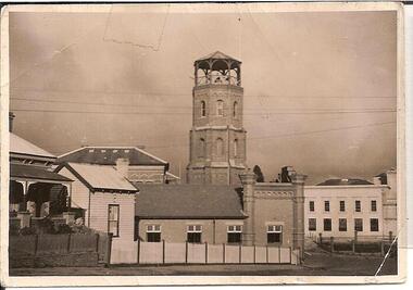
Card (Series) - Index Card, George Tibbits, Ford Street, Beechworth, 1976
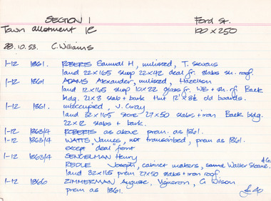
... ' slab & bark Hut 12'x8'6" old boards. 1-12 1861 unoccupied, J...' slab & bark Hut 12'x8'6" old boards. 1-12 1861 unoccupied, J ...George Tibbits, University of Melbourne. Faculty of Architecture, Building and Town & Regional PlanningIndex system that support the research for Beechworth : historical reconstruction / [by] George Tibbits ... [et al]Arranged by street names of BeechworthEach index card includes: street name and number of property, image of property, allotment and section number, property owners and dates of ownership, description of the property according to rate records, property floor plan with dimensions.beechworth, george tibbitsbeechworth, george tibbits -
 Bendigo Historical Society Inc.
Photograph - FARMHOUSE NEAR MT SUGARLOAF - SLAB HUT, c.1880
... Sepia photograph. Slab hut with bark roof, verandah. One.... Slab hut with bark roof, verandah. One brick chimney ...Sepia photograph. Slab hut with bark roof, verandah. One brick chimney, weatherboard skillion at L end. One male under verandah. One male in yard. One male mounted on horse. Barrels, wheelbarrow, four wheeled horse drawn vehicle under or near verandah. Inscriptions on front 'MP94', in red ballpoint ink '28'.On Back in grey lead 'Axedale family near Sugarloaf'.( near Fosterville ) On back in red ball point pen '28'. History of object: Previous Acc. No. 'MP 94'. An important photo of early settlers showing type and construction of farmhouse, type of farm implements and clothingBendigo Advertiserbuildings, residential, cottage -
 Eltham District Historical Society Inc
Photograph - Digital Photograph, Marguerite Marshall, Uniting Church, Main Road, Eltham, 19 August 2008
... Street. From 1855 the Wesleyans worshipped in a slab-and-bark hut... Street. From 1855 the Wesleyans worshipped in a slab-and-bark hut ...Eltham's original Wesleyan Methodist Church Covered under Heritage Overlay, Nillumbik Planning Scheme. Published: Nillumbik Now and Then / Marguerite Marshall 2008; photographs Alan King with Marguerite Marshall.; p97 The pretty Uniting Church building at the corner of John and Main Roads Eltham has served the community since 1881.1 Originally called the Eltham Wesleyan Church, the church became the Eltham Methodist Church in 1902, the year it united with the Primitive Methodists.2 As the church community developed, influencing and being influenced by the wider community, its buildings changed accordingly. Eltham Wesleyans first worshiped together in 1850 at the home of William and Mary Crozier on 24 acres (9.7ha) bounded by Mount Pleasant Road and Pitt Street. From 1855 the Wesleyans worshipped in a slab-and-bark hut; then in 1858 in a chapel on Henry Street close to Maria Street (now Main Road). Meanwhile, in 1860, the Primitive Methodists opened a brick chapel at the corner of Susan and Bridge Streets. The John Street building – in the Early English Gothic style with biochrome brick window frames, buttress heads and pinnacle – was designed by architects Crouch and Wilson. Church member George Stebbing built the church as he did Eltham’s St Margaret’s Anglican Church and Shillinglaw Cottage. The Church Honour Roll is a poignant reminder of how church members have served the wider community: 27 members enlisted and 11 died in World War One. Despite the Great Depression, 1931 was a time of expansion for the church. Its red-brick hall was opened by prominent Methodist and philanthropist F J Cato of the Moran and Cato Grocery chain. The hall enabled the church to attract people from outside through activities like its gymnasium – with 40 boys and youth participating – and the girls’ callisthenics club, which competed at the Ballarat South Street Competitions. The church also held concerts, bazaars, picnics and sports, with badminton and tennis played on the church court at 23 John Street. Two stained-glass windows commemorate tragic events. A dove representing the Holy Spirit and Comforter marked the death in 1936 of member Effie Lowerson from scarlet fever at 14 years. The other depicting the Biblical story A sower went forth to sow, commemorates Ross Gangell, who died in 1961 at 23 years of a rare blood condition. Eltham’s population expanson resulted in the growth of the church and an extension in 1971, designed by member and architect Colin Jones. The church was linked to the hall and additions included a foyer, vestry, meeting room and toilets. The design reflected the Eltham style of the time, with its simplicity, extensive clear glass, reused baked clay-bricks from the 1881 church, heavy ceiling beams and solomite (compressed straw) ceiling. On June 26, 1977 the church became part of the new Uniting Church in Australia consisting of the former Methodist and Congregational and most of the Presbyterian Churches. In 1981 membership peaked at 159 – about 20 years after most Protestant churches – and continued to reach out to the wider community.3 In 1987, 147 children attended Selihoo, the weekly after-school program organised with St Margaret’s Anglican Church. From 1993, the church with other local churches, participated in LINC (Love in the Name of Christ), helping the wider community in various ways including babysitting, transport, gardening and visiting. Despite such initiatives, church numbers declined, and on June 23, 1996, the church merged with the Montmorency Uniting Church.4 However, the church continued to proclaim its message of love in community service and strong social justice action, such as in Jubilee 2000, supporting debt relief to the world’s 45 poorest countries. Some of the many church members who have had an outstanding impact on the wider community include Philip Shillinglaw, farmer and poet, and Arthur Bird (after whom the Arthur Bird Reserve is named), a pioneer orchardist and the Sunday School Superintendent for 33 years. Others were: the Rev Dr Cliff Wright, who established the Methodist Youth Fellowship and was prominent in the World Council of Churches, the Rev Brian Howe, who became Deputy Prime Minister and Tim Marshall, awarded the Order of Australia in 2000 for his work on salinity.This collection of almost 130 photos about places and people within the Shire of Nillumbik, an urban and rural municipality in Melbourne's north, contributes to an understanding of the history of the Shire. Published in 2008 immediately prior to the Black Saturday bushfires of February 7, 2009, it documents sites that were impacted, and in some cases destroyed by the fires. It includes photographs taken especially for the publication, creating a unique time capsule representing the Shire in the early 21st century. It remains the most recent comprehenesive publication devoted to the Shire's history connecting local residents to the past. nillumbik now and then (marshall-king) collection, eltham uniting church, eltham methodist church -
 Eltham District Historical Society Inc
Photograph - Digital Photograph, Marguerite Marshall, Alan Marshall by Marcus Skipper (1995) outside Eltham Library, Panther Place, Eltham, 11 October 2006
... in Research, which had three bark huts. In one of these he wrote his... in Research, which had three bark huts. In one of these he wrote his ...Sculture in bronze of Alan Marshall by Marcus Skipper, 1995 Alan Marshall, AM., O.B.E., Hon.LL,D. (1902-1984) was born at Noorat, Victoria and became one of Australia's most famous authors. His association with the Eltham area began in 1920 when he started his first job as a junior clerk at the Eltham Shire Offices, Kangaroo Ground. In the 1940's he spent some time living at Research. From 1955 he lived in Eltham for nearly 20 years. Disabilities resulting from polio as a young child did not prevent a wide range of experiences. Alan's occupations have been listed as clerk, night watchman, fortune teller, freelance journalist and author. He has been patron of many disadvantaged Children's Societies. Alan's books are numerous and include novels, short stories, children's books, history and travel. Among the best known are his autobiographies "I Can Jump Puddles" and "This is the Grass". Others include "These are My People", "Ourselves Writ Strange", "People of the Dreamtime"; "The Gay Provider" and "Wild Red Horses". In 1971 he wrote the Centenary History of the Shire of Eltham, "Pioneers and Painters". Covered under National Trust of Australia (Victoria), State significance. Published: Nillumbik Now and Then / Marguerite Marshall 2008; photographs Alan King with Marguerite Marshall.; p159 Outside the Eltham Library a bronze figure of a short one-legged man with a crutch invites people to the world of literature. The bronze statue, by Marcus Skipper, is of author Alan Marshall, who is famed for his autobiography I Can Jump Puddles, about growing up and overcoming the effects of polio. That plucky little boy later lived in the Nillumbik district for more than 50 years, and on his death in 1984, was buried in the Nillumbik Cemetery at Diamond Creek. Although a hugely successful author, his grave is modest with only a tiny boulder and simple bronze plaque on a grassed plot. From 1955 to 1972 Marshall lived in a tiny fibro-cement bungalow at the rear of a house at Park West Road, Eltham, owned by his older sister, Elsie McConnell. It was there that he wrote most of his autobiographical trilogy and his history of the former Eltham Shire, Pioneers and Painters. His long association with Eltham Shire began in 1918 when his family moved to Diamond Creek. Then in 1920 he began work as a junior clerk at the Eltham Shire Offices on Main Road, Kangaroo Ground near the Yarra Glen Road, while boarding at the hotel next door. Marshall later bought a block of land in Research, which had three bark huts. In one of these he wrote his first book These Are My People. He later sold the land but lived in a caravan there and in 1955 wrote I Can Jump Puddles.1 Proud of its citizen, the Eltham Shire named a park after Marshall at the corner of Main Road and Leanne Drive, Eltham. In 1985 the Shire initiated the Alan Marshall Short Story Award. It was Marshall’s early life in the country that taught him to live courageously in spite of his crippling polio, and he inspired many. This informed his writing – full of courage, championing the battler and love of the bush. Alan Marshall was born in 1902 at Noorat in Western Victoria, as the only son of Billy a drover, horse breaker, hawker and then general store owner. At the age of six, Marshall contracted infantile paralysis and was later hospitalised in Colac for 18 months. With his father’s encouragement, Marshall learnt to swim, wrestle and box, ride a bicycle (downhill), ride a horse and drive a car. Marshall won a scholarship to Stott’s Correspondence College to study accountancy. To help him continue his studies and find employment, his family bought 12 acres (4.8ha), in Ryans Road, Diamond Creek, opposite Windmill Court. There they ran cows, some poultry and an orchard. But life with a disability and during the Depression was hard for Marshall, who for 20 years, endured long periods of unemployment and loneliness and was often exploited at work.2 However, life improved in the 1930s, when he published short stories and articles in newspapers and magazines, including a column of advice to the lovelorn, which he wrote for nearly 20 years. At age 42 Marshall published his first book and in the next 30 years he published more than 20. His most successful book was I Can Jump Puddles, which sold more than three million copies internationally. It was made into a film, released in 1971, by Czechoslovakian director Karel Kachyna. Marshall was one of the first Australians to write about Aborigines who called him Gurrawilla - teller of tales - when he lived with them in Arnhem Land for eight months.3 In 1941 Marshall married Olive Dixon, with whom he had two daughters, Catherine and Jennifer. Marshall and Olive divorced in 1957. In 1972 Marshall was awarded an OBE for his work with the handicapped. He was also awarded an Honorary Doctor of Laws by Melbourne University, an Order of Australia for services to literature and the Soviet Order of Friendship of Peoples.This collection of almost 130 photos about places and people within the Shire of Nillumbik, an urban and rural municipality in Melbourne's north, contributes to an understanding of the history of the Shire. Published in 2008 immediately prior to the Black Saturday bushfires of February 7, 2009, it documents sites that were impacted, and in some cases destroyed by the fires. It includes photographs taken especially for the publication, creating a unique time capsule representing the Shire in the early 21st century. It remains the most recent comprehenesive publication devoted to the Shire's history connecting local residents to the past. nillumbik now and then (marshall-king) collection, alan marshall, art in public places, eltham, eltham library, marcus skipper, panther place, public art, sculpture -
 Orbost & District Historical Society
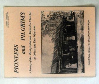
books, Pioneers and Pilgrims, 1986
... photograph of a group of people standing outside a hut with a bark... standing outside a hut with a bark roof. On the right hand side ...Rev Peter Gador-Whyte's first UCA Parish was at Orbost in East Gippsland.This is a local history book useful for research and written by a local.Two copies of a 76 pp book titled Pioneers and Pilgrims a history of the Presbyterian and Methodist Churches in Orbost and East Gippsland. The front cover is buff coloured and has a b/w photograph of a group of people standing outside a hut with a bark roof. On the right hand side is a man on a horse. The book was compiled and edited by the Revd Peter Gador-Whyte.2178.2 - Ruth Leggechurch-history presbyterian-methodist-orbost -
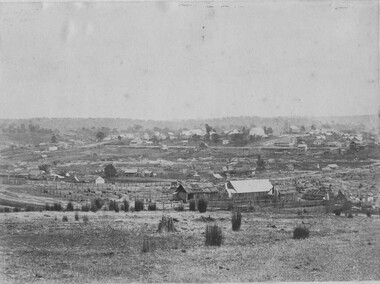 The Beechworth Burke Museum
Photograph, 1865
Taken in Beechworth 1865, this photograph depicts the view of the Spring creek with the Beechworth township in the background. This photograph was taken 13 years after the discovery of Gold at Spring Creek. Within eleven months of the discovery in 1852, over 8000 hopeful prospectors had descended on the region, transforming the seemingly undisturbed land into what a visiting journalist in 1880s referred to as; "A Titan's Field". Huge mounds of earth were churned by hundreds of miners in search for gold, almost every available resource the land had to offer was used for something; even the bark off the gums were stripped to line huts and shafts. By 1857 more than 20,000 people lived in Beechworth, and with this influx the town prospered with the building of numerous churches, banks, schools, shops and hotels along with a prison and hospital.Black and white rectangular photograph. Image is printed on matte photographic paper and is mounted on cardboard.Obverse: NO INSCRIPTION Reverse: BMM6925 / BEECHWORTH FROM SPRING CREEK 1865 beechworth, spring creek, gold rush, titan's field, 1865, prospectors -
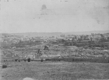 The Beechworth Burke Museum
Photograph, 1865
This image was taken in 1865 overlooking the diggings at Spring Creek, Beechworth. Gold was discovered in this area in 1852 and within eleven months of this discovery, over 8000 hopeful prospectors had descended on the region, transforming the seemingly undisturbed land into what a visiting journalist in 1880s referred to as; "A Titan's Field". Huge mounds of earth were churned by hundreds of miners in search for gold, almost every available resource the land had to offer was used for something; even the bark off the gums were stripped to line huts and shafts. By 1857 more than 20,000 people lived in Beechworth, and with this influx the town prospered with the building of numerous churches, banks, schools, shops and hotels along with a prison and hospital.Black and white rectangular photograph. Image is printed on matte photographic paper and is mounted on cardboard. Obverse: NO INSCRIPTION Reverse: 7771 / BEECHWORTH / FROM SPRING CREEK / 1865 spring creek, diggings, beechworth, 1865 -
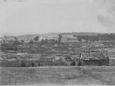 The Beechworth Burke Museum
Photograph, 1865
This image was taken of the diggings at Spring Creek. In February 1852 gold was discovered at Spring Creek, Beechworth. Within eleven months of this discovery, over 8000 hopeful prospectors had descended on the region, transforming the seemingly undisturbed land into what a visiting journalist in 1880s referred to as; "A Titan's Field". Huge mounds of earth were churned by hundreds of miners in search for gold, almost every available resource the land had to offer was used for something; even the bark off the gums were stripped to line huts and shafts. By 1857 more than 20,000 people lived in Beechworth, and with this influx the town prospered with the building of numerous churches, banks, schools, shops and hotels along with a prison and hospital.Black and white rectangular photograph. Image is printed on matte photographic paper and is mounted on cardboard. Obverse: NO INSCRIPTION Reverse: BMM6926 / BEECHWORTH FROM SPRING CREEK 1865 spring creek, beechworth, burke museum, 1865, gold rush -
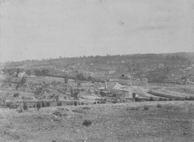 The Beechworth Burke Museum
Photograph, c1865
This was taken in 1865 of Spring Creek, Beechworth. Gold was discovered in this area in 1852 and within eleven months of this discovery, over 8000 hopeful prospectors had descended on the region, transforming the seemingly undisturbed land into what a visiting journalist in 1880s referred to as; "A Titan's Field". Huge mounds of earth were churned by hundreds of miners in search for gold, almost every available resource the land had to offer was used for something; even the bark off the gums were stripped to line huts and shafts. By 1857 more than 20,000 people lived in Beechworth, and with this influx the town prospered with the building of numerous churches, banks, schools, shops and hotels along with a prison and hospital.Black and white rectangular photograph. Image is printed on matte photographic paper and is mounted on cardboard. Obverse: NO INSCRIPTION Revese: 97.22.95 / 7772 / 25/1 / beechworth, burke museum, gold rush, 1865 -
 Ballarat Fire Brigade
Photograph, Unknown
picture gives a good example of streetscape at the time takensmall B&W photograph showing north side of current station. Visable in the picture is part of neighbouring property on northern side of station, station keepers hut and also part of old eastern council officesNileast street, ballarat east, ballarat fire station -
 Halls Gap & Grampians Historical Society
Photograph - B/W, C 1900s
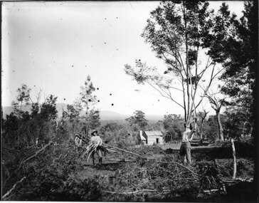
The photo shows wattle-bark stripping, taking place at Roses Gap (western end). The identity of the men is unknown.The photo shows three men in a cleared area of bush, one is standing holding a bundle of wattle bark, another is behind and to the left of him also holding bark and a third is standing to the right and is scrapping bark from a tree above his head with a long stick . There is a hut in the background, the right side of which is just a frame. timber industries, wattlebark stripping, scenery, roses gap -
 Halls Gap & Grampians Historical Society
Photograph - B/W, C 1902
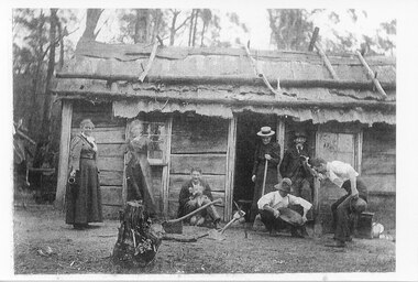
The dwelling is said to be the store at the Stoney Creek diggings, with some members of the Langley family. From left Alice Maria Langley, Lucy, ?, ?, Charles Langley (old man) & three friends.Photo shows three women and three men standing and sitting outside a slab hut. The roof of the hut appears to be constructed of bark, held in place by saplings. One of the men is sitting against the side of the hut and is holding a dog. Another man is crouched over a gold pan while an onlooker appears happy with the contents of the pan."Store at Stoney Creek diggings ?1902. Alice Maria Langley, Lucy ? ? Charles Langley (old man) & three friends." written on back in blue pen.people, langley, mining, gold mining -
 Eltham District Historical Society Inc
Photograph, Slab hut, Warrandyte, Warrandyte Mystery Tour, 29 May 1994, 29/05/1994
[article by Bettina Woodburn in EDHS Newsletter No. 97, July 1994:] THE WARRANDYTE MYSTERY TOUR MAY 29TH 1994 - Members of the Eltham Historical Society met at the Old Post Office, now converted into the Warrandyte Historical Museum, for a picnic lunch on the sunny back verandah overlooking the shimmering Yarra River. Interesting photographs and artefacts filled various rooms outlining the history of this area, and told tales of Aboriginal and more recent neighbours of the Eltham Shire. The weather was calm, cloudy mostly with only occasional sunny patches, but it wasn't cold, although the autumnal leaf colours had changed to wintry brown. "All Aboard" and we set off in the Warrandyte Community Bus (with the School Bus sign displayed at the rear) to learn about local places of "Pride and Joy” from Bruce our guide and Tom the driver. Almost directly opposite we entered Whipstick Gully to explore the first of the district's hidden treasures - the Victory, one of the largest of the six or so major mines, past the old quarry now used for abseiling practice. By torchlight we entered the rocky hillside and saw the seams of quartz the miners had followed in their search for gold. Stamping batteries, and there was one in this gully, converted discarded rock into 'road metal'. Warrandyte is proud to be the first declared Goldfield in 1851, and one of the longest surviving, into the 1920s. A pleasant drive across the Bridge and along Bradley's Lane to Norman's Reserve brought us to see another Tunnel at Pound Bend through which the Yarra was diverted to allow about three miles of river-bed to be used for prospecting for alluvial gold. Still on this side of the river we visited the Old Slab Hut in Castles Road. This remnant of miners' housing is preserved because it had been incorporated into a weatherboard house, and saved from the bulldozers - a last minute reprieve, for preservation, by the National Trust. Devastating bush fires have destroyed other old cottages built of wattle and daub, with bark roofs and stone fire-places. The Cairn commemorating the disclosure of Gold Discovery at Warrandyte on June 30th 1851 beside Anderson's Creek Road was our next point of historical interest. We drove on to South Warrandyte and circled back to above the ford on Anderson's Creek to the entrance of the 4th Hill Mine. Again we crept along with our torches, careful of the low roof-rock, and side shafts. At a junction in a large cavity we were able to stand, look up a long air-vent which some 'cavers' climb down, and marvel at, and experience an aspect of a miner's life. Outside we heard the same bird songs, the trills and bell-pealing, saw the same straggly eucalypts, and a silver leafed wattle in flower, native grasses and ferns, and the neat present day houses, often of Warrandyte stone, perhaps veneered only. The day ended pleasantly, seeing more of the Yarra from Everard Drive, and the water rushing out of the Tunnel at Pound Bend, before returning to afternoon tea or coffee at the Museum. A great day for all concerned - many thanks to the Organisers.Colour photographslab hut, warrandyte, "warrandyte miner's cottage" -
 Eltham District Historical Society Inc
Photograph, Pound Bend tunnel, Warrandyte, Warrandyte Mystery Tour, 29 May 1994, 29/05/1994
[article by Bettina Woodburn in EDHS Newsletter No. 97, July 1994:] THE WARRANDYTE MYSTERY TOUR MAY 29TH 1994 - Members of the Eltham Historical Society met at the Old Post Office, now converted into the Warrandyte Historical Museum, for a picnic lunch on the sunny back verandah overlooking the shimmering Yarra River. Interesting photographs and artefacts filled various rooms outlining the history of this area, and told tales of Aboriginal and more recent neighbours of the Eltham Shire. The weather was calm, cloudy mostly with only occasional sunny patches, but it wasn't cold, although the autumnal leaf colours had changed to wintry brown. "All Aboard" and we set off in the Warrandyte Community Bus (with the School Bus sign displayed at the rear) to learn about local places of "Pride and Joy” from Bruce our guide and Tom the driver. Almost directly opposite we entered Whipstick Gully to explore the first of the district's hidden treasures - the Victory, one of the largest of the six or so major mines, past the old quarry now used for abseiling practice. By torchlight we entered the rocky hillside and saw the seams of quartz the miners had followed in their search for gold. Stamping batteries, and there was one in this gully, converted discarded rock into 'road metal'. Warrandyte is proud to be the first declared Goldfield in 1851, and one of the longest surviving, into the 1920s. A pleasant drive across the Bridge and along Bradley's Lane to Norman's Reserve brought us to see another Tunnel at Pound Bend through which the Yarra was diverted to allow about three miles of river-bed to be used for prospecting for alluvial gold. Still on this side of the river we visited the Old Slab Hut in Castles Road. This remnant of miners' housing is preserved because it had been incorporated into a weatherboard house, and saved from the bulldozers - a last minute reprieve, for preservation, by the National Trust. Devastating bush fires have destroyed other old cottages built of wattle and daub, with bark roofs and stone fire-places. The Cairn commemorating the disclosure of Gold Discovery at Warrandyte on June 30th 1851 beside Anderson's Creek Road was our next point of historical interest. We drove on to South Warrandyte and circled back to above the ford on Anderson's Creek to the entrance of the 4th Hill Mine. Again we crept along with our torches, careful of the low roof-rock, and side shafts. At a junction in a large cavity we were able to stand, look up a long air-vent which some 'cavers' climb down, and marvel at, and experience an aspect of a miner's life. Outside we heard the same bird songs, the trills and bell-pealing, saw the same straggly eucalypts, and a silver leafed wattle in flower, native grasses and ferns, and the neat present day houses, often of Warrandyte stone, perhaps veneered only. The day ended pleasantly, seeing more of the Yarra from Everard Drive, and the water rushing out of the Tunnel at Pound Bend, before returning to afternoon tea or coffee at the Museum. A great day for all concerned - many thanks to the Organisers.Two colour photographswarrandyte, activities, pound bend -
 Eltham District Historical Society Inc
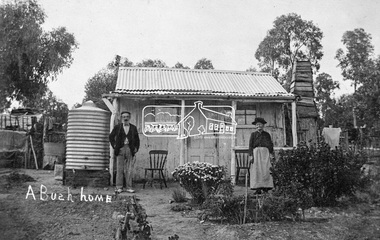
Photograph, Tom Prior, A Bush Home - Research, Vic, c.1895
A slab hut situated in Research, Victoria. An elderly man and woman stand in front of their small bark slab home with bark chimney. It has a tin roof and tin water tank to the side. A small garden is situated at the front. Reproduced on pp 38-39 of 'Pioneers & Painters: One Hundred years of Eltham and it's Shire" (1971) Article in "Australian Family Tree Connections" February 2000 by B. J. Parkinson claims that the people in this photo are "Jonas and Christina Jane (Gregg) PRIOR in front of their home at Ferny Hill, near Eltham, Victoria, 1877". Photocopy of photo also attached to 14 online family trees for the Prior family on Ancestry.com without the words "A Bush Home". References found to Prior in historical newspapers and the property "Ferny Hill". Jonas was a convict from Kent, England. He arrived in Hobart in 1821 aged 19 years. He married Christina Gregg in Hobart about 1834 and had 11 children. They came to Victoria about 1846. He died at Ferny Hill, near Research, Eltham in 1878 aged 74 years and was buried at Melbourne General Cemetery. His occupation was gardener.This photo forms part of a collection of photographs gathered by the Shire of Eltham for their centenary project book,"Pioneers and Painters: 100 years of the Shire of Eltham" by Alan Marshall (1971). The collection of over 500 images is held in partnership between Eltham District Historical Society and Yarra Plenty Regional Library (Eltham Library) and is now formally known as the 'The Shire of Eltham Pioneers Photograph Collection.' It is significant in being the first community sourced collection representing the places and people of the Shire's first one hundred years.Digital image 4 x 5 inch B&W Neg Print 20 x 25 cmshire of eltham pioneers photograph collection, research (vic.), ferny hill, jonas prior, christina prior, hut, prior, convict, pioneers and painters -
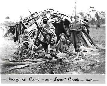 Bendigo Historical Society Inc.
Photograph - HARRY BIGGS COLLECTION: PHOTO OF ABORIGINAL CAMP
... and standing to the right is Batten. Behind them is a hut made of bark.... Behind them is a hut made of bark and sticks. On the bottom ...Black and white photo of a group of Jajoweroung or Loddon Aboriginal people in front of their camp. The group consists of four women sitting behind some wooden branches and four men all in native dress. Two men are standing holding spears and two are sitting. The male standing to the left is Prince Charlie and standing to the right is Batten. Behind them is a hut made of bark and sticks. On the bottom of the photo is printed in black ink 'Aboriginal Camp - on - Boort Creek - 1863 -' Photo is inside envelope 2400 418a. On the back of photo 2400 419a the following is hand written in blue ink. The Jajoweroung or Loddon Tribe of Blacks. Aboriginal Camp - on Boort Creek, 1863. Names of Aborigines - Left to Right. Women sitting in front row - Lizzie, Caroline, Maryanne, Kitty. The two men sitting behind the women - Adam, Nero. The two men standing back row - Prince Charlie, Batten. Photo is in envelope 2400.418aphoto, group, aboriginal camp boort creek, boort creek, prince charles, jajoweroung or loddon tribe -
 Koorie Heritage Trust
Booklet, Barrett, Charles et al, Blackfellows of Australia, 1936
Contents: The Aboriginal Environment - Birds and Reptiles; Whence came the Blackfellow. The Natural Man - Tattooing: ornamental scars. The Tribes of the South - Down the Darling. Tribes of Central and Northern Australia - The Aruntas; Wilderness vanishing; Untamed Tribes. The Tasmanian Race - Doomed people. Tribal Organisation - Public opinion; The Council of Old Men; Tribal Classification; Tribal Naming; Dual Classes; Totemism. Daily life of the Blacks - Making fire; Cooking methods - the native oven; Vegetarian diet; Miscellaneous foods. Weapons and Implements - Classes of Stone; Quarries; Weapons of wood - spears; The Boomerang; Shields; Water vessels and Carriers; Baskets and Dilly-bags.Medicine-men and medicine - Faith cures; Rain-making. Mia-Mias, Whurlies and Gunyahs - Tripod fires; Two-storey huts. The Aboriginal as an Engineer - Weirs and fish traps; Wells and Rockholes. Wild White Men; Dances and Games - Children's toys. Black Police and Tracking - Tribal Mixture; The Blacktrackers; Trained from infancy. Navigation - The Bark Canoe - Calm-weather Craft. Aboriginal Art - Animal Tracks; Old Camp-fires. Blackfellow Music and Bards; Death and Burial - Wailing Women; Relics of Lost Tribes; Decorated skulls; Creation myth pole. Language - Letter-sticks. Myths and Legends; Mission work among the Blacks - Spheres of Service; The Mission Stations.43 p. : ill. ; 28 cm.Contents: The Aboriginal Environment - Birds and Reptiles; Whence came the Blackfellow. The Natural Man - Tattooing: ornamental scars. The Tribes of the South - Down the Darling. Tribes of Central and Northern Australia - The Aruntas; Wilderness vanishing; Untamed Tribes. The Tasmanian Race - Doomed people. Tribal Organisation - Public opinion; The Council of Old Men; Tribal Classification; Tribal Naming; Dual Classes; Totemism. Daily life of the Blacks - Making fire; Cooking methods - the native oven; Vegetarian diet; Miscellaneous foods. Weapons and Implements - Classes of Stone; Quarries; Weapons of wood - spears; The Boomerang; Shields; Water vessels and Carriers; Baskets and Dilly-bags.Medicine-men and medicine - Faith cures; Rain-making. Mia-Mias, Whurlies and Gunyahs - Tripod fires; Two-storey huts. The Aboriginal as an Engineer - Weirs and fish traps; Wells and Rockholes. Wild White Men; Dances and Games - Children's toys. Black Police and Tracking - Tribal Mixture; The Blacktrackers; Trained from infancy. Navigation - The Bark Canoe - Calm-weather Craft. Aboriginal Art - Animal Tracks; Old Camp-fires. Blackfellow Music and Bards; Death and Burial - Wailing Women; Relics of Lost Tribes; Decorated skulls; Creation myth pole. Language - Letter-sticks. Myths and Legends; Mission work among the Blacks - Spheres of Service; The Mission Stations.aboriginals, australian - social life and customs -
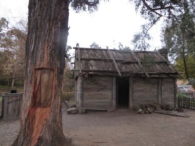 Ballarat Heritage Services
Photograph - Colour, Slab Cottage at Sovereign Hill, 2015, 03/03/2015
Colour photograph of the Slab cottage at Sovereign Hill, Ballarat East. The tree in the foreground features a scar from bark being removed.sovereign hill, main road, scarred tree, slab hut, architecture -
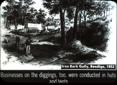 Bendigo Historical Society Inc.
Slide - DIGGERS & MINING. DIGGERS AND MINERS, c1852
Diggers & Mining. Diggers and miners. S.T.G. Iron Bark Gully, Bendigo, 1852. Businesses on the diggings, too, were conducted in huts and tents. Slide depicts the huts and tents at the diggings in which business was conducted. This view you can see there are still quiet a number of trees in the surrounding area, there is also a fence. Miners can be seen walking amongst the tents and huts as well as on the hillside. Markings: 36 994:LIF I. Used as a teaching aid.hanimounteducation, tertiary, goldfields -
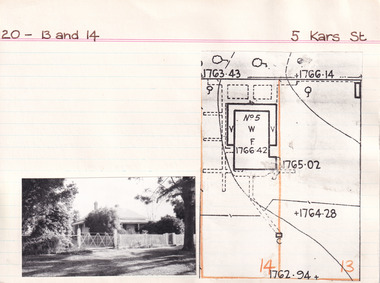 The Beechworth Burke Museum Research Collection
Card (Series) - Index Card, George Tibbits, 5 Kars Street, Beechworth, 1976
George Tibbits, University of Melbourne. Faculty of Architecture, Building and Town & Regional PlanningIndex system that support the research for Beechworth : historical reconstruction / [by] George Tibbits ... [et al]Arranged by street names of BeechworthEach index card includes: street name and number of property, image of property, allotment and section number, property owners and dates of ownership, description of the property according to rate records, property floor plan with dimensions.beechworth, george tibbitsbeechworth, george tibbits -
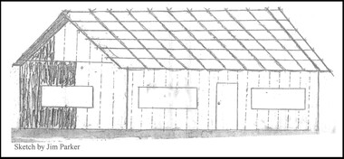 Wodonga & District Historical Society Inc
Drawing - The Green Hills School
Green Hills School was the first school in the Wodonga area. Before the school could open and a teacher commence duties, the Government had to be assured that a minimum of 20 children would be attending. The school was built of round timber, slab walls, bark roof, dirt floor and shuttered windows. The school opened in 1850 and closed in 1870. This sketch, completed by Jim Parker, a Life Member of Wodonga & District Historical Society, was included on a commemorative plaque as part of the Wodonga Heritage Drive established by the Society to recognise the story of key historic locations in the Wodonga area.This drawing is significant because it depicts the first school opened in Wodonga.A sketch of Green Hills School completed by Jim Parker, a life member of Wodonga & District Historical Society. This sketch was completed as part of a project to place commemorative plaques at key locations around Wodonga green hills school, wodonga schools, education wodonga -
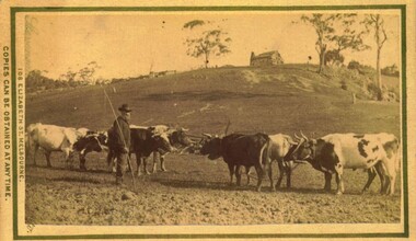 Bacchus Marsh & District Historical Society
Photograph, Bullocks in paddock, near Bacchus Marsh 1883
... and is wearing a very smart hat. On the hilltop stands a large hut... a large hut, possibly with a bark shingle roof. A chimney ...Transportation of goods and material by bullock teams was a common feature of life in nineteenth century Australia. Bullock teams could comprise more than twenty bullocks to haul very large and heavy loads. They were the equivalent of large trucks on the roads of today. Many Australian country towns have very wide main streets to allow for large bullock teams to turn without having to unharness and reharness the animals. The bullock driver in this photo is thought to be of James Densley, aka Charlie (the ) Carter, who lived at Hopetoun, east of the township of Bacchus Marsh. He worked as a carrier with a bullock team in the later years of the nineteenth century. He had a reputation as a sober man who never used bad language. (Williams, W. A History of Bacchus Marsh and its Pioneers. 1836-1936. Reproduced 2015 BMDHS.p. 78.) James Densley died in 1905, supposed to be over the age of ninety.Small sepia unframed photograph on card with gold border framing photograph. Housed in the album, 'Photographs of Bacchus Marsh and District in 1883 by Stevenson and McNicoll'. The image shows a group of seven shorthorn bullocks in a paddock. Their yokes and a chain can be seen. Standing near them is a bearded man holding a bullock team leader's whip. He is dressed neatly and is wearing a very smart hat. On the hilltop stands a large hut, possibly with a bark shingle roof. A chimney is at the end of the dwelling. On the front: Stevenson & McNicoll. Photo. 108 Elizabeth St. Melbourne. COPIES CAN BE OBTAINED AT ANY TIME. On the back: LIGHT & TRUTH inscribed on a banner surmounted by a representation of the rising sun. Copies of this Portrait can be had at any time by sending the Name and Post Office Money Order or Stamps for the amount of order to STEVENSON & McNICOLL LATE BENSON & STEVENSON, Photographers. 108 Elizabeth Street, MELBOURNE. stevenson and mcnicoll 1883 photographs of bacchus marsh and district, bullocks, bullock teams -
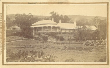 Bacchus Marsh & District Historical Society
Photograph, Glenmore Homestead 1883
... acre Run. It replaced an earlier dwelling which was a slab hut... acre Run. It replaced an earlier dwelling which was a slab hut ...This homestead was built by Charles Griffith on a 55,000 acre Run. It replaced an earlier dwelling which was a slab hut with a bark roof. Charles Griffith, an Irish barrister, with his friend, James Moore, settled on Glenmore Station in the Parwan Valley in 1840. Their partnership lasted until 1848. In 1846, whilst in Ireland, Griffith married Miss Jane Catherine Magee, then returned to Glenmore and later took his nephew, Molesworth Richard Greene, into partnership, which arrangement proved to be long and prosperous. In 1857, they bought runs at Mount Hope and Mount Pyramid, which they kept until the days of free selection. Griffith led an active and successful public life.He was a member of the new Victorian Legislative Council in 1851, and was later an elected representative of the Legislative Assembly 1853-1859. He occupied many important public positions, including that of magistrate for Bacchus Marsh. Griffith was a devout Anglican and hosted Bishop Charles Perry at his station near Bacchus Marsh in 1849. He died in 1863 at his home in South Yarra.Small sepia unframed photograph on card with gold border framing photograph. Housed in the album, 'Photographs of Bacchus Marsh and District in 1883 by Stevenson and McNicoll'. The photograph shows a view of an extensive single-storey homestead consisting of three adjoining buildings, with a further building on the left of the main property. The series of three buildings is built in an elevated position, with pathways leading through a garden. At the front there is a vegetable garden which seems to be still in a state of development. The main house, possibly of brick, is set at an angle to the other two in this complex. It has a hip roof with a concave verandah on two sides with arched barge boards and simple unadorned pillars. There appears to be a hammock slung between two pillars. Two chimneys can be seen on this dwelling.The adjoining building is of a simpler design, with a lower roof line and a verandah running along the front. Two chimneys can be seen, one emitting smoke. This middle building may be a kitchen and rooms for day-to-day use. The third building is also of a simpler design, with a gable above a verandah. The purpose of this building is less clear. The different styles of construction suggest that these buildings were built separately at different times for different purposes. To the left of the main group of buildings is another cottage, smaller and of a simpler design. A fence runs along the front, clearly separating this building from the others, suggesting it may have been the dwelling of an overseer.On the front: Stevenson & McNicoll. Photo. 108 Elizabeth St. Melbourne. COPIES CAN BE OBTAINED AT ANY TIME. On the back: LIGHT & TRUTH inscribed on a banner surmounted by a representation of the rising sun. Copies of this Portrait can be had at any time by sending the Name and Post Office Money Order or Stamps for the amount of order to STEVENSON & McNICOLL LATE BENSON & STEVENSON, Photographers. 108 Elizabeth Street, MELBOURNE. stevenson and mcnicoll 1883 photographs of bacchus marsh and district, farms bacchus marsh, charles james griffith 1808-1863, glenmore station -
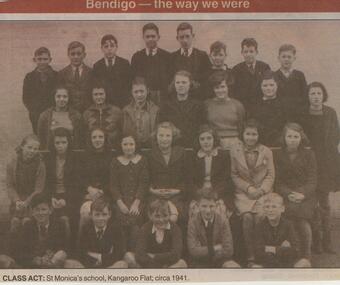 Bendigo Historical Society Inc.
Newspaper - JENNY FOLEY COLLECTION:CLASS ACT
... Initially a slab hut with a bark roof was built in 1860...Initially a slab hut with a bark roof was built in 1860 ...Initially a slab hut with a bark roof was built in 1860 by Dr Backhaus. St Monica's church was built in 1864 and was initially used as a church school. The bricks of the church were made from clay in the church grounds. In the 1920's the school was run by the Sisters of Mercy.Bendigo Advertiser ''The way we were'' from Wednesday, April 17, 2002. Class act: St Monica's school, Kangaroo Flat, circa 1941. The clip is in a folder.newspaper, bendigo advertiser, the way we were