Showing 74 items
matching basin study
-
 Eltham District Historical Society Inc
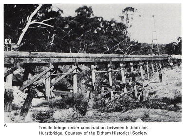
Work on paper (Sub-Item) - Photograph, Trestle bridge under construction between Eltham and Hurstbridge
... Image printed on A4 page from 04997 Diamond Creek Basin... hurstbridge Image printed on A4 page from 04997 Diamond Creek Basin ...Black and white photograph of the bridge under construction. The line opened at Hurstbridge in 1912.bridge, hurstbridge -
 Eltham District Historical Society Inc
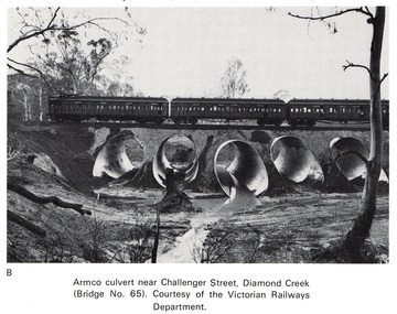
Work on paper (Sub-Item) - Photograph, Armco culvert near Challenger Street, Diamond Creek
... Image printed on A4 page from 04997 Diamond Creek Basin... 04997 Diamond Creek Basin Study, 1980 Armco culvert near ...Black and white photograph. A passenger train crosses Victorian Railways Bridge No 65 near Challenger Street, Diamond Creek. A series of steel culverts or tunnels carrying a stream have been constructed beneath the railway bridge.bridge, culvert, train, challenger street -
 Eltham District Historical Society Inc
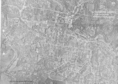
Work on paper (Sub-Item) - Aerial Photograph, Diamond Creek from Yarra River to Wattletree Road, Eltham
... Basin Study, 1980... Image printed on foldout A3 page from 04997 Diamond Creek Basin ...Black and white aerial photograph witrh key features around the central place of Eltham township marked inluding Yarra River, Main Road, Bridge Street and Ryans Road, Eltham North land development, real estate, aerial view, eltham, eltham north -
 Eltham District Historical Society Inc
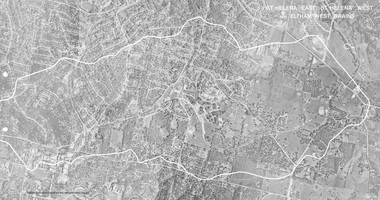
Work on paper (Sub-Item) - Photograph, St Helena East, St Helena West and Eltham West drains, ca 1980
... Basin Study, 1980... Basin Study, 1980 St Helena East, St Helena West and Eltham West ...black and white aerial photograph with boundary and drains marked over three page fold out eltham, st helena, drains, aerial view -
 Eltham District Historical Society Inc
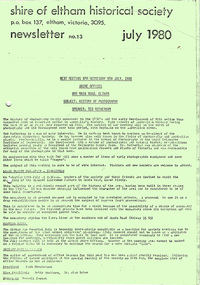
Newsletter, Newsletter, No. 13, July 1980
... • Diamond Creek Basin Study • Donations to the Society • Committee... • Diamond Creek Basin Study • Donations to the Society • Committee ...Contents: • Local Plenty Monastery – inspection • Meeting venue • Society Office Bearers • Recent activities • Subscriptions • Information required • Library reference sources • Diamond Creek Basin Study • Donations to the Society • Committee meeting The Shire of Eltham Historical Society was formed in October 1967. The first newsletter of the Society was issued May 1978 and has been published continuously ever since on a bi-monthly basis. With the cessation of the Shire of Eltham in late 1994, the Society's name was revised to Eltham District Historical Society and this name first appeared with issue No. 103, July 1995. The collection of the Society's newsletters provides a valuable resource on the history of the Society's activities, office bearers and committee members, guest speakers and subjects of historical interest pertinent to the former Shire of Eltham and the Eltham District.A4 photocopied newsletter distributed to membersnewsletter, eltham district historical society, shire of eltham historical society -
 Eltham District Historical Society Inc
Photograph, 1934 Floods at Eltham
... Published in the Diamond Creek Basin Study, 1980... melbourne Published in the Diamond Creek Basin Study, 1980 ...Published in the Diamond Creek Basin Study, 1980 and identified at Diamond Creek, locality not identified, 1934. The location is actually looking south across the Diamond Creek towards Falkiner Street, beside the Main Road bridge at Eltham South from what is now part of Wingrove Park opposite Antoinette Boulevard. The bridge railing is just visible to the left of image. The large leaning Manna Gum beside the bridge still stands in 2021 alongside the Diamond Creek trail. In 1934 extensive flooding of the Yarra River and Diamond Creek set new records for flood plain level (Eltham Chronology, EDHS)Black and white photographCopied by Hugh Fisher, Photographer, 6 York Street Eltham A1678B Floods- Eltham - 1934floods, yarra river, eltham, flooding, diamond creek, flood -
 Bendigo Historical Society Inc.
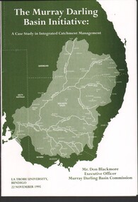
Booklet - 1995 Sir John Quick Lecture - "The Murray Darling Basin Initiative", Michele Matthews Collection, 1995
... Sir John Quick Bendigo Lecture - "The Murray Darling Basin... Lecture - "The Murray Darling Basin Imitative: A Case Study ...La Trobe University, Sir John Quick annual lectureSir John Quick Bendigo Lecture - "The Murray Darling Basin Imitative: A Case Study in Integrated Catchment Management". Presented by Mr. Don Blackmore, Executive Officer Murray Darling Basin Catchment, on 22 November 1995 at 6:45 PM; in the McKay Lecture Theatre, La Trobe University. B&W printed booklet with green light card cover. Includes invitation to the lecture.sir john quick annual lecture, mr. don blackmore -
 The Beechworth Burke Museum
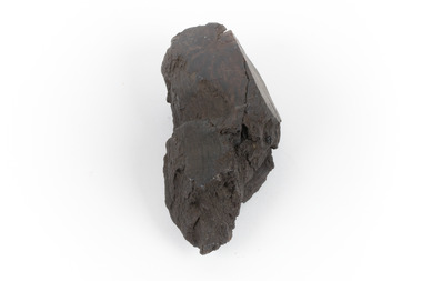
Geological specimen - Brown coal
This particular specimen was recovered from the Lal Lal Coal and Iron Mine in Victoria, 19km from Ballarat. Brown Coal was discovered here in 1857, just alongside the Geelong to Ballarat Railway line. This discovery of lignite (brown coal) was the first in Victoria, which would bring important benefits to the region and state, both of which had previously been reliant on coal imports. In the 1860s, iron ore was found just 5km from Lal Lal, and the area was converted into an Iron Ore Mine. The Lal Lal Iron Mining Company took over operations in 1874, who then peaked iron production in 1884. This mine continued operations until June 1884, when the blast furnace was extinguished and never recommenced. The blast furnace at Lal Lal is considered one of the most important and highly significant sites ion early industrial history in Australia, as it is the only remaining best furnace from the nineteenth century in the Southern Hemisphere. The furnace ruins are 17 metres high, and are clearly visible today on Iron Mine Road, Lal Lal, near the Bungal Dam. This specimen of Lignite (brown coal) is significant, as it was mined from the area where brown coal was first discovered in Victoria, leading to an important and controversial future of the mining and use of brown coal in this State. The Victorian Heritage Database has listed the Lal Lal Coal Mine with local significance, with their Statement of Significance stating: "The Lal Lal coal mine is historically significant as the site of the first discovery of lignite (brown coal) in Victoria, and one that promised important benefits to regional and state industries that were reliant on coal imports at the time. The significance of the stie is reduced by the poor state of preservation of the coal mining and processing fabric". This specimen is part of a larger collection of geological and mineral specimens collected from around Australia (and some parts of the world) and donated to the Burke Museum between 1868-1880. A large percentage of these specimens were collected in Victoria as part of the Geological Survey of Victoria that begun in 1852 (in response to the Gold Rush) to study and map the geology of Victoria. Collecting geological specimens was an important part of mapping and understanding the scientific makeup of the earth. Many of these specimens were sent to research and collecting organisations across Australia, including the Burke Museum, to educate and encourage further study.A hand-sized light-weight, soft and combustable sedimentary rock specimen, that is dark brown in colour. The specimen has jagged edges, as though parts of the rock have crumbled away. Brown coal, or Lignite, is formed naturally from compressed peat, and is typically found in natural basins. The stages to the formation of coal ('coalification') begin with plant material and wood, which will decay if it is not subjected to deep burial or heating, and turn into Peat. Peat, when sufficiently compressed naturally, will turn into Brown Coal (Lignite), and finally into Black Coal (sub-bituminous, bituminous and anthracite). Each successive stage has a higher energy content and lower water content. It is brownish-black in colour. Brown Coal has a high moisture content, between 50 and 75 percent, and a low carbon content. Some Brown Coals may be stratified, with layers of plant matter, which means little coalification has occurred beyond the peat natural processing stage. When Brown Coal is submerged in dilute nitric acid or boiling potassium hydroxide solution, it reacts to produce a reddish solution, of which higher-ranked coals do not. When brown coal is pulverised and burned in boilers, the steam is used to drive turbines, which generates electricity. It is the lowest rank of coal, as when burned, it creates a relatively low heat content, which in turn does not create a great output of steam. burke museum, beechworth, indigo shire, beechworth museum, geological, geological specimen, mineralogy, brown coal, brown coal specimen, lignite, lal lal, lal lal coal mine, lal lal iron mine, ballarat, blast furnace -
 The Beechworth Burke Museum
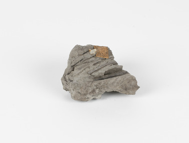
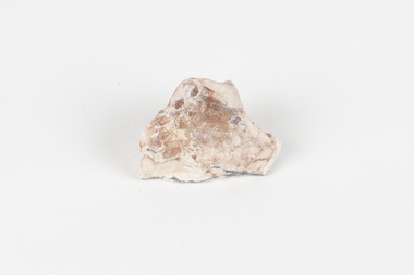
Geological specimen - Fossiliferous Mudstone, Unknown
This specimen was found in Cape Patterson, Vic. Cape Paterson is a cape and seaside village located near the town of Wonthaggi, 132 kilometres southeast of Melbourne, in the Bass Coast Shire of Gippsland, Victoria, Australia. These dark, fossiliferous Mudstones were deposited in slow-moving water associated with sedimentary basins & continental shelves. They are rich in carbon which makes them almost black. This is typical of an anoxic, reducing environment such as deep water or stagnant conditions where carbon-rich material would remain unoxidised during subsequent deposition & diagenesis. it has an imprint of a leaf in the rock itself, displaying the fossil of the plant. This specimen is unique due to the leaf impression within the stone itself. Imprint fossils are formed from an organism moving in some way, leaving behind a trace or track. These tracks are preserved when the clay/silt dries slowly and is covered by other sediment. Plants can also leave imprint fossils when they are covered by sediment. The leaf tissue degrades, leaving an imprint of where the leaf once was. This specimen is part of a larger collection of geological and mineral specimens collected from around Australia (and some parts of the world) and donated to the Burke Museum between 1868-1880. A large percentage of these specimens were collected in Victoria as part of the Geological Survey of Victoria that begun in 1852 (in response to the Gold Rush) to study and map the geology of Victoria. Collecting geological specimens was an important part of mapping and understanding the scientific makeup of the earth. Many of these specimens were sent to research and collecting organisations across Australia, including the Burke Museum, to educate and encourage further study.These dark, fossiliferous Mudstones were deposited in slow moving water associated with sedimentary basins & continental shelves. They are rich in carbon which makes them almost black. This is typical of an anoxic, reducing environment such as deep water or stagnant conditions where carbon rich material would remain unoxidised during subsequent deposition & diagenesis. FOSSILIFEROUS MUDSTONE / Locality: Cape Patterson, Victoria | Descriptive catalogue / Pg 27 No 95 / "Grey Clay, / Cape Paterson with leaf impressions' / 15/4/21 C. William /mudstone, cape patterson, leaf imprint, fossilised leaf, fossiliferous mudstone -
 The Beechworth Burke Museum
Geological specimen - Opal Bearing Stone, Unknown
There are 17 opal fields in Australia. This opal bearing stone was found in Lightning Ridge, NSW over what is known as the Great Australian Basin. This basin was formed and covers an area of 1.7 million square kilometers in eastern Australia in the Cretaceous period. This basin used to contain an inland sea, which provided an environment where silcrete eventually formed when water levels changed. This eventually seeped into other structures, and eventually hardened and formed opal. Lightning Ridge has a population of around 2000 people, with about 80 000 visitors every year. It is a historic mining town, and is known for its deposits of a rare black opal. Mining started in the area in the late 1800s, early 1900s when the black opal was discovered. This opal-bearing stone is of social and historical significance. It is from Lightning Ridge, which is well-known for being a large producer of opal stones, most famously black opal. The history of the period dates back to 140 million years, with the discovery of black opal in the early 1900s causing interest in the area. This specimen is part of a larger collection of geological and mineral specimens collected from around Australia (and some parts of the world) and donated to the Burke Museum between 1868-1880. A large percentage of these specimens were collected in Victoria as part of the Geological Survey of Victoria that begun in 1852 (in response to the Gold Rush) to study and map the geology of Victoria. Collecting geological specimens was an important part of mapping and understanding the scientific makeup of the earth. Many of these specimens were sent to research and collecting organisations across Australia, including the Burke Museum, to educate and encourage further study.***A palm-sized solid mineral specimen in shades of beige and light orange*** silica based? burke museum, beechworth, geological, geological specimen, opal, opal fields, australia, lightning ridge, new south wales, great australian basin, cretaceous, silcrete, black opal, mining -
 Flagstaff Hill Maritime Museum and Village
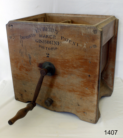
Domestic object - Butter Churn, Cherry and Sons, 1890-1920
The subject item is a good example of a large, hand-operated Bentwood box butter churn used to make up to 14 pounds of butter. It was made in Gisborne, Victoria, by the famous manufacturer, E. Cherry, and is known as an Improved Patent No.2 model probably dating from the late 1800s. The Cherry works specialised in making all types of butter churns and equipment for both domestic use on farms and small butter factories during the late nineteenth and early to mid. twentieth centuries. Milk was "separated" to retrieve the cream which was then beaten to make butter. E Cherry began making various models of Cherry butter churns in 1858, Edward Cherry migrated from Herefordshire England to Australia in 1855 with his wife Ann Appleby, nee Davis, and established a joinery workshop at Gisborne, Victoria. He began by making butter churns in his spare time and his product soon became popular allowing him to establish a viable business. A factory was established in 1875 and he started to make churns of all sizes including up to industrial scale. He exported his products to many countries around the world, Edward Cherry died in 1909 and the business was then run by his son George until he died in 1917. E Cherry's other son Thomas (1861-1945) was also involved in the firm maintaining an interest for several years. He had been born in Gisborne and became a senior house medical surgeon at the Melbourne Hospital in 1890. He continued his studies at Kings College London, eventually becoming a renowned bacteriologist and agricultural scientist. A significant item giving an snapshot into how early industrial manufacturing became established in Australia in the production of domestic and industrial dairy equipment.Butter churn wooden manually operated made by Cherry and Sons with rotating lever curved plywood basin and parallel cross beamed horizontally spoken churning apparatus inside with wooden plug at lower side of churn. Label in block transfer "E CHERRY / MAKER / GISBORN / VICTORIA / 2" "IMPROVED PATENT"warrnambool, shipwrecked-coast, flagstaff-hill, flagstaff-hill-maritime-museum, maritime-museum, shipwreck-coast, flagstaff-hill-maritime-village, butter churn, wooden butter churn, e cherry & sons, dairy equipment, gisborne, food preparation -
 Tatura Irrigation & Wartime Camps Museum
Folder, Rural Water Corporation
Contents include material on dethridge water meter, Murray-Darling basin, Lake Nillahcootie, Western port rivers. Management study of State of the rivers, Rural Water Commission school project package. 3 papers on Lake DartmouthFolder, marbled black and white cover. metal lever insiderural water corporation, tatura, water, documents, reports -
 Wodonga & District Historical Society Inc
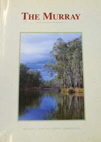
Book - THE MURRAY, Norman Mackay and David Eastburn, 1990
A study of the Murray River system, commissioned by the Murray Darling Basin Commission and published in 1990. This book provided a starting point for the understanding needed to make sustainable development og the Murray-Darling system an achievable goal. It provides a basis for action to halt futher degradation of the River and to rehabilitate its damaged environment. The picture that emerges from this volume is of a river in decline but not yet beyond saving. It covers topics such as groundwater and salinity, the associated fauna and flora, the surrounding environment, and the human impact. Illustrated with maps, diagrams and colour photographs. Includes a glossary and an index.non-fictionA study of the Murray River system, commissioned by the Murray Darling Basin Commission and published in 1990. This book provided a starting point for the understanding needed to make sustainable development og the Murray-Darling system an achievable goal. It provides a basis for action to halt futher degradation of the River and to rehabilitate its damaged environment. The picture that emerges from this volume is of a river in decline but not yet beyond saving. It covers topics such as groundwater and salinity, the associated fauna and flora, the surrounding environment, and the human impact. Illustrated with maps, diagrams and colour photographs. Includes a glossary and an index.upper murray region, murray river ecology, stream ecology murray river -
 Wodonga & District Historical Society Inc
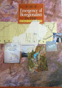
Book - The Emergence of Bioregionalism in the Murray-Darling Basin, Joseph Michael Powell, 1993
A study of environmental policy and conservation issues in the Murray Darling Basin of Australianon-fictionA study of environmental policy and conservation issues in the Murray Darling Basin of Australiamurray-darling basin, environmental policy, murray-darling basin -- history., conservation of natural resources