Showing 265 items matching "beacons"
-
 Port Melbourne Historical & Preservation Society
Photograph - Queen Elizabeth II, Station Pier, Port Melbourne, Ted Kobelt, 7 Feb 1999
One of ten colour photographs taken at Station Pier: Queen Elizabeth II and outer beacon, 11th February 1999details pencilled on backtransport - shipping, piers and wharves - station pier, rms queen elizabeth 2, qe2 -
 Port Melbourne Historical & Preservation Society
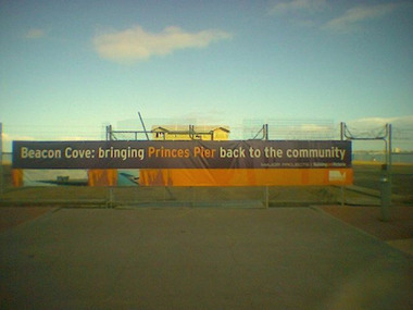
Photograph - Princes Pier, Port Melbourne, during Beacon Cove development, 2006
the sign was erected by the Victorian Government shortly after they announced that Princes Pier was not going to be developed but would be truncated and restored for use by walkers, small boats, fishers etcColour photo of Princes Pier with cyclone fence and sign "Beacon Cove : bringing Princes Pier back to the community". 2006piers and wharves - princes pier, beacon cove -
Port Melbourne Historical & Preservation Society
Plan - Proposed Beacon Cove Development plan by Sandridge City Development Company Pty Ltd, 17 July 1989
A photocopy of a detailed of areas 14 & 15 of the plan for Beacon Cove from the Sandridge City Development Company Pty Ltd.sandridge city development company pty ltd, local government - city of port melbourne, beacon cove -
 Port Melbourne Historical & Preservation Society
Postcard - Port Melbourne series, Alison Kelly, 1991
... Beacons ...Both photographers were concerned about heritage places soon to be demolished or altered. Printing of the postcards was paid for by Port Melbourne Council.From a set of nine colour postcards featuring heritage places on the Port waterfront. Images by Alison KELLY (nos 4-9) and James LAURITZ (nos 1-3) 1991 1. Aerial photo of Bay St. 2. Starch factory shell. 3. Sunset over Station Pier. 4. Beacon (outer) 5. Gatehouse Station Pier. 6. Seamen's Mission building. 7. Abel Tasman ferry. 8. Old Eastern kiosk. 9. Centenary Bridge stairway.piers and wharves - station pier, piers and wharves - princes pier, piers and wharves - lagoon pier, beacons, built environment, transport - ferries, missions to seamen, james lauritz, alison kelly, abel tasman -
 Flagstaff Hill Maritime Museum and Village
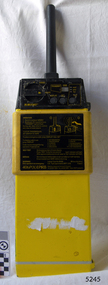
Equipment - EPIRB Transmitter
This distress EPIRB unit (Emergency Position Indication Radio Beacon) was found on the beach at Levy's Point, Warrnambool, in December 2000 by a Warrnambool resident. Local police were alerted at the time. This distress signal unit is a world-wide COSPAS/SARSAT, satellite assisted, SAR (Search and Rescue) system for location of distress transmissions emitted by an EPIRB. Offshore cruising vessels must have such a unit as part of its essential safety equipment. This model EPIRB relies on four satellites with orbit times of approximately 100 minutes. Earlier units relied solely on aircraft flying overhead to detect and forward on the EPIRB’s location to Search And Rescue authorities, whereas this new system utilises satellites. An employee from the Lokata firm provided additional information about the Lokata EPIRB units. They had a machined aluminium case with labels that were also made on site. The units could be activated manually or automatically released when a magnetic switch in the case casing was activated. This later model, circa 1983, would have been mounted externally on a vessel's bulkhead in a spring-loaded, stainless-steel protective 'skeleton' mounting, The unit released when the water pressure sensor detected a set time it was under the water, in a similar way that life crafts were released. Each unit was registered to a particular vessel - the vessel's details on this unit are indecipherable. The Lokata Company was established in 1970, designing and manufacturing marine products including communications. The company no longer makes products with the “Lokata” brand. In 2001 Sartech Engineering Ltd. took over the support for the Lokata EPIRB beacons. This emergency location device is a late 20th century invention to help save lives at sea. It adds to the history of maritime life, its risks, the lives lost as sea, and the many inventions aimed as rescuing and saving lives. The local area is notorious for the number of lives lost through shipwreck. It also carries stories of heroic efforts to save lives, and other inventions to help reduce the chance of accidents at sea.EPIRB unit; “Emergency Position Indication Radio Beacon”. A distress communication unit for sending a distress location transmission in an emergency at sea. The EPIRB is a yellow, rectangular box with dials, buttons, indicator lights and instruction. An antenna protrudes from the top of the unit. The EPIRB unit sends a 406P (X) EPIRB, with 406M-Hz frequency, 48-hour duration signal. The maker was LOKATA Ltd in England. Remnants of a white label remain on the side. Circa 1980s."NAME OF VESSEL 'SERVICE IF SELF TEST FAILS' " “LO-KATA” moulded into the body. "406P (X) EPIRB" “Model 406” "Lokata Type No 92408" "UK Type approved to MPT 1278" "Class 2" "Made by Lokata Ltd, Falmouth Cornwall England TR10 8AE"" "LOKATE LTD. New North Road Hainault, Ilford Essex IG6 2UR" "ARMED / SAFE / TRANSMIT / CODE / DISPLAY / SET / wait / pass / fail / TEST" "IDENTIFIER / 1349:24034234N" [some characters may be different] "COUNTRY / DENMARK" "VESSEL IDENTITY / 124 [the rest is indecipherable]flagstaff hill, warrnambool, shipwrecked-coast, flagstaff-hill, flagstaff-hill-maritime-museum, maritime-museum, shipwreck-coast, flagstaff-hill-maritime-village, emergency position indicating radio beacon, epirb, lokata ltd, marine safety equipment, satellite transmitting beacon, safety equipment, distress signal, life saving, safety at sea, shipwreck location, lo-kata, falmouth, emergency, beacon, radio signal, communication, marine equipment -
Port Melbourne Historical & Preservation Society
Photograph - Various port scenes, 1980s - 1990s
Looking towards Princes Pier during bicentenary celebrations. Appears to be a ferris wheel on foreshore. Leading light (beacon) is centre of image.piers and wharves - webb dock, piers and wharves - station pier -
Port Melbourne Historical & Preservation Society
Plan - Proposed Beacon Cove Development plan by Sandridge City Development Company Pty Ltd, 17 July 1989
A photocopy of a detailed of areas 1, 7 & 8 of the plan for Beacon Cove from the Sandridge City Development Company Pty Ltd.sandridge city development company pty ltd, local government - city of port melbourne, beacon cove -
 Phillip Island and District Historical Society Inc.
Photograph, Early 20th Century
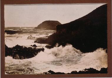
One of a collection of 13 photographs donated by Ralph Correy.Black & White photograph of breaking waves over rocks looking towards The Nobbies. Two little specks on top of The Nobbies are the Lighthouse and Beacon.the nobbies phillip island, breaking waves, south coast phillip island, ralph correy -
Port Melbourne Historical & Preservation Society
Photograph - Construction of Beacon Cove, Port Melbourne, Ron Laing, 1991 - 1992
Part of Ron Laing's collection of photographs recording Port Melbourne over a thirteen year period. Donated to the PMH&PS by the photographer.A set of 73 colour photographs covering the construction of Beacon Cove (first stage of uncompleted Sandridge City Development Corporation's bayside development)built environment - domestic, ron laing, sandridge city development company pty ltd, scdc -
Port Melbourne Historical & Preservation Society
Archive - CD-ROM, Sandridge City Development Corporation development
A CD index of everything to do with the Sandridge City Development Corporation (SCDC - Beacon Cove -Mirvac) as noted in other 2939 catalogue numbers .town planning - proposals shelved - bayside, built environment, local government - city of port melbourne, public action campaigns, bayside development action group, bayside working group, scdc, beacon cove, mirvac, beris campbell, sandridge city development company pty ltd -
Port Melbourne Historical & Preservation Society
Negative - Negative, Barak Road Development Area Services plan, City of Port Melbourne, City of Port Melbourne, Barak Road Development Area Services, 27 Sep 1971
4" x 5" negative of City of Port Melbourne plan, Sept 1971, of services required for development between Barak and Beacon Roadstransport - railways, town planning, local government - city of port melbourne -
 Port Melbourne Historical & Preservation Society
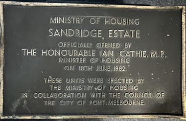
Plaque - Opening of Ministry of Housing Sandridge Estate , Port Melbourne, 18 June 1982
The public housing units were demolished in 2023.Oblong brass plaque commemorating the opening of the Sandridge Estate by The Honourable Ian Cathie ,M.P. The Sandridge Estate was known locally as Barak Beacon.The units were erected by Ministry of Housing in collaboration with the Council of the City of Port Melbourne.built environment - public housing, sandridge estae, barak beacon -
Port Melbourne Historical & Preservation Society
Plan - Proposed Beacon Cove Development plan by Sandridge City Development Company Pty Ltd, 17 July 1989
A photocopy of a detailed of areas 3,4,11,12, 5c, 5b & 5c of the plan for Beacon Cove from the Sandridge City Development Company Pty Ltd.sandridge city development company pty ltd, local government - city of port melbourne, beacon cove -
Port Melbourne Historical & Preservation Society
Document - Invitation, tour of Bayside buildings to be demolished, Alison Kelly, Dec 1989
Sent to donor Pat Grainger, participant in the tour. Stood on her mantlepiece for 15 years before being donated to societyHandpainted seasonal greeting card, invitation to a 1989 tour of Bayside buildings to be demolished for development, conducted by Alison Kelly (Refer 1074.01 and .02): Alison's watercolour of outer beacon in blue and brown pasted on front. Details of beacon, and invitation to the walk typed on separate papers and pasted inside, and handwritten greeting from the three caretakers of the Missions to Seamen building.In black ink inside: 'Dear Pat, happy Christmas and New Year. Love, Allie, Brian, Michael'demolitions, alison kelly -
 Phillip Island and District Historical Society Inc.
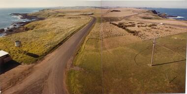
Photograph, John Cook, 1978-79
Photograph a part of the John Cook AlbumView looking east from the new Beacon Tower (1979) back along the Island. Cat Bay in the distance on the left and Bass Straight on the right.the nobbies phillip island, cat bay phillip island, john cook, coloured photograph -
Port Melbourne Historical & Preservation Society
Photograph - Construction of apartment towers at Beacon Cove, Port Melbourne, Ron Laing, 1990s
Part of Ron LAING's collection of photographs recording Port Melbourne over a thirteen year period. Donated to the PMH&PS by the photographer.A set of 81 colour photographs covering the construction of the first to the fourth apartment towers of Mirvac's Beacon Cove development, between Station and Princes Piersbuilt environment - domestic, ron laing, mirvac -
Port Melbourne Historical & Preservation Society
Photograph - Beacon Cover project from Graham Street overpass, Port Melbourne, Alison Kelly, 1991
Two colour photographs taken from the Graham Street overpass looking southwest towards the beach, prior to the building of the Beacon Cove project c1991demolitions, built environment -
Port Melbourne Historical & Preservation Society
Plan - Proposed Beacon Cove Development plan by Sandridge City Development Company Pty Ltd, 17 July 1989
A photocopy of a detailed of areas 2, 6, 9, 10, & 13 of the plan for Beacon Cove from the Sandridge City Development Company Pty Ltd.sandridge city development company pty ltd, local government - city of port melbourne, beacon cove -
Port Melbourne Historical & Preservation Society
Audio - PMHPS Meeting, Lighthouses, John Ibbotson, 27 Mar 2006
... Beacons ...Recording of PMHPS Meeting on 27.03.2006. Recording done at Port Melbourne Bowling Club. Speaker was John Ibbotson regarding lighthouses around the Australian Coast. Recording duration 1:11:11beacons, john ibbotson -
Port Melbourne Historical & Preservation Society
Photograph - Aerial view Webb Dock and Beacon Cove site, Port Melbourne, 6 Sep 1997
(.01) Aerial photographic view of Webb Dock - September 1997 (.02) Aerial view of cleared site for future Beacon Cove project - September 1997piers and wharves - webb dock, built environment, beacon cove -
 Young Christian Workers (YCW Australia) Archive and Research Centre
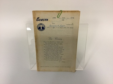
Bulletin, National Catholic Girls' Movement, Beacon 1956 Apr-Jun, 1956
Part of the Marg Armstrong (nee Moore) collection.This bulletin provides a guide to group leaders for conducting meetings. It belonged to Margaret Moore, who was an influential leader within YCW.Booklet, 44 ppBeacon April - May = June 1956 / Price 3/- / 'Margaret Moore' / Bulletin for Leaders of the National Catholic Girls' Movement / The Rosary margaret armstrong (nee moore), beacon, national catholic girls' movement, bulletin, ycw, young christian workers -
Port Melbourne Historical & Preservation Society
Document, Port Melbourne Management Framework - Managing Change Draft Report May 2003, 2003
Planning report produced by City of Port Philipp which addresses planning issues affecting Port Melbourne area, from Bay street to Beacon Road. Used as lobbying tool in relation to Beacon Cove Stage 8. Historical section inaccurate and not to be relied upon.Port Melbourne Management Framework - Managing Change Draft Report May 2003. Acetate cover, wire binding, 117 pagespiers and wharves - town pier, town planning, built environment, piers and wharves - station pier, piers and wharves - princes pier, beacon cove -
Port Melbourne Historical & Preservation Society
Drawing - Artist's impression of proposed Beacon Cove development, 1994
A photocopy of an artist's impression of the Hobson's Bay Elevation for the Beacon Cove Bayside development. The drawing was prepared by Mirvac for the Office of Major Projects by the firm of Henry Pollock and Associates.port melbourne foreshore, built environment - domestic, beacon cove, bayside development -
Port Melbourne Historical & Preservation Society
Drawing - Artist's impression of proposed Beacon Cove development, 1994
A photocopy of an artist's impression of the Hobson's Bay Elevation for the Beacon Cove Bayside development. The drawing was prepared by Mirvac for the Office of Major Projects by the firm of Henry Pollock and Associates.port melbourne foreshore, beacon cove, bayside development -
Port Melbourne Historical & Preservation Society
Drawing - Artist's impression of proposed Beach Street development, 1994
A photocopy of an artist's impression of Beach Street as proposed for the Beacon Cove Bayside development. The drawing was prepared by Mirvac for the Office of Major Projects by the firm of Henry Pollock and Associates.port melbourne foreshore, built environment - domestic, beacon cove, beach street, bayside development -
Port Melbourne Historical & Preservation Society
Drawing - Artist's impression of proposed Beacon Cove Harbour development, 1994
A photocopy of an artist's impression of the proposed Harbour area of the Beacon Cove Bayside development. The drawing was prepared by Mirvac for the Office of Major Projects by the firm of Henry Pollock and Associates.port melbourne foreshore, built environment - domestic, beacon cove, bayside development -
Port Melbourne Historical & Preservation Society
Drawing - Artist's impression of proposed Swallow Street development, 1994
A photocopy of an artist's impression of Swallow Street as proposed for the Beacon Cove Bayside development. The drawing was prepared by Mirvac for the Office of Major Projects by the firm of Henry Pollock and Associates.port melbourne foreshore, built environment - domestic, beacon cove, bayside development -
Port Melbourne Historical & Preservation Society
Drawing - Artist's impression of proposed Beacon Cove Civic Square development, 1994
A photocopy of an artist's impression of the proposed Civic Square for the Beacon Cove Bayside development. The drawing was prepared by Mirvac for the Office of Major Projects by the firm of Henry Pollock and Associates.port melbourne foreshore, built environment - domestic, beacon cove, beacon cove civic square, bayside development -
Port Melbourne Historical & Preservation Society
Drawing - Artist's impression of proposed Beacon Cove development, 1994
A photocopy of an artist's impression of the proposed Civic Square for the Beacon Cove Bayside development. The drawing was prepared by Mirvac for the Office of Major Projects by the firm of Henry Pollock and Associates.port melbourne foreshore, built environment - domestic, beacon cove, bayside development -
 Phillip Island and District Historical Society Inc.
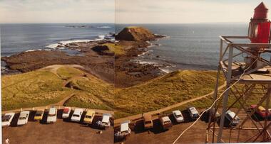
Photograph, John Cook, 1978-79
The Nobbies & Seal Rocks is the extreme western tip of Phillip Island.Two joined coloured photographs showing a view of The Nobbies & Seal Rocks from the newly erected Beacon Tower in 1979. The older tower can be seen on the right of the photograph.coloured photograph, the nobbies phillip island, seal rocks phillip island, john cook