Showing 2121 items
matching bendigo maps
-
 Bendigo Historical Society Inc.
Map - CAMPBELL COLLECTION: BENDIGO AND DISTRICT MAPS, August 1952
... CAMPBELL COLLECTION: BENDIGO AND DISTRICT MAPS....Map. Nerring, County of Bendigo, Yarraberb, Neilborough... Inc. History House 11 Mackenzie Street Bendigo goldfields MAP ...Map. Nerring, County of Bendigo, Yarraberb, Neilborough, Leichardt, Marong, Sandhurst, Huntly. Scale 20 chains to 1 inch. Drawn and reproduced at the Department of Lands and Survey, Melbourne, Victoria, August 1952. Price 2/-. By Authority J.J. Gourley, Government Printer, Melbourne. (number 404 in map cupboard 1)J.J. Gourley, Government Printermap, bendigo, allotments -
Bendigo Historical Society Inc.
Map - CAMPBELL COLLECTION: BENDIGO AND DISTRICT MAPS, 1963
... CAMPBELL COLLECTION: BENDIGO AND DISTRICT MAPS....Map. Sedgwick, County of Bendigo. Scale 20 chains to 1 inch... Inc. History House 11 Mackenzie Street Bendigo goldfields MAP ...Map. Sedgwick, County of Bendigo. Scale 20 chains to 1 inch. Strathfieldsaye, Eppalock, Lyell, Mandurang, Sutton Grange, County of Talbot. By Authority A.C. Brooks,Government Printer, Melbourne. Drawn and reproduced at the Department of Lands and Survey, Melbourne.1963. Price 2/-. (number 405 in map cupboard 1)A.C. Brooks, Governmenr Printer, Melbourne.map, bendigo, allotments -
Bendigo Historical Society Inc.
Map - CAMPBELL COLLECTION: BENDIGO AND DISTRICT MAPS, 11-2-37
... CAMPBELL COLLECTION: BENDIGO AND DISTRICT MAPS.... Inc. History House 11 Mackenzie Street Bendigo goldfields MAP ...Map. Parish of Shelbourne, County of Bendigo. Scale 40 chains to 1 inch. Drawn and reproduced at the Department of Lands and Survey, Melbourne, Victoria. Price 2/-.11-2-37. By Authority H.J. Green, Government Printer, Melbourne.H.J. Green, Government Printermap, bendigo, agricultural lands -
 Bendigo Historical Society Inc.
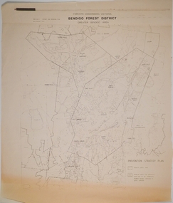
Map - CAMPBELL COLLECTION: BENDIGO AND DISTRICT MAPS, 1982
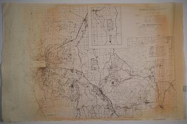
... CAMPBELL COLLECTION: BENDIGO AND DISTRICT MAPS...Map. Forest Commission Victoria, Bendigo Forest District...MAP Bendigo forest district Map. Forest Commission Victoria ...Map. Forest Commission Victoria, Bendigo Forest District, Greater Bendigo Area. Shire of Marong, Sailors Gully, Epsom, Borough of Eaglehawk, Jackass Flat, White Hills, California Gully, Shire of Huntly, Maiden Gully, Long Gully, North Bendigo, Bendigo East, City of Bendigo, West Bendigo, Kennington, Shire of Strathfieldsaye, Flora Hill, Quarry Hill, Golden Square, Kangaroo Flat, Spring Gully. Prevention Strategy Plan. Base prepared 1982.map, bendigo, forest district -
 Bendigo Historical Society Inc.
Map - CAMPBELL COLLECTION: BENDIGO AND DISTRICT MAPS
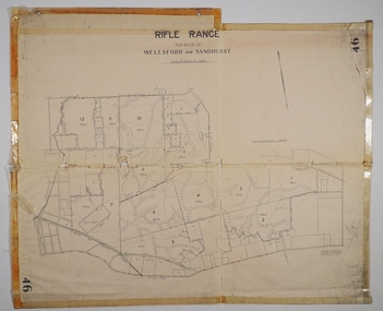
... CAMPBELL COLLECTION: BENDIGO AND DISTRICT MAPS...MAP Bendigo allotments Bendigo Rifle Range Sandhurst Parish ...Map. Rifle Range, Parishes of Wellsford and Sandhurst. Scale 20 chains to 1 inch. Total area in plan is 5916 acres. Wallan and Bendigo Railway to Axedale Township and station 8 miles, to Longlea Railway Station 2 1/2 - 3 miles. Rifle Range. Compiled in W.P.B. from Assessment and Parish Plans, by H.A.D. 8-7-29H.A.D.(Darby).map, bendigo, allotments, bendigo rifle range, sandhurst parish, wellsford parish -
 Bendigo Historical Society Inc.
Map - CAMPBELL COLLECTION: BENDIGO AND DISTRICT MAPS, 1959
... CAMPBELL COLLECTION: BENDIGO AND DISTRICT MAPS....Map. Huntly, County of Bendigo, Neilborough, Bagshot...MAP Bendigo allotments Huntly A.C. Brooks, Government ...Map. Huntly, County of Bendigo, Neilborough, Bagshot, Nerring, Wellsford, Sandhurst. Township of Huntly. By Authority A.C. Brooks, Government Printer Melbourne. Drawn and reproduced at the Department of Lands and Survey, Melbourne, 1958. Price 5/-.A.C. Brooks, Government Printermap, bendigo, allotments, huntly -
 Bendigo Historical Society Inc.
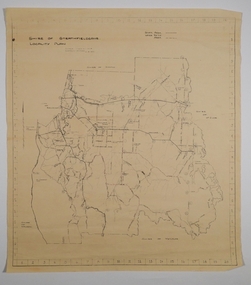
Map - CAMPBELL COLLECTION: BENDIGO AND DISTRICT MAPS
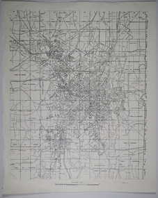
... CAMPBELL COLLECTION: BENDIGO AND DISTRICT MAPS....MAP Bendigo city streets Map. Parish of Sandhurst, Shire ...Map. Parish of Sandhurst, Shire of Strathfieldsaye, Mandurang Parish, Junortoun.map, bendigo, city streets -
 Bendigo Historical Society Inc.
Map - CAMPBELL COLLECTION: BENDIGO AND DISTRICT MAPS
... CAMPBELL COLLECTION: BENDIGO AND DISTRICT MAPS....Map. Eastern area of Bendigo, Parish of Huntly, Ascot...MAP Bendigo parishes Map. Eastern area of Bendigo, Parish ...Map. Eastern area of Bendigo, Parish of Huntly, Ascot, Shire of Huntly, Jackass Flat, Old White Hills, White Hills, Emu Point, North Bendigo, East Bendigo, Strathdale, Parish of Strathfieldsaye, Parish of Sandhurst, Parish of Wellsford.map, bendigo, parishes -
 Bendigo Historical Society Inc.
Map - CAMPBELL COLLECTION: BENDIGO AND DISTRICT MAPS
... CAMPBELL COLLECTION: BENDIGO AND DISTRICT MAPS....Map. Forest Commission Victoria, Bendigo Forest District...MAP Bendigo forest district Map. Forest Commission Victoria ...Map. Forest Commission Victoria, Bendigo Forest District, Basic information prepared 1982, scale 1:100,000. Fire Prevention Strategy Plan. Mitiamo, Greater Bendigo Area, Castlemaine F.D.map, bendigo, forest district -
 Bendigo Historical Society Inc.
Map - CAMPBELL COLLECTION: BENDIGO AND DISTRICT MAPS
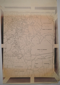
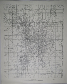
... CAMPBELL COLLECTION: BENDIGO AND DISTRICT MAPS....MAP Bendigo parishes Map. Parish of Sandhurst, Parish ...Map. Parish of Sandhurst, Parish of Huntly, Parish of Nerring, Parish of Marong, Parish of Lockwood, Parish of Wellsford, Parish of Strathfieldsaye, Parish of Mandurang. Scale approx 1:18,000.map, bendigo, parishes -
 Bendigo Historical Society Inc.
Map - CAMPBELL COLLECTION: BENDIGO AND DISTRICT MAPS
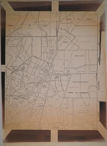
... CAMPBELL COLLECTION: BENDIGO AND DISTRICT MAPS....MAP Bendigo parishes Map. Sandhurst and suburbs, Parish ...Map. Sandhurst and suburbs, Parish of Sandhurst, Parish of Huntly, Parish of Nerring, Parish of Marong, Parish of Lockwood, Parish of Wellsford, Parish of Strathfieldsaye, Parish of Mandurangmap, bendigo, parishes -
 Bendigo Historical Society Inc.
Map - CAMPBELL COLLECTION: BENDIGO AND DISTRICT MAPS
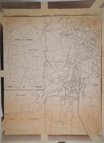
... CAMPBELL COLLECTION: BENDIGO AND DISTRICT MAPS....MAP Bendigo parishes Map. Parishes and suburbs : North ...Map. Parishes and suburbs : North of Bendigo, Parish of Huntly, Parish of Nerring, Parish of Sandhurst, Sydney Flat, Myers Flat, Borough of Eaglehawk, Sailors Gully, Jobs Gully, Harvey Town, California Gully, Maiden Gully, Long Gully, St.Just's Point, Iron Bark.map, bendigo, parishes -
 Bendigo Historical Society Inc.
Map - CAMPBELL COLLECTION: BENDIGO AND DISTRICT MAPS
... CAMPBELL COLLECTION: BENDIGO AND DISTRICT MAPS....MAP Bendigo parishes Map. South and West of Bendigo, Parish ...Map. South and West of Bendigo, Parish of Marong, Moonta, West Bendigo, Specimen Hill, Golden Square, Shire of Marong, Golden Gully, Kangaroo Flat, Diamond Hill, Shire of Strathfieldsaye, Crusoe, Parish of Lockwood.map, bendigo, parishes -
 Bendigo Historical Society Inc.
Map - CAMPBELL COLLECTION: BENDIGO AND DISTRICT MAPS, 21-8-1972
... CAMPBELL COLLECTION: BENDIGO AND DISTRICT MAPS...MAP Bendigo locality plan M.Higgs 21-8-1972 Map. Shire ...Map. Shire of Strathfieldsaye, Locality Plan. Scale I inch=1 mile. Shire of Huntly, Shire of McIvor, City of Bendigo, Shire of Marong, Shire of Maldon, Shire of Metcalfe. Lake Eppalock. Mileage markers on some roads. Melbourne to Bendigo Railway Line, Big Hill Tunnel, Mt.Herbert 1596.Axedale Township, Strathfieldsaye Township.M.Higgs 21-8-1972map, bendigo, locality plan -
 Bendigo Historical Society Inc.
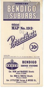
Map - Three Road Maps of Bendigo, 1962
... Three Road Maps of Bendigo...Three Road Maps of Bendigo, Bendigo and Suburbs, Bendigo... Bolton's Bendio Broadbent maps Three Road Maps of Bendigo, Bendigo ...George Robert Broadbent (1863-1947), cyclist and map publisher, was born on 3 November 1863 at Ashby near Geelong, Victoria, son of George Adam Broadbent, Lancashire-born draper, and his wife Elizabeth, née Ruffhead. When the family moved to North Melbourne Broadbent attended the Errol Street school, followed his father's trade, and became an early cycling and cycle-racing enthusiast. At various times Broadbent held most Victorian and Australian road records, and two of his performances on solid tyres—203 miles (327 km) in 24 hours on a penny farthing, and 100 miles (161 km) in 6 hours 20 minutes on a 'safety' bicycle—were never bettered. He established records for all distances between 130 and 220 miles (209 and 354 km), and for all times between 8 and 12 hours, at the Exhibition Grounds track in May 1894, and road records for 50 and 100 miles (80 and 161 km) in October 1896. The Australian Cyclist acknowledged him 'the finest road rider that Australia has ever produced'. A foundation councillor of the League of Victorian Wheelmen in October 1893, Broadbent contested the first Warrnambool-Melbourne race in 1895, and was active in the Good Roads Movement. Next year he issued a road map of Victoria, 'prepared … after some sixteen years riding and touring in all parts of the Colony', which indicated general topography, distances, and roads classified as 'good', 'fair' or 'ridden with difficulty'. It was to become Victoria's standard map, and the basis of a continuous publishing programme by Broadbent's Official Road Guides Co.Three Road Maps of Bendigo, Bendigo and Suburbs, Bendigo and Eaglehawk. Two fold out maps printed in colour and produced by Broadbent's Road Maps Pty. Ltd. 475 Collins Street Melbourne. One map printed by Bolton's Bendigo.history, bolton's, bendio broadbent maps -
 Ballarat Tramway Museum
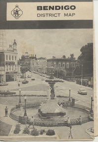
Map, Royal Automobile Club of Victoria, "Bendigo District Map - RACV", c1971
... "Bendigo District Map - RACV"...Printed street map titled "Bendigo District Map", published...in ink on the Bendigo Outlet map, "3/4" along bottom edge.... Parade Ballarat Ballarat goldfields Trams tramways Map Bendigo ...Printed street map titled "Bendigo District Map", published by the RACV, showing the central part of Bendigo, Bendigo Outlets, streets, principal attractions, Bendigo and district maps and information, and a list of sporting and entertainment facilities. Has the tram lines shown dotted, only shows the full extent of the Golden Square line. The main map has the number "0171" in the bottom left hand corner, indicating the publication date.in ink on the Bendigo Outlet map, "3/4" along bottom edge.trams, tramways, map, bendigo, racv, railways -
 Bendigo Historical Society Inc.
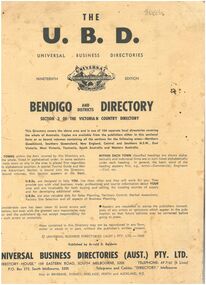
Booklet - The Universal Business Directory (UBD)
... Bendigo maps... Traders section, emergency phone numbers and maps of Bendigo... Bendigo Businesses Bendigo maps 1960s Bendigo Business Directory ...The Nineteenth Edition of the Bendigo and Districts Universal Business Directory, which is Section 3 of the Victorian Country Directory for 1969. The directory includes classified sections for Bendigo and surrounding towns, including Carisbrook, Castlemaine, Eppalock, Harcourt, Malmsbury, Maryborough, Newbridge, Raywood, Tooborac and Yapeen. It also includes an Eaglehawk Traders section, emergency phone numbers and maps of Bendigo, Castlemaine, Kangaroo Flat and Maryborough. The booklet is made of soft flimsy paper with black print and contains 51 pages.There is a grey lead scribble on back page between the '6' and '7'.bendigo businesses, bendigo maps, 1960s, bendigo business directory -
 Melbourne Tram Museum
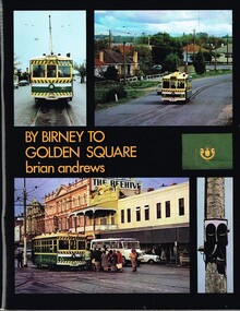
Book, Brian Andrews, "By Birney to Golden Square", 1973
... routes marked in and a fold out detailed map of Bendigo and its... Trams tramways SECV Tramways Bendigo Maps Book, 78 pages ...Book, 78 pages including card cover, printed on gloss paper, titled "By Birney to Golden Square", written by Brian Andrews, published by Southern Cross Traction, Kensington Park SA. Sub-titled "The last years of Bendigo's tramways", 1973. Features both black and white and colour photographs, including tickets, photos along each route, Charing Cross, depot, notes on the rolling stock with an aerial photograph of Bendigo with the tram routes marked in and a fold out detailed map of Bendigo and its track layout.trams, tramways, secv tramways, bendigo, maps -
Bendigo Historical Society Inc.
Photograph - Aerial shots of parts of Bendigo 1934, 1934
... bendigo maps... history bendigo bendigo mines bendigo maps bendigo aerial photos ...AERIAL SHOTS OF PARTS OF BENDIGO 1934 Catalogue No.10584 This document contains scans of a unique set of aerial photographs that were taken over the City of Bendigo on Friday 12th January 1934, at about midday. The photographs were commissioned by Bendigo Mines Limited during their exploration and mining program designed to revitalize the Bendigo Goldfield. The photographs were given to the Victorian Mines Department sometime in the 1950s. The photographs were taken at a relatively low level of about 4000 feet. This gives a very detailed picture of Bendigo as it was in the 1930s. The photos cover the City Centre and are mainly of the goldfields on the south side of the city; the extent of which covers approximately the four corners of Myers Flat, Maiden Gully, Mandurang and One Tree Hill. Streets, roads and places of interest have been identified as best as possible in December 2023. There are 44 maps, and each references the adjoining maps.Typed Notes with CD The CD is one of two and contains a set of 46 images: The folder named "High_Resolution_800dpi" contains the original digital files that were produced by scanning the photographic prints (About A3 size) at 800 dpi using a high quality, large pformat, roll scanner. These files may be too large for some computers. A second CD contains a direstory called "Low_Resolution_300dep" The images in the folder names "Low_Reolution_300dpr" have a lower resolution (300 dpi) and have been rotated 90 degrees clockwise so that the Northern margin of each image is a the top of the screen. Clive Willman Senior Geologist Geological Survey of Victoriahistory, bendigo, bendigo mines, bendigo maps, bendigo aerial photos -
Bendigo Historical Society Inc.
Map - BENDIGO AND DISTRICT PARISH MAPS, 21-10-26
... BENDIGO AND DISTRICT PARISH MAPS...Map. Sandhurst, County of Bendigo, City of Bendigo... Inc. History House 11 Mackenzie Street Bendigo goldfields MAP ...Map. Sandhurst, County of Bendigo, City of Bendigo, Strathfieldsaye, Mandurang, Marong, Nerring, Borough of Eaglehawk, Township of Kangaroo Flat, Lockwood, Huntly, Epsom, Wellsford. By Authority H.J. Green, Government Printer, Photo-Lithographed at the Department of Lands and Survey, Melbourne bj W.J Butson 21-10-26,Price 1/-. (number 13 in map cupboard 1)By Authority H.J. Green, Govt. Printermap, bendigo, sandhurst -
 Bendigo Historical Society Inc.
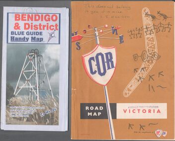
Map - Road maps
... Two road maps. On, Bendigo & District blue guide handy map...On the back of the Bendigo map the date October 2000... Collection Road Map Victoria Bendigo On the back of the Bendigo map ...BHS CollectionTwo road maps. On, Bendigo & District blue guide handy map the other a road map of Victoria. On the back of the Bendigo map the date October 2000. On the Victoria map the words in pen "This doesn't belong to you, it is mine". L.J. Ellison and a blue stamp of Axedale service station. Aileen and John Ellison Collection.road map, victoria, bendigo -
 Bendigo Historical Society Inc.
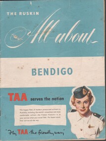
Booklet - Tourist guide, 1956
... Bendigo maps... Advertising Services Bendigo businesses Bendigo maps The Ruskin All ...The Ruskin All-About Bendigo Booklet produced for the 1956 Melbourne Olympics. Includes maps and facts, service organizations and businesses in Bendigo. Includes advertisements for Australian companies. TAA on the cover. Produced by Ruskin Publishing Pty Ltd 37 Swanston St. Melbourne.advertising, services, bendigo businesses, bendigo maps -
 Bendigo Historical Society Inc.
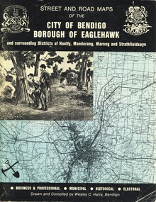
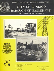
Book - STREET AND ROAD MAPS OF THE CITY OF BENDIGO BOROUGH OF EAGLEHAWK, c1980
... bendigo & district maps...Street and Road Maps of the City of Bendigo Borough... Bendigo bendigo & district maps Bendigo and Districts map ...Street and Road Maps of the City of Bendigo Borough of Eaglehawk and surrounding Districts of Huntly, Mandurang, Marong and Strathfieldsaye, in color. Drawn and compiled by Wesley C Harry, Bendigo. Publisher: Cambridge Press, Bendigo. ISBN: 9598608.2.2. 68 pages. Photographs, Illustrations & maps. Photos include: Bendigo buildings, scenery mines, streetscapes, parades, pioneer leaders of Bendigo. Many advertisements throughout. List of Justices of the Peace, hospitals, homes for the aged, schools, churches. Page 58: Copy of ''Freedom of the City to the Australian Survey Regiment'' proclamation, 14th June 1970. Maps cover an area of some 169 sq. miles (43,772 hectares). Origin of the name Bendigo. Information on the five Wards of Bendigo, and their councilors.Wesley C Harrybook, bendigo, bendigo & district maps, bendigo and districts map, buildings, streetscapes, historical pictures, advertisements, historical information, commisioners camp, sandhurst -
 Bendigo Historical Society Inc.
Book - STREET AND ROAD MAPS OF THE CITY OF BENDIGO BOROUGH OF EAGLEHAWK, c1980
... bendigo & district maps...Street and Road Maps of the City of Bendigo Borough... Bendigo bendigo & district maps Bendigo and Districts map ...Street and Road Maps of the City of Bendigo Borough of Eaglehawk and surrounding Districts of Huntly, Mandurang, Marong and Strathfieldsaye, in color. Drawn and compiled by Wesley C Harry, Bendigo. Publisher: Cambridge Press, Bendigo. ISBN: 9598608.2.2. 68 pages. Photographs, Illustrations & maps. Photos include: Bendigo buildings, scenery mines, streetscapes, parades, pioneer leaders of Bendigo. Many advertisements throughout. List of Justices of the Peace, hospitals, homes for the aged, schools, churches. Page 58: Copy of ''Freedom of the City to the Australian Survey Regiment'' proclamation, 14th June 1970. Maps cover an area of some 169 sq. miles (43,772 hectares). Origin of the name Bendigo. Information on the five Wards of Bendigo, and their councilors. Revised Edition 1986Wesley C Harrybook, bendigo, bendigo & district maps, bendigo and districts map, buildings, streetscapes, historical pictures, advertisements, historical information, commisioners camp, sandhurst -
 Ballarat Tramway Museum
Book, Brian Andrews, "By Birney to Golden Square", 1973
... with the tram routes marked in and a fold out detailed map of Bendigo... detailed map of Bendigo and its track layout. Yields information ...Features both black and white and colour photographs, including tickets, photos along each route, Charing Cross, depot, notes on the rolling stock with an aerial photograph of Bendigo with the tram routes marked in and a fold out detailed map of Bendigo and its track layout.Yields information about the Bendigo tramways operated by the SEC in a photographic and text format.Book, 78 pages including card cover, printed on gloss paper, titled "By Birney to Golden Square", written by Brian Andrews, published by Southern Cross Traction, Kensington Park SA. Sub-titled "The last last years of Bendigo's tramways", 1973. trams, tramways, bendigo, sec tramways, maps -
 Bendigo Historical Society Inc.
Book - STREET MAPS AND BUSINESS DIRECTORY OF THE CITY OF BENDIGO, c1972
... bendigo & district maps... Bendigo bendigo & district maps streets & localities Bendigo ...Street Maps and Business Directory of the City of Bendigo Borough of Eaglehawk and Surrounding District : with Classified Business Directory (1973). Drawn and compiled by Wesley C Harry. Publisher: Cambridge Press, Bendigo. 88 pages. Includes b/w photographs, illustrations & maps. Information on the shires that make up Bendigo. History of the name of Bendigo. Historical pictures with notes. Advertisements for local businesses. Signed - Alec S Craig, mayor. Grace A. O. CraigWesley C Harrybook, bendigo, bendigo & district maps, streets & localities bendigo & district, businesses, historical notes of bendigo -
 Ballarat Tramway Museum
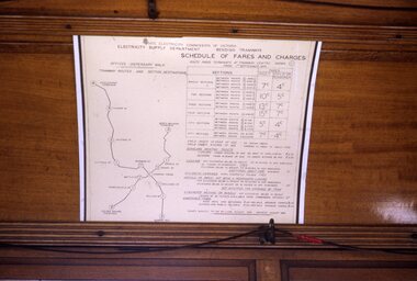
Slide - 35mm slide/s, Peter Moses, Jan. 1969
... On the rear of the slide "Jan. 1969 Bendigo/ Map of Routes... Bendigo/ Map of Routes" in blue ink, "P. Moses" in black ink ...Photo of the SEC Bendigo "Schedule of Fares and Charges" inside a tram. The fare chart appears to have been mounted on a large sheet of white cardboard. Note the red tape joining the bell cord. Kodak cardboard mount slide, taken by Peter Moses, Jan. 1969.On the rear of the slide "Jan. 1969 Bendigo/ Map of Routes" in blue ink, "P. Moses" in black ink and other side of the slide in red ink “1”.tramways, trams, bendigo, schedule of fares, map, fares -
Bendigo Historical Society Inc.
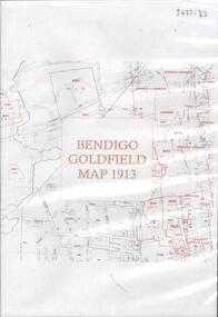
Map - BENDIGO GOLDFIELD MAP 1913
... BENDIGO GOLDFIELD MAP 1913...CD, Bendigo Goldfield Map 1913...., Bendigo Goldfield Map 1913. Map BENDIGO GOLDFIELD MAP 1913 ...CD, Bendigo Goldfield Map 1913. -
 Bendigo Historical Society Inc.
Map - BENDIGO GOLDFIELD MAP 1913, 1913
... BENDIGO GOLDFIELD MAP 1913...DVD. Bendigo Goldfield Map 1913....DVD. Bendigo Goldfield Map 1913. Map BENDIGO GOLDFIELD MAP ...DVD. Bendigo Goldfield Map 1913. -
 Bendigo Historical Society Inc.
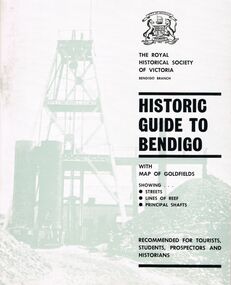
Book - HISTORIC GUIDE TO BENDIGO
... of Victoria Bendigo Branch Historic Guide to Bendigo with map... Branch Historic Guide to Bendigo with map of goldfields showing ...Three books titled ' The Royal Historical Society of Victoria Bendigo Branch Historic Guide to Bendigo with map of goldfields showing streets, lines of reef, principal shafts. Recommended for tourists, students, prospectors and historicans.' Sixth Edition. Cambridge Press, Bendigo. Maps, photos, diagrams.bendigo, history, gold mining, book, books, bendigo, bendigo history, victoria, victorian history, australian history, gold, gold fields, the royal historical society of victoria, gold discoveries