Showing 74 items
matching bendigo showgrounds
-
 Victorian Harness Racing Heritage Collection at Lord's Raceway Bendigo
Clothing - Race Colours, Gordon Rothacker
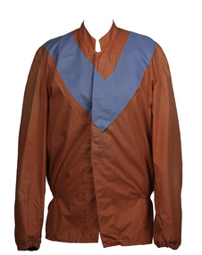
Gordon Rothacker died in 2010 at the age of 81. Harness Racing Victoria's (HRV) highest individual award, the Gordon Rothacker Medal, is named in his honour. Rothacker won a record 14 Melbourne drivers' premierships between 1949 and 1973 as well as capturing 10 Melbourne trainers' premierships between 1953 and 1976. He was the first reinsman to land 500 winners on Melbourne tracks, doing so at Moonee Valley in 1987 some 39 years after driving his first winner at the Royal Melbourne Showgrounds as an 18-year-old in the inaugural season of night trotting. Awarded an MBE in the Queen's Birthday honours of 1972 for his services to trotting, Rothacker was the Caduceus Club's first living legend when inducted in 1995 and has also been awarded the Distinguished Service Medal by HRV. He won numerous feature races with the likes of Angelique, Rhett, Gallagher and Raiarmagh Pool and also represented Australia in the second World Drivers' Championship in 1971 in the US and Canada.Red with blue Vrothacker, trotting, gallagher, angelique, showgrounds, premiership, rothacker medal, g rothacker, gordon rothacker, gw rothacker -
 Victorian Harness Racing Heritage Collection at Lord's Raceway Bendigo
Clothing - Race Colours, John Phyland and Ced McLean
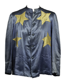
John Phyland It was during 1890 to 1918 that John Phyland, son of Irish immigrants, born in 1866, ran a 2000-acre sheep station. The property, Lake Vale, was south of Balranald, towards the Murray River town of Swan Hill. This would seem to be an unlikely location for a harness racing breeding operation, being more than 400km from Melbourne, where harness racing was centred on the Richmond track. But, undeterred by distance, Phyland purchased his first trotter in 1882 and proceeded to acquire expensive, high quality standardbred mares and stallions and embark on a venture that saw him: • Breed and race winners of major races including The Melbourne Thousand, Bendigo JC Handicap (raced almost continuously on the grass track at Epsom, Bendigo, from 1867 to 1946), Boort Cup and numerous races at the Melbourne metropolitan tracks at Richmond and Ascot; • Acquire Soultline Villa and training stables adjacent to the Royal Melbourne Showgrounds so he could race at metropolitan tracks; • Develop a large self-contained training facility (including resident blacksmith) and home at 19 Raleigh St, Essendon; • Become the chair of the Victorian Trotting Horse Owners and Breeders’ Association, which lobbied strenuously for night trotting in the 1930s; • Breed from imported and locally bred mares that left families that are still active today. Heaven Rocks, the Ballarat Cup, New Zealand Jewels three and four-year-winner, and 1:49.6 ($554,529) export to the US, is six generations on from the Phyland bred mare Dusky Ribbons; • Saw the start of the training career of colourful and controversial Cedric (Ced) McLean, Phyland’s son-in-law, with a mare left when Phyland died.Blue with yellow starsbalranald, trotting, phyland, richmond trotting -
 Victorian Harness Racing Heritage Collection at Lord's Raceway Bendigo
Vehicle - Glasheen's Race sulky, Paddy Glasheen's Grand Voyage sulky
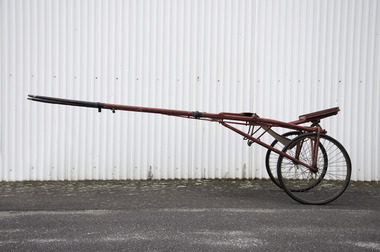
Race sulky used on Hall of Fame trotter Grand Voyage by trainer-driver Paddy Glasheen. Passed on to his son Jack and then to grandson Fr Brian Glasheen. From Historian John Peck: This article was on page 2, 19th May 1954. Reading the article it seems to me that the sulky is celebrating its centenary birthday in 2021. GRAND VOYAGE'S SULKY When Major Miracle won a race at the Melbourne meeting on Friday night he was attached to a very historic sulky, the being none other than the one which Grand Voyage pulled to success on many occasions. Made in New Zealand to the order of the late Paddy Glasheen during a trip to the Dominion late in 1921 with the famous trotter, the vehicle is thus over 32 years old. Constructed of hickory, it is now owned by Jack Glasheen, the son of the late Paddy figuring as the trainer and driver of Major Miracle.This sulky was purchased by trainer Paddy Glasheen during Grand Voyage’s New Zealand campaign in 1922. It was also used by Paddy’s son Jack Glasheen who trained at Preston. The Jack Glasheen trained Major Miracle won 8 races at the Showgrounds using this sulky. Owned and trained at Belmont Stud, Pitt St Huntly (Bendigo), Grand Voyage was an outstanding Australian trotter. Some claim he was greater than Fritz and the equal of Maoris Idol. Foaled in New South Wales in 1913, and trained and driven throughout his career by Paddy Glasheen, Grand Voyage commenced his preparation at the tender age of nine months at Glasheen and Busst’s Belmont Stud Farm Pitt St. Huntly. By a prolific sire of trotters in First Voyage, Grand Voyage was from Blonde Grattan (imported by the Tye brothers), a daughter of the great Canadian sire Grattan. Grand Voyage’s reputation preceded him to the racetrack, and when he was produced for the main Victorian classic for young trotters, the Futurity Stakes, all of his opposition had pulled out of the race except one rival, whom he beat at 20 to 1 on in the first heat and again disposed of easily in the second heat, in which there was no betting. The potential of Grand Voyage was recognized by all, including the handicapper who saw to it that the black champion won no race easily. After his Futurity win, Grand Voyage was spelled and did a light season of stud duty. At his second start, in January 1917, the three-year-old won from 60 yards behind against older horses at the Richmond (Melbourne) track in a time barely slower than in which the Richmond Cup, run the same day, was decided. In subsequent starts he raced from 85 and 115 yards behind, the latter occasion producing another fantastic winning performance. As a rising five-year-old Grand Voyage defeated the hoppled pacers for the first time, subsequently a common sight. In June 1919 he won twice on the day at Epping (Harold Park) in Sydney, each time setting a record, then at the Melbourne Showgrounds where he set a mile record of 2:16 3/5 after a tremendous battle from even marks with the very good pacer Sarilla the winner of 23 races at Ricmond. In 1921, back in Sydney, Grand Voyage reduced the winning record at Epping to 2:13. Grand Voyage won the first Boort Pacing Cup in 1921, starting from 280 yards behind ! 1921 BOORT CUP – 50 pounds – One & half miles GRAND VOYAGE**, 280yds (P Glasheen) 1 Red Rock, scr (I Kelly) 2 Mayfield, 75yds (M Quinn) 3 Others: Artist (scr), maxim Direct (scr), Road King (scr), Emmie Direct (75yds), Tearaway (165yds), Straightaway (195yds) **Raced as Bonnie Voyage Margins: 6 lgths X 10 lgths Time: 3m 54s He was then taken to New Zealand. His 1922 Otahuhu Cup worth 1000 Sovereigns ($2000) against the best New Zealand pacers from 48 yards in a race record 4:31 3/5 was considered by Glasheen his most outstanding effort. On return from New Zealand, he won further races including the original Bendigo Cup at the Bendigo Jockey Club track at Epsom. In all, Grand Voyage won 37 races, driven in all of them by Glasheen.Race Sulky from 1910-20 era, purchasedd in New Zealand, used on Hall of Fame Trotter Grand Voyage by Paddy GlasheenPainted deep red.trotting, grand voyage, paddy glasheen, sulky, belmont stud, jack glasheen, brian glasheen, harnes racing -
 Victorian Harness Racing Heritage Collection at Lord's Raceway Bendigo
Photograph - Framed photo finish, Maori Miss, 4 May 1963
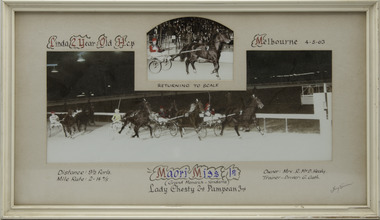
Maori Miss won the Linda 2 Year Old Hcp at Melbourne Showgrounds on the 4 May 1963, followed by Lady Chesty and Pampean. Maori Miss owned by Mrs R McD Healy, was trained and driven by G Gath. Maori Miss raced from 1963 (2yo) through to 1967 (6yo). Career: 20 wins 12 seconds 10 thirds 63 starts. Refer to Identifier 15.190 (Media) for Full Career Performance Record.Two colour photographs, one small one large in a white frame. At the top: Linda 2 Year Old Hcp/ Melbourne / 4-5-63 / Returning to Scale At the bottom: Left corner: Distance 9 1/2 furls / Mile rate 2 -14 4/5 Centre: Maori Miss 1st (Grand Monarch - Yendarra) / Lady Chesty 2nd / Pampean 3rd Right corner: Owner Mrs R McD Healy / Trainer - Driver G Gathhorses, race, winner, driver, trainer, owner, 1963, maori miss, melbourne, showgrounds, g gath, mrs r mcd healy, lady chesty, pampean, george gath, r healy, r mcd healy, ric healy -
 Victorian Harness Racing Heritage Collection at Lord's Raceway Bendigo
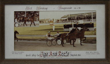
Photograph - Framed photo finish, Jigs And Reels, 14 January 1978
Jigs And Reels won the Kick Handicap at Melbourne Showgrounds on the 14 January 1978, followed by Quick Whip and Kazibob. Jigs And Reels owned by Mr G Harrison, was trained and driven by K Allen. Jigs And Reels raced from 1975 (3yo) through to 1979 then went to US and raced until 1985 (13yo). Career: 29 wins 22 seconds 20 thirds 216 starts.Two colour photographs, one small one large in a brown frame. At the top: Kick Handicap/ Showgrounds / 14-1-78 At the bottom: Left corner: Distance 2538 Metres / Kilo rate 1-22-4 Centre: Quick Whip 2nd /Jigs And Reels (Delvin Dancer - Canny Rose) / Kazibob 3rd Right corner: Owner Mr G Harrison / Trainer - Driver K Allenhorses, race, winner, driver, trainer, owner, melbourne, showgrounds, 1978, jigs and reels, k allen, mr g harrison, quick whip, kazibob -
 Victorian Harness Racing Heritage Collection at Lord's Raceway Bendigo
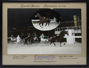
Photograph - Framed photo finish, Lynmont, 16 November 1968
Lynmont won the Lansell Stakes at Melbourne Showgrounds on the 16 November 1968, followed by Adios Green and Timothy Scott. Lynmont owned by Mrs C Inglis, was trained and driven by KW Wills. Two colour photographs, one small one large in a black frame. At the top: Lansell Stakes/ Melbourne / 16-11-68 At the bottom: Left corner: Distance 12 1/2 furls / Mile rate 2 -8 2/5 Centre: Lynmont 1st (Gay Reveller - Free Lass) / Adios Green 2nd / Timothy Scott 3rd Right corner: Owner Mrs C Inglis / Trainer - Driver KW Willshorses, race, winner, driver, trainer, owner, melbourne, showgrounds, 1968, lynmont, kw wills, mrs c inglis, adios green, timothy scott, ken wills -
 Victorian Harness Racing Heritage Collection at Lord's Raceway Bendigo
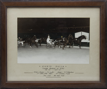
Photograph - Framed photo finish, Gaby's Dalla, 20 January 1951
Gaby's Dalla won the Cooinda Handicap at Melbourne Showgrounds on the 20 January 1951, followed by John's Pride and Glimpse. Gaby's Dalla owned by HJ Robertson, was trained and driven by TC Taylor. One large colour photograph in a brown frame. At the top: Gaby's Dalla / Cooinda Handicap at RMS / 12 1/2 Fur / 20-1-51 In the middle: Left side: Driver - Trainer TC Taylor / 2nd John's Pride - Neck Right side: Owner HJ Robertson / 3rd Glimpse - 4 yds At the bottom: Time - 3.32 / Mile Rate 2-15 1/5horses, race, winner, driver, trainer, owner, melbourne, showgrounds, 1951, gaby's dalla, tc taylor, hj robertson, john's pride, glimpse -
 Victorian Harness Racing Heritage Collection at Lord's Raceway Bendigo
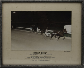
Photograph - Framed photo finish, Adrian Boddington, Dandy Don, 26 December 1953
Dandy Don won the Payne Handicap at Melbourne Showgrounds on the 26 December 1953. Dandy Don owned by Mr RR Cochrane, was trained by T Taylor and driven by H Taylor. One large coloured photograph in a black frame. Top line: "Dandy Don" Second line: Payne Handicap / Melbourne Showgrounds Third line: 12 1/2 furlongs / 26-12-53 Fourth line: Owner Mr RR Cochrane / Trainer T Taylor / Driver H Taylor Fifth line: 2nd Kaye Lois 4 yds / 3rd Lady Armat 3 yds Bottom line: Time 3.31 3/5 / Mile Rate 2.15 3/5 Under photo right corner: Adrian Boddingtonhorses, race, winner, driver, trainer, owner, melbourne showgrounds, 1953, dandy don, t taylor, h taylor, mr rr cochrane, kaye lois, lady armat -
 Victorian Harness Racing Heritage Collection at Lord's Raceway Bendigo
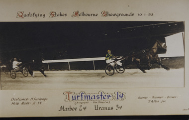
Photograph - Framed photo finish, Turfmaster, 10 January 1953
Turfmaster won the Qualifying Stakes at Melbourne Showgrounds on the 10 January 1953, followed by Marboe and Uranus. Turfmaster owned, trained and driven by T Allen Jnr. One large colour photograph in a white frame. At the top: Qualifying Stakes / Melbourne Showgrounds / 10-1-53 At the bottom: Left corner: Distance 11 furlongs/ Mile rate 2.14 Centre: Turfmaster 1st (Kings Gift - Vin Direct) / Marboe 2nd / Uranus 3rd Right corner: Owner Trainer Driver T Allen Jnrhorses, race, winner, driver, trainer, owner, melbourne showgrounds, turfmaster, t allen jnr, marboe, uranus -
 Victorian Harness Racing Heritage Collection at Lord's Raceway Bendigo
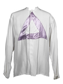
Clothing - Race colours, I.R. (Dick) Lee
Dick Lee is a prolific Group 1 winning trainer and driver, successful breeder and owner, International and trotting pioneer, outstanding administrator and tireless volunteer. Dick Lee, son of a soldier-settler was a track ranger at the Melbourne Showgrounds before accepting a position as a private trainer in the emerging trotting industry in Wales, taking a team of horses to the UK where he had 105 drives for 29 wins. The adventure would also see him compete in Holland, Germany, Sweden, Belgium, Russia and the US, always with trotters. He returned to Australia in 1970 with “a wife, a trainer-driver premiership, half-a-dozen miniature Irish donkeys and a horse in tow”. The horse, Hermes, would sire 1976 Melbourne Cup winner Van Der Hum. Dick served 12 years as president of the Victorian Square Trotters Association to advocate for the gait. Emerging from this time are: 1985 The Redwood Classic for 2yo trotters 1996 the first all-trotting card, the Redwood Day at Maryborough. Dick Lee’s training and driving produced among others: Bendigo and Melbourne Pacing Cups winner Rhodonite Australian Trotters of the Year Hampdens Pride and Game Ebony V L Dullard Cup winners Glenfield Girl and Game Ebony Rufus Youngblood, whose racing career included 32 wins, 23 seconds and 18 thirds from 139 starts, the first Australian-bred horse to win four Derbies and Australian Horse of the Year in 1987. Dick Lee was inducted into the Victorian Harness Racing Hall of Fame in 2019White race colours with purple triangle pointing upbendigo, bendigo cup, lord's raceway, dick lee, rhodonite, bendigo harness racing club, bhrc, race colour, hall of fame, ir (dick) lee, ir lee -
 Victorian Harness Racing Heritage Collection at Lord's Raceway Bendigo
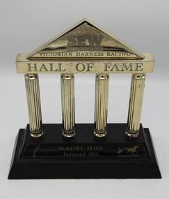
Memorabilia - Engraved glass plaque, Maori Miss, 2014 Victorian Harness Racing Hall of Fame Award
Maori Miss (Grand Monarch NZ P 2.9.2 - Yendarra Hall NZ - (Loreto)) Brown Mare. Foaled 1960 (2nd Foal). Breeder/Owner: R McD Healy. Trainer G Gath. Maori Miss raced from 1963 (2yo) through to 1967 (6yo). Career: 20 wins 12 seconds 10 thirds 63 starts 2.10.6 Winning Drivers: G Gath (13) Neville Gath (6) BR Gath (1). Won on 8 Tracks: Melbourne Showgrounds (6) Harold Park NSW (2) Ballarat (4) Warragul (3) Geelong (2) Bendigo (1) Stawell (1) Cranbourne (1)2014 Victorian Harness Racing Hall of Fame Inductee Maori Miss. Australian Broodmare of the Year in 1977, 1978 and 1979. Dam of: Maori's Gift, Maori's Pride, Maori Monarch, Maori's Wonder, Maori's Idol, Maori Mara, Maori Way, Maori Mia, Maori Maid, Maori Trump, Maori Meadow. Gold Column shaped Trophy on a Wooden BaseSEW / Eurodrive / Victorian Harness Racing / Hall of Fame / Maori Miss / Inducted 2014maori miss, hall of fame, 2014, inductee, victoria harness racing, g gath, george gath, ric healy, neville gath, ng gath, r healy, r mcd healy -
 Victorian Harness Racing Heritage Collection at Lord's Raceway Bendigo
Document - Record, Harness Horse, Avian Again
Stephen Spark compiled horses performance records starting in 1983 on his typewriter. Avian Again: Riverina Herald, Tuesday August 19, 1952 Mr Harry Holmfield's pacer Avian Again made a spectacular return to racing on Saturday night at Harold Park when he took one of the main races in ; his first appearance this season. Bookmakers were ready for his visit to Sydney for they did not bet better than 6/4 On. The Ech uca owned horse, driven by Gor don Rothacker, was never in danger and led almost through out to score comfortably by over one length. Sky Pilot, the N.Z. pacer, who has won his last three races at Harold Park, challenged at one stage but was easily beaten off. Mr Holmfield is very impress ed with trotting in Sydney where the attendances eclipse those at the galloping meetings in the day. Avian Again's race on Saturday night was worth ,£600—£450 to the winning own er. 'Next month there will be a race with six heats worth £700 each and £2500 for the final. It is likely that Avian Again in this race will strike his half-brother, the famous Avian Derby, who Has not been retired to the stud as expected. Next week Avian Again will race in the fastest class at Har old Park from the scratch mark. He has yet to appear at the. Melbourne Showgrounds and has been shrewdly placed. . Later in the season he will be taken to Perth where the Inter Dominion championships will, be held in February.Avian Again raced from 1951 (4yo) through to 1957 (10yo). Had a Winning Streak of 8 wins. Career: 31 wins 12 seconds 13 thirds 83 starts.Typed document in black and red ink.harness racing, australasian harness racing, horse career, performance records, bendigo harness racing club, bhrc, avian again, he holmfield, g rothacker, wc rothacker, gordon rothacker, bill rothacker, harry holmfield, gw rothacker -
 Bendigo Historical Society Inc.
Document - Hustlers, Sheepshead and Deborah lines of reef
Albert Richardson was a mining historian who wrote widely on the mines of the Bendigo Goldfield. The park opposite the Goldmines Hotel in Marong Road, is named in his honour. Five page document, hand written by Albert Richardson on lined foolscap and edited with cross-outs and insertions, . The mines along the Hustlers line of reef and the Sheepshead line of reef are described. Mines listed on Hustlers line of reef: Fortuna Hustlers (1888 - 1913), shaft 2,240 feet at rear of Buckell and Jeffrey's offices; Royal Hustlers Reserve No. 2 - two shafts 'City" 860 feet, now covered by R.S.L. building Pall Mall, steel poppet legs 60 ft high and 'Park Shaft" at rear of Camp Hill School, 1,775 feet, steel poppet legs 60 feet high; Hustlers Hill Group first worked by Jonathan Harris in 1853 and bounded by Valentine, Anderson and Ironbark Creek to the north and Milroy Street to the east, one of first areas worked for quartz reefing. It with Garden Gully line west and Victoria Hill Ironbark, formed by far the richest cross section of the Bendigo Goldfield. Great Extended Hustlers (1865-1921) close to intersection of Anderson Street and Hustlers Road, mullock heap against road and shored up around shaft, steel poppet legs now at Wattle Gully mine, Chewton, large winding machine, air compressor south of shaft and 36 head crushing battery. Hustlers Reef (Old Hustlers) and Hustlers Reef No. 1, two shafts, main 2,210 feet, about 220 yards east of Moran Street and against Fenton Street. , No. 1 shaft 1,140 feet and about 155 yards east of Moran Street. Lansell's Comet, Lightining Hill line, 2.100 feet, on Comet Hill approx 70 yards west of Holmes Road, near Comet Creek, steel poppet legs. United Hustlers and Redan (1876-1918), main Redan, 1,830 feet about 155 yards west of Sandhurst Roead, in line with Comet Hill State School, this hill known as Redan Hill. North, or New Hustlers, once known as Agnew Hustlers, wooden poppet legs, south side, Kneebone Street, Eaglehawk. Derby line, Johnson's No. 3, South Johnson's (east shaft of Collman and Tacchi) 439 feet on west wide of Woods Street, south of Wetherall Street. Paddy's Gully Line, south to north, some shafts - Lansell's 'Sandhurst" ('Needle") Eaglehawk Road shaft 2,425 feet, about 50 yards east of Needle Loops, a brick square sided chimney with Cleopatra Needle top. British American, 789 feet, just south of Holdsworth Road. Collman and Tacchi, main shaft 2,588 feet, 60 yards west of Eaglehawk Road, California Gully. Deborah Line of Reef, The Deborah (1932-1954) shaft 2.017 feet, west of Adams Road and south of Abel Street, Quarry Hill. North Deborah (1937 - 1954) shaft 1,151 feet, Breen Street, Quarry Hill, steel poppet legs. Central Deborah (1939-1954) shaft 1,347 feet Sheepshead line of reef, Lansell's South Red, White and Blue, shaft 2,124 feet, north east of Bellevue Road and 220 yards east of Adams Road. The New Red, White and Blue Consolidated (Big Blue) main shaft 2,416 feet. Lansell's Bendigo Battery 105 head, north of 'Big Blue" on his freehold lease, commenced crushing on 24th February 1895. After closing was erected as the Showground's Industrial Hall, July 1926. North Red, White and Blue, burnt down February 1926, new company 1934, closed 1938. Document is part of the Albert Richardson Collection of Bendigo mining history. bendigo, gold mining, deborah line of reef, sheepshead line of reef, hustlers line of reef, royal hustlers reserve mine, hustlers hill group of mines, great extended hustlers, hustlers reef no. 1, lightning hill line, old comet, collman and tacchi, lansell's comet, north deborah, central deborah, dhrrpdhrsf linr og trrg, new red, white and blue consolidated mine, big blue, lansell's bendigo battery, north red, white and blue mine, albert richardson collection -
 Bendigo Historical Society Inc.
Map - LONG GULLY HISTORY GROUP COLLECTION: MAP OF LONG GULLY/CALIFORNIA GULLY AREA
BHS CollectionTwo copies of a map, printed on yellow paper, of the Long Gully/California Gully Area. It shows Eaglehawk Road from Craig Street then Mr Korong Road,to the Murray Valley Highway to just past Avenue Street. Sandhurst Road and Holmes Road are to the right. To the left is California Gully Road. Water Supply Purposes Reserve, Mental Hygiene Authority, Comet Hill State School Reserve, Agricultural Showgrounds and Recreation Reserve, Rubbish Reserve and two un-named State Schools are shown. Some contours are also shown.bendigo, history, long gully history group, the long gully history group - map of long gully/california gully area