Showing 602 items matching "breakwater history"
-
 Glenelg Shire Council Cultural Collection
Slide - AGFA Colour Slide - Portland Bay, c. 1960
Taken by Mr P.G.W. (Wal) Whitelaw in the early to mid 1960'sAgfacolor slide of Henty Beach, Portland bay lookings toward's Fiasherman's Breakwater. Portland Surf Lifesaving Club building on left (white building with red roof)Front: Portland Harbour - blue biro -
Glenelg Shire Council Cultural Collection
Memorabilia - Sticker, n.d
Formerly Bower Bird Museum, HeywoodRectangular card with removable oval-shaped vinyl sticker in the centre. Sticker has an image of several wind-surfers in Portland off Henty Beach Harbour, Trawler Wharf and Fisherman's Breakwater in Background. Round hole for hanging, top centre . Pink border, pink "Portland', top centre of sticker Dimensions of item (widest point of sticker ) 8.6 x 13Front: Yellow logo 'Australia collectors choice Murray Views' in black Souvenir vinyl stick-ons, black print $1 blue texta -
 Glenelg Shire Council Cultural Collection
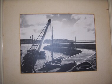
Photograph - Photograph - Fisherman's breakwater, Portland, n.d
On display at History House.Framed, black and white photograph of fishermen's breakwater Portland, showing breakwall crane and dinghies in foreground on breakwater. Fishing boats behind crane. Ocean pier, lighthouse bluff in background.Front: - Back: Mr. Barry Hocken Portland - in blue pencil -
Glenelg Shire Council Cultural Collection
Photograph - Photograph, framed collection - Early shipping history in Portland, Victoria, Early shipping history in Portland, n.d
UnknownFramed collection of photographs in brown timber frame, under glass. 1. Portland 1903; 2. Shipping at Ocean Pier; 3. Bullock teams in Julia Street; 4. Portland early 1900; 5. Portland early 1980s; 6. Fisherman's breakwater South East gale; 7. S.S. Stentor being loaded by lighters - wool; 8. Lifeboat practice early 20th century.Front: Portland 1903/ Shipping at Ocean Pier/ Bullock teams in Julia Street/ Portland early 1900/ Portland early 1980s/ Fisherman's breakwater South East gale/ S.S. Stentor being loaded by lighters - wool/ Lifeboat practice early 20th century. Back: (no inscriptions) -
Glenelg Shire Council Cultural Collection
Postcard - Postcard - Portland Bay, 1908
Coloured photo postcard. View of Portland Bay, looking north east from Henty Beach. Ocean Pier, Railway Pier, Fishermen's Breakwater, Couta Boat fishing fleet, remains of second Baths. Steamer at Ocean Pier and in bay. 'Portland Bay' - white print lower right edgeBack: Hand written message, black ink, from Rachel to Janice. Postmarked Portland, 18 May 1908 & Manchester UK 23 July 1908 -
Glenelg Shire Council Cultural Collection
Postcard - Postcard - Portland Harbour, n.d
Coloured photo postcard, white border. View over baths and harbour at Portland, looking south east. Third Portland Baths, Ocean Pier, Railway Pier, fishing boats, Fishermen's Breakwater, Battery Point. 'THE BATHS AND HARBOUR, PORTLAND', white print lower edge of photo. No stamp or postmark on reverseBack: Hand written message, blue biro -
 Glenelg Shire Council Cultural Collection
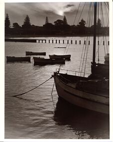
Photograph, Boats, n.d
Con Kroker Private CollectionBlack & white photos of several fishing boats and dinghies moored near Fishermans' Breakwater. Henty Beach in background. -
Glenelg Shire Council Cultural Collection
Photograph - Photographs -framed, Photograph - Construction Main Breakwater, n.d
Port of Portland CollectionTwo black and white photographs framed together. One shows tipping of first stones at the construction of the main breakwater. The other depicts the delivery of the first stones to the main breakwater.Front: "Tipping of the first stones at the construction of the main breakwater-17th November,1952. First stone delivered to main breakwater."port of portland -
Glenelg Shire Council Cultural Collection
Postcard, n.d
Black and white photo postcard, 'Rose' series. View of railway pier at Portland, from beach. Fisherman's Breakwater at rearFront: 'THE ROSE SERIES, P.1094' COPYRIGHT' 'THE PIER, PORTLAND VIC' - bottom border printed Back: Maker's details, logo. Handwritten message -
Glenelg Shire Council Cultural Collection
Book, Portland, Victoria Australia, c. 1984
Portland promotional book, produced for 150th celebrations. Cardboard covers; coloured photo images of Portland and surrounds on front cover; coloured photo image of harbour looking towards the opening between Lee Breakwater and K.S. Anderson Wharf, at sunrise. -
Glenelg Shire Council Cultural Collection
Photograph - Photograph - Portland, Victoria, n.d
Black and white photo looking from shore across to Battery Point. Baths, Ocean Pier, Railway Pier, Fishermen's Breakwater, 3 fishing boats under sail. Portland VictoriaBack: '56' in pencil -
Glenelg Shire Council Cultural Collection
Photograph - Photograph - Henty Beach, Portland Victoria, n.d
Black and white photo of Henty Beach Portland, looking south. Beach shelters, swings, dressing shed at end of pier, numerous people, Fishermen's Breakwater, Battery Point, Botanical gardens in the background.Back: '7338' - handwritten in pencil -
Glenelg Shire Council Cultural Collection
Postcard - Postcard - Photograph Portland, Victoria, n.d
Black and white photo postcard, looking towards Portland from the breakwaterFront: 'THE ROSE SERIES P 289' 'LOOKING TO THE TOWN FROM THE BREAKWATER PORTLAND VIC' - printed, bottom border -
Glenelg Shire Council Cultural Collection
Banner - Banner - Yesterday's Foundations, Nov-10
port of portland archives -
Glenelg Shire Council Cultural Collection
Photograph - Photograph - Portland Foreshore Victoria, 1970-1980
Coloured photograph of Portland foreshore showing Lee Breakwater and KS Anderson. -
Glenelg Shire Council Cultural Collection
Postcard - Postcard - Storm of 1923, Portland Harbour Victoria, c. 1923
Black and white photo postcard, taken during the storm of 1923. Man on Railway Pier, walking towards shore; big waves between Railway Pier and Fishermen's Breakwater, waves breaking over Fishermen's Breakwater -
Glenelg Shire Council Cultural Collection
Negative - Negative - Portland, Victoria, Zilah Maschmedt, c. 1934
Negative for a black and white photograph. Photo taken from grass track near beach at Portland, looking across harbour. Baths, Ocean Pier, Railway Pier, Fishermen's Breakwater and Henty Beach. -
Glenelg Shire Council Cultural Collection
Negative - Negative - View over Harbour, Portland Victoria, Zilah Maschmedt, 1961
Negative for a black and white photograph. Image shows view over Portland Harbour, Whalers Bluff and lighthouse, right foreground, Lee Breakwater, Ocean Pier, LS Anderson Wharf, Battery Point and Lawrence Rocks. -
Glenelg Shire Council Cultural Collection
Negative - Negative - Lee Breakwater under construction Portland, Victoria, Zilah Maschmedt, 1961
Negative for a black and white photograph. Image shows Lee Breakwater (SL Patterson) under construction, taken near old baths, Whaler's Bluff in background. -
Glenelg Shire Council Cultural Collection
Photograph - Photograph - Fishing Fleet at Portland, Victoria, n.d
Black and white photo. Fishing fleet at Portland. Couta boats, some with sails still unfurled, others at anchor, Fishermen's Breakwater, Battery Point in background. Photograph stuck to brown paper. -
Glenelg Shire Council Cultural Collection
Photograph, Softwoods Holdings Site, North Portland, April 1976, 1976
Port of Portland Authority archives.Back: Softwoods Holdings Site North Portland (lower left, pencil) APRIL, 1976 (lower left, blue pen) Portland Harbor Trust Commissioners (purple stamp, centre)port of portland -
Glenelg Shire Council Cultural Collection
Photograph, Main Breakwater Construction, n.d
Port of Portland Archivesport of portland, breakwater construction -
Glenelg Shire Council Cultural Collection
Photograph, n.d
Port of Portland Authority archives.Front: (no inscriptions) Back: No longer the property of G. Dunneport of portland, lee breakwater, portland bay -
Glenelg Shire Council Cultural Collection
Photograph, 1952
Port of Portland Authority archives.This forms part of the archives of the Port of Portland which were donated to the Glenelg Shire Cultural Collection by the Port of Portland. The collection documents the growth and significance of the Port of Portland.Front: Tipping of the first stones at the construction of the main breakwater - 17th November, 1952 (centre) First stone delivered to main breakwater (lower centre)port of portland, maritime, construction of breakwater -
Glenelg Shire Council Cultural Collection
Photograph - Photograph - oil tanks, n.d
Port of Portland Authority ArchivesBack: 2398 Lines drawn in biro 5 3/4" 4 1/8" 8036 s/s in pencilport of portland archives, oil tanks -
Glenelg Shire Council Cultural Collection
Photograph - Photograph - oil tanks, n.d
Port of Portland Authority Archivesport of portland archives, fishermans breakwater -
Glenelg Shire Council Cultural Collection
Photograph - Photograph - oil tanks, n.d
Port of Portland Authority ArchivesBack: 2398 Lines drawn in biro 5 3/4" 4 1/8" 8036 s/s in pencilport of portland archives, shell oil, portland, fishermans breakwater, satcol -
Glenelg Shire Council Cultural Collection
Photograph - Photograph - Lee Breakwater, Portland, n.d
Port of Portland Authority ArchivesBack: 5 pg 95/27/11-62 - blue biroport of portland archives, lee breakwater, nuns beach, lighthouse, portland, harbour -
Glenelg Shire Council Cultural Collection
Photograph - Photograph - Lee Breakwater, n.d
Port of Portland Authority Archivesport of portland archives, lee breakwater -
Glenelg Shire Council Cultural Collection
Photograph - Photograph - Lee Breakwater, Portland, n.d
Port of Portland Authority Archivesport of portland archives, lee breakwater, tanker berth, wharf, harbour, barge