Showing 107 items matching "canterbury maps"
-
 Canterbury History Group
Book, Richard Broome, Remembering Melbourne 1850-1960, 2016
A book of over 700 black and white illustrations and photographs of early Melbourne scenes, mainly buildings, which have been demolished or significantly changed. The first half of the book concentrates on the CBD but includes public gardens and the Yarra River. The second half of the book looks at a number of the inner suburbs including Footscray.Large red covered book with black and white dust cover featuring panoramic view of Princes Bridge looking North. 366 pages : photographs, 1 map, portraits. Includes bibliographical references and indexnon-fictionA book of over 700 black and white illustrations and photographs of early Melbourne scenes, mainly buildings, which have been demolished or significantly changed. The first half of the book concentrates on the CBD but includes public gardens and the Yarra River. The second half of the book looks at a number of the inner suburbs including Footscray.historical buildings - melbourne, melbourne - history, canterbury - history -
Canterbury History Group
Book, Judy Archer, Searching for Gold, 2021
"The story of Annie Kennedy Gold who was abandoned at birth. Her life and times and some of the characters who crossed her path. 'Her marriage to our Grandfather, Richard Henry Archer, an account of his background history, and some memories of the family home in Glenroy."230 pages; illustrations, map, portraits, facsimiles non-fiction"The story of Annie Kennedy Gold who was abandoned at birth. Her life and times and some of the characters who crossed her path. 'Her marriage to our Grandfather, Richard Henry Archer, an account of his background history, and some memories of the family home in Glenroy."family history, duneira, biography, genealogy -
Canterbury History Group
Pamphlet - A Golding Walk in Canterbury, Robin Da Costa-Adams, 2006
Brochure prepared by Robin Da Costa- Adams for the walk she led on behalf of the Canterbury History Group, 2006. Includes illustrations, photographs and a map of the sites covered.canterbury, balwyn road, mont albert road, canterbury road, rochester road, john august reserve, balwyn wesleyan/methodist church, "the pines", golding family, tibbets> william, churches, factories, halls -
Canterbury History Group
Document - Canterbury Mansions and Stables, 13/03/1991 12:00:00 AM
... many photographs and 2 maps Document Canterbury Mansions ...Photocopy of a document relating to the Draft Statement of Significance for Canterbury Mansions. Contains a short history of Canterbury, the role the hotel has played in that history, and descriptions of the interior and exterior. Includes many photographs and 2 mapscanterbury, canterbury mansions, canterbury club hotel, canterbury road, city of boroondara, historic buildings register, jacob lewis vines, malone family, temperance movement, wattle valley road, stables, outbuildings -
Canterbury History Group
Map - Elgar's Special Survey, copied 1989
Map of "Elgar's Special Survey" 8 square miles chosen by Henry Elgar in 1841, showing the location of J.B.Maling's Paddock and house, 13 acres bought in 1864.camberwell, balwyn, deepdene, canterbury, surrey hills, elgar's special survey, land subdivision, maps, maling family -
 Victorian Railway History Library
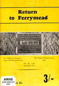
Book, N.Z. Railway & Locomotive Society, Canterbury Branch : Tramway Historical Society, Return to Ferrymead, 1966
A history of the railways of Ferrymead - the site of the first steam operated railway in New ZealandIll, maps, p.26.non-fictionA history of the railways of Ferrymead - the site of the first steam operated railway in New Zealandhistory of railways - new zealand, railways - ferrymead -
 Victorian Railway History Library
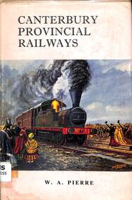
Book, Pierre, W.A, Canterbury Provincial Railways - Genesis of the N.Z.R System, 1964
... it's 5'3" gauge days. index, ill, maps, p.190. Canterbury ...A history of the Canterbury Provincial Railway out of Christchurch in the South Island New Zealand from it's 5'3" gauge days.index, ill, maps, p.190.non-fictionA history of the Canterbury Provincial Railway out of Christchurch in the South Island New Zealand from it's 5'3" gauge days.railroads - new zealand - south island - history, railroads construction - new zealand -
 Victorian Railway History Library
Booklet, N.Z. Railway & Locomotive Society, Canterbury Branch : Tramway Historical Society, Return to Ferrymead, 1966
A history of the railways of Ferrymead - the site of the first steam operated railway in New ZealandIll, maps, p.28.non-fictionA history of the railways of Ferrymead - the site of the first steam operated railway in New Zealandhistory of railways - new zealand, railways - ferrymead -
 Ringwood and District Historical Society
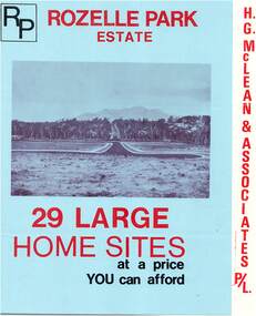
Flyer, Subdivisional Land Sale Brochure, Rozelle Park Estate, Ringwood East, Vic. - circa 1968
Folded land subdivision sale advertisement for 29 home sites, with location map and summary of local facilities and services. Separate price list leaflet enclosed with terms of sale.Subdivision includes Wingate Avenue and Rozelle Avenue, Ringwood East. Agent - H.G. McLean & Associates Pty. Ltd., 166 Canterbury Road, Heathmont. Phone 870 3422 A/H 870 5879. -
 Ringwood and District Historical Society
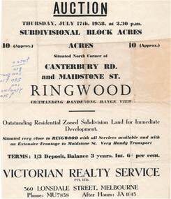
Flyer - Land Auction Sale, Ten Acres, Maidstone Street Ringwood - 1958
Double sided page advertising Auction, Thursday, July 17th, 1958, (Approx.) 10 Acres, north corner of Canterbury Road and Maidstone Street, Ringwood. Agents - Victorian Realty Service Pty.Ltd., 360 Lonsdale Street, Melbourne, Phone MU7858, After Hours JA1045. Reverse side shows map of proposed subdivision by K.J. Noonan & Co., Surveyors & Engineers, 495 St.Kilda Rd, Melbourne, marked subject to approval of all interested statutory authorities.Residential zoned subdivision land for immediate development. Extensive frontage to Maidstone Street. Accompanying handwritten annotation "10 acres offered as a whole, later re-subdivided". -
 Ringwood and District Historical Society
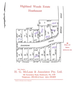
Document, Subdivision Plan - Highland Woods Estate, Heathmont, Victoria (undated, circa 1968)
Map of 15 residential allotments for sale, with seven rubber-stamped SOLD and one with handwritten notation "$5650 1968". Subdivision includes Barrow Drive and Barnic Road, Heathmont. Agent - H.G. McLean & Associates Pty. Ltd., 166 Canterbury Road, Heathmont Vic., 3135, Telephones : 870-3422 A/hrs 870-5879. -
 Ringwood and District Historical Society
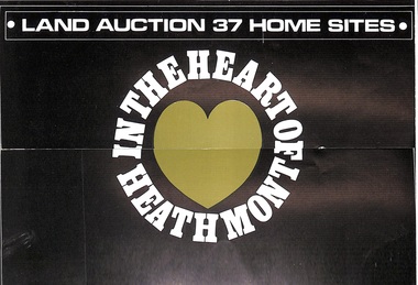
Pamphlet, Land Auction Brochure - Heathmont Hills Estate, Heathmont, Vic
... , with locality map. Subdivision includes Canterbury Road, Cuthbert Street..., with locality map. Subdivision includes Canterbury Road, Cuthbert Street ...Multi-fold brochure advertising auction of 37 home sites on Saturday May 6th, (1967?). Brochure includes terms of sale, description of subdivision features and local facilities, with locality map. Subdivision includes Canterbury Road, Cuthbert Street, and Craig Court, off Balfour Avenue, Heathmont. Agent - N.R. Reid & Co Pty Ltd., 173 Coleman Parade, Glen Waverley, (phone) 560 0355 A.H. 28 3185, in conjunction with H.G. McLean Pty Ltd., 166 Canterbury Road, Heathmont, 87 7808 A.H. 842 2708. -
 Victorian Railway History Library
Book, Maffey, I.D, The Mount Somers Tramway 1886-1943, 1971
A history of the Mount Somers Tramway in the mid-Canterbury region of the South Island of New Zealand.index, ill, maps, p.113.non-fictionA history of the Mount Somers Tramway in the mid-Canterbury region of the South Island of New Zealand.railroad construction - new zealand, railroad operations - new zealand -
 Ringwood and District Historical Society
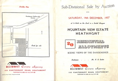
Flyer - Land Sales Brochure, Sub-Divisional Sale by Auction - Mountain View Estate, Heathmont, Victoria - 1957
Bi-fold pamphlet advertising auction of 20 residential allotments on Saturday, 14th December, 1957, with description of services available and finance terms. Subdivision inclues Orchard Grove and Barnic Road. Agent - Heathmont Estate Agency, 103 Canterbury Road, Heathmont, Telephone WU6808, after hours WF1488. Auctioneer Mr. A.B. Carter. Accompanying Parish of Ringwood survey map with cardboard backing - Part of Crown Allotment 14B, includes handwritten price notations for each allotment. -
 Canterbury History Group
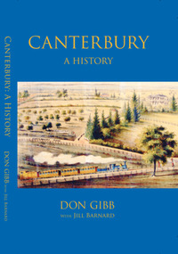
Book, Don Gibb et al, Canterbury: a history, 2022
... of the suburb of Canterbury, Victoria from its Aboriginal history ...Canterbury: A History covers the history of the suburb of Canterbury, Victoria from its Aboriginal history as part of the country of the Wurundjeri people to its completed development as a middle-class suburb by the late 1950s. The book had been a labour of love by esteemed historian, Don Gibb, for many years. Don’s sudden death in late 2017 left the manuscript uncompleted. The Canterbury History Group and the Royal Historical Society of Victoria, together with Don’s family, were determined to see Don’s book completed and published. Jill Barnard contributed the final two chapters dealing with the inter war and post-World War II decades.187 pages : illustrations, maps, portraits, facsimilesnon-fictionCanterbury: A History covers the history of the suburb of Canterbury, Victoria from its Aboriginal history as part of the country of the Wurundjeri people to its completed development as a middle-class suburb by the late 1950s. The book had been a labour of love by esteemed historian, Don Gibb, for many years. Don’s sudden death in late 2017 left the manuscript uncompleted. The Canterbury History Group and the Royal Historical Society of Victoria, together with Don’s family, were determined to see Don’s book completed and published. Jill Barnard contributed the final two chapters dealing with the inter war and post-World War II decades.canterbury, canterbury history, residential development, maling road, gibb> don -
Canterbury History Group
Document - The Grange, 1905
MMBW detailed map of "The Grange" 1905. Includes a short history of the house by Don Gibbcanterbury, the grange, fintona junior school, st. duthies, mont albert road, maps, gibb> don -
Canterbury History Group
Book, Gwen McWilliam, Early Canterbury, 1994
... : illustrations, maps, facsimiles Early Canterbury Book Gwen McWilliam ...Early history of Canterbury with a focus on the "Shrublands" property of Balwyn Road.22, [2 leaves] pages : illustrations, maps, facsimilesnon-fictionEarly history of Canterbury with a focus on the "Shrublands" property of Balwyn Road.canterbury, canterbury history, residential development, shrublands -
 Ringwood and District Historical Society
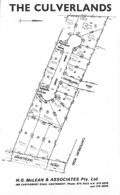
Document, Subdivision Plan - The Culverlands Estate, Heathmont, Victoria (undated, circa 1968)
Map of residential allotments for sale, with handwritten pricing notations and some marked "Sold". Subdivision includes Culverlands Road, Swain Court, Pleasant Drive, Barbara Court, and Armstrong Road, Heathmont. Agent - H.G. McLean & Associates Pty. Ltd., 166 Canterbury Road, Heathmont Vic., 3135, Telephones : 870-3422 A/hrs 870-5879 and 729-2809. -
Canterbury History Group
Document - Thematic Environmental History, Built Heritage, 1/05/2012
Thematic Environmental Heritage. Final document produced, after community consultation, for the City of Boroondara by Built Heritage242 pages city of boroondara, back yards, canterbury, churches, cottages, dairies, danks family, elgar survey, exploration, frognall, goldings boot factory, maling road, malone's hotel, maps, masonic lodges, national parks, native plants, outer circle railway line, police stations, post offices, railways, rochester road, schools, shrublands, soldiers memorial hall, sport, telephone exchanges, theatres, transport, wildlife, canterbury road, land subdivisions, parks and reserves -
 Ringwood and District Historical Society
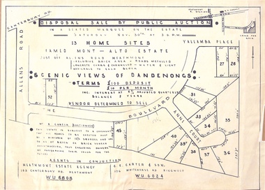
Flyer - Auction, Mont-Alto Estate, Heathmont, Victoria - circa 1960
Single page advertisement for auction of 13 home sites on Saturday 30th November (1957?) with map of subdivsion, terms of sale, and reference to brick covenant. Subdivision includes Yallamba Place, The Boulevard, and Anne Court, Heathmont. Agents - Heathmont Estate Agency, 103 Canterbury Road, Heathmont (Telephone) WU6808, and C.E. Carter & Son, 126 Whitehorse Road, Ringwood, WU6024. Auctioneer - Mr. A. Carter."This Estate is subject to a covenant that all homes to be erected must be a minimum of 12-1/2 squares and are to be of brick or brick veneer construction, thus ensuring owners of preserving their value for the future." -
 Whitehorse Historical Society Inc.
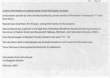
Document - Real estate notes, maps, flyers, Trove Park Estate, 1969, 2022
A history of the Trove Park Estate, Vermont from 1880's to 2022 is provided by notes, maps, pictures and auction flyers. The Estate was originally part of the Uplands Estate of 34 acres in the Mount Pleasant district.A history of the Trove Park Estate, Vermont from 1880's to 2022 is provided by notes, maps, pictures and auction flyers. The Estate was originally part of the Uplands Estate of 34 acres in the Mount Pleasant district.A history of the Trove Park Estate, Vermont from 1880's to 2022 is provided by notes, maps, pictures and auction flyers. The Estate was originally part of the Uplands Estate of 34 acres in the Mount Pleasant district.trove park drive estate vermont, mt pleasant, trove park, uplands vermont, bishop edward, round chris & murray, mulcahy mendelson & round, trove park drive vermont no 7 -
Canterbury History Group
Map - Logan Estate, Canterbury
... history on the reverse side. Map Logan Estate, Canterbury ...Real estate advertisement distributed by Sinclair & Company of a reproduction of a historical map of the Logan Estate and a short history on the reverse side.canterbury, logan estate, canterbury road, prospect hill road, marlowe street, logan street, canterbury railway station, logan family, sinclair & company, clairmont estate, molesworth street -
Canterbury History Group
Map - Victorian Railways, Canterbury, Drainage Plan, cc1910
... Canterbury Canterbury Road Maling Road Canterbury Station ...Drainage plan around Canterbury Station, Canterbury Road and Maling Road .5 pages of photocopies from the Public Record Officecanterbury, canterbury road, maling road, canterbury station, drainage, stormwater channels -
Canterbury History Group
Document - Frognall - History, Royal Australian Air Force
Photocopy of a 38 page booklet compiled by Royal Australian Air Force Engineers Cadet Squadron , includes maps, house floor plan, photographs and footnotescanterbury, royal australian air force engineers cadet squadron, hicks> clarence, laycock> burdett, frognall, mont albert road, maps, elgar's special survey -
Canterbury History Group
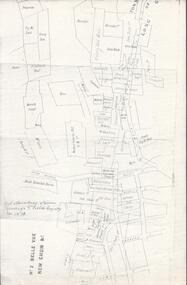
Map - Canterbury Subdivisions
... Park Estate Great Railway Estate Grange Estate Map Canterbury ...A collection of 6 maps with notations showing the names and dates of land subdivision in Canterbury and surrounding suburbs.canterbury, logans estate, shrublands estate, claremount park estate, arklow hill estate, griffin estate, monomeath estate, mont albert park estate, great railway estate, grange estate -
 Bendigo Historical Society Inc.
Map - BELLE VUE NO 2 - PLAN OF LEASES
BHS CollectionPlan of Mining Leases from Rowan Street to Long Gully. Reference J. N. Macartney 2nd Edition Bendigo Goldfields Registry for 1872. Names of Leases are: Moore ?, Ellesmere Co, Bonati & Co, Dennis, Abe Lincoln Co, Lansell & Hunt, Black & White Lead Co, Koch & Hildebrand, Ballerstedt, Lazarus Co No 1, Lazarus Co, Watson, Lazarus Freehold, Lazarus Co No 2, Lazarus Tribute, South Extended Burra, Endeavor Co, Old Chum Co, Burrows and Sterry, New Chum & Victoria Trib, Jackson, North Old Wybrants Chum Co, Myra Co, McLenn, Geary & Co, Western Victoria Hill G. M. Co, Victoria Reef G.M.Co, South Adventure Co, South Try Me Well, W. Rae, Wells Midway, Extended Co, Handy Andy, Moonta Co, Humboldt Co, Adventure Co, Try Me Well, Sterry & Co, Midway, Tudor, Friedman's Reef, Rising Sun, Try Me Luck, Pomponia, Confidence Co, Alfred Co, Advance Co, Prince Alfred Co, Canterbury Co, Platus Co, S. Platus Co, Golden Fleece United, Alfred Co, Iron Duke Co, Victoria Gold Mines Co, Hercules Co and Iron Bark. Notes prepared by Albert Richardson.map, bendigo, mining plan, belle vue no 2, no 2 belle vue new chum & c, j n macartney bendigo goldfields registry 1872, moore ?, ellesmere co, bonati & co, dennis, abe lincoln co, lansell & hunt, black & white lead co, koch & hildebrand, ballerstedt, lazarus co no 1, lazarus co, watson, lazarus freehold, lazarus co no 2, lazarus tribute, south extended burra, endeavor co, old chum co, burrows and sterry, new chum & victoria trib, jackson, north old wybrants chum co, myra co, mclenn, geary & co, western victoria hill g. m. co, victoria reef g.m.co, south adventure co, south try me well, w. rae, wells midway, extended co, handy andy, moonta co, humboldt co, adventure co, try me well, sterry & co, midway, tudor, friedman's reef, rising sun, try me luck, pomponia, confidence co, alfred co, advance co, prince alfred co, canterbury co, platus co, s. platus co, golden fleece united, alfred co, iron duke co, victoria gold mines co, hercules co, iron bark -
Canterbury History Group
Book, Chris McConville and Associates, Camberwell Conservation Study: Environmental History, 12 December 1989
Draft report prepared for the City of Camberwell and submitted to the Advisory Committee on 12 December 1989. Volume 1.Spiral bound; 136 pages; includes B&w sketches, maps and photocopies of photosnon-fictionDraft report prepared for the City of Camberwell and submitted to the Advisory Committee on 12 December 1989. Volume 1.camberwell city of, monomeath avenue, victoria avenue, logan street, duncan & weller, canterbury, canterbury road, canterbury gardens, canterbury concert committee, fountains, rotundas, logans paddock, keats street, golding family, mellor> l a, chaucer crescent -
Whitehorse Historical Society Inc.
Map, Husband Road, Forest Hill, 1972
Enlarged aerial photo of area between Canterbury and Husband Roads Forest Hill. Melbourne, 1972Enlarged aerial photo of area between Canterbury and Husband Roads Forest Hill. Melbourne, 1972Enlarged aerial photo of area between Canterbury and Husband Roads Forest Hill. Melbourne, 1972canterbury road, forest hill, husband road, forest hill, hylton crescent, forest hill, sapphire street, forest hill, opal street, forest hill, amber street, forest hill, willurah street, forest hill, nunawading swimming pool, aerial photographs, nunawading memorial swimming pool, nunawading pool, aqualink nunawading -
 Ringwood and District Historical Society
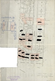
Document, Map showing numbered subdivision allotments with hand-written notations and redactions - 1924
Foolscap size page Map by Arnold Wilson & Associates, Engineers & Surveyors, 399 St.Kilda Road, Melbourne, Tel 26-1840 - 1924/4. Subdivision includes Ilford Road, Karen Court, Washusen Road and Dirkala Avenue, Heathmont. Also includes hand-drawn allotments on Canterbury Road and Balfour Avenue. Page rubber-stamped by building company A & C Jaworski, Office 2, 23 Ringwood Street, Ringwood 3134, Tel 870-0820, A.H. 870-2062. -
 Ringwood and District Historical Society
Document - Map, Plan of Subdivision - Part of Crown Allotments 14A & 14C, Parish of Ringwood, County of Mornington, Vol 5378 Fol 511 - 1927
... Map includes Canterbury Road, Heathmont Road, Dickasons...Map includes Canterbury Road, Heathmont Road, Dickasons ...Department of Lands and Survey photocopy dated 17/1/1951, page number 12308.Map includes Canterbury Road, Heathmont Road, Dickasons Road, Bennett Avenue, Orchid Street and Allens Road, Heathmont, Vic.